
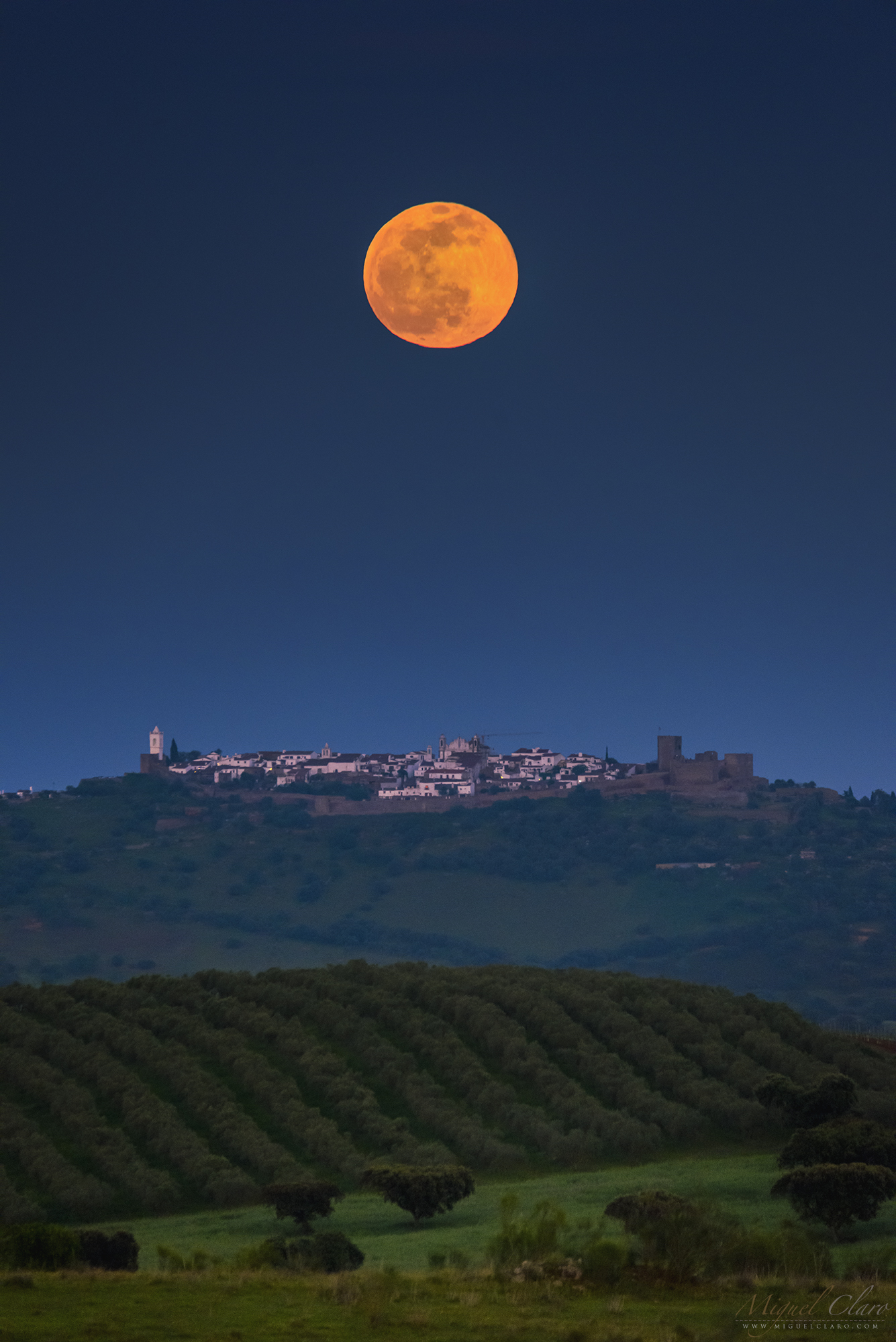
April Full Moon Rising Like an Easter Egg above Monsaraz Castle

The last Full moon was literally an Easter moon. Why, because it was rising like an egg. Even looking round at a first sight, take a look below on the left portrait, which shows exactly this same picture but rotated to a vertical position. It’s like an optical illusion. In fact Dr. Les Cowley from Atmospheric Optics, explains why a spherical object appears flattened near the horizon: “Rays from the setting sun are refracted by the atmosphere and make it appear higher in the sky. The lower limb is lifted more than the top limb, making its image oval.” The same could happen with the moon when its light is crossing different layers at different pressures and temperatures. The light is bent and distorts the image forming the Easter Egg shape. The single image captured with a 600mm at a distance of 8,2 km, shows the moon rising above Monsaraz Castle in Dark Sky® Alqueva Reserve, Portugal. The image on the right, was captured a few minutes later at a focal of 400mm (200mm + 2x extender) when the moon was a little bit higher.
PT: A última lua cheia de Abril foi literalmente uma lua de Páscoa. Porquê ? Porque nasceu com a forma de um ovo. Mesmo parecendo redonda à primeira vista, a imagem em modo retrato que é possível ver em baixo à esquerda, mostra exatamente esta mesma fotografia, mas na posição vertical. Parece uma incrível ilusão óptica. Na verdade, Dr. Les Cowley, especialista do Atmospheric Optics, explica por que um objecto esférico parece achatado perto do horizonte: “Os raios do sol poente são refractados pela atmosfera e fazem com que este pareça mais alto no céu. O limbo inferior é eleva-se mais do que o limbo superior, tornando a sua imagem oval.” O mesmo pode acontecer com a lua quando a sua luz atravessa diferentes camadas da atmosfera, a diferentes pressões e temperaturas. A luz é “dobrada” e distorce a imagem apresentando o formato de “ovo de Páscoa”. A imagem é resultado de um disparo único captado com uma teleobjectiva de 600mm à distância de 8,2 km, e revela o nascimento da Lua Cheia sobre o Castelo de Monsaraz na Reserva Dark Sky® Alqueva, em Portugal. A imagem da direita, captada alguns minutos mais tarde com outra objectiva de 200mm + duplicador (2x), revela um enquadramento similar com a Lua mais elevada no céu.

BUY THIS PRINT | COMPRAR ESTA IMPRESSÃO
Buy a Fine Art Print or Wall Decor of this Image – Make your order Now!
You can choose the best style of print do you preffer to decorate in a fashion way your walls. Metal Prints with durable and vivid colors, Acrylic, Canvas or the highest quality Gallery Print – a 6 colour UV direct printing on acrylic glass (2mm) including light colours and reinforced by an aluminium dibond plate (3mm). Those type of Prints can highlight the final work in an artistic way, showing the photograph as a piece of art. I work with two high quality specialized Labs in US and in Europe, using Kodak Professional Endura Premier Metallic papers and Fujifilm Crystal Archive DP II Professional. You can select the image above or freely navigate to more than 800 photographs available in my gallery – each one with their own story and magic – and choose the photograph you would love to have in your home or office.
How to Order – Simple and easy, just “copy and paste” the link of this page or the image you choosed and fill it in the form below, with the size you want and any detail you wish to include on the message, like your country, name and postal address. Free Shipping included to all prints (except frames). For US and Europe the delivery is 4-8 working days, while to Portugal and Spain is normally 2-6 working days. After submitting the order through the form, I will contact you for the payment method (Paypal available or bank transfer) and with other questions related to your print(s) or requests. Once payment is confirmed, your order is shipped within 24h. In case you wish, I can send you separtely with no additional cost, a postcard autographed and numbered of the same image you have just bought, as a seal and proof of art work authenticity from the author. Let me know what is your wish.
Milky Way All Sky and VR 360º Night Experience above Castro de Palheiros in Dark Sky® Vale do Tua
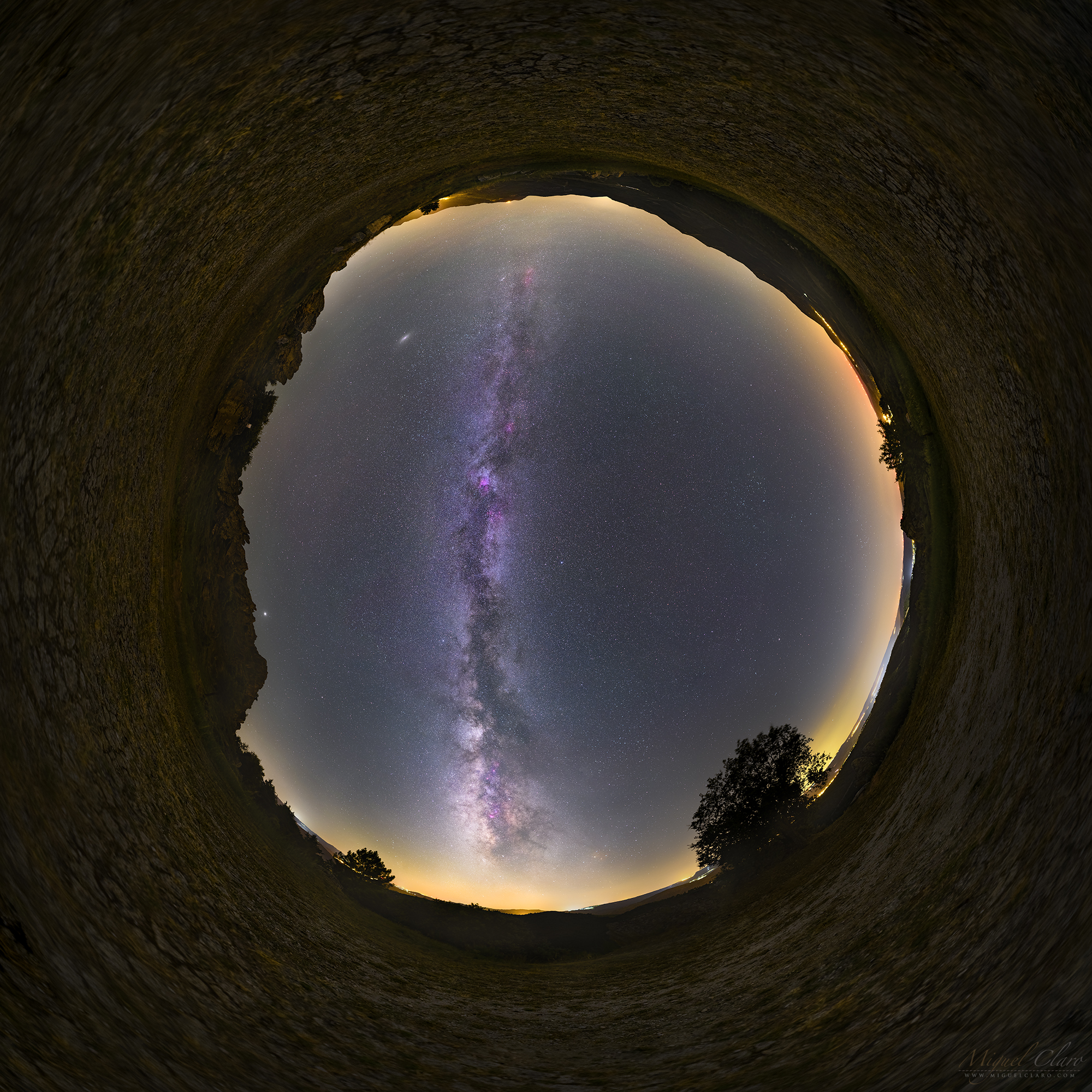
A full dome and 360º Virtual Reality scene features the path of Milky Way shining high in the night sky, above Castro de Palheiros, or Fragada of Castro, territory of Dark Sky® Vale do Tua – a new certified Starlight Tourist Destination. Located in the heart of Natural Park of Tua Valley, in the northern part of Portugal, “is an imposing quartzite ridge that was being carved and built by the people of Murça region, between the beginning of the third millennium BC up to the present”, according to the Interpretative Center of this region. In the background, Summer Triangle highlights the center of the image, with blueish star Vega near the top. At the upper left corner – in the beginning of the Milky Way – a bright elliptic and diffuse dot is the light coming from Andromeda Galaxy. In the opposite direction – lower horizon – shines the dusty core of Milky Way galaxy full emission nebulae featuring a reddish pink hues. On the left side of the all sky scene – lies also planets Jupiter, visible with its bright light near the quartzite rock. Below is available a Virtual Realities 360º of this scene. You can experience a full 7K resolution using your desktop, or smartphone with gyroscope. A great “in loco” experience can be achieved if you wear a VR glasses.
PT: Um cenário All Sky e de Realidade Virtual 360º, apresenta o caminho da Via Láctea brilhando alto no céu noturno, acima do Castro de Palheiros, ou Fragada de Castro, território do Dark Sky® Vale do Tua – um novo Destino Turístico Starlight certificado. Situado no coração do Parque Natural do Vale do Tua, no norte de Portugal, o Castro “é uma imponente crista quartzítica que foi sendo esculpida e construída pelas populações da região de Murça, entre o início do terceiro milénio antes de Cristo até ao presente, segundo o Centro Interpretativo da região. Em pano de fundo, destaca-se o Triângulo do Verão ao centro da imagem, com a estrela azulada Vega a brilhar próximo do centro. No canto superior esquerdo – no início da Via Láctea – um ponto elíptico brilhante e difuso, pertence à luz da Galáxia vizinha de Andrómeda. Na direção oposta, perto do horizonte inferior, brilha o núcleo empoeirado da nossa galáxia Via Láctea, salpicado por uma imensidão de nebulosas de emissão que brilham em tons de rosa avermelhado. No lado esquerdo desta imagem circular de grande campo, encontram-se os planeta Júpiter, bem visível com a sua luz brilhante. Abaixo estão disponíveis duas Realidades Virtuais 360º desta imagem. O leitor pode assim experienciar esta Realidade Virtual em alta-resolução 7K usando o seu desktop ou smartphone com giroscópio. Uma ótima experiência “in loco” pode ser alcançada se usar óculos de realidade virtual.
BUY THIS PRINT | COMPRAR ESTA IMPRESSÃO
Buy a Fine Art Print or Wall Decor of this Image – Make your order Now!
You can choose the best style of print do you preffer to decorate in a fashion way your walls. Metal Prints with durable and vivid colors, Acrylic, Canvas or the highest quality Gallery Print – a 6 colour UV direct printing on acrylic glass (2mm) including light colours and reinforced by an aluminium dibond plate (3mm). Those type of Prints can highlight the final work in an artistic way, showing the photograph as a piece of art. I work with two high quality specialized Labs in US and in Europe, using Kodak Professional Endura Premier Metallic papers and Fujifilm Crystal Archive DP II Professional. You can select the image above or freely navigate to more than 800 photographs available in my gallery – each one with their own story and magic – and choose the photograph you would love to have in your home or office.
How to Order – Simple and easy, just “copy and paste” the link of this page or the image you choosed and fill it in the form below, with the size you want and any detail you wish to include on the message, like your country, name and postal address. Free Shipping included to all prints (except frames). For US and Europe the delivery is 4-8 working days, while to Portugal and Spain is normally 2-6 working days. After submitting the order through the form, I will contact you for the payment method (Paypal available or bank transfer) and with other questions related to your print(s) or requests. Once payment is confirmed, your order is shipped within 24h. In case you wish, I can send you separtely with no additional cost, a postcard autographed and numbered of the same image you have just bought, as a seal and proof of art work authenticity from the author. Let me know what is your wish.
Milky Way Above the Medieval Castle of Juromenha

The image show a vertical panorama of the Milky Way as seen at the end of summer from inside the medieval castle of Juromenha in Dark Sky® Alqueva certified territory, in Portugal. The occupation of its site dates back to the Gallo-Celts and the Romans. Later occupied during the Muslim invasion of the Iberian Peninsula, at the time of the Christian Reconquest of the peninsula it remained for two centuries as a defence outpost of the important city of Badajoz, since the 10th century in the hands of the Caliphate of Cordoba. The village and medieval castle, were then conquered in 1167 by the troops of Portuguese King Afonso Henriques (1112-1185).
PT: A imagem mostra um panorama vertical da Via Láctea visível no final do Verão e a partir do castelo medieval de Juromenha, no território certificado do Dark Sky® Alqueva, em Portugal. A ocupação do seu sítio remonta aos galo-celtas e aos romanos. Mais tarde ocupado durante a invasão muçulmana da Península Ibérica, na época da Reconquista Cristã da península, permaneceu durante dois séculos como posto avançado de defesa da importante cidade de Badajoz, desde o século X nas mãos do Califado de Córdoba. A vila e o castelo medieval, foram então conquistados em 1167 pelas tropas do rei português Afonso Henriques (1112-1185).
BUY THIS PRINT | COMPRAR ESTA IMPRESSÃO
Buy a Fine Art Print or Wall Decor of this Image – Make your order Now!
You can choose the best style of print do you preffer to decorate in a fashion way your walls. Metal Prints with durable and vivid colors, Acrylic, Canvas or the highest quality Gallery Print – a 6 colour UV direct printing on acrylic glass (2mm) including light colours and reinforced by an aluminium dibond plate (3mm). Those type of Prints can highlight the final work in an artistic way, showing the photograph as a piece of art. I work with two high quality specialized Labs in US and in Europe, using Kodak Professional Endura Premier Metallic papers and Fujifilm Crystal Archive DP II Professional. You can select the image above or freely navigate to more than 800 photographs available in my gallery – each one with their own story and magic – and choose the photograph you would love to have in your home or office.
How to Order – Simple and easy, just “copy and paste” the link of this page or the image you choosed and fill it in the form below, with the size you want and any detail you wish to include on the message, like your country, name and postal address. Free Shipping included to all prints (except frames). For US and Europe the delivery is 4-8 working days, while to Portugal and Spain is normally 2-6 working days. After submitting the order through the form, I will contact you for the payment method (Paypal available or bank transfer) and with other questions related to your print(s) or requests. Once payment is confirmed, your order is shipped within 24h. In case you wish, I can send you separtely with no additional cost, a postcard autographed and numbered of the same image you have just bought, as a seal and proof of art work authenticity from the author. Let me know what is your wish.
A lovely Moonrise in the Winter Sky above Lagoa do Fogo in Azores

Probably one of the most beautiful moonrises I have witness in many many years. Captured literally in middle of Atlantic Ocean, in the island of São Miguel, Azores, Portugal, the image reveals a panorama of single images taken around midnight from Lagoa do Fogo (Lake of Fire).The blue lake is located at 575 meters above the sea level – it is about 2 km long and 1 km wide – filling the ground of an extinct crater, whose caldera was formed during an eruption in 1563. In the background, a winter sky shows the bright light of the moon while rising between the mountains and against Auriga and Taurus constellation. Pleiades, is the blueish star cluster visible at center right. Near the left edge, stars from Big Dipper (Ursa Major) are very well visible above a layer of white clouds
PT: Provavelmente um dos mais belos nasceres da lua que já testemunhei em muitos anos. Captada literalmente em pleno Oceano Atlântico, na ilha de São Miguel, Açores, Portugal, a imagem revela um panorama de disparos únicas, feitos por volta da meia-noite a partir da Lagoa do Fogo. Esta lagoa azul está localizada a 575 metros acima do nível do mar – tem cerca de 2 km de comprimento e 1 km de largura – enchendo o solo de uma cratera extinta, cuja caldeira foi formada durante uma erupção em 1563. Em pano de fundo, um céu de inverno mostra a luz brilhante da lua enquanto esta se ergue por entre as montanhas e contra a constelação de Auriga e Taurus. As Pleiades são o aglomerado de estrelas azulado – por serem ainda jovens e quentes – visível no centro à direita. Perto do extremo esquerdo da imagem, as estrelas da Ursa Maior (Ursa Major) são bem visíveis acima de uma camada de nuvens brancas.
BUY THIS PRINT | COMPRAR ESTA IMPRESSÃO
Buy a Fine Art Print or Wall Decor of this Image – Make your order Now!
You can choose the best style of print do you preffer to decorate in a fashion way your walls. Metal Prints with durable and vivid colors, Acrylic, Canvas or the highest quality Gallery Print – a 6 colour UV direct printing on acrylic glass (2mm) including light colours and reinforced by an aluminium dibond plate (3mm). Those type of Prints can highlight the final work in an artistic way, showing the photograph as a piece of art. I work with two high quality specialized Labs in US and in Europe, using Kodak Professional Endura Premier Metallic papers and Fujifilm Crystal Archive DP II Professional. You can select the image above or freely navigate to more than 800 photographs available in my gallery – each one with their own story and magic – and choose the photograph you would love to have in your home or office.
How to Order – Simple and easy, just “copy and paste” the link of this page or the image you choosed and fill it in the form below, with the size you want and any detail you wish to include on the message, like your country, name and postal address. Free Shipping included to all prints (except frames). For US and Europe the delivery is 4-8 working days, while to Portugal and Spain is normally 2-6 working days. After submitting the order through the form, I will contact you for the payment method (Paypal available or bank transfer) and with other questions related to your print(s) or requests. Once payment is confirmed, your order is shipped within 24h. In case you wish, I can send you separtely with no additional cost, a postcard autographed and numbered of the same image you have just bought, as a seal and proof of art work authenticity from the author. Let me know what is your wish.
A Stargazer Enjoying the view in a World of Contrasting Realities

This single shot features a stargazer enjoying Andromeda galaxy, possible to se with the naked-eye from the newest territory of Dark Sky® Vale do Tua, in northern part of Portugal – a new certified Starlight Tourist Destination. Being one of the best spots to enjoy archeoastronomy, in the foreground we can see the silhouette from Forca do Freixiel, an ancient gallows from Middle Ages. The monument is believed to be unique in the Iberian Peninsula. It is formed by of 2 vertical granite pillars that supported a horizontal beam – which no longer exists – where was placed the noose. In this type of gallows, the condemned did not die by strangulation due to suspension, but by a garrote, being later on display in the gallows. The image pretends to show the contrasting reality between the morbid meaning from acts of ancient times, with our responsibility of respecting the history but evolving as better human beings while living in such a beautiful planet, we need an effort to keep preserving the beauty of the night sky. In the background, featuring the Andromeda in the middle of the scene, at left side, the orange planet Mars can be seen setting near the mountains while in the opposite direction, is visible the path of winter Milky Way against a starry sky in the presence of smooth greenish airglow.
PT: Num disparo único a imagem mostra um observador de estrelas apreciando a galáxia de Andrómeda, possível de observar a olho nu no Dark Sky® Vale do Tua, no norte de Portugal – é o mais recente destino turístico Starlight certificado. Sendo um dos melhores locais para desfrutar da arqueoastronomia, em primeiro plano, avista-se a silhueta da Forca do Freixiel, uma forca milenar da Idade Média. O monumento é considerado único na Península Ibérica. É formada por 2 pilares verticais de granito que suportavam uma viga horizontal – que já não existe – onde foi colocado o laço. Neste tipo de forca, o condenado não morria por estrangulamento por suspensão, mas por garrote, sendo posteriormente exposto na forca. A imagem pretende mostrar a realidade contrastante entre o sentido mórbido de actos da antiguidade, com a nossa responsabilidade actual em respeitar a história, mas simultaneamente evoluir como seres humanos melhores, enquanto habitantes de um planeta único, precisamos de um esforço e empenho contínuo para preservar a beleza do céu noturno. Em pano de fundo é possível ver a galáxia de Andrómeda no centro do enquadramento e à esquerda, o planeta Marte. Com a sua tonalidade alaranjada, prepara-se para desaparecer por detrás das montanhas, enquanto na direção oposta, é visível o caminho da Via Láctea de inverno contra um céu estrelado na presença de suave de airglow esverdeado.
BUY THIS PRINT | COMPRAR ESTA IMPRESSÃO
Buy a Fine Art Print or Wall Decor of this Image – Make your order Now!
You can choose the best style of print do you preffer to decorate in a fashion way your walls. Metal Prints with durable and vivid colors, Acrylic, Canvas or the highest quality Gallery Print – a 6 colour UV direct printing on acrylic glass (2mm) including light colours and reinforced by an aluminium dibond plate (3mm). Those type of Prints can highlight the final work in an artistic way, showing the photograph as a piece of art. I work with two high quality specialized Labs in US and in Europe, using Kodak Professional Endura Premier Metallic papers and Fujifilm Crystal Archive DP II Professional. You can select the image above or freely navigate to more than 800 photographs available in my gallery – each one with their own story and magic – and choose the photograph you would love to have in your home or office.
How to Order – Simple and easy, just “copy and paste” the link of this page or the image you choosed and fill it in the form below, with the size you want and any detail you wish to include on the message, like your country, name and postal address. Free Shipping included to all prints (except frames). For US and Europe the delivery is 4-8 working days, while to Portugal and Spain is normally 2-6 working days. After submitting the order through the form, I will contact you for the payment method (Paypal available or bank transfer) and with other questions related to your print(s) or requests. Once payment is confirmed, your order is shipped within 24h. In case you wish, I can send you separtely with no additional cost, a postcard autographed and numbered of the same image you have just bought, as a seal and proof of art work authenticity from the author. Let me know what is your wish.
A Medieval Cosmic Portal With Straight Access to the Summer Triangle

Using some “sci fi” imagination, this vertical mosaic of single images shows what could be the entrance of a cosmic portal, with straight access to the Summer Triangle. The image shows the stairs of Noudar Castle tower, a medieval fortress located between the Múrtega and the Ardila rivers, in Barrancos, most eastern part from Dark Sky® Alqueva territory, Portugal. Its construction was finished in 1307, during the reign of Don Dinis. The place was chosen because of its natural defences, easy access and the closeness of a water spring of excellent quality. This fortress was very important for border defence against the kingdom of Castile during the early 14th Century. Above the tower walls, lies a well known asterism called Summer Triangle and shinning against the magnificent dusty path of our Milky Way galaxy. At centres top, a pink/red emission from North America Nebula (NGC7000) glows near Deneb star (from Cygnus constellation). Below and near the right edge, shines the bluish star Vega, (from Lyra constellation) which is forming a perfect triangle with star Altair (from Aquila constellation), visible very close to the top tower.
PT: Usando um pouco da imaginação “sci fi”, este mosaico vertical de single frames mostra o que poderia ser a entrada de um portal cósmico, com acesso directo ao Triângulo de Verão. A imagem revela a escadaria da torre do Castelo de Noudar, uma construção medieval situada entre os rios Múrtega e Ardila, em Barrancos, na parte nordeste do território Dark Sky® Alqueva, Portugal. A sua construção terminou em 1307, durante o reinado de D. Dinis. O local foi escolhido devido às suas defesas naturais, fácil acesso e proximidade de uma nascente de água de excelente qualidade. Esta fortaleza medieval foi muito importante para a defesa da fronteira contra o reino de Castela no início do século XIV. Acima das muralhas da torre, encontra-se um asterismo conhecido como Triângulo de Verão, brilhando contra a magnífica presença da nossa galáxia, a Via Láctea. No topo central, é visível uma emissão rosa-avermelhada pertencente à Nebulosa da América do Norte (NGC7000) que brilha perto da estrela Deneb (constelação do Cisne). Abaixo e próxima à lateral direita, brilha a estrela azulada Vega, (da constelação Lira) que forma assim um triângulo perfeito com a estrela Altair (da constelação da Águia), visível ao centro e muito perto do topo da torre.
BUY THIS PRINT | COMPRAR ESTA IMPRESSÃO
Buy a Fine Art Print or Wall Decor of this Image – Make your order Now!
You can choose the best style of print do you preffer to decorate in a fashion way your walls. Metal Prints with durable and vivid colors, Acrylic, Canvas or the highest quality Gallery Print – a 6 colour UV direct printing on acrylic glass (2mm) including light colours and reinforced by an aluminium dibond plate (3mm). Those type of Prints can highlight the final work in an artistic way, showing the photograph as a piece of art. I work with two high quality specialized Labs in US and in Europe, using Kodak Professional Endura Premier Metallic papers and Fujifilm Crystal Archive DP II Professional. You can select the image above or freely navigate to more than 800 photographs available in my gallery – each one with their own story and magic – and choose the photograph you would love to have in your home or office.
How to Order – Simple and easy, just “copy and paste” the link of this page or the image you choosed and fill it in the form below, with the size you want and any detail you wish to include on the message, like your country, name and postal address. Free Shipping included to all prints (except frames). For US and Europe the delivery is 4-8 working days, while to Portugal and Spain is normally 2-6 working days. After submitting the order through the form, I will contact you for the payment method (Paypal available or bank transfer) and with other questions related to your print(s) or requests. Once payment is confirmed, your order is shipped within 24h. In case you wish, I can send you separtely with no additional cost, a postcard autographed and numbered of the same image you have just bought, as a seal and proof of art work authenticity from the author. Let me know what is your wish.
Archeoastronomy in Dark Sky Vale do Tua Shows the View from Inside the Dolmen of Anta de Zedes

Captured in the newest territory of Dark Sky® Vale do Tua, in northern part of Portugal – a new certified Starlight Tourist Destination – is one of the best spots to enjoy archeoastronomy. The image feature the view from inside a dolmen entitled Anta de Zedes, where in the background is possible to see the motion of a dragged starry sky. Against it, is my shadow representing the human presence of our ancestors while being the first ones enjoying and respecting the beauty of the night sky with pureness and wisdom.
PT: Captado no Dark Sky® Vale do Tua, o mais recente Destino Turístico Starlight certificado no Norte de Portugal, é um dos melhores locais para desfrutar da arqueoastronomia. A imagem revela a vista de dentro de um dolmen intitulado Anta de Zedes, onde ao fundo é possível ver o movimento de um céu estrelado arrastado. Contra ele, está minha sombra representando a presença humana dos nossos ancestrais, os primeiros a desfrutar e respeitar a beleza do céu noturno com pureza e sabedoria.
BUY THIS PRINT | COMPRAR ESTA IMPRESSÃO
Buy a Fine Art Print or Wall Decor of this Image – Make your order Now!
You can choose the best style of print do you preffer to decorate in a fashion way your walls. Metal Prints with durable and vivid colors, Acrylic, Canvas or the highest quality Gallery Print – a 6 colour UV direct printing on acrylic glass (2mm) including light colours and reinforced by an aluminium dibond plate (3mm). Those type of Prints can highlight the final work in an artistic way, showing the photograph as a piece of art. I work with two high quality specialized Labs in US and in Europe, using Kodak Professional Endura Premier Metallic papers and Fujifilm Crystal Archive DP II Professional. You can select the image above or freely navigate to more than 800 photographs available in my gallery – each one with their own story and magic – and choose the photograph you would love to have in your home or office.
How to Order – Simple and easy, just “copy and paste” the link of this page or the image you choosed and fill it in the form below, with the size you want and any detail you wish to include on the message, like your country, name and postal address. Free Shipping included to all prints (except frames). For US and Europe the delivery is 4-8 working days, while to Portugal and Spain is normally 2-6 working days. After submitting the order through the form, I will contact you for the payment method (Paypal available or bank transfer) and with other questions related to your print(s) or requests. Once payment is confirmed, your order is shipped within 24h. In case you wish, I can send you separtely with no additional cost, a postcard autographed and numbered of the same image you have just bought, as a seal and proof of art work authenticity from the author. Let me know what is your wish.
Milky Way Gradually Transitioning from Summer to Winter in a Wonder Night Show above Canais do Guadiana

A starry night scene captured at the end of Summer season from the wonderful region of Canais do Guadiana, in Mértola, at Dark Sky® Alqueva territory, shows a mosaic image of a galactic arch above the mountains and water channels from Guadiana river. The arch itself is featuring from left to right, a “Summer Milky Way” which is gradually disappearing in the western horizon due to the time of the year. Featured high in the sky, near the center top edge is Andromeda galaxy, while in the right side of the arch, in the Eastern sky, the “Winter Milky Way” is start to appearing with Auriga and Taurus constellation shinning bright. While stars from Summer Triangle are getting low – left side of the sky, the blueish star cluster of Pleiades is gradually getting high, to wonder stargazers around Northern hemisphere.
PT: Uma paisagem cénica captada no final da temporada de verão na maravilhosa região dos Canais do Guadiana, em Mértola, no território do Dark Sky® Alqueva, mostra uma imagem em mosaico de um arco galáctico sobre as montanhas e canais de água do rio Guadiana. O próprio arco apresenta, da esquerda para a direita, uma “Via Láctea de verão” que está gradualmente desaparecendo no horizonte ocidental devido à época do ano. No alto do céu, perto do limite superior central, está a galáxia de Andrómeda, enquanto no lado direito do arco, no céu oriental, a “Via Láctea de Inverno” está começando a aparecer com a constelação de Auriga e Taurus brilhando intensamente. Enquanto as estrelas do Triângulo de Verão estão a desaparecer – lado esquerdo do céu, o aglomerado de estrelas azuladas Pleiades está gradualmente a aparecer, para deslumbrar os observadores ao redor do hemisfério norte.
BUY THIS PRINT | COMPRAR ESTA IMPRESSÃO
Buy a Fine Art Print or Wall Decor of this Image – Make your order Now!
You can choose the best style of print do you preffer to decorate in a fashion way your walls. Metal Prints with durable and vivid colors, Acrylic, Canvas or the highest quality Gallery Print – a 6 colour UV direct printing on acrylic glass (2mm) including light colours and reinforced by an aluminium dibond plate (3mm). Those type of Prints can highlight the final work in an artistic way, showing the photograph as a piece of art. I work with two high quality specialized Labs in US and in Europe, using Kodak Professional Endura Premier Metallic papers and Fujifilm Crystal Archive DP II Professional. You can select the image above or freely navigate to more than 800 photographs available in my gallery – each one with their own story and magic – and choose the photograph you would love to have in your home or office.
How to Order – Simple and easy, just “copy and paste” the link of this page or the image you choosed and fill it in the form below, with the size you want and any detail you wish to include on the message, like your country, name and postal address. Free Shipping included to all prints (except frames). For US and Europe the delivery is 4-8 working days, while to Portugal and Spain is normally 2-6 working days. After submitting the order through the form, I will contact you for the payment method (Paypal available or bank transfer) and with other questions related to your print(s) or requests. Once payment is confirmed, your order is shipped within 24h. In case you wish, I can send you separtely with no additional cost, a postcard autographed and numbered of the same image you have just bought, as a seal and proof of art work authenticity from the author. Let me know what is your wish.
Summer Triangle Rises above Anta de Zedes Dolmen in Dark Sky® Vale do Tua

The newest territory of Dark Sky® Vale do Tua, in northern part of Portugal, has been certified as Starlight Tourist Destination, being an amazing place to stargaze is also one of the best spots to enjoy archeoastronomy. The image feature a dolmen entitled Anta de Zedes, where in the background is possible to enjoy the Summer Triangle and the path of a rising Milky Way.
PT: Na região mais a norte de Portugal encontramos o Dark Sky® Vale do Tua, recentemente certificado como Destino Turístico Starlight, é um local incrível para observar as estrelas e um dos melhores locais para desfrutar da arqueoastronomia. A imagem mostra em primeiro plano um dolmen intitulado Anta de Zedes, enquanto ao fundo é possível apreciar o Triângulo de Verão a nascer e revelando o caminho brilhante da Via Láctea.
BUY THIS PRINT | COMPRAR ESTA IMPRESSÃO
Buy a Fine Art Print or Wall Decor of this Image – Make your order Now!
You can choose the best style of print do you preffer to decorate in a fashion way your walls. Metal Prints with durable and vivid colors, Acrylic, Canvas or the highest quality Gallery Print – a 6 colour UV direct printing on acrylic glass (2mm) including light colours and reinforced by an aluminium dibond plate (3mm). Those type of Prints can highlight the final work in an artistic way, showing the photograph as a piece of art. I work with two high quality specialized Labs in US and in Europe, using Kodak Professional Endura Premier Metallic papers and Fujifilm Crystal Archive DP II Professional. You can select the image above or freely navigate to more than 800 photographs available in my gallery – each one with their own story and magic – and choose the photograph you would love to have in your home or office.
How to Order – Simple and easy, just “copy and paste” the link of this page or the image you choosed and fill it in the form below, with the size you want and any detail you wish to include on the message, like your country, name and postal address. Free Shipping included to all prints (except frames). For US and Europe the delivery is 4-8 working days, while to Portugal and Spain is normally 2-6 working days. After submitting the order through the form, I will contact you for the payment method (Paypal available or bank transfer) and with other questions related to your print(s) or requests. Once payment is confirmed, your order is shipped within 24h. In case you wish, I can send you separtely with no additional cost, a postcard autographed and numbered of the same image you have just bought, as a seal and proof of art work authenticity from the author. Let me know what is your wish.
Stars of Scorpius Rising above Anta de Zedes Dolmen

Captured in the newest territory of Dark Sky® Vale do Tua, in northern part of Portugal – a new certified Starlight Tourist Destination – is one of the best spots to enjoy archeoastronomy. The image feature a dolmen entitled Anta de Zedes, where in the background is possible to enjoy a rising Milky Way while the brightest and colorful stars of scorpius constellation are shining on the right center. To highlight the color temperature I used in front of the lens a fog filter which gives more diffusion on those stars, something that also can naturally happen when we have high thin clouds on the sky or some fog above the horizon.
PT: Captado no Dark Sky® Vale do Tua, o mais recente Destino Turístico Starlight certificado no Norte de Portugal, é um dos melhores locais para desfrutar da arqueoastronomia. A imagem revela um dolmen intitulado Anta de Zedes, onde ao fundo é possível apreciar uma ascensão da Via Láctea enquanto as estrelas mais brilhantes e coloridas da constelação de Escorpião, brilham no centro direito. Para destacar a temperatura de cor das estrelas, foi usado na frente da lente um fog filter que permite aumentar a difusão nessas estrelas, algo que também pode acontecer naturalmente quando temos nuvens altas e finas no céu ou alguma neblina acima do horizonte.
BUY THIS PRINT | COMPRAR ESTA IMPRESSÃO
Buy a Fine Art Print or Wall Decor of this Image – Make your order Now!
You can choose the best style of print do you preffer to decorate in a fashion way your walls. Metal Prints with durable and vivid colors, Acrylic, Canvas or the highest quality Gallery Print – a 6 colour UV direct printing on acrylic glass (2mm) including light colours and reinforced by an aluminium dibond plate (3mm). Those type of Prints can highlight the final work in an artistic way, showing the photograph as a piece of art. I work with two high quality specialized Labs in US and in Europe, using Kodak Professional Endura Premier Metallic papers and Fujifilm Crystal Archive DP II Professional. You can select the image above or freely navigate to more than 800 photographs available in my gallery – each one with their own story and magic – and choose the photograph you would love to have in your home or office.
How to Order – Simple and easy, just “copy and paste” the link of this page or the image you choosed and fill it in the form below, with the size you want and any detail you wish to include on the message, like your country, name and postal address. Free Shipping included to all prints (except frames). For US and Europe the delivery is 4-8 working days, while to Portugal and Spain is normally 2-6 working days. After submitting the order through the form, I will contact you for the payment method (Paypal available or bank transfer) and with other questions related to your print(s) or requests. Once payment is confirmed, your order is shipped within 24h. In case you wish, I can send you separtely with no additional cost, a postcard autographed and numbered of the same image you have just bought, as a seal and proof of art work authenticity from the author. Let me know what is your wish.
ISS Crosses the Sky above Prehistoric Paintings of Pala Pinta Rock Shelter

The image reveals a starry trailed sky while the International Space Station ISS was crossing the background sky in front of Pala Pinta rock shelter in Alijó, in the newly created Dark Sky Vale do Tua. Experts believe that this paintings can date back to the Chalcolithic (Copper Age), and they invoke the real sighting of a comet, thus being able to constitute the oldest human record of an astronomical event of this type. According to an article published in May 2014 issue of National Geographic Portugal, “the search for a suspicious comet constituted Tiago Pessoa’s master’s work. Accepting Paulo Lima’s conjectures as valid and based on the orbital parameters of comets known, mathematically reversed their orbits, taking into account the window of the firmament that can be seen from the shelter, and identified more than a thousand comets that would pass through there, in the defined chronological interval: from 5500 BC to year 0 – an extended period due to the inexistence of a reference date for the paintings. “Excluding those where there is no information about their absolute magnitudes (brightness), I reached 680 comets. Finally, I identified four suspects: the comet Kowal-Vavrova, visible under the sky from the shelter for 59 days in 1421 BC, comet Biela, visible for 63 days in 2365 BC, comet Väisälä 1 visible for 61 days in 3784 BC and comet P / 2004 VR8 which, en among all, is the one whose trajectory is most similar to that inferred from the paintings of the shelter that will have remained visible for 143 days in 4626 B.C. ”, says Tiago Pessoa.” However, it could have been one of these four comets, but may also have been another that we do not know or that is even extinct. Currently, the thesis has been proposed that the engravings allude to the real sighting of a comet.
PT: A imagem revela um céu estrelado arrastado enquanto a Estação Espacial Internacional ISS cruza o céu em frente ao abrigo rupestre de Pala Pinta, em Alijó, no recém criado Dark Sky Vale do Tua. Especialistas acreditam que estas gravuras poderão remontar ao Calcolítico (Idade do Cobre), e que as mesmas fazem a invocação ao real avistamento de um cometa, podendo assim constituir o mais antigo registo humano de um evento astronómico deste tipo. De acordo com um artigo publicado na edição de Maio de 2014, na revista National Geographic Portugal, “a procura de um cometa suspeito constituiu o trabalho de mestrado de Tiago Pessoa. Aceitando como válidas as conjecturas de Paulo Lima e baseando-se nos parâmetros orbitais dos cometas conhecidos, reverteu matematicamente as suas órbitas, tendo em conta a janela do firmamento que se avista do abrigo, e identificou mais de mil cometas que por aí transitariam no intervalo cronológico definido: de 5500 a.C. ao ano 0 – um período alargado em virtude da inexistência de uma datação de referência para as pinturas. “Desses, excluindo aqueles onde não há informação sobre as suas magnitudes absolutas (brilho), cheguei a 680 cometas. Identifiquei, por fim, quatro suspeitos: o cometa Kowal-Vavrova, visível sob o céu do abrigo por 59 dias em 1421 a.C., o cometa Biela, visível por 63 dias em 2365 a.C., o cometa Väisälä 1 visível por 61 dias em 3784 a.C. e o cometa P/2004 VR8 que, entre todos, é aquele cuja trajectória mais se assemelha à inferida a partir das pinturas do abrigo que se terá mantido visível por 143 dias em 4626 a.C.”, refere Tiago Pessoa.” No entanto, apesar de pode ter sido um destes quatro cometas, também poderá ter sido outro que não conhecemos ou que até já se encontre extinto. Actualmente, já foi proposta a tese de que as gravuras aludem ao real avistamento de um cometa.
BUY THIS PRINT | COMPRAR ESTA IMPRESSÃO
Buy a Fine Art Print or Wall Decor of this Image – Make your order Now!
You can choose the best style of print do you preffer to decorate in a fashion way your walls. Metal Prints with durable and vivid colors, Acrylic, Canvas or the highest quality Gallery Print – a 6 colour UV direct printing on acrylic glass (2mm) including light colours and reinforced by an aluminium dibond plate (3mm). Those type of Prints can highlight the final work in an artistic way, showing the photograph as a piece of art. I work with two high quality specialized Labs in US and in Europe, using Kodak Professional Endura Premier Metallic papers and Fujifilm Crystal Archive DP II Professional. You can select the image above or freely navigate to more than 800 photographs available in my gallery – each one with their own story and magic – and choose the photograph you would love to have in your home or office.
How to Order – Simple and easy, just “copy and paste” the link of this page or the image you choosed and fill it in the form below, with the size you want and any detail you wish to include on the message, like your country, name and postal address. Free Shipping included to all prints (except frames). For US and Europe the delivery is 4-8 working days, while to Portugal and Spain is normally 2-6 working days. After submitting the order through the form, I will contact you for the payment method (Paypal available or bank transfer) and with other questions related to your print(s) or requests. Once payment is confirmed, your order is shipped within 24h. In case you wish, I can send you separtely with no additional cost, a postcard autographed and numbered of the same image you have just bought, as a seal and proof of art work authenticity from the author. Let me know what is your wish.
Twilight above the Prehistoric Paintings of Pala Pinta Rock Shelter Invoke the Real Sighting of a Comet

The image reveals a nautical twilight with the Orion constellation in the background, seen from the Pala Pinta rock shelter in Alijó, in the newly created Dark Sky Vale do Tua. Experts believe that this paintings can date back to the Chalcolithic (Copper Age), and they invoke the real sighting of a comet, thus being able to constitute the oldest human record of an astronomical event of this type. According to an article published in May 2014 issue of National Geographic Portugal, “the search for a suspicious comet constituted Tiago Pessoa’s master’s work. Accepting Paulo Lima’s conjectures as valid and based on the orbital parameters of comets known, mathematically reversed their orbits, taking into account the window of the firmament that can be seen from the shelter, and identified more than a thousand comets that would pass through there, in the defined chronological interval: from 5500 BC to year 0 – an extended period due to the inexistence of a reference date for the paintings. “Excluding those where there is no information about their absolute magnitudes (brightness), I reached 680 comets. Finally, I identified four suspects: the comet Kowal-Vavrova, visible under the sky from the shelter for 59 days in 1421 BC, comet Biela, visible for 63 days in 2365 BC, comet Väisälä 1 visible for 61 days in 3784 BC and comet P / 2004 VR8 which, en among all, is the one whose trajectory is most similar to that inferred from the paintings of the shelter that will have remained visible for 143 days in 4626 B.C. ”, says Tiago Pessoa.” However, it could have been one of these four comets, but may also have been another that we do not know or that is even extinct. Currently, the thesis has been proposed that the engravings allude to the real sighting of a comet.
PT: A imagem revela o crepúsculo náutico com a constelação de Orion em pano de fundo, visto a partir do abrigo rupestre de Pala Pinta, em Alijó, no recém criado Dark Sky Vale do Tua. Especialistas acreditam que estas gravuras poderão remontar ao Calcolítico (Idade do Cobre), e que as mesmas fazem a invocação ao real avistamento de um cometa, podendo assim constituir o mais antigo registo humano de um evento astronómico deste tipo. De acordo com um artigo publicado na edição de Maio de 2014, na revista National Geographic Portugal, “a procura de um cometa suspeito constituiu o trabalho de mestrado de Tiago Pessoa. Aceitando como válidas as conjecturas de Paulo Lima e baseando-se nos parâmetros orbitais dos cometas conhecidos, reverteu matematicamente as suas órbitas, tendo em conta a janela do firmamento que se avista do abrigo, e identificou mais de mil cometas que por aí transitariam no intervalo cronológico definido: de 5500 a.C. ao ano 0 – um período alargado em virtude da inexistência de uma datação de referência para as pinturas. “Desses, excluindo aqueles onde não há informação sobre as suas magnitudes absolutas (brilho), cheguei a 680 cometas. Identifiquei, por fim, quatro suspeitos: o cometa Kowal-Vavrova, visível sob o céu do abrigo por 59 dias em 1421 a.C., o cometa Biela, visível por 63 dias em 2365 a.C., o cometa Väisälä 1 visível por 61 dias em 3784 a.C. e o cometa P/2004 VR8 que, entre todos, é aquele cuja trajectória mais se assemelha à inferida a partir das pinturas do abrigo que se terá mantido visível por 143 dias em 4626 a.C.”, refere Tiago Pessoa.” No entanto, apesar de pode ter sido um destes quatro cometas, também poderá ter sido outro que não conhecemos ou que até já se encontre extinto. Actualmente, já foi proposta a tese de que as gravuras aludem ao real avistamento de um cometa.
A Moonlight Scene Shows Venus and Saturn in Conjunction above a Mill in Evoramonte

The image feature a Mill located in Evoramonte village during a night scene under the moonlight. After the twilight, on December 11, 2019 two planets were visible in conjunction only sparated by 2º degrees apart. Venus is the brightest one above the Mill´s roof, and next to it, is visible “another star”, wich is actaully planet Saturn.
In Evoramonte was signed on 26th May of 1834, a Peace Treaty known as “Convention of Evoramonte” or “Concession of Evoramonte” which ended the only Portuguese civil war in almost 900 years of History. Due to this important historical heritage, Evoramonte is also the birthplace of the European Network of Places of Peace (www.placesofpeace.eu).

PT: A imagem mostra um moinho localizado na vila de Evoramonte durante um cenário noturno ao luar. Após o crepúsculo, em 11 de dezembro de 2019, dois planetas estavam allinhados numa conjunção que apenas os separava por 2º graus de distância. Vénus é a estrela mais brilhante acima do telhado do Moinho, e logo à sua direita, brilha “outra estrela” mais tímida, é na verdade o planeta Saturno.
Em Evoramonte foi assinado em 26 de maio de 1834, um Tratado de Paz conhecido como “Convenção de Evoramonte” ou “Concessão de Evoramonte”, que encerrou a única guerra civil portuguesa em quase 900 anos de história. Devido a este importante património histórico, Evoramonte é também o berço da Rede Europeia de Sítios de Paz (www.placesofpeace.eu).
La Mano Del Desierto in a Colorful Vortex of Light

STOP!! If you think you are going to the North, this is the wrong direction. On this startrail scene, the whole hand seems to point to the Southern Cross constellation, represented as the bluish star paths visible on the top edge of the image. Acrux star, is the one that seems to indicate the South Pole, a vortex of light with an “empty” hole visible on the left side of the hand. Located at about 70 km south of Antofagasta, the sculpture made of iron and concrete stands alone in the desert at an altitude of 1100 meters above the sea level. La Mano Del Desierto is a beautiful piece of art made by Chilean sculptor Mario Irarrázabal, of an 11 meters hand that stands above the desert and where the fingers seems to touch the stars
PT: STOP!! Se pensa que está a ir em direcção ao Norte, está na direcção errada. Neste startrail, a mão inteira parece apontar para a constelação do Cruzeiro do Sul, representado como os traços azulados visíveis no extremo superior da imagem. A estrela Acrux, é a que parece indicar o Pólo Sul, um vórtice de luz com um “aparente buraco vazio” visível no lado esquerdo da mão. Localizada a cerca de 70 km a sul de Antofagasta, a escultura feita de ferro e concreto, destaca-se como uma imponente presença solitária no meio do deserto, a uma altitude de 1100 metros acima do nível do mar. La Mano Del Desierto é uma bela obra de arte feita pelo escultor chileno Mario Irarrázabal, de uma Mão de 11 metros que se destaca acima do deserto e onde os dedos parecem tocar as estrelas.
A Wonderful Southern Milky Way Lies above La Mano del Desierto in Chile

La Mano Del Desierto is a beautiful piece of art made by Chilean sculptor Mario Irarrázabal, of an 11 meters hand that stands above the desert and where the fingers seems to touch the stars. On this particular panorama made of 13 single shots, the whole hand seems to point to Eta Carinae nebula. A little bit to the left, and we can find the Southern Cross, which seems to point to South Pole. While on the left side of the hand, the Small and Large Magellanic clouds are visible immediately above the horizon, in the top left center of the image, is shinning the bright light of the giant planet Jupiter. Not far away, the red supergiant star Antares is also visible in orange hues. The central region of Milky Way is well visible as the faint yellow light on the left side of this starry landscape sceen, captured at about 70 km south of Antofagasta. The sculpture made of iron and concrete stands alone in the desert at an altitude of 1100 meters above the sea level.
PT: La Mano Del Desierto é uma bela obra de arte feita pelo escultor chileno Mario Irarrázabal, de uma Mão de 11 metros que se destaca acima do deserto e onde os dedos parecem tocar as estrelas. Neste panorama composto por 13 imagens, a mão inteira parece apontar para a nebulosa Eta Carinae. Um pouco mais à esquerda, e podemos encontrar o Cruzeiro do Sul, que aparenta apontar em direcção ao Pólo Sul. Enquanto no lado esquerdo da mão a Pequena e Grande Nuvem de Magalhães se encontram visíveis imediatamente acima do horizonte, no centro superior esquerdo da imagem, brilha intensamente a luz do planeta gigante Júpiter. Não muito longe deste, a estrela supergigante vermelha Antares também é visível em tons de laranja. A região central da Via Láctea traduz-se na fraca luz amarela visível no lado esquerdo deste cenário estrelado de paisagem, captado no deserto de Atacama, a cerca de 70 km ao sul de Antofagasta, no Chile. A escultura feita de ferro e concreto, destaca-se como uma imponente presença solitária no meio do deserto, a uma altitude de 1100 metros acima do nível do mar.
The Moonset as Seen from Saint Petersburg Church of the Savior on Spilled Blood

The image shows one of the iconics landmarks of Saint Petersburg, in Russia, the Orthodox Church of the Savior on Spilled Blood, erected on the precise site where emperor Alexander II was fatally attacked. Featuring the largest collection of mosaics in Russia, during the war, the church had serious damages in the walls and a high-explosive bomb was stuck for a long period of about 20th years in one of the walls without being noticed and by miracle, without exploding. Even being captured in night time and under the street lights, it´s artistic beauty can not be hidden, like it was happening with most of the stars under the effect of light pollution. Only major sky objects like a First Quarter Moon can be well visible from major cities, althought, from medium-high latitudes like San Petersburg, the Moon doesn´t go much further above the horizon at this time of the month, being visible very low on the right side of photo, following the course of Moika river.
PT: A imagem mostra um dos marcos emblemáticos de São Petersburgo, na Rússia, a Igreja Ortodoxa do Salvador do Sangue Derramado, erguida no local exacto em que o imperador Alexandre II foi fatalmente atacado. Apresentando a maior coleção de mosaicos da Rússia, durante a guerra, a igreja sofreu sérios danos nas paredes e uma bomba altamente explosiva ficou presa por um longo período de 20 anos em uma das paredes, sem que ninguém notasse e por milagre, sem explodir. Mesmo tendo sido captada durante a noite e sob a influência das luzes da rua, a sua beleza e riqueza artística não pode ser escondida, tal como acontece com a maioria das estrelas que sob o efeito da poluição luminosa, parecem desvanecer-se para sempre na esfera citadina. Somente objetos celestes muito brilhantes como a Lua em Quarto Crescente, se tornam visíveis a partir das grandes cidades, embora em latitudes médias-altas como São Petersburgo, a Lua não vá muito além do horizonte nesta época do mês, sendo visível muito baixa no lado direito da foto, seguindo o curso do rio Moika.
A Spring Milky Way Rises in the Morning Twilight above Castro de Palheiros

The image reveals a panoramic scene of a Spring Milky Way rising in the morning twilight, above Castro de Palheiros, or Fragada of Castro. Located in the Natural Park of Tua Valley, near Mirandela, “is an imposing quartzite ridge that was being carved and built by the people of Murça region, between the beginning of the third millennium BC up to the present”, according to the Interpretative Center of this region. In the background, Vega star from Lyra constellation is visible in the left side of the image, above Cygnus constellation, while in the opposite direction, the supergiant star Antares, from Scorpius constelllation, is shinning in orange.
PT: A imagem revela uma cena panorâmica de uma Via Láctea primaveril a nascer ao crepúsculo matinal, acima de Castro de Palheiros ou Fragada de Castro. Localizada no Parque Natural do Vale do Tua, perto de Mirandela, “é uma imponente crista quartzítica que foi sendo esculpida e construída pelas populações da região de Murça, entre o início do terceiro milénio antes de Cristo até ao presente, segundo o Centro Interpretativo da região. Em pano de fundo, a estrela Vega da constelação Lyra é visível no lado esquerdo da imagem, acima da constelação do Cisne, enquanto na direção oposta, a estrela supergigante Antares, da constelação do Escorpião, brilha numa tonalidade alaranjada.
Technical details | Detalhes Técnicos
A panorama captured with a Nikon D810a | 26mm at f/2,8 | ISO4000 | Exp. 15 secs.
Spica and Arcturus are Shinning in a Starry Sky over Tua Valley

Located between Pombal de Ansiães and the place of S. Lourenço, this belvedere, allow us to enjoy a privileged night scene over the Tua Valley, a magnificent landscape marked by a nice cut of the mountains spread with vineyards, olive trees and cork oaks. Elegant curved lines drawn by Tua River are reflecting the faint light that remains visible from the abandoned old village of São Lourenço. Above the horizon, stars from the small constellation of Corvus are visible, while above them, the bright blue star Spica is shinning in Virgo constellation. In the top center, Arcturus from Bootes, is the brightest star visible on the image. Further to the right edge, we can find the open cluster “Melotte 111” in Coma Berenices.
PT: Localizado entre Pombal de Ansiães e o lugar de S. Lourenço, este miradouro, permite-nos desfrutar de uma noite privilegiada sobre o Vale do Tua, uma magnífica paisagem marcada por montanhas repletas de vinhas, oliveiras e sobreiros. Linhas curvas elegantes desenhadas pelo Rio Tua refletem a luz fraca que permanece visível da antiga vila abandonada de São Lourenço. Acima do horizonte, são visíveis as estrelas da pequena constelação Corvus, enquanto acima dela, a brilhante estrela azul Spica destaca-se na constelação da Virgem. Na parte superior central, Arcturus da constelação Bootes, é a estrela mais brilhante visível na imagem. Seguindo para a extremidade direita da imagem, podemos encontrar o enxame aberto “Melotte 111” em Coma Berenices.
Technical details | Detalhes Técnicos
A vertical panorama captured with a Nikon D810a | 24mm at f/2,8 | ISO3200 | Exp. 20 secs.
A Super Worm Moon Rising Over Evoramonte Tower in Spring Equinox

The image features the beginning of spring in the Northern Hemisphere with a beautiful Super “Worm Moon” – as it is named according to folklore – rising behind the Tower/Palace of Evoramonte. Supermoons happen when a full moon approximately coincides with the moon’s perigee, or a point in its orbit at which it is closest to Earth. This makes the moon appear larger and brighter than usual. In Evoramonte was signed on 26th May of 1834, a Peace Treaty known as “Convention of Evoramonte” or “Concession of Evoramonte” which ended the only Portuguese civil war in almost 900 years of History. Due to this important historical heritage, Evoramonte is also the birthplace of the European Network of Places of Peace (www.placesofpeace.eu). At the highest point of the village of Evoramonte rises the Tower/Palace of Evoramonte commonly considered as the “ex-libris” of the village. The Tower/ Palace of Evoramonte was built by the Dukes of Bragança D. Teodósio and D. Jaime as a symbol of its power reflected in the tie of Manueline reminiscences that is the symbolic mark of the heraldry of the House of Bragança.
The image is a result of two combined exposures to help reveal all the details in the Moon´s disk as well as in the foreground. Below is a time lapse sequence of the event.
PT: A imagem marca o início da primavera no Hemisfério Norte com o nascer de uma Super Lua – “Worm Moon” como é chamada de acordo com o folclore – que se ergue por detrás da Torre Paço de Evoramonte.As popularmente designadas Super Luas acontecem, quando uma lua cheia coincide aproximadamente com o perigeu da lua, o ponto em sua órbita que está mais próximo da Terra. Isso faz com que a lua pareça maior e mais brilhante que o normal. Em Evoramonte foi assinado em 26 de maio de 1834, um Tratado de Paz conhecido como “Convenção de Evoramonte” ou “Concessão de Evoramonte”, que encerrou a única guerra civil portuguesa em quase 900 anos de história. Devido a este importante património histórico, Evoramonte é também o berço da Rede Europeia de Sítios de Paz (www.placesofpeace.eu). No ponto mais alto da aldeia de Evoramonte ergue-se a Torre/Palácio de Evoramonte, considerada como o “ex-libris” da vila. A Torre de Evoramonte foi construída pelos Duques de Bragança D. Teodósio e D. Jaime como um símbolo do seu poder reflectido nos laços das reminiscências manuelinas que é a marca simbólica da heráldica da Casa de Bragança.
Captada em Evoramonte, Estremoz, com uma teleobjectiva de 600mm e a cerca de 1,5km de distância da Torre, a imagem é o resultado de duas exposições fotográficas combinadas para permitir revelar todos os detalhes no disco da Lua, bem como na Torre em primeiro plano. Em baixo, está uma sequência time lapse durante o nascimento da lua.
A Sky Without Religious Boundaries Shows the ISS Above the Historic Old City of Jerusalem

The image shows the path of International Space Station (ISS) crossing a sky free of any religious, cultural or ethnic boundaries above the beautiful and historial old city of Jerusalem. Added to the UNESCO World Heritage Site list in 1981, it is one of the oldest cities in the world, and is considered holy to the three major Abrahamic religions, Judaism, Christianity, and Islam, and where several key events in the life of Jesus took place. The Old City of Jerusalem is divided into four quarters; The Jewish Quarter, The Armenian Quarter, The Christian Quarter, and The Muslim Quarter. During its long history, Jerusalem has been destroyed at least twice, besieged 23 times, captured and recaptured 44 times, and attacked 52 time. On the image, the crane seen in the foreground also reminds us of our capacity as a mankind in recovering or building major things, specially when a teamwork between different countries can be achieved in the name of science, progress and peace. As an example is the most complex and advanced machine ever built and that is orbiting our planet Earth, the International Space Station, featured on upper left corner of the image, between the trails of Cassiopeia and Ursa Major constellation.
On the ground, the right side of the image shows the only part that survived to all attacks along the history and stills partially intact until today, is the Western Wall, (aka Wailing Walland or in Hebrew Kotel), being the most religious site in the world for the Jewish people. Thousands of people journey to the wall every year to visit and recite prayers. These prayers are either spoken or written down and placed in the cracks of the wall. The wall is divided into two sections, the left side for males and the right side for females. It is also the western support wall of the Temple Mount and Temple Rock, visible above the horizon as a blue base and a golden dome. The Temple Mount is a holy site within the Old City for Jewish, Christian and Muslim people, the walls were built around the summit of Mount Moriah, where biblically, Abraham offered his son, Isaac, as a sacrifice. In Muslim tradition, this is where the Prophet Mohammed made his “Night Journey” to the throne of God from the rock located at the center of the structure. The Foundation Stone in the temple, was built over bears great significance in Judaism as the place where God created the world and the first human, Adam.
PT: A imagem mostra o rasto da Estação Espacial Internacional (ISS) cruzando um céu livre de quaisquer fronteiras religiosas, culturais ou étnicas acima da bela e histórica cidade velha de Jerusalém. Adicionado à lista de Património Mundial da UNESCO em 1981, é uma das cidades mais antigas do mundo, e é considerada sagrada para as três principais religiões abraâmica, judaísmo, cristianismo e islamismo, e onde vários eventos importantes na vida de Jesus tiveram lugar. A Cidade Velha de Jerusalém é dividida em quatro quadrantes; O bairro judeu, o bairro armênio, o bairro cristão e o bairro muçulmano. Durante sua longa história, Jerusalém foi destruída pelo menos duas vezes, sitiada 23 vezes, capturada e recapturada 44 vezes e atacada 52 vezes. Na imagem, o guindaste visto em primeiro plano também nos lembra da nossa capacidade como humanidade em recuperar ou construir coisas importantes, especialmente quando um trabalho em equipe entre diferentes países pode ser alcançado em nome da ciência, do progresso e da paz. Como exemplo, é a máquina mais complexa e avançada já construída até hoje e que orbita o nosso planeta Terra, a Estação Espacial Internacional, visível no canto superior esquerdo da imagem, entre os rastos luminosos da constelação de Cassiopeia e Ursa Maior.
No solo, o lado direito da imagem mostra a única parte que sobreviveu a todos os ataques ao longo da história e ainda está parcialmente intacta até hoje, é o Muro das Lamentações, (Wailing Walland ou em hebraico Kotel), sendo o local mais religioso do mundo para o povo judeu. Milhares de pessoas viajam para a parede todos os anos para visitar e recitar orações. Essas orações são ditas ou escritas e colocadas nas fendas da parede. A parede é dividida em duas seções, o lado esquerdo para os homens e o lado direito para as mulheres. É também a parede de sustentação ocidental do Monte do Templo e da Rocha do Templo, visível acima do horizonte como uma base azul e uma cúpula dourada. O Monte do Templo é um local sagrado dentro da Cidade Velha para judeus, cristãos e muçulmanos, as paredes foram construídas em torno do cume do Monte Moriah, onde biblicamente, Abraão ofereceu seu filho, Isaac, como um sacrifício. Na tradição muçulmana, é aqui que o Profeta Maomé fez sua “Viagem Noturna” até o trono de Deus a partir da rocha localizada no centro da estrutura. A Pedra Fundamental no templo foi construída com grande significado no judaísmo como o lugar onde Deus criou o mundo e o primeiro ser humano, Adão.
Technical details | Detalhes Técnicos
A sequence of 52 single shots with a Canon 6D | 14mm lens at f/8 | ISO500 | Exp. 2 secs.
The Crescent Moon above the Old City of Jerusalem as Seen from the Olive Mount

The image shows a crescent Moon featuring a faint earthshine above the old city of Jerusalem, as seen from the Mount of Olives. It is one of the oldest cities in the world, and is considered holy to the three major Abrahamic religions, Judaism, Christianity, and Islam. During its long history, Jerusalem has been destroyed at least twice, besieged 23 times, captured and recaptured 44 times, and attacked 52 time. The only part that survived to all attacks along the history and stills partially intact until today, is the Western Wall, or “Wailing Wall”, the most religious site in the world for the Jewish people. Located inside the Old City of Jerusalem, it is the western support wall of the Temple Mount, visible in the right side of the image as a blue base and a golden dome, well known as the Temple Rock. The Temple Mount is a holy site within the Old City for Jewish, Christian and Muslim people, the walls were built around the summit of Mount Moriah, where biblically, Abraham offered his son, Isaac, as a sacrifice. In Muslim tradition, this is where the Prophet Mohammed made his “Night Journey” to the throne of God from the rock located at the center of the structure. The Foundation Stone in the temple, was built over bears great significance in Judaism as the place where God created the world and the first human, Adam.
In the foreground, it can be seen the Mount of Olives, where several key events in the life of Jesus took place. In the Acts of the Apostles it is described as the place from which Jesus ascended to heaven. It is named for the olive groves that once covered its slopes. The Mount has been used as a Jewish Cemetery, including the Silwan necropolis, which is the most ancient and most important Jewish cemetery in Jerusalem. From Biblical times until the present, Jews have been buried on the Mount of Olives, a practice started some 3,000 years ago in the First Temple Period. The cemetery contains anywhere between 70,000 and 300,000 tombs from various periods, including the tombs of famous figures in Jewish history according to Wikipedia. One explanation for placing stones as a sign of respect above the grave is to ensure that souls remain where they belong. All the explanations have one thing in common, the sense of solidity that stones give. While other things fade, stones and souls endure.
PT: A imagem revela uma lua crescente e um earthshine lunar acima da antiga cidade de Jerusalém, vista a partir do Monte das Oliveiras. É uma das cidades mais antigas do mundo e é considerada sagrada para as três principais religiões abraamicas, judaísmo, cristianismo e islamismo. Durante sua longa história, Jerusalém foi destruída pelo menos duas vezes, sitiada 23 vezes, capturada e recapturada 44 vezes e atacada 52 vezes. A única parte que sobreviveu a todos os ataques ao longo da história e ainda está parcialmente intacta até hoje, é o Muro das Lamentações, ou “Western Wall”, o local mais religioso do mundo para o povo judeu. Localizado dentro da Cidade Velha de Jerusalém, é a parede de sustentação ocidental do Monte do Templo, visível no lado direito da imagem como uma base azul e uma cúpula dourada, mais conhecida como the Temple Rock. O Monte do Templo é um local sagrado dentro da Cidade Velha para judeus, cristãos e muçulmanos, as paredes foram construídas em torno do cume do Monte Moriah, onde biblicamente, Abraão ofereceu seu filho, Isaac, como um sacrifício. Na tradição muçulmana, é aqui que o Profeta Maomé fez sua “Viagem Noturna” até o trono de Deus da rocha no centro da estrutura. A Pedra Fundamental no templo foi construída sobre o grande significado do judaísmo como o lugar onde Deus criou o mundo e o primeiro ser humano, Adão.
Em primeiro plano, pode ser visto o Monte das Oliveiras, onde aconteceram vários eventos importantes na vida de Jesus. Nos Atos dos Apóstolos é descrito como o lugar de onde Jesus subiu ao céu. É assim denominado pelos os olivais que cobriam suas encostas. O Monte tem sido usado como cemitério judeu, incluindo a necrópole de Silwan, que é o mais antigo e importante cemitério judeu de Jerusalém. Desde os tempos bíblicos até o presente, os judeus foram enterrados no Monte das Oliveiras, uma prática iniciada há cerca de 3.000 anos atrás no período do Primeiro Templo. O cemitério contém entre 70.000 e 300.000 túmulos de vários períodos, incluindo os túmulos de figuras famosas da história judaica de acordo com a Wikipedia. Uma explicação para colocar pedras como sinal de respeito acima do túmulo, é garantir que as almas permaneçam onde elas pertencem. Todas as explicações têm uma coisa em comum: a sensação de solidez que as pedras dão. Enquanto outras coisas se desvanecem, pedras e almas perduram.
Technical details | Detalhes Técnicos
A single shot with a Canon 6D | 24mm lens at f/2,8 | ISO800 | Exp. 1/5 sec.
Full Dome Fish-eye View from the Ancient Old Jaffa Port in Tel Aviv

The image features a full dome fish-eye view where only trails of the brightest stars from constellations like Geminids, Orion or Canis Major can be revealed against a light polluted sky and under the moonlight. In the foreground, a traveller is watching the sky above the Old Jaffa Port (also known as Namal Yafo) was the ancient port of the city of Jaffa, in Israel, out of which modern day Tel Aviv has grown. The Old Jaffa Port is reputed to be one of the oldest ports in the world, for over 7,000 years it has been actively used, predating Muslims, Christians, Jews, and even Egyptians. Notably being the port from which Jonah set off in the famous Biblical story of Jonah and the Whale. Today the port is used largely by local fishermen who continue the centuries old tradition of the area according to the source, Tourist Israel.
PT: A imagem mostra uma visão olho de peixe de 180º onde apenas os rastos das estrelas mais brilhantes de constelações como Gémeos, Orion ou o Cão Maior, podem ser revelados contra um céu sob forte efeito da poluição luminosa e da presença da Lua. Em primeiro plano, um viajante observa o céu acima do “Old Jaffa Port” (também conhecido como Namal Yafo), o antigo porto da cidade de Jaffa, em Israel, sob o qual hoje em dia Tel Aviv cresceu. O Porto Velho de Jaffa, tem a reputação de ser um dos portos mais antigos do mundo, há mais de 7.000 anos tem sido usado ativamente, precedendo muçulmanos, cristãos, judeus e até egípcios. Notavelmente sendo o porto de onde Jonas partiu na famosa história bíblica de Jonas e da Baleia. Hoje o porto é usado em grande parte pelos pescadores locais que continuam a tradição centenária da região segundo a fonte Tourist Israel.
Technical details | Detalhes Técnicos
A startrail sequence captured with a Canon 6D | 8mm fish-eye lens at f/4 | ISO2500 | Exp. 1/3 sec.
The Night Sky above the Ancient Old Jaffa Port in Tel Aviv

The image features part of winter night sky where only the brightest stars from constellations like Geminids, Orion or Canis Major can be revealed against a light polluted sky and under the moonlight. Below is the Old Jaffa Port (also known as Namal Yafo) was the ancient port of the city of Jaffa, in Israel, out of which modern day Tel Aviv has grown. The Old Jaffa Port is reputed to be one of the oldest ports in the world, for over 7,000 years it has been actively used, predating Muslims, Christians, Jews, and even Egyptians. Notably being the port from which Jonah set off in the famous Biblical story of Jonah and the Whale. Today the port is used largely by local fishermen who continue the centuries old tradition of the area according to the source, Tourist Israel.
PT: A imagem mostra parte do céu noturno de inverno, onde apenas as estrelas mais brilhantes de constelações como Gémeos, Orion ou o Cão Maior, podem ser reveladas contra um céu sob forte efeito da poluição luminosa e da presença da Lua. Abaixo, está o “Old Jaffa Port” (também conhecido como Namal Yafo), o antigo porto da cidade de Jaffa, em Israel, sob o qual hoje em dia Tel Aviv cresceu. O Porto Velho de Jaffa, tem a reputação de ser um dos portos mais antigos do mundo, há mais de 7.000 anos tem sido usado ativamente, precedendo muçulmanos, cristãos, judeus e até egípcios. Notavelmente sendo o porto de onde Jonas partiu na famosa história bíblica de Jonas e da Baleia. Hoje o porto é usado em grande parte pelos pescadores locais que continuam a tradição centenária da região segundo a fonte Tourist Israel.
Technical details | Detalhes Técnicos
A mosaic of 8 single frames captured with a Canon 6D | 24mm at f/2,8 | ISO1600 | Exp. 1/5 secs.
Colorful Light Paths from Stars and Morning Planets Shinning above the Skyline of Tel Aviv

Located on the Mediterranean coastline of Israel, Tel Aviv comprises the world’s largest concentration of International Style buildings, including Bauhaus and other related modernist architectural styles. The “White City” of Tel Aviv was designated a UNESCO World Heritage Site in 2003. A startrail sequence captured in the twilight above the skyline of Tel Aviv, shows colorful light paths from stars and morning planets. The most prominent one in the center, is related to planet Venus and below it, close to the horizon starts the path of planet Saturn. The brightest one on the top is related to Jupiter. The red super giant star Antares, from Scorpius is also visible in the right top corner as an orange light path.
PT: Localizada na costa mediterrânea de Israel, Tel Aviv compreende a maior concentração mundial de edifícios de estilo internacional, incluindo Bauhaus e outros estilos arquitectónicos modernistas relacionados. A “Cidade Branca” de Tel Aviv, foi classificada como Património Mundial pela UNESCO em 2003. Uma sequência startrail captada ao crepúsculo acima do horizonte de Tel Aviv, mostra caminhos de luz coloridos de estrelas e planetas matinais. O mais proeminente no centro, está relacionado com o planeta Vénus e abaixo dele, próximo ao horizonte começa o caminho do planeta Saturno. O mais brilhante no topo da imagem está relacionado com Júpiter. A estrela super gigante vermelha Antares, do Escorpião, está visível no canto superior direito como um caminho de luz laranja.
Technical details | Detalhes Técnicos
A startrail sequence captured with a Nikon D810a | 24mm at f/6,3 | ISO160 | Exp. 10 secs.
Morning Planets in the Skyline of Tel Aviv

Located on the Mediterranean coastline of Israel, Tel Aviv comprises the world’s largest concentration of International Style buildings, including Bauhaus and other related modernist architectural styles. The “White City” of Tel Aviv was designated a UNESCO World Heritage Site in 2003. The image features a morning alignment between planets Saturn, Venus and Jupiter above the skyline of Tel Aviv as seen during the morning Twilight. Pluto was also joining the alignment, being only 6º apart below Saturn, but not distinguishable due to the very dim brightness of +14,4 visual magnitude, compared to the background sky from the twilight and our human limit capacity of distinguish stars with no more than +6 magnitude in naked eye. At the right side of the tallest building in the foreground, are also visible the main stars from Scorpius constellation, being the red super giant star Antares – visible in the right top corner – the brightest one on the image, after the main planets.
PT: Localizada na costa mediterrânea de Israel, Tel Aviv compreende a maior concentração mundial de edifícios de estilo internacional, incluindo Bauhaus e outros estilos arquitectónicos modernistas relacionados. A “Cidade Branca” de Tel Aviv, foi classificada como Património Mundial pela UNESCO em 2003. A imagem revela um alinhamento matinal entre os planetas Saturno, Vénus e Júpiter acima do horizonte de Tel Aviv, como visto durante a manhã de Crepúsculo. Plutão também estava se unindo ao alinhamento, ficando apenas 6º abaixo de Saturno, mas não distinguível devido ao brilho muito fraco de magnitude visual de +14,4, comparado ao céu de fundo do crepúsculo e nossa capacidade limite humana de distinguir estrelas sem mais de magnitude +6 a olho nu. À direita do prédio mais alto em primeiro plano, também estão visíveis as principais estrelas da constelação do Escorpião, sendo a super gigante vermelha Antares – visível no canto superior direito – a mais brilhante na imagem, depois dos planetas principais.
Technical details | Detalhes Técnicos
A panorama of 2 single frames with a Canon 6D | 24mm at f/3,5 | ISO800 | Exp. 0,8 secs.
Ramon Crater in the Moonlight – The World’s Largest Erosion Crater in Israel’s Negev Desert

This large mosaic image captured during the Moonlight, is featuring a wide view of Ramon Crater or “Makhtesh Ramon” in Israel’s Negev Desert. This geological feature located at the peak of Mount Negev is not an impact crater from a meteorite nor even formed by a volcanic eruption, but rather is the world’s largest “erosion cirque” – a landform which are only found in the Negev and its extension into Egypt’s Sinai desert – created 220 million years ago when oceans covered the area (the word crater is therefore a misleading translation of Hebrew to English). The Ramon Crater measures 40km in length and between 2 and 10km wide and 500 meters deep, shaped like a long heart, and forms Israel’s largest national park, the Ramon Nature Reserve, according to Tourist Isarel source. From the privileged point of view located at an altitude of 800 meters above the see level, a widest desert scene only lighted by 28% of a Crescent Moon is featuring the diversity of rocks including clay hills known for their fantastic red and yellowish colors and forms. Impressive mountains rise at the borders of the crater while above them, the winter stars from Canis Major and Orion constellations are shining bright in the background of a blueish moonlite sky.
PT: Um mosaico fotográfico captado ao luar revela uma visão ampla da Cratera Ramon ou “Makhtesh Ramon” no deserto de Negev, em Israel. Esta formação geológica localizada no pico do Monte Negev não é uma cratera de impacto de um meteorito nem mesmo formada por uma erupção vulcânica, mas é o maior “cirque de erosão” do mundo – uma formação única dos desertos do Negev e do Sinai, no Egipto – criado há 220 milhões de anos atrás, quando os oceanos cobriam a área (a palavra cratera é, portanto, uma tradução passível de induzir em erro, pela tradução feita do hebraico para o inglês). A Cratera Ramon mede 40 km de comprimento e entre 2 e 10 km de largura e 500 metros de profundidade, com a forma de um coração alongado, faz parte do maior parque nacional de Israel, a Reserva Natural Ramon, segundo a fonte Tourist Isarel. Do ponto de vista privilegiado localizado a uma altitude de 800 metros acima do nível do mar, este cenário revela um deserto apenas 28% iluminado por uma Lua Crescente e que permite tornar visível uma diversidade de rochas, incluindo colinas de argila conhecidas por suas fantásticas cores e formas vermelhas e amareladas. Montanhas impressionantes se erguem nas bordas da cratera, enquanto as estrelas de inverno das constelações do Cão Maior e de Orion, brilham em pano de fundo a um céu azul celestial.
Technical details | Detalhes Técnicos
Mosaic of 8 single frames captured with a Nikon D810a | 14mm at f/2,8 | ISO1250 | Exp. 15 secs.
A Mysterious Palace in Heaven

A “supermoon” happen when a full moon approximately coincides with the moon’s perigee, or a point in its orbit at which it is closest to Earth. This makes the moon appear larger and brighter than usual. This February Full Moon, according to folklore was nicknamed as the “Super Snow Moon”. The image is a result of two combined exposures taken in the same time, to reveal the mystic scenario where a bright moon is shinning above the Pena Palace (Palácio da Pena), a Romanticist castle located on a top hill of Sintra town, in Portugal. Being a national monument is also considered one of the major expressions of 19th-century Romanticism in the world. The palace is a UNESCO World Heritage Site and one of the Seven Wonders of Portugal.
PT: Uma “Super Lua” acontece quando uma lua cheia coincide aproximadamente com o perigeu da lua, o ponto em sua órbita que está mais próximo da Terra. Isso faz com que a lua apareça maior e mais brilhante do que o normal. Esta Lua Cheia de Fevereiro, de acordo com o folclore, foi apelidada de “Super Snow Moon”. A imagem acima é o resultado da combinação de duas exposições fotográficas captadas no mesmo momento, para ajudar a revelar o cenário místico que se vivia no local, onde a lua cheia brilhante se ergue sobre o Palácio da Pena, um castelo romântico localizado no topo de uma colina da cidade de Sintra, em Portugal. Sendo um monumento nacional também é considerado uma das principais expressões do romantismo do século XIX no mundo. O palácio é Património Mundial da UNESCO e uma das sete maravilhas de Portugal.
A Mystic Supermoon above the Pena Palace

A “supermoon” happen when a full moon approximately coincides with the moon’s perigee, or a point in its orbit at which it is closest to Earth. This makes the moon appear larger and brighter than usual. This February Full Moon, according to folklore was nicknamed as the “Super Snow Moon”. The image reveals a mystic scenario, with a bright moon shinning above the Pena Palace (Palácio da Pena), a Romanticist castle located on a top hill of Sintra town, in Portugal. Being a national monument is also considered one of the major expressions of 19th-century Romanticism in the world. The palace is a UNESCO World Heritage Site and one of the Seven Wonders of Portugal.
PT: Uma “Super Lua” acontece quando uma lua cheia coincide aproximadamente com o perigeu da lua, o ponto em sua órbita que está mais próximo da Terra. Isso faz com que a lua apareça maior e mais brilhante do que o normal. Esta Lua Cheia de Fevereiro, de acordo com o folclore, foi apelidada de “Super Snow Moon”. A imagem acima revela assim um cenário místico, com uma lua cheia brilhante que se ergue sobre o Palácio da Pena, um castelo romântico localizado no topo de uma colina da cidade de Sintra, em Portugal. Sendo um monumento nacional também é considerado uma das principais expressões do romantismo do século XIX no mundo. O palácio é Património Mundial da UNESCO e uma das sete maravilhas de Portugal.
A Panoramic Views Shows the Moonlight over Niagara Falls

Created by glacier activity around 10000 years ago, Niagara Falls is one the of the World’s Natural Wonders. Located on the border of Ontario, Canada and New York State, USA, Niagara Falls are made up of 3 waterfalls, the American Falls, the Bridal Veil Falls and the Horseshoe Falls. The 3 waterfalls combined, is producing the highest flow rate of any waterfall on Earth. The Horseshoe Falls are 180 feet (57 meters) high and allow 6 million cubic feet (168,000 cubic meters) of water every minute during peak daytime tourist hours, “that is about a million bathtubs full of water every minute”! Although, according this and having in mind the total volume of our natural satellite, the Moon, with 2.1958e10 km3 it would need to take of about 248 years to fill up the entire sphere that represents the body of the Moon. The rapids above the Falls reach a maximum speed of 40 km/h, but the fastest speeds occur at the Falls with 109 km/h. Niagara River expert, Wes Hill, estimates that 90 % of the fish can survive from the huge drop. At the current rate of erosion, scientists believe that the Niagara Falls will be gone in around 50000 years, luckily you still have time to be one of the 30 million people that every year are visiting the place. This panoramic view shows the Moon and Mars above American Falls, just few minutes after starting the light show that illuminates in different hues the 3 Falls. Below, a boat from Hornblower Niagara Cruises, not so iconic as The Maid of the Mist that made its first trip in 1846, is carrying aboard hundreds of people that in the background, has a massive flow of 567,811 liters of water falling each second.
PT: Criada pela atividade glacial há cerca de 10000 anos, as Cataratas do Niágara são uma das maravilhas naturais do mundo. Localizadas na fronteira de Ontário, Canadá e Estado de Nova York, EUA, as Cataratas do Niágara são compostas por 3 cataratas, as Cataratas Americanas, as Cataratas de Bridal Veil e as Cataratas Canadenses. As Cataratas Horseshoe têm 180 pés (57 metros) de altura e permitem a passagem de 168.000 metros cúbicos de água a cada minuto, durante o dia e no horário de pico turístico, isto é, cerca de um milhão de banheiras cheias de água a cada minuto! No entanto, de acordo com esses dados e tendo em mente o volume total de nosso satélite natural da Tera, a Lua, com 2.1958e10 km3, seria necessário cerca de 248 anos para preencher toda a esfera que representa o corpo da Lua. Acima das Cataratas a água atinge uma velocidade máxima de 40 km/h, mas as velocidades mais rápidas ocorrem nas Cataratas onde a água se precipita em queda livre atingindo os 109 km/h. O especialista do Rio Niágara, Wes Hill, estima que 90% dos peixes conseguem sobreviver da enorme queda. No ritmo atual de erosão, os cientistas acreditam que as Cataratas do Niágara terão desaparecido em cerca de 50000 anos, felizmente ainda terá tempo de ser uma das 30 milhões de pessoas que todos os anos visitam o local. Esta vista panorâmica mostra a Lua e Marte acima da American Falls, apenas alguns minutos depois de iniciar o show de luzes que ilumina em diferentes tons as 3 cataratas. Abaixo, um barco da Hornblower Niagara Cruises, não tão icónico como o Maid of the Mist que fez a sua primeira viagem em 1846, carrega a bordo centenas de pessoas que em pano de fundo têm um fluxo de 567.811 litros de água caindo a cada segundo da viagem.
A Pinky Sky with a Golden Moon above Niagara Falls

Created by glacier activity around 10000 years ago, Niagara Falls is one the of the World’s Natural Wonders. Located on the border of Ontario, Canada and New York State, USA, Niagara Falls are made up of 3 waterfalls, the American Falls, the Bridal Veil Falls and the Horseshoe Falls. The 3 waterfalls combined, is producing the highest flow rate of any waterfall on Earth. The Horseshoe Falls are 180 feet (57 meters) high and allow 6 million cubic feet (168,000 cubic meters) of water every minute during peak daytime tourist hours, “that is about a million bathtubs full of water every minute”! Although, according this and having in mind the total volume of our natural satellite, the Moon, with 2.1958e10 km3 it would need to take of about 248 years to fill up the entire sphere that represents the body of the Moon. The rapids above the Falls reach a maximum speed of 40 km/h, but the fastest speeds occur at the Falls with 109 km/h. Niagara River expert, Wes Hill, estimates that 90 % of the fish can survive from the huge drop. At the current rate of erosion, scientists believe that the Niagara Falls will be gone in around 50000 years, luckily you still have time to be one of the 30 million people that every year are visiting the place. The image shows a golden crescent moon against the pink band from anti-twilight arch, or “Belt of Venus”, visible few minutes after the sunset when lots of birds are flying above American Falls & Bridal Veil Falls. Below, a boat from Hornblower Niagara Cruises, not so iconic as The Maid of the Mist that made its first trip in 1846, is carrying aboard hundreds of people that in the background has a massive flow of 567,811 liters of water falling each second.
PT: Criada pela atividade glacial há cerca de 10000 anos, as Cataratas do Niágara são uma das maravilhas naturais do mundo. Localizadas na fronteira de Ontário, Canadá e Estado de Nova York, EUA, as Cataratas do Niágara são compostas por 3 cataratas, as Cataratas Americanas, as Cataratas de Bridal Veil e as Cataratas Canadenses. As Cataratas Horseshoe têm 180 pés (57 metros) de altura e permitem a passagem de 168.000 metros cúbicos de água a cada minuto, durante o dia e no horário de pico turístico, isto é, cerca de um milhão de banheiras cheias de água a cada minuto! No entanto, de acordo com esses dados e tendo em mente o volume total de nosso satélite natural da Tera, a Lua, com 2.1958e10 km3, seria necessário cerca de 248 anos para preencher toda a esfera que representa o corpo da Lua. Acima das Cataratas a água atinge uma velocidade máxima de 40 km/h, mas as velocidades mais rápidas ocorrem nas Cataratas onde a água se precipita em queda livre atingindo os 109 km/h. O especialista do Rio Niágara, Wes Hill, estima que 90% dos peixes conseguem sobreviver da enorme queda. No ritmo atual de erosão, os cientistas acreditam que as Cataratas do Niágara terão desaparecido em cerca de 50000 anos, felizmente ainda terá tempo de ser uma das 30 milhões de pessoas que todos os anos visitam o local. A imagem mostra uma lua crescente dourada contra a faixa rosa do arco anti-crepuscular, ou também conhecido por Belt of Venus, poucos minutos após o pôr do sol, quando muitos pássaros voam acima de American Falls e Bridal Veil Falls. Abaixo, um barco da Hornblower Niagara Cruises, não tão icónico como o Maid of the Mist que fez a sua primeira viagem em 1846, carrega a bordo centenas de pessoas que em pano de fundo têm um fluxo de 567.811 litros de água caindo a cada segundo da viagem.

A Full Moon above the Medieval Village of Monsaraz

April’s full moon is known as the Pink Moon, according to the Old Farmer’s Almanac. The name comes from pink flowers that bloom in the early spring, known as ground phlox. But this April Moon is particularly good to photograph, as the sun will share the sky for about 20 minutes after the moonrise, it will work as the perfect light that still illuminates the landscape, entire fields, or in my case, the beautiful medieval village and castle of Monsaraz, in Alqueva Dark Sky® Reserve, Portugal. To create this visual impact with the illusion that the Moon seems to be so big when compared with the objects on Earth, I just had to find the right spot located at a distant of about 3.7 km away from the castle. The result is a single shot captured with a 600mm lens.
PT: A Lua cheia de abril é conhecida como a Pink Moon, de acordo com o antigo Almanaque do Fazendeiro. O nome está relacionado com as flores cor-de-rosa que florescem no início da primavera, conhecida como “ground phlox”. Mas esta Lua de Abril é particularmente boa para fotografar, pois o sol ainda compartilha o mesmo céu durante cerca de 20 minutos, após o nascimento da lua, funcionando como a luz perfeita para iluminar a paisagem, os campos ou, no meu caso, a linda vila medieval e o castelo de Monsaraz, no Dark Sky® Alqueva, Portugal. Para criar este impacto visual e a ilusão óptica de que a Lua parece ser tão grande quando comparada com os objetos em Terra, apenas tive de encontrar o local certo localizado a uma distância de cerca de 3,7 km do castelo de Monsaraz. O resultado deste disparo único, foi captado com uma lente de 600 mm de distância focal.
A Black and White Moonrise above Monsaraz Village

A more “dramatic” Black and White view shows the April’s full moon also known as the Pink Moon, according to the Old Farmer’s Almanac. The name comes from pink flowers that bloom in the early spring, known as ground phlox. But this April Moon is particularly good to photograph, as the sun will share the sky for about 20 minutes after the moonrise, it will work as the perfect light that still illuminates the landscape, entire fields, or in my case, the beautiful medieval village and castle of Monsaraz, in Alqueva Dark Sky® Reserve, Portugal. To create this visual impact with the illusion that the Moon seems to be so big when compared with the objects on Earth, I just had to find the right spot located at a distant of about 3.7 km away from the castle. The result is a single shot captured with a 600mm lens.
PT: Nesta visão mais “dramática” a Preto e Branco, é possível apreciar a Lua cheia de abril, também conhecida como Pink Moon, de acordo com o antigo Almanaque do Fazendeiro. O nome está relacionado com as flores cor-de-rosa que florescem no início da primavera, conhecida como “ground phlox”. Mas esta Lua de Abril é particularmente boa para fotografar, pois o sol ainda compartilha o mesmo céu durante cerca de 20 minutos, após o nascimento da lua, funcionando como a luz perfeita para iluminar a paisagem, os campos ou, no meu caso, a linda vila medieval e o castelo de Monsaraz, no Dark Sky® Alqueva, Portugal. Para criar este impacto visual e a ilusão óptica de que a Lua parece ser tão grande quando comparada com os objetos em Terra, apenas tive de encontrar o local certo localizado a uma distância de cerca de 3,7 km do castelo de Monsaraz. O resultado deste disparo único, foi captado com uma lente de 600 mm de distância focal.
A Twilight Moon in La Sagrada Familia, Barcelona

This cityscape scene shows a 96% illuminated Moon, peeking through the clouds during the twilight at the right side of the Roman Catholic church of La Sagrada Familia, in Barcelona, Spain. Being the most visited landmark, was inscribed on the World Heritage list in 2005. It has the particularity of being the world’s only major church currently under construction! Designed by Catalan architect Antoni Gaudí (1852–1926) is the most important and ambitious work done by him. At the very beginning, Gaudi´s thought it would take only 10 year to build it, but on 19th of March 2017, was the 135th anniversary of the laying of the cornerstone of the Temple. Currently, 70% of the Basilica is finished and they are working on building the six central towers. The temple must be finished in 2022.
PT: Este cenário de paisagem urbana mostra uma lua iluminada a 96%, espreitando por entre as nuvens durante o crepúsculo náutico, ao lado direito da Igreja Católica Romana da Sagrada Familia, em Barcelona, Espanha. Sendo um dos marcos mais visitados, foi inscrito em 2015 na lista da UNESCO como Património Mundial da Humanidade. Tendo a particularidade de ser a única grande igreja do mundo atualmente em construção, foi projectada pelo arquitecto catalão Antoni Gaudí (1852-1926) é o trabalho mais importante e ambicioso feito por ele. No início, Gaudi pensou que levaria apenas 10 anos para construir a Basílica, mas em 19 de março de 2017, comemorou-se o 135º aniversário da colocação da pedra fundamental do Templo. Atualmente, 70% da Basílica está acabada e sendo que se está a trabalhar na construção das seis torres centrais. O templo deverá estar terminado apenas em 2022.

The Path of Light from a Super Blue Moon

The path of light from a Super Blue Moon is rising behind a windmill from Sesimbra, in Portugal. The second Full Moon of the month is well known as the “Blue Moon”. Supermoons happen when a full moon approximately coincides with the moon’s perigee, or a point in its orbit at which it is closest to Earth. This makes the moon appear up to 8 percent larger and 16 percent brighter than usual. The Super Moon from January 2018 was very unusual because it also happened a Total Lunar Eclipse, although, it was not visible from Portugal. Below is a Time Lapse sequence captured during Moonrise.
PT: O rasto de luz de uma Super “Blue Moon” ergue-se por detrás de um moinho de vento de Sesimbra, em Portugal. A segunda Lua cheia do mês é conhecida como a “Lua Azul” ou “Blue Moon”. As popularmente designadas Super Luas acontecem, quando uma lua cheia coincide aproximadamente com o perigeu da lua, o ponto em sua órbita que está mais próximo da Terra. Isso faz com que a lua apareça até 8% maior e 16% mais brilhante do que o normal. A Super Lua de janeiro de 2018 foi muito incomum porque também permitiu a ocorrência de um Eclipse Lunar Total, embora não fosse visível de Portugal. Abaixo está uma sequência Time Lapse captada durante o nascer da lua.
Super Blue Moon, Rising Behind a Wind Mill

A Super Blue Moon rising above a wind mill from Sesimbra, in Portugal. The second Full Moon of the month is well known as the “Blue Moon”. Supermoons happen when a full moon approximately coincides with the moon’s perigee, or a point in its orbit at which it is closest to Earth. This makes the moon appear up to 8 percent larger and 16 percent brighter than usual. The Super Moon from January 2018 was very unusual because it also happened a Total Lunar Eclipse, although, it was not visible from Portugal. Below is a Time Lapse sequence captured during Moonrise.
PT: Uma Super “Blue Moon” ergue-se acima de um moinho de vento de Sesimbra, em Portugal. A segunda Lua cheia do mês é conhecida como a “Lua Azul” ou “Blue Moon”. As popularmente designadas Super Luas acontecem, quando uma lua cheia coincide aproximadamente com o perigeu da lua, o ponto em sua órbita que está mais próximo da Terra. Isso faz com que a lua apareça até 8% maior e 16% mais brilhante do que o normal. A Super Lua de janeiro de 2018 foi muito incomum porque também permitiu a ocorrência de um Eclipse Lunar Total, embora não fosse visível de Portugal. Abaixo está uma sequência Time Lapse captada durante o nascer da lua.
Lunar Corona above Town Hall in Grand Place

This cityscape shows a colourful lunar corona at the left side of the Town Hall in the city of Brussels, capital of European Union (EU). The lunar corona is formed while bright moonlight is diffracted by water droplets in thin clouds, drifting in front of the lunar disk. The beautiful building in the foreground is the Town Hall of the City of Brussels, a Gothic building from the Middle Ages – between 1401 and 1455 – and made the Grand Place the seat of municipal power. The major tower have 96 metres (315 ft) high, and is capped by a 4-metre (12 ft) statue of Saint Michael slaying a demon. It is located on the famous Grand Place in Brussels, Belgium, and is the only remaining medieval building of the Grand Place and is considered a masterpiece of civil Gothic architecture and more particularly of Brabantine Gothic. As a UNESCO World Heritage Site, Grand-Place testifies in particular to the success of Brussels, mercantile city of northern Europe that, at the height of its prosperity, rose from the terrible bombardment inflicted by the troops of Louis XIV in 1695. Destroyed in three days, this gothic building has survived.
PT: Esta paisagem urbana mostra uma colorida coroa lunar à esquerda da Câmara Municipal da cidade de Bruxelas, capital da União Europeia (UE). A coroa lunar é formada devido à difração da luz brilhante do luar nas gotas de água presentes em nuvens finas, que transitam na frente do disco lunar. O magnífico edifício em primeiro plano, é a Câmara Municipal da Cidade de Bruxelas, um edifício gótico da Idade Média – entre 1401 e 1455 – que fez da Grand Place o lugar do poder municipal. A torre principal tem 96 metros (315 pés) de altura e está coberta por uma estátua de 4 metros (12 pés) de Saint Michael, matando um demónio. Localizado na famosa Grand Place, em Bruxelas, na Bélgica, é o único edifício medieval que permanece da Grand Place original e é considerado uma obra-prima da arquitetura gótica civil e mais particularmente do Brabantine Gothic. Incluído na lista do Património Mundial da UNESCO, a Grand-Place atesta, em particular, o sucesso de Bruxelas, cidade mercantil do norte da Europa, que, no auge de sua prosperidade, surgiu do terrível bombardeamento infligido pelas tropas de Louis XIV em 1695. Totalmente destruída em três dias, este edifício gótico foi dos únicos que sobreviveu ao bombardeamento
Lunar Christmas Earthshine above Mértola Castle

Captured one day after the new moon during the Christmas week, the moon was only 2% illuminated by the sunlight. Though, we can clearly distinguish the entire disk due to a phenomenon called Lunar Earthshine. In the foreground, located in a top hill, is a beautiful well-preserved medieval castle from Mértola village, in Dark Sky® Alqueva Reserve, decorated with Christmas lights around the walls and by coincidence very well aligned with the crescent moon, forming the perfect frame for a Christmas Card.
PT: Captada no dia após a lua nova e durante a semana que antecede o Natal, a lua encontrava-se 2% iluminada pela luz solar directa. No entanto, é possível distinguir claramente todo o disco devido a um fenómeno chamado Lunar Earthshine. Em primeiro plano, localizado numa colina superior, encontra-se o bem preservado e belo castelo da vila de Mértola, na Reserva Dark Sky® Alqueva, decorado com luzes de Natal ao redor das paredes e por coincidência muito bem alinhado com a lua crescente, forma o par perfeito para um Postal de Natal.
Celtic Cemetery in Glendalough

The Celtic cemetery at Glendalough has spread Celtic crosses and ancient gravestones throughout the area. Finest examples of a plain cross remarkably carved from a single granite stone. The cross is the most ancient and powerful of symbols: an encounter of the vertical with the horizontal, the feminine & masculine, temporal & eternal. The circle of the Celtic cross, implying infinity, gives it a cosmic dimension. The arms of the cross are over a metre in length. The imperforate cross stands about 2.5m tall. It may have marked the boundary of the cemetery in which stands the priests’ house. This cross is a fine example of how St Patrick trying to help the once pagan people of Ireland acclimate to Christianity. This was done by combining the cross with the circle representing the sun, because the pagans worshipped the sun and moon. A local legend surrounding St. Kevin’s Cross says that anyone who can wrap their arms around the entire width of the cross body and close the circle by touching fingertips will have their wishes granted.

Glendalough (meaning “Valley of two lakes”) is a glacial valley in County Wicklow, Ireland, renowned for an Early Medieval monastic settlement founded in the 6th century by St Kevin. It combines extensive monastic ruins with a stunning natural setting in the Wicklow Mountains. The beauty and tranquility of the lakes and glacial-carved valley no doubt appealed to St Kevin, a hermit monk, who founded the monastic site near the Lower Lake in the 6th Century. Most of the buildings that survive today date from the 10th through 12th centuries. Despite attacks by Vikings over the years, Glendalough thrived as one of Irelands great ecclesiastical foundations and schools of learning until the Normans destroyed the monastery in 1214 and the dioceses of Glendalough and Dublin were united. The settlement was destroyed by English forces in 1398. A reconstruction program was started in 1878 and today the valley boasts a visitor centre, wooded trails, walkways and rock climbing. The monastic ruins include a round tower, seven churches, a gateway into the settlement with a Sanctuary Stone, two High Crosses, the priest’s house, a graveyard, Reeferts Church, St. Kevin’s Bed (Cave) and St. Kevin’s Cell (hermitage hut). More about.
PT: Este cemitério em Glendalough tem espalhadas cruzes celtas e lápides anciãs. A cruz celta é um belo exemplo de uma cruz simples notavelmente esculpida de uma única pedra de granito. A cruz é o mais antiga e poderoso símbolo: um encontro do vertical com o horizontal, o feminino e masculino, temporal e eterno. O círculo da cruz celta, o que implica infinito, dá-lhe uma dimensão cósmica. Estas cruzes celtas podem ser encontradas no cemitério de Glendalough. Com o significado “Vale dos dois lagos”, é um vale glacial no condado de Wicklow, na Irlanda, conhecida por uma povoação monástica medieval precoce fundada no século 6 pelo St Kevin. Combina extensas ruínas monásticas com um cenário natural deslumbrante nas montanhas de Wicklow. A beleza e tranquilidade dos lagos e do vale glacial esculpido, sem dúvida, chamaram a atenção do monge eremita St Kevin . A maioria dos edifícios que sobreviveram até aos dias de hoje datam do século 12. Apesar dos ataques de Vikings ao longo dos anos, Glendalough prosperou como uma das grandes fundações eclesiásticas irlandesas e escolas de aprendizagem até que os normandos destruiram o mosteiro em 1214 e as dioceses de Glendalough e Dublin foram unidos. A liquidação foi destruída por forças inglesas em 1398. Um programa de reconstrução foi iniciado em 1878 e hoje o vale dispõe de um centro de visitantes, trilhas arborizadas, calçadas e escalada. As ruínas monásticas incluem uma torre redonda, sete igrejas, uma porta de entrada para a povoação com um Santuário de pedra, duas cruzes celtas altas, casa do padre e um cemitério.

Celtic Cross in Ireland

This Celtic Cross is a fine example of a plain cross remarkably carved from a single granite stone. The cross is the most ancient and powerful of symbols: an encounter of the vertical with the horizontal, the feminine & masculine, temporal & eternal. The circle of the Celtic cross, implying infinity, gives it a cosmic dimension. The arms of the cross are over a meter in length. The imperforate cross stands about 2.5m tall. It may have marked the boundary of the cemetery in which stands the priests’ house. This cross is a fine example of how St Patrick trying to help the once pagan people of Ireland acclimate to Christianity. This was done by combining the cross with the circle representing the sun, because the pagans worshipped the sun and moon. A local legend surrounding St. Kevin’s Cross says that anyone who can wrap their arms around the entire width of the cross body and close the circle by touching fingertips will have their wishes granted.
Glendalough (meaning “Valley of two lakes”) is a glacial valley in County Wicklow, Ireland, renowned for an Early Medieval monastic settlement founded in the 6th century by St Kevin. It combines extensive monastic ruins with a stunning natural setting in the Wicklow Mountains. The beauty and tranquility of the lakes and glacial-carved valley no doubt appealed to St Kevin, a hermit monk, who founded the monastic site near the Lower Lake in the 6th Century. Most of the buildings that survive today date from the 10th through 12th centuries. Despite attacks by Vikings over the years, Glendalough thrived as one of Irelands great ecclesiastical foundations and schools of learning until the Normans destroyed the monastery in 1214 and the dioceses of Glendalough and Dublin were united. The settlement was destroyed by English forces in 1398. A reconstruction program was started in 1878 and today the valley boasts a visitor centre, wooded trails, walkways and rock climbing. The monastic ruins include a round tower, seven churches, a gateway into the settlement with a Sanctuary Stone, two High Crosses, the priest’s house, a graveyard, Reeferts Church, St. Kevin’s Bed (Cave) and St. Kevin’s Cell (hermitage hut). More about.
PT: Esta cruz celta é um belo exemplo de uma cruz simples notavelmente esculpida de uma única pedra de granito. A cruz é o mais antiga e poderoso símbolo: um encontro do vertical com o horizontal, o feminino e masculino, temporal e eterno. O círculo da cruz celta, o que implica infinito, dá-lhe uma dimensão cósmica. Estas cruzes celtas podem ser encontradas no cemitério de Glendalough. Com o significado “Vale dos dois lagos”, é um vale glacial no condado de Wicklow, na Irlanda, conhecida por uma povoação monástica medieval precoce fundada no século 6 pelo St Kevin. Combina extensas ruínas monásticas com um cenário natural deslumbrante nas montanhas de Wicklow. A beleza e tranquilidade dos lagos e do vale glacial esculpido, sem dúvida, chamaram a atenção do monge eremita St Kevin . A maioria dos edifícios que sobreviveram até aos dias de hoje datam do século 12. Apesar dos ataques de Vikings ao longo dos anos, Glendalough prosperou como uma das grandes fundações eclesiásticas irlandesas e escolas de aprendizagem até que os normandos destruiram o mosteiro em 1214 e as dioceses de Glendalough e Dublin foram unidos. A liquidação foi destruída por forças inglesas em 1398. Um programa de reconstrução foi iniciado em 1878 e hoje o vale dispõe de um centro de visitantes, trilhas arborizadas, calçadas e escalada. As ruínas monásticas incluem uma torre redonda, sete igrejas, uma porta de entrada para a povoação com um Santuário de pedra, duas cruzes celtas altas, casa do padre e um cemitério.
Celtic Cross Against the Night Sky
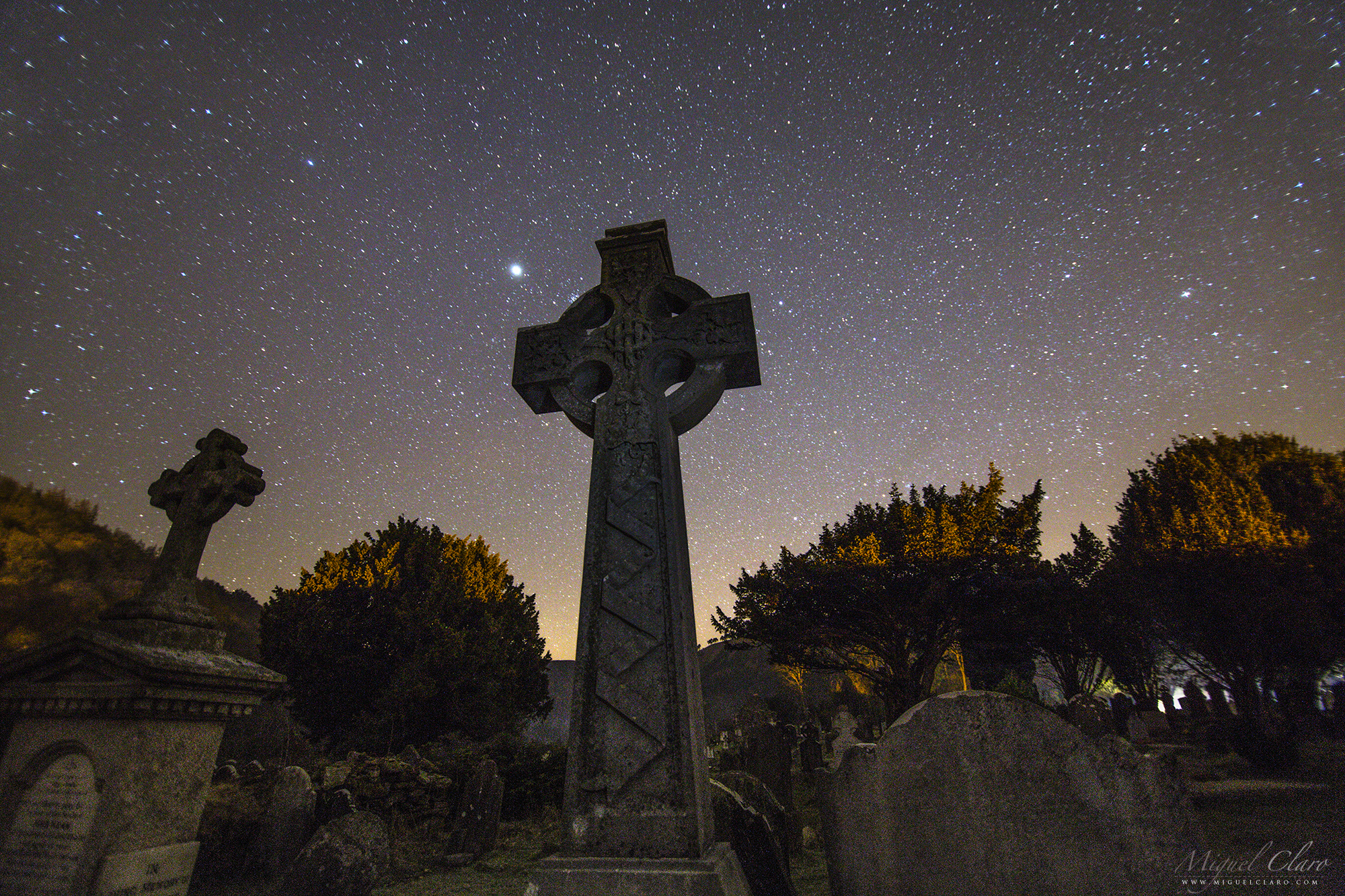
This Celtic Cross is a fine example of a plain cross remarkably carved from a single granite stone. The cross is the most ancient and powerful of symbols: an encounter of the vertical with the horizontal, the feminine & masculine, temporal & eternal. The circle of the Celtic cross, implying infinity, gives it a cosmic dimension. The arms of the cross are over a metre in length. The imperforate cross stands about 2.5m tall. It may have marked the boundary of the cemetery in which stands the priests’ house. This cross is a fine example of how St Patrick trying to help the once pagan people of Ireland acclimate to Christianity. This was done by combining the cross with the circle representing the sun, because the pagans worshipped the sun and moon. A local legend surrounding St. Kevin’s Cross says that anyone who can wrap their arms around the entire width of the cross body and close the circle by touching fingertips will have their wishes granted.
Glendalough (meaning “Valley of two lakes”) is a glacial valley in County Wicklow, Ireland, renowned for an Early Medieval monastic settlement founded in the 6th century by St Kevin. It combines extensive monastic ruins with a stunning natural setting in the Wicklow Mountains. The beauty and tranquility of the lakes and glacial-carved valley no doubt appealed to St Kevin, a hermit monk, who founded the monastic site near the Lower Lake in the 6th Century. Most of the buildings that survive today date from the 10th through 12th centuries. Despite attacks by Vikings over the years, Glendalough thrived as one of Irelands great ecclesiastical foundations and schools of learning until the Normans destroyed the monastery in 1214 and the dioceses of Glendalough and Dublin were united. The settlement was destroyed by English forces in 1398. A reconstruction program was started in 1878 and today the valley boasts a visitor centre, wooded trails, walkways and rock climbing. The monastic ruins include a round tower, seven churches, a gateway into the settlement with a Sanctuary Stone, two High Crosses, the priest’s house, a graveyard, Reeferts Church, St. Kevin’s Bed (Cave) and St. Kevin’s Cell (hermitage hut). More about.
PT: Esta cruz celta é um belo exemplo de uma cruz simples notavelmente esculpida de uma única pedra de granito. A cruz é o mais antiga e poderoso símbolo: um encontro do vertical com o horizontal, o feminino e masculino, temporal e eterno. O círculo da cruz celta, o que implica infinito, dá-lhe uma dimensão cósmica. Estas cruzes celtas podem ser encontradas no cemitério de Glendalough. Com o significado “Vale dos dois lagos”, é um vale glacial no condado de Wicklow, na Irlanda, conhecida por uma povoação monástica medieval precoce fundada no século 6 pelo St Kevin. Combina extensas ruínas monásticas com um cenário natural deslumbrante nas montanhas de Wicklow. A beleza e tranquilidade dos lagos e do vale glacial esculpido, sem dúvida, chamaram a atenção do monge eremita St Kevin . A maioria dos edifícios que sobreviveram até aos dias de hoje datam do século 12. Apesar dos ataques de Vikings ao longo dos anos, Glendalough prosperou como uma das grandes fundações eclesiásticas irlandesas e escolas de aprendizagem até que os normandos destruiram o mosteiro em 1214 e as dioceses de Glendalough e Dublin foram unidos. A liquidação foi destruída por forças inglesas em 1398. Um programa de reconstrução foi iniciado em 1878 e hoje o vale dispõe de um centro de visitantes, trilhas arborizadas, calçadas e escalada. As ruínas monásticas incluem uma torre redonda, sete igrejas, uma porta de entrada para a povoação com um Santuário de pedra, duas cruzes celtas altas, casa do padre e um cemitério.
If the Shadows Were Roots

EN: This full dome view show a blue sky filled with winter stars like Sirius or bright constellations like Orion, is illuminated by the Moonlight working as a perfect background to highlight the silhouette from the Giant Chestnut tree of Guilhafonso in Guarda, Portugal, while in the field, its projection creates the illusion like if the shadows were roots. This century-old tree is considered the largest of its kind in Europe. This is a specimen of 9.60 meters trunk circumference, 19 meters in height, average crown diameter of 25.5 meters and an estimated age of over 400 years. Residents ensure that they need at least nine people to embrace its trunk. In 2015 the giant chestnut won new liveliness after having been treated which allowed it to still giving chestnuts nowadays.
PT: Nesta imagem All Sky, um céu azul repleto de estrelas de inverno como Sirius ou constelações brilhantes como Orion, é iluminado pelo luar funcionando como o pano de fundo perfeito para destacar a imponente silhueta do Castanheiro Gigante de Guilhafonso, na Guarda, Portugal, enquanto a projecção das sombras em terra nos dá a ilusão como se as mesmas fossem as suas próprias raízes. Esta árvore centenária é considerada a maior da sua espécie na Europa. Trata-se de um espécime de 9,60 metros de perímetro de tronco, 19 metros de altura, diâmetro médio da copa de 25,5 metros e uma idade estimada em mais de 400 anos. Os residentes garantem que são precisas pelo menos nove pessoas para abraçar o seu tronco. Em 2015, depois de ter sido submetido a um tratamento, o castanheiro gigante ganhou nova vivacidade o que permitiu continuar dar nozes até aos dias de hoje.
The Giant Chestnut of Guilhafonso

EN: A blue sky filled with winter stars like Sirius or bright constellations like Orion, is illuminated by the Moonlight working as a perfect background to highlight the silhouette from the Giant Chestnut tree of Guilhafonso in Guarda, Portugal. This century-old tree is considered the largest of its kind in Europe. This is a specimen of 9.60 meters trunk circumference, 19 meters in height, average crown diameter of 25.5 meters and an estimated age of over 400 years. Residents ensure that they need at least nine people to embrace its trunk. In 2015 the giant chestnut won new liveliness after having been treated which allowed it to still giving chestnuts nowadays.
PT: Um céu azul repleto de estrelas de inverno como Sirius ou constelações brilhantes como Orion, é iluminada pelo luar funcionando como o pano de fundo perfeito para destacar a imponente silhueta do Castanheiro Gigante de Guilhafonso, na Guarda, Portugal. Esta árvore centenária é considerada a maior da sua espécie na Europa. Trata-se de um espécime de 9,60 metros de perímetro de tronco, 19 metros de altura, diâmetro médio da copa de 25,5 metros e uma idade estimada em mais de 400 anos. Os residentes garantem que são precisas pelo menos nove pessoas para abraçar o seu tronco. Em 2015, depois de ter sido submetido a um tratamento, o castanheiro gigante ganhou nova vivacidade o que permitiu continuar dar nozes até aos dias de hoje.
Startrail above chapel of Saint Kevin at Glendalough

Glendalough (meaning “Valley of two lakes”) is a glacial valley in County Wicklow, Ireland, renowned for an Early Medieval monastic settlement founded in the 6th century by St Kevin. It combines extensive monastic ruins with a stunning natural setting in the Wicklow Mountains. The beauty and tranquility of the lakes and glacial-carved valley no doubt appealed to St Kevin, a hermit monk, who founded the monastic site near the Lower Lake in the 6th Century. Most of the buildings that survive today date from the 10th through 12th centuries. Despite attacks by Vikings over the years, Glendalough thrived as one of Irelands great ecclesiastical foundations and schools of learning until the Normans destroyed the monastery in 1214 and the dioceses of Glendalough and Dublin were united. The settlement was destroyed by English forces in 1398. A reconstruction program was started in 1878 and today the valley boasts a visitor centre, wooded trails, walkways and rock climbing. The monastic ruins include a round tower, seven churches, a gateway into the settlement with a Sanctuary Stone, two High Crosses, the priest’s house, a graveyard, Reeferts Church, St. Kevin’s Bed (Cave) and St. Kevin’s Cell (hermitage hut). More about.
In the image we can see a startrail above the celtic church of St. Kevin’s. This church is unusual, it has a round tower or belfry with conical cap integrated with the church. Perhaps because of its small size, or the tower resembling a chimney, it is frequently called “St. Kevin’s kitchen.” The tower is three stories high. Some sources suggest that it was part of the original structure, others claim it originally had a nave only with an entrance at the west end. The upper part of the gable window can be seen above what became the chancel arch, when the chancel (now missing) and the sacristy were added later. The steep roof has corbelled stones, similar to that atSt.Doolagh’s Church in Dublin and St. Columb’s Housein Kells. It is supported internally by a semi-circular vault. The church had a wooden upper floor and access to the roof chamber was through an opening at the western end of the vault.
PT: Na imagem podemos ver um startrail acima da igreja celta de St. Kevin, em Glendalough, Irlanda. Esta incomum igreja tem uma torre redonda ou campanário com o tampão cónico integrado, sendo frequentemente apelidada de “cozinha de St. Kevin.
Prime Meridian Laser in Greenwich
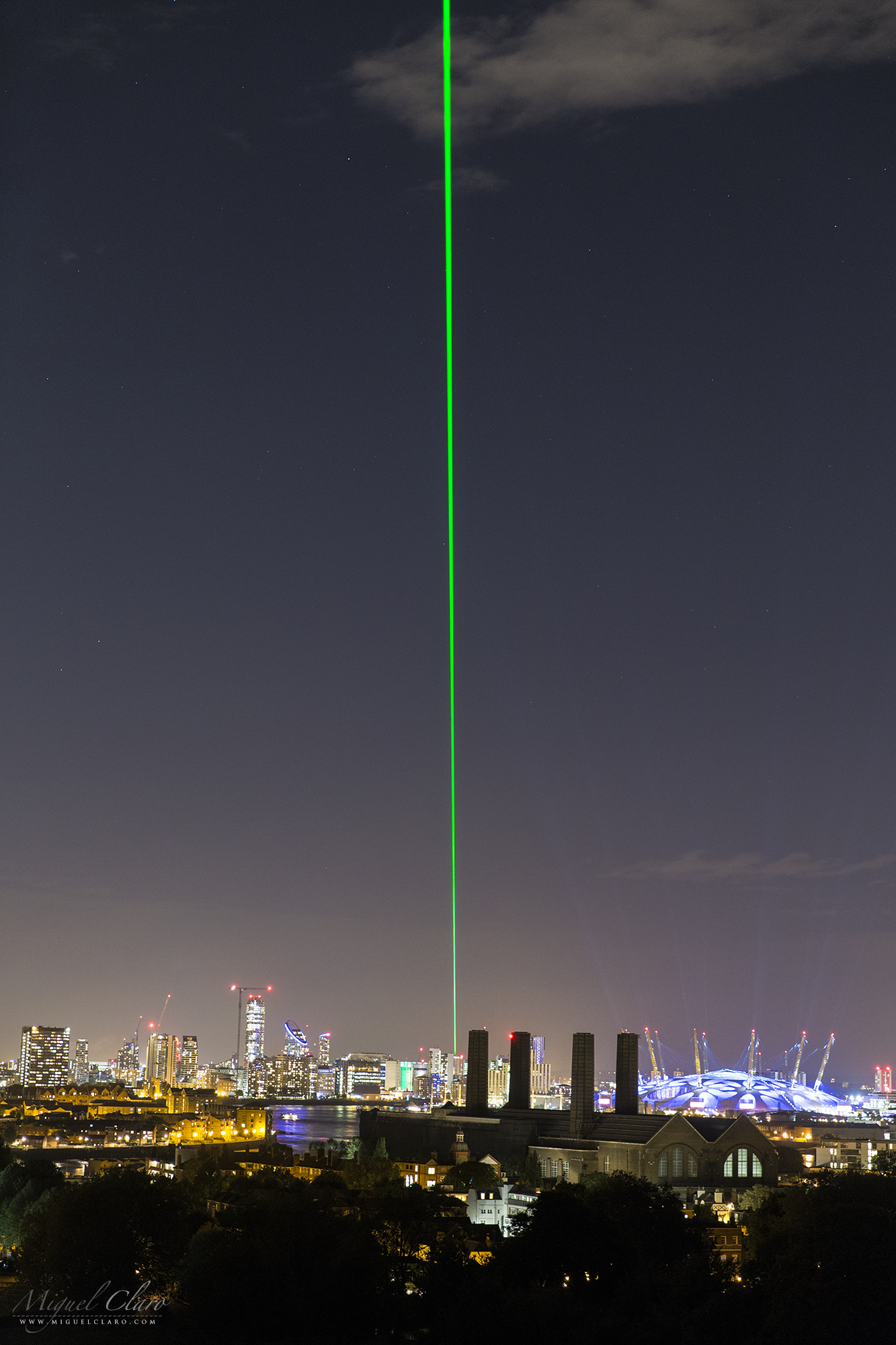
The Greenwich Meridian separates east from west in the same way that the Equator separates north from south. Inextricably linked with Greenwich Mean Time, it also sits at the centre of our system of time zones. Its path is determined by the location of an historic telescope, the Airy Transit Circle (51°28′40.1″N 0°0′5.3″W), which is housed at the Royal Observatory of Greenwich, in London. The Prime Meridian was established by Sir George Airy in 1851.
A prime meridian is a meridian (a line of longitude) in a geographical coordinate system at which longitude is defined to be 0°. Together, a prime meridian and its antimeridian (the 180th meridian in a 360°-system) form a great circle. This great circle divides the sphere, e.g., the Earth, into two hemispheres. If one uses directions of East and West from a defined prime meridian, then they can be called Eastern Hemisphere and Western Hemisphere.
PT: O meridiano de Greenwich separa “Este” de “Oeste” da mesma forma que o Equador separa o Norte do Sul. Intimamente ligado com Greenwich Mean Time, também está no centro do nosso sistema de fusos horários. O seu caminho é determinado pela localização de um telescópio histórico, o “Airy Transit Circle” (51°28′40.1″N 0°0′5.3″W), que está localizado no Observatório Real de Greenwich, em Londres. O Meridiano de Greenwich foi criada por Sir George Airy em 1851.
The Prime Meridian in Greenwich Observatory, was long marked by a brass strip in the courtyard, now replaced by stainless steel, and, since 16 December 1999, has been marked by a powerful green laser shining north across the London night sky. The Meridian laser marks the route of the Greenwich Meridian by night in a northerly direction from the Royal Observatory. Under good viewing conditions, it is visible at a distance of over 36 miles with the naked eye and over 60 miles with binoculars.
Summer Triangle above Vatican City State

The Summer Triangle is an astronomical asterism involving an imaginary triangle drawn on the northern hemisphere’s celestial sphere, with its defining vertices at Altair, Deneb, and Vega, the brightest stars in the three constellations of Aquila, Cygnus, and Lyra, respectively. Only this 3 stars are bright enough to be visible above the light polluted sky from the City State of Vaticano, in Rome, Italy.
Near midnight, the Summer Triangle lies virtually overhead at mid-northern latitudes during the summer months, but can also be seen during spring in the early morning to the East. In the autumn the summer triangle is visible in the evening to the West well until November. From the southern hemisphere it appears upside down and low in the sky during the winter months.
The Church has had a long-standing interest in astronomy, due to the astronomical basis of the calendar by which holy days and Easter are determined. For instance, the Gregorian Calendar, promulgated in 1582 by Pope Gregory XIII, was developed by Aloysius Lilius and later modified by Christoph Clavius at the Collegio Romano from astronomical data. The Gregorian Tower was completed in 1580 for his purpose, designed by Bolognese architect Ottaviano Matte.
The Vatican Observatory (Latin: Specola Vaticana) is an astronomical research and educational institution supported by the Holy See. Originally based in the Roman College of Rome, the Observatory is now headquartered in Castel Gandolfo, Italy and operates a telescope at the Mount Graham International Observatory in the United States. In the 18th century, the Papacy actively supported astronomy, establishing the Observatory of the Roman College in 1774. In 1789–1787, the Specola Vaticana in the Tower of the Winds within the Vatican was established under the direction of Msgr. Filippo Luigi Gilii (1756–1821). When Msgr. Gilii died, the Specola was closed down because it was inconvenient for students in the city because the dome of St. Peter’s obstructed its view. Its instruments were transferred to the College Observatory. A third facility, the Observatory of the Capitol, was operated from 1827 to 1870. In 1891, however, Pope Leo XIII issued a Motu Proprio re-founding the Specola Vaticana (Vatican Observatory) and a new observatory was built on the walls at the edge of the Vatican.The new Vatican Observatory remained there for the next forty years.
By the 1930s, the smoke and sky-glow of the city had made it impossible to conduct useful observations in Rome. Pope Pius XI relocated the Observatory to Castel Gandolfo, which is 25 kilometres (16 mi) southeast of Rome. By 1961, the same problems with light pollution made observing difficult at Castel Gandolfo. The Observatory then established the Vatican Observatory Research Group, with offices at the Steward Observatory of the University of Arizona in Tucson, Arizona.
PT: O Triângulo de Verão é um asterismo astronómico envolvendo um triângulo imaginário “desenhado na esfera celeste” do hemisfério norte, com os seus vértices a definirem Altair, Deneb e Vega, as estrelas mais brilhantes nas três constelações de Aquila, Cygnus e Lyra, respectivamente. Só estas 3 estrelas conseguem ser suficientemente brilhantes para serem visíveis a partir de um céu poluído como o que se ergue acima do Estado da Cidade do Vaticano, em Roma, Itália.

Officially called Vatican City State or the State of Vatican City is a walled enclave within the city of Rome. With an area of approximately 44 hectares (110 acres), and a population of 842, it is the smallest sovereign state in the world by both area and population. It is an ecclesiastical or sacerdotal-monarchical state (a type of theocracy) ruled by the Bishop of Rome – the Pope. The highest state functionaries are all Catholic clergy of various national origins. Since the return of the Popes from Avignon in 1377, they have generally resided at the Apostolic Palace within what is now Vatican City. Vatican City is distinct from the Holy See (Latin: Sancta Sedes), which dates back to early Christianity and is the main episcopal see of 1.2 billion Latin and Eastern Catholic adherents around the globe. The independent city-state, on the other hand, came into existence in 1929 by the Lateran Treaty between the Holy See and Italy, which spoke of it as a new creation, not as a vestige of the much larger Papal States (756–1870), which had previously encompassed much of central Italy. According to the terms of the treaty, the Holy See has “full ownership, exclusive dominion, and sovereign authority and jurisdiction” over the city-state.
Penumbral Lunar Eclipse in the Harvest Moon above Sesimbra Castle

On september 16h the disc of the moon has reached the 100% illumination exactly at the same time he was rising in the portuguese sky. This september Full Moon is known, according to folklore, as the Harvest Moon, “a bright orb that shines down on the ripening fields of the northern hemisphere, allowing farmers to harvest their crops late into the night”. Besides his normal brightness when it is Full, this particular Moon was a bit darker then normal, due to a penumbral lunar eclipse, that happens when the Moon passes through the pale outskirts of Earth’s shadow. It is much less dramatic than a total lunar eclipse. The final image is a sequence shot captured during 25 minutes, at the moonrise, with a 200mm lens at about 700 meters away from the Sesimbra Castle, in Portugal.
PT: Eclipse penumbral da Lua captada no dia 16 de Setembro. Nesta sequência de disparos combinada, é possível o nascer da Lua acima do Castelo de Sesimbra. Como o eclipse é penumbral, apenas a região superior da lua é ligeiramente escurecida pelo cone de sombra da terra.
Moon and Atomium Shpere

A 16% Crescent Moon between the UFO structure of Atomium, in Brussels, Belgium. The whole forms the shape of a unit cell of an iron crystal magnified 165 billion times, showing how small we are in this Universe, but at the same time, how big we are as a Humankind. Developing and increasing our skills, creating the capacity of constructing and doing big things on Earth. This can be the closest real view and the ideia that we have of an UFO spaceship, that has indeed, human life on board of these spheres.
EN: The Atomium is a building in Brussels originally constructed for Expo 58, the 1958 Brussels World’s Fair. Designed by the engineer André Waterkeyn and architects André and Jean Polak it stands 102 m (335 ft) tall. Its nine 18 m (59 ft) diameter stainless steel clad spheres are connected. The name is a combination of atom and aluminium. It is a museum. The whole thing is made up of 9 spheres (one at each of the 8 points and one in the middle) connected by 20 tubes (12 cube edges plus 2 tubes for the 4 diagonals): the structure rests on 3 pillars (or bipods). They enclose stairs, escalators and a lift (in the central, vertical tube) to allow access to the five habitable spheres which contain exhibit halls and other public spaces. A permanent exhibition dedicated to Expo 58 and temporary exhibitions devoted to architecture, design and society. It could be the closest ideia we have of an UFO spaceship, that has indeed, human life on board of these 5 spheres. MC
PT: O Atomium foi construído em 1958 em Bruxelas no âmbito da Expo 58. Com 102 metros de altura, o Atomium representa um cristal elementar de ferro ampliado 165 mil milhões de vezes, com tubos que ligam as 9 partes formando 8 vértices. As esferas de ferro com cerca de 18 metros de diâmetro estão ligadas por tubos com escadas no seu interior com um comprimento de cerca de 35 metros. As janelas instaladas na esfera do topo oferecem aos visitantes uma vista panorâmica da cidade. Outras esferas têm exposições sobre os anos 50. As três esferas, às quais só se tem acesso por tubos verticais, estão fechadas ao público por razões de segurança.
Atomium – An UFO Spaceship for Humanity

A 16% Crescent Moon between the UFO structure of Atomium, in Brussels, Belgium. The whole forms the shape of a unit cell of an iron crystal magnified 165 billion times, showing how small we are in this Universe, but at the same time, how big we are as a Humankind. Developing and increasing our skills, creating the capacity of constructing and doing big things on Earth. This can be the closest real view and the ideia that we have of an UFO spaceship, that has indeed, human life on board of these spheres.
EN: The Atomium is a building in Brussels originally constructed for Expo 58, the 1958 Brussels World’s Fair. Designed by the engineer André Waterkeyn and architects André and Jean Polak it stands 102 m (335 ft) tall. Its nine 18 m (59 ft) diameter stainless steel clad spheres are connected. The name is a combination of atom and aluminium. It is a museum. The whole thing is made up of 9 spheres (one at each of the 8 points and one in the middle) connected by 20 tubes (12 cube edges plus 2 tubes for the 4 diagonals): the structure rests on 3 pillars (or bipods). They enclose stairs, escalators and a lift (in the central, vertical tube) to allow access to the five habitable spheres which contain exhibit halls and other public spaces. A permanent exhibition dedicated to Expo 58 and temporary exhibitions devoted to architecture, design and society. It could be the closest ideia we have of an UFO spaceship, that has indeed, human life on board of these 5 spheres. MC
PT: O Atomium foi construído em 1958 em Bruxelas no âmbito da Expo 58. Com 102 metros de altura, o Atomium representa um cristal elementar de ferro ampliado 165 mil milhões de vezes, com tubos que ligam as 9 partes formando 8 vértices. As esferas de ferro com cerca de 18 metros de diâmetro estão ligadas por tubos com escadas no seu interior com um comprimento de cerca de 35 metros. As janelas instaladas na esfera do topo oferecem aos visitantes uma vista panorâmica da cidade. Outras esferas têm exposições sobre os anos 50. As três esferas, às quais só se tem acesso por tubos verticais, estão fechadas ao público por razões de segurança.
Moon Atomium

A 16% Crescent Moon between the UFO structure of Atomium, in Brussels, Belgium. The whole forms the shape of a unit cell of an iron crystal magnified 165 billion times, showing how small we are in this Universe, but at the same time, how big we are as a Humankind. Developing and increasing our skills, creating the capacity of constructing and doing big things on Earth. This can be the closest real view and the ideia that we have of an UFO spaceship, that has indeed, human life on board of these spheres.
EN: The Atomium is a building in Brussels originally constructed for Expo 58, the 1958 Brussels World’s Fair. Designed by the engineer André Waterkeyn and architects André and Jean Polak it stands 102 m (335 ft) tall. Its nine 18 m (59 ft) diameter stainless steel clad spheres are connected. The name is a combination of atom and aluminium. It is a museum. The whole thing is made up of 9 spheres (one at each of the 8 points and one in the middle) connected by 20 tubes (12 cube edges plus 2 tubes for the 4 diagonals): the structure rests on 3 pillars (or bipods). They enclose stairs, escalators and a lift (in the central, vertical tube) to allow access to the five habitable spheres which contain exhibit halls and other public spaces. A permanent exhibition dedicated to Expo 58 and temporary exhibitions devoted to architecture, design and society. It could be the closest ideia we have of an UFO spaceship, that has indeed, human life on board of these 5 spheres. MC
PT: O Atomium foi construído em 1958 em Bruxelas no âmbito da Expo 58. Com 102 metros de altura, o Atomium representa um cristal elementar de ferro ampliado 165 mil milhões de vezes, com tubos que ligam as 9 partes formando 8 vértices. As esferas de ferro com cerca de 18 metros de diâmetro estão ligadas por tubos com escadas no seu interior com um comprimento de cerca de 35 metros. As janelas instaladas na esfera do topo oferecem aos visitantes uma vista panorâmica da cidade. Outras esferas têm exposições sobre os anos 50. As três esferas, às quais só se tem acesso por tubos verticais, estão fechadas ao público por razões de segurança.
Perigee Earthshine and Planet Mercury above Lisbon City

Featured as NASA´s Astronomy Picture of the Day (APOD).
We use the term of “Super Moon” when the moon is at the Perigee, closer to Earth, which is not so rare, occurring 13 times this year 2016. But to our naked eyes we only notice that moon is indeed, larger in the sky (15% bigger and 30% brighter) when the moon is normally full, capturing our attention during this period. On April 7, the New Moon was at the Perigee, so in the day after, on April 8, with only 3% of the disc illuminated by the sunlight, it would be considered a Super Crescent Moon, a perfect moment to show up the Earthshine phenomenon described and drawn for the first time by Leonardo DaVinci 500 years ago.

In the lovely view captured 8.5km straight from Lisbon city, from Barreiro region, with a telephoto lens, we can see in nautical twilight a beautiful alignment between the Super Crescent Moon and the planet Mercury – the bright “star” located at the same line – only separated by 6º, an easy target to find thanks to the help of our natural satellite, standing in the background above the monument Christ the King and the 25 April bridge. Above on the image, are seen reflections of light pollution in the water of Tagus River. In that night, to wind was so strong that my local good friend and photographer Nuno Lopes, was holding the cargo cover all the time, trying to protect me and my equipment from the strong winds, while I was photographing the telephoto scene showed below. Both of my cameras and William Optics telescope, were assembled in the new Advanced Vixen Polarie portable mount.

Ursa Major & Ursa Minor above the Ruins of Roman City Ammaia

EN: The northern constellations Ursa Major (Big Dipper) and Ursa Minor – in a diffuse vision by a passing cloud – as seen from inside the remaining ruins of the Southern Gate Tower of the Roman City of Ammaia.
The Gradual consolidation of Roman power led to the establishment of a substantial Roman town in the 1st century. Ammaia occupied up to 25 hectares, and with a population exceeding modern-day Marvão (5000-6000 inhabitants) Ammaia occupied the site of the present-day parish of São Salvador da Aramenha. The town flourished between the 1st century BCE and the collapse of the Roman Empire in the 5th century CE. Roman Ammaia saw the development of improved irrigation and terracing across the Marvão mountain. Chestnut cultivation – Replacing the place dominance of oak is likely to have been introduced at this time. Much of the terracing and ancient watercourses on the mountain Marvão date from this era.
Limited excavations at Ammaia in the past two decades covering a mere 3,000 m2 (32.292 sq ft) of the town’s area – have revealed the success, provincial expanding town that included running water, a forum, baths, the bridge over the river Sever (near today’s ‘Old Bridge’), and monumental gates (one gate was removed to Castelo de Vide in the 18th century, yet sadly dynamited in 1890). The Alentejo region, meanwhile, was criss-crossed with efficient Roman roads, providing links to the wider Empire. Fine wares found at the site Ammaia suggest que Ammaia nobility had access to luxury glassware and jewelery, while archeology has Revealed that marble for the forum was imported from across the Empire. The high quality, for example, of the ‘Mosaic of the Muses’ from a Roman villa in nearby Monforte (4th century BCE) points to the abundant riches to be made to an Alentejo landowner in the Roman era. Sadly, many artifacts from Ammaia in particular the series of marble sculptures were removed during the 19th and 20th centuries, notably by the Anglo-Portuguese Robinson family. These items are now in collections such as those of the British Museum..
Many of the excavations were concentrated over the obvious ruins or where there was evidence of subterranean structures associated with a Roman presence. Discoveries include parts of a Roman city wall with towers and a gate on the south side, with residenctial buildings; a road; a monumental paved square; remains of a house in the location Quinta do Deão; parts of a public bath building; and a centrally-located forum with well-preserved temple podium, walls of a porticus and cryptoporticus. The town plan follows a regular rectangular layout organized along two main perpendicular street axes, linking the central forum to its main gates. A city wall surrounds a roughly rectangular area of some 20 hectares. Several extramural buildings, cemeteries and roads constitute the suburban area.
PT: As constelações do norte, Ursa Maior e Ursa Menor, numa visão difusa através de uma nuvem passageira, vistas a partir das imponentes ruínas da Porta Sul da cidade Romana da Ammaia. A Cidade de Ammaia é indubitavelmente o mais importante vestígio da sua época existente na região do norte alentejano. Localizada em pleno Parque Natural da Serra de São Mamede, em São Salvador de Aramenha, no concelho de Marvão, a sua área central é constituída pela Quinta do Deão e pela Tapada da Aramenha, possuindo uma área de aproximadamente 25 ha.
Embora as suas ruínas tivessem sido classificadas como Monumento Nacional em 1949, estiveram abandonadas até finais de 1994. A partir desta data e com o aparecimento da Fundação Cidade de Ammaia vêm-se desenvolvendo todos os esforços no sentido de estudar e preservar o que resta desta importante cidade. Ammaia foi elevada a Civitas por volta do ano 44/45 d.C. tendo obtido o estatuto de Mvnicipivm ainda durante o séc. I d.C., no entanto apenas temos dados sobre o mesmo no reinado de Lúcio Vero, no ano de 166 d.C.
A Northern Starry Trail from inside the Southern Gate of the Roman City of Ammaia

EN: A Polar Startrail from inside the remaining ruins of the Southern Gate Tower of the Roman City of Ammaia.
The Gradual consolidation of Roman power led to the establishment of a substantial Roman town in the 1st century. Ammaia occupied up to 25 hectares, and with a population exceeding modern-day Marvão (5000-6000 inhabitants) Ammaia occupied the site of the present-day parish of São Salvador da Aramenha. The town flourished between the 1st century BCE and the collapse of the Roman Empire in the 5th century CE. Roman Ammaia saw the development of improved irrigation and terracing across the Marvão mountain. Chestnut cultivation – Replacing the place dominance of oak is likely to have been introduced at this time. Much of the terracing and ancient watercourses on the mountain Marvão date from this era.
Limited excavations at Ammaia in the past two decades covering a mere 3,000 m2 (32.292 sq ft) of the town’s area – have revealed the success, provincial expanding town that included running water, a forum, baths, the bridge over the river Sever (near today’s ‘Old Bridge’), and monumental gates (one gate was removed to Castelo de Vide in the 18th century, yet sadly dynamited in 1890). The Alentejo region, meanwhile, was criss-crossed with efficient Roman roads, providing links to the wider Empire. Fine wares found at the site Ammaia suggest que Ammaia nobility had access to luxury glassware and jewelery, while archeology has Revealed that marble for the forum was imported from across the Empire. The high quality, for example, of the ‘Mosaic of the Muses’ from a Roman villa in nearby Monforte (4th century BCE) points to the abundant riches to be made to an Alentejo landowner in the Roman era. Sadly, many artifacts from Ammaia in particular the series of marble sculptures were removed during the 19th and 20th centuries, notably by the Anglo-Portuguese Robinson family. These items are now in collections such as those of the British Museum..
Many of the excavations were concentrated over the obvious ruins or where there was evidence of subterranean structures associated with a Roman presence. Discoveries include parts of a Roman city wall with towers and a gate on the south side, with residenctial buildings; a road; a monumental paved square; remains of a house in the location Quinta do Deão; parts of a public bath building; and a centrally-located forum with well-preserved temple podium, walls of a porticus and cryptoporticus. The town plan follows a regular rectangular layout organized along two main perpendicular street axes, linking the central forum to its main gates. A city wall surrounds a roughly rectangular area of some 20 hectares. Several extramural buildings, cemeteries and roads constitute the suburban area.
PT: Um vórtice de luz estrelar em torno da estrela Polar, a partir das imponentes ruínas da Porta Sul da cidade Romana da Ammaia. A Cidade de Ammaia é indubitavelmente o mais importante vestígio da sua época existente na região do norte alentejano. Localizada em pleno Parque Natural da Serra de São Mamede, em São Salvador de Aramenha, no concelho de Marvão, a sua área central é constituída pela Quinta do Deão e pela Tapada da Aramenha, possuindo uma área de aproximadamente 25 ha.
Embora as suas ruínas tivessem sido classificadas como Monumento Nacional em 1949, estiveram abandonadas até finais de 1994. A partir desta data e com o aparecimento da Fundação Cidade de Ammaia vêm-se desenvolvendo todos os esforços no sentido de estudar e preservar o que resta desta importante cidade. Ammaia foi elevada a Civitas por volta do ano 44/45 d.C. tendo obtido o estatuto de Mvnicipivm ainda durante o séc. I d.C., no entanto apenas temos dados sobre o mesmo no reinado de Lúcio Vero, no ano de 166 d.C.
The Monumental Paved Square from Roman City of Ammaia

EN: One of the remaining ruins from the monumental paved square of the Roman City of Ammaia, in a cloudy moonlight scene. Venus is the bright diffuse light below the right side of the moon.
The Gradual consolidation of Roman power led to the establishment of a substantial Roman town in the 1st century. Ammaia occupied up to 25 hectares, and with a population exceeding modern-day Marvão (5000-6000 inhabitants) Ammaia occupied the site of the present-day parish of São Salvador da Aramenha. The town flourished between the 1st century BCE and the collapse of the Roman Empire in the 5th century CE. Roman Ammaia saw the development of improved irrigation and terracing across the Marvão mountain. Chestnut cultivation – Replacing the place dominance of oak is likely to have been introduced at this time. Much of the terracing and ancient watercourses on the mountain Marvão date from this era.
Limited excavations at Ammaia in the past two decades covering a mere 3,000 m2 (32.292 sq ft) of the town’s area – have revealed the success, provincial expanding town that included running water, a forum, baths, the bridge over the river Sever (near today’s ‘Old Bridge’), and monumental gates (one gate was removed to Castelo de Vide in the 18th century, yet sadly dynamited in 1890). The Alentejo region, meanwhile, was criss-crossed with efficient Roman roads, providing links to the wider Empire. Fine wares found at the site Ammaia suggest que Ammaia nobility had access to luxury glassware and jewelery, while archeology has Revealed that marble for the forum was imported from across the Empire. The high quality, for example, of the ‘Mosaic of the Muses’ from a Roman villa in nearby Monforte (4th century BCE) points to the abundant riches to be made to an Alentejo landowner in the Roman era. Sadly, many artifacts from Ammaia in particular the series of marble sculptures were removed during the 19th and 20th centuries, notably by the Anglo-Portuguese Robinson family. These items are now in collections such as those of the British Museum..
Many of the excavations were concentrated over the obvious ruins or where there was evidence of subterranean structures associated with a Roman presence. Discoveries include parts of a Roman city wall with towers and a gate on the south side, with residenctial buildings; a road; a monumental paved square; remains of a house in the location Quinta do Deão; parts of a public bath building; and a centrally-located forum with well-preserved temple podium, walls of a porticus and cryptoporticus. The town plan follows a regular rectangular layout organized along two main perpendicular street axes, linking the central forum to its main gates. A city wall surrounds a roughly rectangular area of some 20 hectares. Several extramural buildings, cemeteries and roads constitute the suburban area.
PT: Uma noite de luar envolta na neblina que circunda as imponentes ruínas da praça pública pavimentada com blocos de granito, da cidade Romana da Ammaia. À direita da Lua, é possível ver o brilho difuso do planeta Vénus. A Cidade de Ammaia é indubitavelmente o mais importante vestígio da sua época existente na região do norte alentejano. Localizada em pleno Parque Natural da Serra de São Mamede, em São Salvador de Aramenha, no concelho de Marvão, a sua área central é constituída pela Quinta do Deão e pela Tapada da Aramenha, possuindo uma área de aproximadamente 25 ha.
Embora as suas ruínas tivessem sido classificadas como Monumento Nacional em 1949, estiveram abandonadas até finais de 1994. A partir desta data e com o aparecimento da Fundação Cidade de Ammaia vêm-se desenvolvendo todos os esforços no sentido de estudar e preservar o que resta desta importante cidade. Ammaia foi elevada a Civitas por volta do ano 44/45 d.C. tendo obtido o estatuto de Mvnicipivm ainda durante o séc. I d.C., no entanto apenas temos dados sobre o mesmo no reinado de Lúcio Vero, no ano de 166 d.C.
The Starry Sky from Roman City of Ammaia

EN: One of the remaining ruins from the Southern Gate Tower of the Roman City of Ammaia, in a cloudy moonlight scene.
The Gradual consolidation of Roman power led to the establishment of a substantial Roman town in the 1st century. Ammaia occupied up to 25 hectares, and with a population exceeding modern-day Marvão (5000-6000 inhabitants) Ammaia occupied the site of the present-day parish of São Salvador da Aramenha. The town flourished between the 1st century BCE and the collapse of the Roman Empire in the 5th century CE. Roman Ammaia saw the development of improved irrigation and terracing across the Marvão mountain. Chestnut cultivation – Replacing the place dominance of oak is likely to have been introduced at this time. Much of the terracing and ancient watercourses on the mountain Marvão date from this era.
Limited excavations at Ammaia in the past two decades covering a mere 3,000 m2 (32.292 sq ft) of the town’s area – have revealed the success, provincial expanding town that included running water, a forum, baths, the bridge over the river Sever (near today’s ‘Old Bridge’), and monumental gates (one gate was removed to Castelo de Vide in the 18th century, yet sadly dynamited in 1890). The Alentejo region, meanwhile, was criss-crossed with efficient Roman roads, providing links to the wider Empire. Fine wares found at the site Ammaia suggest que Ammaia nobility had access to luxury glassware and jewelery, while archeology has Revealed that marble for the forum was imported from across the Empire. The high quality, for example, of the ‘Mosaic of the Muses’ from a Roman villa in nearby Monforte (4th century BCE) points to the abundant riches to be made to an Alentejo landowner in the Roman era. Sadly, many artifacts from Ammaia in particular the series of marble sculptures were removed during the 19th and 20th centuries, notably by the Anglo-Portuguese Robinson family. These items are now in collections such as those of the British Museum..
Many of the excavations were concentrated over the obvious ruins or where there was evidence of subterranean structures associated with a Roman presence. Discoveries include parts of a Roman city wall with towers and a gate on the south side, with residenctial buildings; a road; a monumental paved square; remains of a house in the location Quinta do Deão; parts of a public bath building; and a centrally-located forum with well-preserved temple podium, walls of a porticus and cryptoporticus. The town plan follows a regular rectangular layout organized along two main perpendicular street axes, linking the central forum to its main gates. A city wall surrounds a roughly rectangular area of some 20 hectares. Several extramural buildings, cemeteries and roads constitute the suburban area.

PT: Uma noite de luar envolta na neblina que circunda as importantes e imponentes ruínas da Porta Sul da cidade Romana da Ammaia. A Cidade de Ammaia é indubitavelmente o mais importante vestígio da sua época existente na região do norte alentejano. Localizada em pleno Parque Natural da Serra de São Mamede, em São Salvador de Aramenha, no concelho de Marvão, a sua área central é constituída pela Quinta do Deão e pela Tapada da Aramenha, possuindo uma área de aproximadamente 25 ha.
Embora as suas ruínas tivessem sido classificadas como Monumento Nacional em 1949, estiveram abandonadas até finais de 1994. A partir desta data e com o aparecimento da Fundação Cidade de Ammaia vêm-se desenvolvendo todos os esforços no sentido de estudar e preservar o que resta desta importante cidade. Ammaia foi elevada a Civitas por volta do ano 44/45 d.C. tendo obtido o estatuto de Mvnicipivm ainda durante o séc. I d.C., no entanto apenas temos dados sobre o mesmo no reinado de Lúcio Vero, no ano de 166 d.C.
ISS Crossing the Skies of the Roman City Ammaia

EN: One of the remaining ruins from the Southern Gate Tower of the Roman City of Ammaia, in a cloudy moonlight scene, during the passage of the International Space Station above the skies. At the right side of the moon it is visible the planet Venus.
The Gradual consolidation of Roman power led to the establishment of a substantial Roman town in the 1st century. Ammaia occupied up to 25 hectares, and with a population exceeding modern-day Marvão (5000-6000 inhabitants) Ammaia occupied the site of the present-day parish of São Salvador da Aramenha. The town flourished between the 1st century BCE and the collapse of the Roman Empire in the 5th century CE. Roman Ammaia saw the development of improved irrigation and terracing across the Marvão mountain. Chestnut cultivation – Replacing the place dominance of oak is likely to have been introduced at this time. Much of the terracing and ancient watercourses on the mountain Marvão date from this era.
Limited excavations at Ammaia in the past two decades covering a mere 3,000 m2 (32.292 sq ft) of the town’s area – have revealed the success, provincial expanding town that included running water, a forum, baths, the bridge over the river Sever (near today’s ‘Old Bridge’), and monumental gates (one gate was removed to Castelo de Vide in the 18th century, yet sadly dynamited in 1890). The Alentejo region, meanwhile, was criss-crossed with efficient Roman roads, providing links to the wider Empire. Fine wares found at the site Ammaia suggest que Ammaia nobility had access to luxury glassware and jewelery, while archeology has Revealed that marble for the forum was imported from across the Empire. The high quality, for example, of the ‘Mosaic of the Muses’ from a Roman villa in nearby Monforte (4th century BCE) points to the abundant riches to be made to an Alentejo landowner in the Roman era. Sadly, many artifacts from Ammaia in particular the series of marble sculptures were removed during the 19th and 20th centuries, notably by the Anglo-Portuguese Robinson family. These items are now in collections such as those of the British Museum..
Many of the excavations were concentrated over the obvious ruins or where there was evidence of subterranean structures associated with a Roman presence. Discoveries include parts of a Roman city wall with towers and a gate on the south side, with residenctial buildings; a road; a monumental paved square; remains of a house in the location Quinta do Deão; parts of a public bath building; and a centrally-located forum with well-preserved temple podium, walls of a porticus and cryptoporticus. The town plan follows a regular rectangular layout organized along two main perpendicular street axes, linking the central forum to its main gates. A city wall surrounds a roughly rectangular area of some 20 hectares. Several extramural buildings, cemeteries and roads constitute the suburban area.
PT: Uma noite de luar envolta na neblina que circunda as importantes e imponentes ruínas da Porta Sul da cidade Romana da Ammaia, enquanto a Estação Espacial Internacional atravessa os céus da região. Logo abaixo da Lua, é ainda possível ver o brilho arrastado do planeta Vénus. A Cidade de Ammaia é indubitavelmente o mais importante vestígio da sua época existente na região do norte alentejano. Localizada em pleno Parque Natural da Serra de São Mamede, em São Salvador de Aramenha, no concelho de Marvão, a sua área central é constituída pela Quinta do Deão e pela Tapada da Aramenha, possuindo uma área de aproximadamente 25 ha.
Embora as suas ruínas tivessem sido classificadas como Monumento Nacional em 1949, estiveram abandonadas até finais de 1994. A partir desta data e com o aparecimento da Fundação Cidade de Ammaia vêm-se desenvolvendo todos os esforços no sentido de estudar e preservar o que resta desta importante cidade. Ammaia foi elevada a Civitas por volta do ano 44/45 d.C. tendo obtido o estatuto de Mvnicipivm ainda durante o séc. I d.C., no entanto apenas temos dados sobre o mesmo no reinado de Lúcio Vero, no ano de 166 d.C.
Ruins from the Roman City of Ammaia

EN: One of the remaining ruins from the Southern Gate Tower of the Roman City of Ammaia, in a cloudy moonlight scene.
The Gradual consolidation of Roman power led to the establishment of a substantial Roman town in the 1st century. Ammaia occupied up to 25 hectares, and with a population exceeding modern-day Marvão (5000-6000 inhabitants) Ammaia occupied the site of the present-day parish of São Salvador da Aramenha. The town flourished between the 1st century BCE and the collapse of the Roman Empire in the 5th century CE. Roman Ammaia saw the development of improved irrigation and terracing across the Marvão mountain. Chestnut cultivation – Replacing the place dominance of oak is likely to have been introduced at this time. Much of the terracing and ancient watercourses on the mountain Marvão date from this era.
Limited excavations at Ammaia in the past two decades covering a mere 3,000 m2 (32.292 sq ft) of the town’s area – have revealed the success, provincial expanding town that included running water, a forum, baths, the bridge over the river Sever (near today’s ‘Old Bridge’), and monumental gates (one gate was removed to Castelo de Vide in the 18th century, yet sadly dynamited in 1890). The Alentejo region, meanwhile, was criss-crossed with efficient Roman roads, providing links to the wider Empire. Fine wares found at the site Ammaia suggest que Ammaia nobility had access to luxury glassware and jewelery, while archeology has Revealed that marble for the forum was imported from across the Empire. The high quality, for example, of the ‘Mosaic of the Muses’ from a Roman villa in nearby Monforte (4th century BCE) points to the abundant riches to be made to an Alentejo landowner in the Roman era. Sadly, many artifacts from Ammaia in particular the series of marble sculptures were removed during the 19th and 20th centuries, notably by the Anglo-Portuguese Robinson family. These items are now in collections such as those of the British Museum..
Many of the excavations were concentrated over the obvious ruins or where there was evidence of subterranean structures associated with a Roman presence. Discoveries include parts of a Roman city wall with towers and a gate on the south side, with residenctial buildings; a road; a monumental paved square; remains of a house in the location Quinta do Deão; parts of a public bath building; and a centrally-located forum with well-preserved temple podium, walls of a porticus and cryptoporticus. The town plan follows a regular rectangular layout organized along two main perpendicular street axes, linking the central forum to its main gates. A city wall surrounds a roughly rectangular area of some 20 hectares. Several extramural buildings, cemeteries and roads constitute the suburban area.
PT: Uma noite de luar envolta na neblina que circunda as importantes e imponentes ruínas da Porta Sul da cidade Romana da Ammaia. A Cidade de Ammaia é indubitavelmente o mais importante vestígio da sua época existente na região do norte alentejano. Localizada em pleno Parque Natural da Serra de São Mamede, em São Salvador de Aramenha, no concelho de Marvão, a sua área central é constituída pela Quinta do Deão e pela Tapada da Aramenha, possuindo uma área de aproximadamente 25 ha.
Embora as suas ruínas tivessem sido classificadas como Monumento Nacional em 1949, estiveram abandonadas até finais de 1994. A partir desta data e com o aparecimento da Fundação Cidade de Ammaia vêm-se desenvolvendo todos os esforços no sentido de estudar e preservar o que resta desta importante cidade. Ammaia foi elevada a Civitas por volta do ano 44/45 d.C. tendo obtido o estatuto de Mvnicipivm ainda durante o séc. I d.C., no entanto apenas temos dados sobre o mesmo no reinado de Lúcio Vero, no ano de 166 d.C.
Waking Dream in the Magical Castle of Noudar

EN: At dawn the stars disappear, only the Moon survives and the sky becomes the canvas that will receive the brushstrokes of vivid colors and nuances that only the mastery of nature, can produce | Sky of Barrancos
PT: Ao amanhecer as estrelas perdem-se, só a Lua sobrevive e o céu torna-se a tela que recebes as pinceladas de cores vivas e nuances que só a mestria da natureza consegue produzir | Céu de Barrancos
Dragged Milky Way above the Historical Tower of Esporão
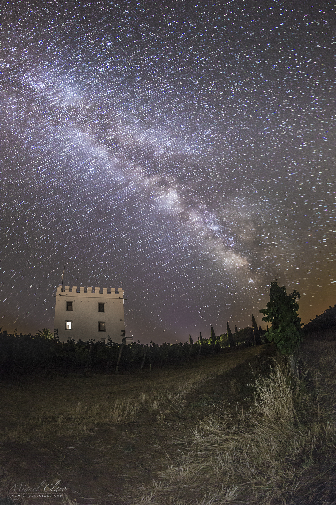
EN: Milky Way from the Esporão Tower, considered one of the most important towers built during the transition from the Middle Ages to the Modern Age | Sky of Reguengos de Monsaraz
PT: A Via Láctea a partir da Torre do Esporão, considerada como uma das mais importantes torres construídas na passagem da Idade Média para a Idade Moderna | Céu de Reguengos de Monsaraz
Endovelicus Startrail

EN: Endovelicus sanctuary of Rocha da Mina, in a winter sky by the moonlight, which highlights the constellation of Orion and the star Sirius, the brightest of the celestial sphere (left image) and a startrail pointing north (right image). Endovelicus was a solar healing supreme god, thus a god of Medicine.
PT: Santuário Endovélico Rocha da Mina num céu de inverno ao luar, de onde se destaca a constelação de Orion e a estrela Sirius, a mais brilhante da esfera celeste (imagens esquerda) e um rasto de estrelas a norte (imagem direita). Endovélico é uma divindade da Idade do Ferro venerada na Lusitânia pré-romana, deus da medicina, tinha um carácter simultaneamente solar | Céu do Alandroal
The Cult of Fertility

EN: Crescent moon against a twilight in Menhir Rocha dos Namorados, a natural granite outcrop mushroom-shaped, where single women throw back a stone which aims to fall on top of it, a cult related to fertility | Sky of São Pedro do Corral
PT: Lua crescente de um crepúsculo no Menir da Rocha dos Namorados, um afloramento natural de granito em forma de cogumelo, onde as mulheres solteiras lançam de costas uma pedra que tem por objectivo cair em cima do mesmo, num culto relacionado com a fecundidade | Céu de São Pedro do Corval
Orion in the Moonlight above Endovelicus Sanctuary of Rocha da Mina

EN: Endovelicus sanctuary of Rocha da Mina, in a winter sky by the moonlight, which highlights the constellation of Orion and the star Sirius, the brightest of the celestial sphere (left image) and a startrail pointing north (right image). Endovelicus was a solar healing supreme god, thus a god of Medicine.
PT: Santuário Endovélico Rocha da Mina num céu de inverno ao luar, de onde se destaca a constelação de Orion e a estrela Sirius, a mais brilhante da esfera celeste (imagens esquerda) e um rasto de estrelas a norte (imagem direita). Endovélico é uma divindade da Idade do Ferro venerada na Lusitânia pré-romana, deus da medicina, tinha um carácter simultaneamente solar | Céu do Alandroal
Milky Way dragged above the historical chapel of Esporão

EN:A milky dragged in the sky that rises above the chapel of Nossa Senhora dos Remédios, in the historic part of Esporão homestead | Sky of Reguengos de Monsaraz
PT: Uma via láctea arrastada no céu que se ergue acima da Ermida de Nossa Senhora dos Remédios, na zona histórica da Herdade do Esporão | Céu de Reguengos de Monsaraz
Galactic center above megalithic monument of Xerez

Central region of the Milky Way in the background of Cromeleque do Xerez, a megalithic monument consists of 50 granite menhirs erected between the 3rd and 4th millennium BC. 21/04/2015. Monsaraz | Alqueva Dark Sky Reserve – Portugal!
Milky Way Arch above Xerez Cromlech

Panoramic view of our own galaxy, the Milky Way arm as a background of Cromeleque do Xerez. 18/06/2015. Monsaraz | Alqueva Dark Sky Reserve – Portugal
The evolution of man from prehistoric times

View from inside the Dolmen of Olival da Pega, a human silhouette represents the evolution of man from prehistoric times, the heavens contemplation and the importance of astronomy, as the oldest science in the world. 21/04/2015. Telheiro | Alqueva Dark Sky Reserve – Portugal
A natural sundial

The megalith menhir of Bulhoa projecting its shadow in the lands of Telheiro, against a sunlight, which seems to function as a natural sundial. 18/06/2015. Telheiro | Alqueva Dark Sky Reserve – Portugal
Lunar Earthshine and the ancient olive tree

Lunar Earthshine in nautical twilight behind an ancient olive tree, with an age estimated between 2000 to 3000 years. 20/04/2015 Monsaraz | Alqueva Dark Sky Reserve – Portugal
1% of Crescent Moon above the Medieval Village of Monsaraz

The Crescent Moon with 1% of light, lying behind the castle and medieval village of Monsaraz. 19/04/2015 Monsaraz | Alqueva Dark Sky Reserve – Portugal
Supermoon 2015 from Medieval Village of Monsaraz

Image of the first biggest and brightest full Moon of the year 2015, captured on August 29. Astronomers call it a perigee moon, but the popular term is “supermoon.” The image was captured in Alqueva Dark Sky Reserve, Portugal, at a distant of about 4km from the medieval village and castle of Monsaraz on 29/08/2015. Two combined exposures taken at approximately the same time with a Canon 6D – ISO2000; Exp. 1/125 secs. f/7 at 560mm ( Astro Professional APO ED80).
The Precession of Earth – New Photo Technique showing a Vega Polar Startrail.

Featured as NASA´s Astronomy Picture of the Day (APOD).
Since the very first moment I read and learned about the Precession of Earth that I was fascinated with the possibility of having a different star than Polaris, pointing to north, although in that time, few years ago, I didn’t had the right technology and even the chance to could show in a real image how it would be…how would be the sky of my land if I had another star in the place of the well known, Polaris ?
After a long time of burning my mind with some new ideias, I figured out how I could do it, developing what I think is, a totally new astrophotographic technique never applied before, and where I can show in real time the sky rotating around another star, simulating the shifting of Earth Axis even being inside our Earth.
In astronomy, axial precession is a gravity-induced, slow, and continuous change in the orientation of an astronomical body’s rotational axis. In particular, it refers to the gradual shift in the orientation of Earth’s axis of rotation, which, similar to a wobbling top, traces out a pair of cones joined at their apices in a cycle of approximately 26,000 years.
A consequence of the precession is a changing pole star. Currently, Polaris is extremely well suited to mark the position, as Polaris is a moderately bright star located about 0,7º degrees from the pole. But with the crescent light pollution is Increasingly difficult to distinguish the few bright stars in the middle of cities, so near the year 14 000, the brilliant Vega in the constellation Lyra, is touted as the best north star. Although, it never comes closer than 5° to the celestial pole.
When Polaris becomes the north star again around 27,800, due to its proper motion it then will be farther away from the pole than it is now, while in 23,600 BC it came closer to the pole.
What I did to create the both startrails and time lapse images, was to use 2 mountings Vixen Polarie, one to pointing to the actual Polaris Axis and making all the stars staying fixed, but using another Polarie attached to the first one, I could simulate again the Earth Axis Rotation using the sideral motion inverted (I mean, like if I was in the south pole, near the batteries you can switch the button to (N) north or (S) south motion).
But I had special carefully with some things. I have waited until Vega star reach the same altitude I had in my observing latitude, in my case 38º, to have the same distance to the horizon that I have when looking to Polaris.
Very Important: The second condition to give the right movement, was to align carefully the star Vega near the center of the image (my new Earth Axis – now a Vixen Polarie Axis), to create the axis rotation simulating the 5º separation of the celestial north in +14000 (year). I also used the Live View magnifier with the grid option to have a more precise result.
*Important Note: Precession changes the direction of the Earth axis from Polaris to Vega on the celestial sphere, but the positions where the axis crosses the surface of Earth will not change by precession. So the north on the Earth from the observation point will not change, and the latitude of the observation point will not change too. Although, I choose the option that includes “apparently” almost the same landscape field view and where fits both Polaris (at left) and Vega (center), because if I had putting the Polaris in the same central framing position, as I did with Vega ( remembering that is the only possible way – as a condition – to simulating the Earth Axis rotation using the Vixen Polarie sideral motion, and show nowadays, the motion of the stars around Vega in a real Time Lapse movie sequence), I would loose the same landscape field of view with the Castle Tower, and this was also important to give people the notion that the image was really made in the same place. Vega is about 51º away from Polaris, so it means a big change in the field of view towards another position in the sky and consequently, in the landscape, in this case towards left, to Azimuth 0º – North, where stand the Polaris star.
As this technique induces movement, the landscape will move a bit from the first frame to the last one, but in the final startrail “still image”, I made a mask merging the landscape with the first frame again to have a more pleasant result.
All the images were taken from inside the Mourão Castle, in the Dark Sky Alqueva Reserve, the First Starlight Tourism Destination in the world, in Alentejo, Portugal.

Technical info:
Polaris Startrail starts in 19/04/2015 at 23h48 and Vega startrail starts in 20/04/2015 at 1:07
Canon EOS 6D – Canon EF 8-15 f/ 4L Fishseye USM at 8mm (All Sky). Exp. 30 sec. ISO 2500
Enjoying Venus corona above the Giant´s Causeway – Northen Ireland

In the image we can see a Skygazer enjoying the planet venus with a visible corona phenomenon between the Giant’s Causeway, near Bushmills, in northeast coast of Northen Ireland. Is an area of about 40,000 interlocking basalt columns, the result of an ancient volcanic eruption, 60 million years ago. It was declared a World Heritage Site byUNESCO in 1986. Near the top edge of the image we can see the Pleiades star cluster.
Corona, is produced by the diffraction of light from either the Sun, the Moon or some bright planets by individual small water droplets and sometimes tiny ice crystals of a cloud.
ISO 2000, 30 sec, 16mm at f/2.8. In 20/03/2015 at 20:17
Moonrise in Monsaraz Castle

EN: Full Moonrise behind the medieval village and castle of Monsaraz | Sky of Monsaraz
PT: Nascer da lua cheia por detrás da vila e castelo medieval de Monsaraz | Céu de Monsaraz
Dragged Milky Way in the Church of Noudar

A dragged Milky Way behind the Church of Noudar Castle, called: Igreja Nossa Senhora do Desterro.
Included in the great Alqueva Dark Sky Reserve – first site in the world to receive the “Starlight Tourism Destination” certification – Noudar Natural Park is located in a farm estate called Herdade da Coitadinha spreads across 1000 hectare, ‘over-the-hills’ between the winding rivers Ardila and Múrtega and lodged among hills and summits near the town of Barrancos (Alentejo, Portugal) and in the border with Spain. The road from the Park’s entrance to the Noudar Castle goes through an extensive holm oak grove (‘montado’) area, ending with a majestic view over the water lines. In Noudar, life presents itself in a state of wilderness and absolute purity.
The Castle of Noudar and the church of Nossa Senhora do Desterro is located between the Múrtega and the Ardila rivers which flow towards the West. Its construction was finished in 1307, during the reign of Don Dinis. The place was chosen because of its natural defenses, easy access and the closeness of a water spring of excellent quality – Fonte da Figueira, located roughly 250 meters to the East of the castle, under the hilltop known as Forca (“the Gallows”). Good and plentiful farming land and cattle grazing fields can also be found near the castle. This medieval fortress was very important for border defense against the kingdom of Castile during the early 14th Century.
More about Alqueva Dark Sky Reserve: Alqueva is the first site in the world to receive the “Starlight Tourism Destination” certification. This certification, awarded by the Starlight Foundation is supported by UNESCO, UNWTO and IAC. Starlight destinations are visitable places characterized by excellent quality for the contemplation of starry skies, and the practice of tourist activities based on this resource. www.darkskyalqueva.com
* This “comet effect” in the stars is not natural and not visible in the sky and it is only showed here for an artistic purpose.
PT: O arrasto da Via Láctea na igreja de Noudar, numa última aparição em forma de despedida antes de dar início o inverno | Céu de Barrancos
The Cathedral of Évora with a Moon Green Flash

In this picture captured from Évora, we can see the Moon rise one day after it reach is fullness. This first Full Moon of the year is well known as the Wolf Moon. At the left and in comparing with this big Moon captured with a 560mm telescope 2.4km away from the local, we can see the top of Évora´s Cathedral (Portuguese: Sé de Évora), that is one of the oldest and most important monuments in the city of Évora, declared a World Heritage Site by UNESCO in 1988. Dated from 12th century, It is the largest of the mediaeval cathedrals in Portugal, and one of its best examples of Gothic architecture. Regarding this almost Full Moon, we can see a top dispersion that creates normally a green rim. But a more powerful mirage seems to vertically magnified the rim into a green flash, visible in the top limb of the Moon.
More info about a Green Rim: http://www.atoptics.co.uk/atoptics/gf15.htm | Canon 50D – ISO1600; Exp. 1/10 secs. f/7 at 560mm ( Astro Professional APO ED80) single exposure taken in 05/01/2015 at 18h14m.
Around the Tower of Noudar Castle

A northen startrail around the Tower of Noudar Castle. The Polaris is hiden behind the walls of the Castle.
Included in the great Alqueva Dark Sky Reserve – first site in the world to receive the “Starlight Tourism Destination” certification – Noudar Natural Park is located in a farm estate called Herdade da Coitadinha spreads across 1000 hectare, ‘over-the-hills’ between the winding rivers Ardila and Múrtega and lodged among hills and summits near the town of Barrancos (Alentejo, Portugal) and in the border with Spain. The road from the Park’s entrance to the Noudar Castle goes through an extensive holm oak grove (‘montado’) area, ending with a majestic view over the water lines. In Noudar, life presents itself in a state of wilderness and absolute purity.
The Castle of Noudar and the church of Nossa Senhora do Desterro is located between the Múrtega and the Ardila rivers which flow towards the West. Its construction was finished in 1307, during the reign of Don Dinis. The place was chosen because of its natural defenses, easy access and the closeness of a water spring of excellent quality – Fonte da Figueira, located roughly 250 meters to the East of the castle, under the hilltop known as Forca (“the Gallows”). Good and plentiful farming land and cattle grazing fields can also be found near the castle. This medieval fortress was very important for border defense against the kingdom of Castile during the early 14th Century.
More about Alqueva Dark Sky Reserve:
Alqueva is the first site in the world to receive the “Starlight Tourism Destination” certification. This certification, awarded by the Starlight Foundation is supported by UNESCO, UNWTO and IAC. Starlight destinations are visitable places characterized by excellent quality for the contemplation of starry skies, and the practice of tourist activities based on this resource. www.darkskyalqueva.com
Milky Way from the Noudar Castle

Milky Way as viewed from the Noudar Castle. | Canon 60Da – ISO2500 Exp. 30 Secs. 11mm at f/2.8 taken in 20/10/2014 at 20h50m
Included in the great Alqueva Dark Sky Reserve – first site in the world to receive the “Starlight Tourism Destination” certification – Noudar Natural Park is located in a farm estate called Herdade da Coitadinha spreads across 1000 hectare, ‘over-the-hills’ between the winding rivers Ardila and Múrtega and lodged among hills and summits near the town of Barrancos (Alentejo, Portugal) and in the border with Spain. The road from the Park’s entrance to the Noudar Castle goes through an extensive holm oak grove (‘montado’) area, ending with a majestic view over the water lines. In Noudar, life presents itself in a state of wilderness and absolute purity.
The Castle of Noudar and the church of Nossa Senhora do Desterro is located between the Múrtega and the Ardila rivers which flow towards the West. Its construction was finished in 1307, during the reign of Don Dinis. The place was chosen because of its natural defenses, easy access and the closeness of a water spring of excellent quality – Fonte da Figueira, located roughly 250 meters to the East of the castle, under the hilltop known as Forca (“the Gallows”). Good and plentiful farming land and cattle grazing fields can also be found near the castle. This medieval fortress was very important for border defense against the kingdom of Castile during the early 14th Century.
More about Alqueva Dark Sky Reserve:
Alqueva is the first site in the world to receive the “Starlight Tourism Destination” certification. This certification, awarded by the Starlight Foundation is supported by UNESCO, UNWTO and IAC. Starlight destinations are visitable places characterized by excellent quality for the contemplation of starry skies, and the practice of tourist activities based on this resource. www.darkskyalqueva.com
Silhouette of Noudar Church in a Starry Trail Background

Silhouette of Noudar Church in a Starry Trail Background
Included in the great Alqueva Dark Sky Reserve – first site in the world to receive the “Starlight Tourism Destination” certification – Noudar Natural Park is located in a farm estate called Herdade da Coitadinha spreads across 1000 hectare, ‘over-the-hills’ between the winding rivers Ardila and Múrtega and lodged among hills and summits near the town of Barrancos (Alentejo, Portugal) and in the border with Spain. The road from the Park’s entrance to the Noudar Castle goes through an extensive holm oak grove (‘montado’) area, ending with a majestic view over the water lines. In Noudar, life presents itself in a state of wilderness and absolute purity.
The Castle of Noudar and the church of Nossa Senhora do Desterro is located between the Múrtega and the Ardila rivers which flow towards the West. Its construction was finished in 1307, during the reign of Don Dinis. The place was chosen because of its natural defenses, easy access and the closeness of a water spring of excellent quality – Fonte da Figueira, located roughly 250 meters to the East of the castle, under the hilltop known as Forca (“the Gallows”). Good and plentiful farming land and cattle grazing fields can also be found near the castle. This medieval fortress was very important for border defense against the kingdom of Castile during the early 14th Century.
More about Alqueva Dark Sky Reserve:
Alqueva is the first site in the world to receive the “Starlight Tourism Destination” certification. This certification, awarded by the Starlight Foundation is supported by UNESCO, UNWTO and IAC. Starlight destinations are visitable places characterized by excellent quality for the contemplation of starry skies, and the practice of tourist activities based on this resource. www.darkskyalqueva.com
Orion Stars above Noudar Castle

Orion Stars above Noudar Castle
Included in the great Alqueva Dark Sky Reserve – first site in the world to receive the “Starlight Tourism Destination” certification – Noudar Natural Park is located in a farm estate called Herdade da Coitadinha spreads across 1000 hectare, ‘over-the-hills’ between the winding rivers Ardila and Múrtega and lodged among hills and summits near the town of Barrancos (Alentejo, Portugal) and in the border with Spain. The road from the Park’s entrance to the Noudar Castle goes through an extensive holm oak grove (‘montado’) area, ending with a majestic view over the water lines. In Noudar, life presents itself in a state of wilderness and absolute purity.
The Castle of Noudar and the church of Nossa Senhora do Desterro is located between the Múrtega and the Ardila rivers which flow towards the West. Its construction was finished in 1307, during the reign of Don Dinis. The place was chosen because of its natural defenses, easy access and the closeness of a water spring of excellent quality – Fonte da Figueira, located roughly 250 meters to the East of the castle, under the hilltop known as Forca (“the Gallows”). Good and plentiful farming land and cattle grazing fields can also be found near the castle. This medieval fortress was very important for border defense against the kingdom of Castile during the early 14th Century.
More about Alqueva Dark Sky Reserve:
Alqueva is the first site in the world to receive the “Starlight Tourism Destination” certification. This certification, awarded by the Starlight Foundation is supported by UNESCO, UNWTO and IAC. Starlight destinations are visitable places characterized by excellent quality for the contemplation of starry skies, and the practice of tourist activities based on this resource. www.darkskyalqueva.com
Castle Tower of Noudar and a Deep View of Milky Way

Castle Tower of Noudar and a Deep View of Milky Way | Canon 50D – ISO2500 Exp. 20 Secs. 35mm at f/2 taken in 20/10/2015 at 22h07
Included in the great Alqueva Dark Sky Reserve – first site in the world to receive the “Starlight Tourism Destination” certification – Noudar Natural Park is located in a farm estate called Herdade da Coitadinha spreads across 1000 hectare, ‘over-the-hills’ between the winding rivers Ardila and Múrtega and lodged among hills and summits near the town of Barrancos (Alentejo, Portugal) and in the border with Spain. The road from the Park’s entrance to the Noudar Castle goes through an extensive holm oak grove (‘montado’) area, ending with a majestic view over the water lines. In Noudar, life presents itself in a state of wilderness and absolute purity.
The Castle of Noudar and the church of Nossa Senhora do Desterro is located between the Múrtega and the Ardila rivers which flow towards the West. Its construction was finished in 1307, during the reign of Don Dinis. The place was chosen because of its natural defenses, easy access and the closeness of a water spring of excellent quality – Fonte da Figueira, located roughly 250 meters to the East of the castle, under the hilltop known as Forca (“the Gallows”). Good and plentiful farming land and cattle grazing fields can also be found near the castle. This medieval fortress was very important for border defense against the kingdom of Castile during the early 14th Century.
More about Alqueva Dark Sky Reserve:
Alqueva is the first site in the world to receive the “Starlight Tourism Destination” certification. This certification, awarded by the Starlight Foundation is supported by UNESCO, UNWTO and IAC. Starlight destinations are visitable places characterized by excellent quality for the contemplation of starry skies, and the practice of tourist activities based on this resource. www.darkskyalqueva.com
Startrail in the Church of Noudar

A startrail with comet effect* in the sky region of Milky Way behind the Church of Noudar Castle, called: Igreja Nossa Senhora do Desterro.
Included in the great Alqueva Dark Sky Reserve – first site in the world to receive the “Starlight Tourism Destination” certification – Noudar Natural Park is located in a farm estate called Herdade da Coitadinha spreads across 1000 hectare, ‘over-the-hills’ between the winding rivers Ardila and Múrtega and lodged among hills and summits near the town of Barrancos (Alentejo, Portugal) and in the border with Spain. The road from the Park’s entrance to the Noudar Castle goes through an extensive holm oak grove (‘montado’) area, ending with a majestic view over the water lines. In Noudar, life presents itself in a state of wilderness and absolute purity.
The Castle of Noudar and the church of Nossa Senhora do Desterro is located between the Múrtega and the Ardila rivers which flow towards the West. Its construction was finished in 1307, during the reign of Don Dinis. The place was chosen because of its natural defenses, easy access and the closeness of a water spring of excellent quality – Fonte da Figueira, located roughly 250 meters to the East of the castle, under the hilltop known as Forca (“the Gallows”). Good and plentiful farming land and cattle grazing fields can also be found near the castle. This medieval fortress was very important for border defense against the kingdom of Castile during the early 14th Century.
More about Alqueva Dark Sky Reserve:
Alqueva is the first site in the world to receive the “Starlight Tourism Destination” certification. This certification, awarded by the Starlight Foundation is supported by UNESCO, UNWTO and IAC. Starlight destinations are visitable places characterized by excellent quality for the contemplation of starry skies, and the practice of tourist activities based on this resource. www.darkskyalqueva.com
* This “comet effect” in the stars is not natural and not visible in the sky and it is only showed here for an artistic purpose.
Venus at Dawn above Noudar Castle

Venus at Dawn above Noudar Castle
Included in the great Alqueva Dark Sky Reserve – first site in the world to receive the “Starlight Tourism Destination” certification – Noudar Natural Park is located in a farm estate called Herdade da Coitadinha spreads across 1000 hectare, ‘over-the-hills’ between the winding rivers Ardila and Múrtega and lodged among hills and summits near the town of Barrancos (Alentejo, Portugal) and in the border with Spain. The road from the Park’s entrance to the Noudar Castle goes through an extensive holm oak grove (‘montado’) area, ending with a majestic view over the water lines. In Noudar, life presents itself in a state of wilderness and absolute purity.
The Castle of Noudar and the church of Nossa Senhora do Desterro is located between the Múrtega and the Ardila rivers which flow towards the West. Its construction was finished in 1307, during the reign of Don Dinis. The place was chosen because of its natural defenses, easy access and the closeness of a water spring of excellent quality – Fonte da Figueira, located roughly 250 meters to the East of the castle, under the hilltop known as Forca (“the Gallows”). Good and plentiful farming land and cattle grazing fields can also be found near the castle. This medieval fortress was very important for border defense against the kingdom of Castile during the early 14th Century.
More about Alqueva Dark Sky Reserve:
Alqueva is the first site in the world to receive the “Starlight Tourism Destination” certification. This certification, awarded by the Starlight Foundation is supported by UNESCO, UNWTO and IAC. Starlight destinations are visitable places characterized by excellent quality for the contemplation of starry skies, and the practice of tourist activities based on this resource. www.darkskyalqueva.com
Church of Noudar and Milky Way Stars

Milky Way behind the Church of Noudar Castle, called: Igreja Nossa Senhora do Desterro.
Included in the great Alqueva Dark Sky Reserve – first site in the world to receive the “Starlight Tourism Destination” certification – Noudar Natural Park is located in a farm estate called Herdade da Coitadinha spreads across 1000 hectare, ‘over-the-hills’ between the winding rivers Ardila and Múrtega and lodged among hills and summits near the town of Barrancos (Alentejo, Portugal) and in the border with Spain. The road from the Park’s entrance to the Noudar Castle goes through an extensive holm oak grove (‘montado’) area, ending with a majestic view over the water lines. In Noudar, life presents itself in a state of wilderness and absolute purity.
The Castle of Noudar and the church of Nossa Senhora do Desterro is located between the Múrtega and the Ardila rivers which flow towards the West. Its construction was finished in 1307, during the reign of Don Dinis. The place was chosen because of its natural defenses, easy access and the closeness of a water spring of excellent quality – Fonte da Figueira, located roughly 250 meters to the East of the castle, under the hilltop known as Forca (“the Gallows”). Good and plentiful farming land and cattle grazing fields can also be found near the castle. This medieval fortress was very important for border defense against the kingdom of Castile during the early 14th Century.
More about Alqueva Dark Sky Reserve:
Alqueva is the first site in the world to receive the “Starlight Tourism Destination” certification. This certification, awarded by the Starlight Foundation is supported by UNESCO, UNWTO and IAC. Starlight destinations are visitable places characterized by excellent quality for the contemplation of starry skies, and the practice of tourist activities based on this resource. www.darkskyalqueva.com
Alqueva All Sky

This “all sky view” was captured in Monsaraz, in the back of Orada Convent, one of the regions covered by the Alqueva´s Dark Sky Reserve. Besides the yellow light visible near the 360º horizon, coming from the villages around, we also can see the pale green tone from a smooth airglow presence. Near the center of the image, where the sky reaches the Zenith 90º, it´s clearly visible the North America Nebula, in Cygnus constellation. Below, between the palm trees, we find the central region of our Galaxy. The Milky Way is actually crossing the entire sky from horizon to horizon, with an arm of gas, dust and stars, with more then 180 degrees.
Canon 60Da – ISO2000; 11mm at f/2.8; Exp. 30 secs. in 27/07/2014 at 1:45 AM. All sky mosaic of 23 images.
The Super Full Moon of 2013

Picture of the Largest Moon of 2013. This “Super Moon” was 14% bigger and 30% brighter than other full Moons of 2013, was captured 2 km away from the subject, the Sesimbra´s Moorish castle. This huge Full Moon could be seen in the picture rising above the church Nossa Senhora do Castelo. It stands on the spot where king Sancho I built a Romanesque chapel in the early 13th century.
Canon 50D – ISO640; 1/80 sec. + ED80 APO refractor Astro Professional 560mm at f/7 taken in 23/06/2013 at 21h22
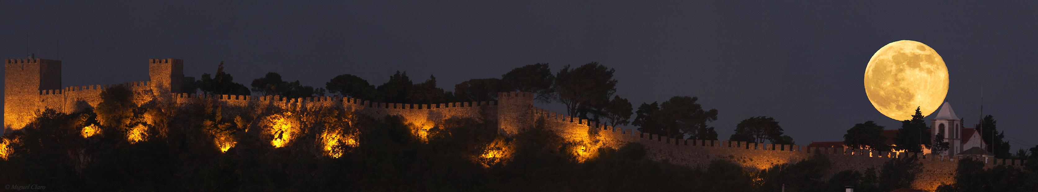
Below you will find a resume with all publications – printed and online – related to this particular photograph.
Please refer the i-frame above, generated automatically from the overview page Press.
Manivela Moonset

In the image we could see the moonset (almost like the sunset, with an orange tone) reflected in the Alqueva´s Lake water, where is located the old: “Fonte da Manivela” or in English the source crank. The image was captured in Mourão, a region of the great Alqueva Dark Sky Reserve. At the first sight, we could think that it wasn´t the moon, but maybe the Sun, so, how could we have sure ? First, because during the sunset we couldn´t see the stars and the sky so dark due to our atmosphere effect. And the most important, if you look carefully in full resolution, you will notice that the moon wasn´t completely full, in fact, due to an Earthshine effect, is also visible part of the moon´s left limb that is in the shadow (not directly illuminated by the sun), something that will not occur in the sun´s surface. Canon 50D – ISO1600, Exp. 10 segs. 24mm f/2.8 – 16/06/2013 00:50
Noudar Castle at Night

The green landscape That surrounds the Noudar castle, in Barrancos, Portugal, iluminated by the strong light of Full Moon, turning the night in day. Canon 60Da – ISO640, f/4; Exp. 3,20s ; 24mm. 26/04/2013 01h17 AM
Spring Milky Way

With the arrival of spring, the Milky Way begins to be visible in the skies of Portugal at dawn, in this image, captured in Monsaraz, in the Alqueva´s Dark Sky Reserve, you can watch it in plenty, thanks to this mosaic of 21 images that allows a large field of view, revealing this “arm” of our galaxy above the Convent of Orada (dated 1670).
Near the center and right of palm trees, the moon shines brightly, although not interfering with the giant arc of the Milky Way where it is possible to distinguish a lot of constellations like Ursa Minor, with the polaris star to the left of the image, until the swan (Cygnus), with its North America nebula (NGC7000) clearly visible, down to the right, we still find the constellation of Sagittarius and Scorpio, with the brilliant super giant star, Antares.
Canon 60Da – ISO1600 Lens 24mm f/2; Exp. 15 secs. Mosaic of 21 images, taken in 06/04/2013 at 5h32 AM.
Below is a special image with the identification

Convent of Orada and North America Nebula

Image of the Convent of Orada and North America Nebula NGC7000. Canon 60Da – ISO1600 24mm; f/2; 15 secs. 06/04/2013 at 04h36 AM
The Orada´s Convent

Night Sky image of the Convent of Orada, in Monsaraz, with it´s great cross. Canon 50D – ISO2500; 24mm; f/4; 30 secs. 13/01/2013 at 06h35 AM.
The Convent of Orada

Night Sky image of the Convent of Orada, in Monsaraz, with it´s great cross in the left side of the image. Canon 50D – ISO2500; 11mm; f/4.5; 30 secs. 13/01/2013 at 06h25 AM.
The planet Jupiter shining in Taurus

In the image, taken inside the Monsaraz Castle in the Alqueva Dark Sky Reserve, Portugal, facing to the constellation of Taurus, is visible the planet Jupiter at the right side of Aldebaran star. Above, is also visible the open cluster NGC1647, and close to it, the Vesta asteroid. Below in the image, above the Rocks from the wall castle, is clearly visible the M45, well known as Pleiades, the 7 sisters.
Canon 60Da – 35mm F/2.8 Exp.10s ISO3200 taken in 22/12/2012 4:13 AM
Sky Show above Monsaraz Castle

In this image taken inside the Monsaraz Castle, in the Alqueva Dark Sky Reserve, Portugal, we could see the Dark night with some interesting sky objects, like M46 and M47, M41, and above Sirius the Seagull nebula IC2177. Near the center top image, is visible another infrared emission from Rosette Nebula. Below, the Barnard´s Loop, Horse Head and Orion nebula M42. A little bit to the right above the star aldebaran, is visible the open cluster NGC1647 and above it another open cluster the NGC1746. Below is the brightest sky object capturing in this image, the planet Jupiter, shining near the pleaides M45, almost seting behing the wall castle. Above right, is located the California nebula, NGC1499.
Canon EOS60Da – F/2.8 Exp.13s ISO3200 35mm lens. Mosaic of 24 images. Image taken in 22/12/2012 at 4:31 AM.
The Blue Sirius

In this picture captured from the walls of Monsaraz Castle, we can see the entire Canis Major constellation, the star cluster M41, and the brightest star in the celestial sphere, with -1.46 mag. In this image Sirius is shown with unusual strong sparkles, not only produced by a photo star filter attached in the front lens of the camera, but also due to the strong dew which increase the diffusion and saturation effect, showing so, the true blue color of this star, for being at a hot temperature of 25,200K.
Canon 60Da – ISO3200 35mm f/2.8 Exp.13s in 22/12/2012 at 04h18 AM

Below you will find a resume with all publications – printed and online – related to this particular photograph.
Please refer the i-frame above, generated automatically from the overview page Press.
The Sky above Almendres Cromlech

The Cromlech of the Almendres megalithic complex (or Almendres Cromlech), located near Guadalupe, in the civil parish of Nossa Senhora de Guadalupe, municipality of Évora, is the largest existing group of structured menhirs in the Iberian Peninsula, and one of the largest in Europe. This archaeological site consists of several megalithic structures: cromlechs, and menhir stones
The construction of these structures date back to VI millennium B.C., and only rediscovered in 1966 by Henrique Leonor Pina. The construction phases, Almendres I date 6000 B.C and the Almendres II, date 5000 B.C Middle Neolithic. The relative chronology of the cromlech and menhirs is extremely complex and covers a period from the Neolithic to Chalcolithic, and it is believed that the monument had a religious/ceremonial purpose, or functioned as a primitive astronomical observatory.
About a dozen monoliths present some form of carved drawings,four of which exhibit only small circular holes. Monolith number 8, with a cut flat top at about breast level and showing several dimples, might have served for finer astronomical observation, specially spring equinox observation, by putting small stones on them. These observations might be made from stone 39, on the eastern focal point of the elliptic layout. (http://en.wikipedia.org/wiki/File:CromelequeAlmendres.png) Menhir 48, also exhibits a schematized anthropomorphic representation, surrouned by circles and associated with a crozier.

In the sky image, is visible the Orion Constellation above the stone circle, and the shadows of the stones projected in the land, due to the light of the moon which light up the landscape from the oposite site. Canon 50D – ISO 1250; f/4; Exp.30s 10mm em 20/12/2012 at 20:09

Almendres Cromlech startra
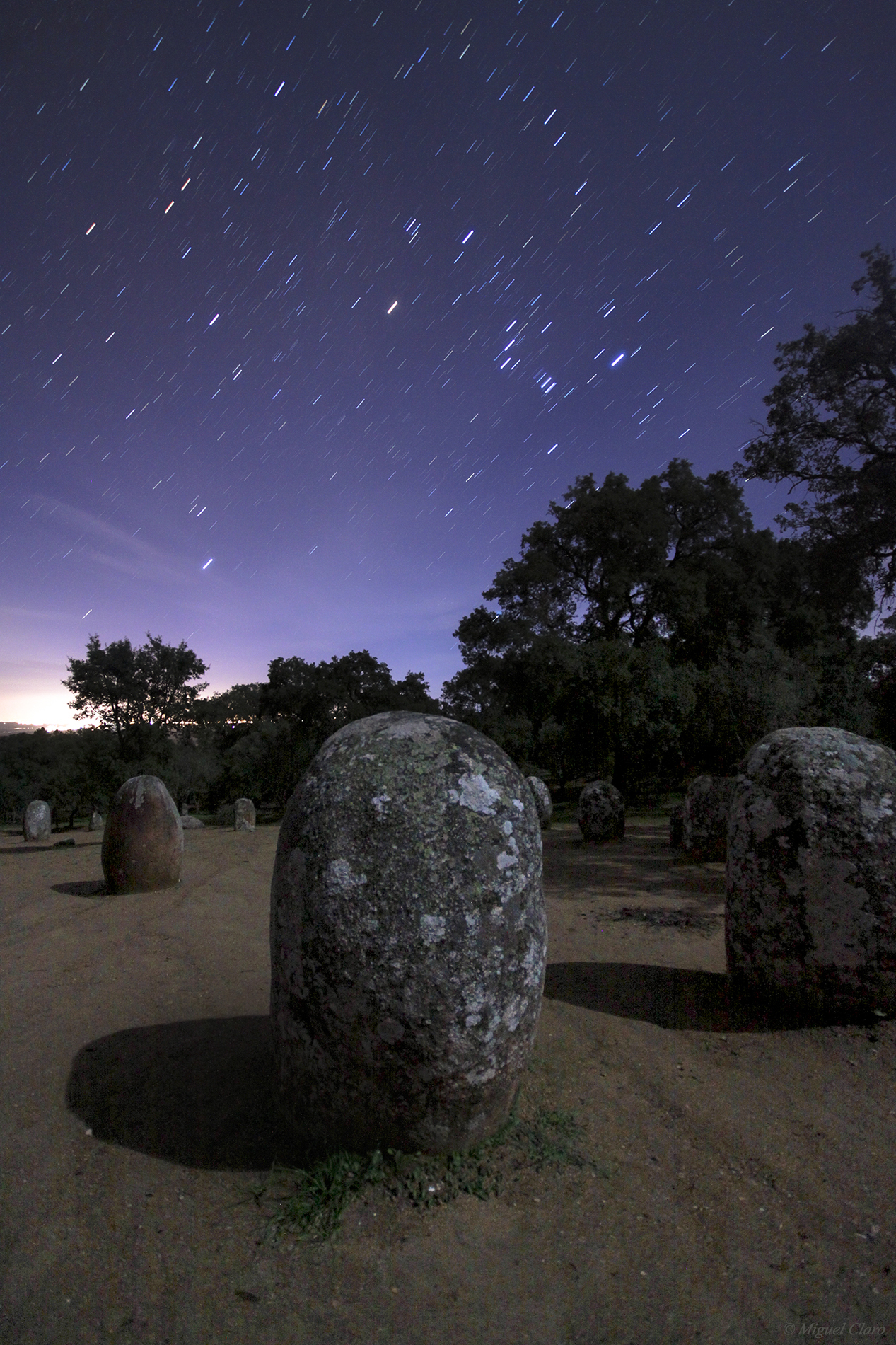
In the sky image, is visible the startrails of Orion Constellation above the stone circle, and the shadows of the stones projected in the land, due to the light of the moon, which light up the landscape from the oposite site.
Canon 50D – ISO 2000; f/4; Exp.25s 10mm em 20/12/2012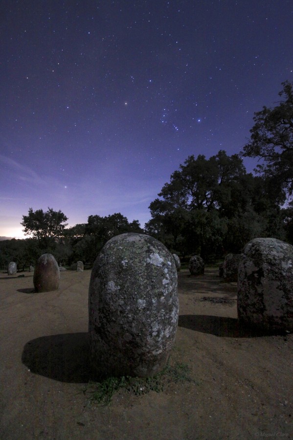
The Sword alignment – Venus, Moon,Jupiter and Pleiades

In the image we can see the sword of Dom Nuno Álvares Pereira, bypassing the moon. was a Portuguese general of great success who had a decisive role in the 1383-1385 Crisis that assured Portugal’s independence from Castile. He later became a mystic, was beatified by Pope Benedict XV in 1918 and was canonised by Pope Benedict XVI in 2009. For the same reason, the sword is turned down, as a sign of peace.
In the sky we could appreciate the alignment between Venus, Moon,Jupiter and Pleiades.
Canon 50D, ISO 640 with 35mm at f/5.6 Exp.4″. 15/07/2012 at 4:58 Am
Full Moon Cathedral – Évora

Full Moon behind the Cathedral of Évora situated in the historical centre of the city, which was included in the classification by UNESCO, as a World Heritage Site.
Canon 50D – ISO640 f/10 92mm Exp.5″ in 08-03-2012 at 21h11
Earthshine and the Monsaraz Village

Image from Monsaraz region, one of the locations covered by the great Dark Sky Reserve area and that had the best dark sky measures in the process of Starlight validation.
Covering 3000sq km in southern Portugal the Alqueva Dark Sky Reserve is the first area in the world to be internationally certified as a Starlight Tourism Destination by the Starlight Foundation. More info at: www.darkskyAlqueva.com.
Canon 50D – ISO 1250 f/5 168mm Exp. 6″ in 25-02-2012 at 21:32
Trails Above the Stones

Image from Monsaraz region, one of the locations covered by the great Dark Sky Reserve area and that had the best dark sky measures in the process of Starlight validation.
Covering 3000sq km in southern Portugal the Alqueva Dark Sky Reserve is the first area in the world to be internationally certified as a Starlight Tourism Destination by the Starlight Foundation. More info at: www.darkskyAlqueva.com.
Canon 50D – ISO 1250 f/4 10mm Exp. 30″ Sum of 165 images in a total integration of 82.5 minutes. in 25-02-2012 between 0:17 and 1:46
Starry Vortex

Image from Monsaraz region, one of the locations covered by the great Dark Sky Reserve area and that had the best dark sky measures in the process of Starlight validation.
Covering 3000sq km in southern Portugal the Alqueva Dark Sky Reserve is the first area in the world to be internationally certified as a Starlight Tourism Destination by the Starlight Foundation. More info at: www.darkskyAlqueva.com.
Canon 50D – ISO 1250 f/4 10mm Exp. 30″ Sum of 36 images in a total integration of 18 minutes. in 24-02-2012 between 23:37 and 23:56


