
Celtic Cross Against the Night Sky
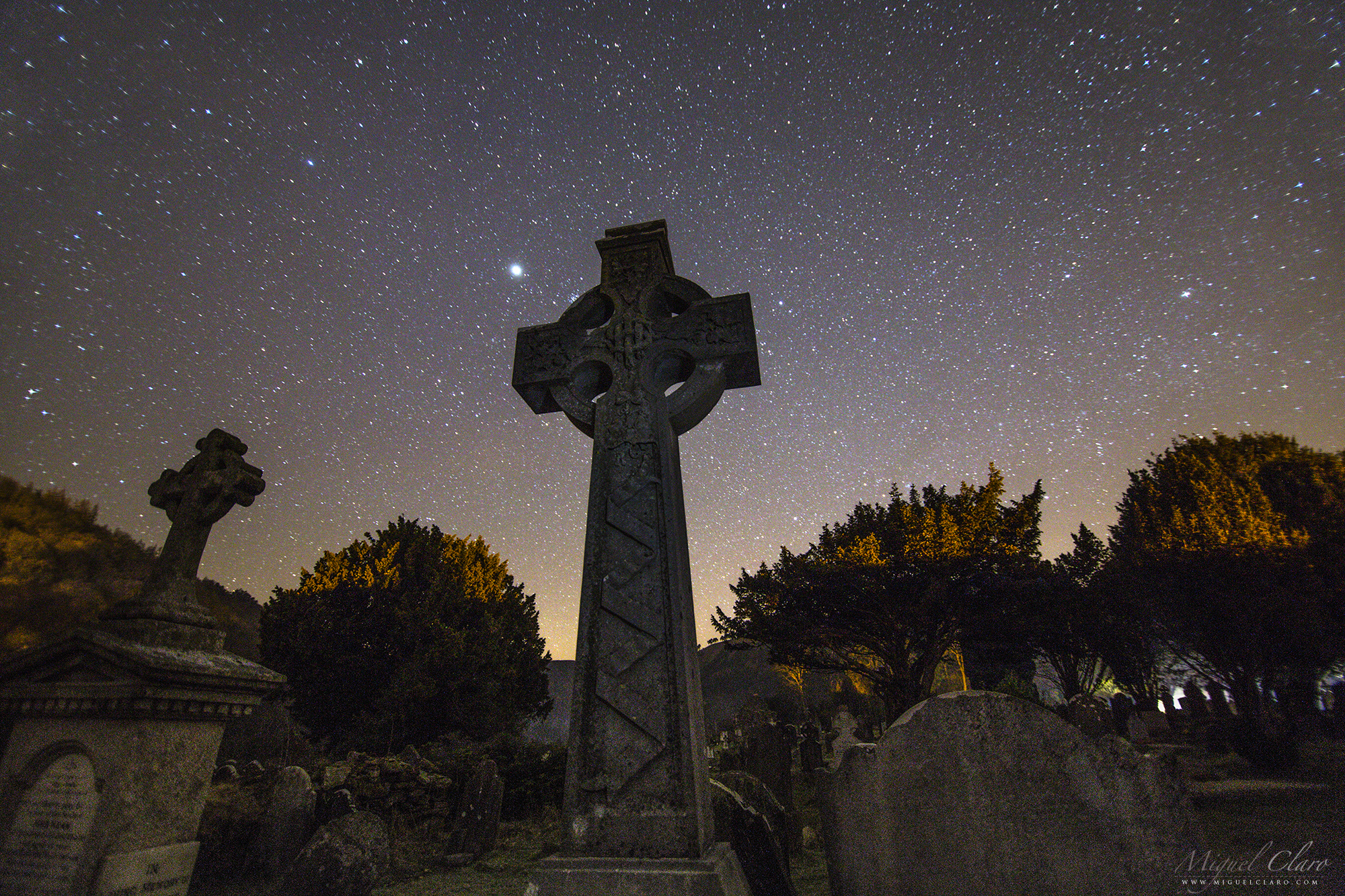
This Celtic Cross is a fine example of a plain cross remarkably carved from a single granite stone. The cross is the most ancient and powerful of symbols: an encounter of the vertical with the horizontal, the feminine & masculine, temporal & eternal. The circle of the Celtic cross, implying infinity, gives it a cosmic dimension. The arms of the cross are over a metre in length. The imperforate cross stands about 2.5m tall. It may have marked the boundary of the cemetery in which stands the priests’ house. This cross is a fine example of how St Patrick trying to help the once pagan people of Ireland acclimate to Christianity. This was done by combining the cross with the circle representing the sun, because the pagans worshipped the sun and moon. A local legend surrounding St. Kevin’s Cross says that anyone who can wrap their arms around the entire width of the cross body and close the circle by touching fingertips will have their wishes granted.
Glendalough (meaning “Valley of two lakes”) is a glacial valley in County Wicklow, Ireland, renowned for an Early Medieval monastic settlement founded in the 6th century by St Kevin. It combines extensive monastic ruins with a stunning natural setting in the Wicklow Mountains. The beauty and tranquility of the lakes and glacial-carved valley no doubt appealed to St Kevin, a hermit monk, who founded the monastic site near the Lower Lake in the 6th Century. Most of the buildings that survive today date from the 10th through 12th centuries. Despite attacks by Vikings over the years, Glendalough thrived as one of Irelands great ecclesiastical foundations and schools of learning until the Normans destroyed the monastery in 1214 and the dioceses of Glendalough and Dublin were united. The settlement was destroyed by English forces in 1398. A reconstruction program was started in 1878 and today the valley boasts a visitor centre, wooded trails, walkways and rock climbing. The monastic ruins include a round tower, seven churches, a gateway into the settlement with a Sanctuary Stone, two High Crosses, the priest’s house, a graveyard, Reeferts Church, St. Kevin’s Bed (Cave) and St. Kevin’s Cell (hermitage hut). More about.
PT: Esta cruz celta é um belo exemplo de uma cruz simples notavelmente esculpida de uma única pedra de granito. A cruz é o mais antiga e poderoso símbolo: um encontro do vertical com o horizontal, o feminino e masculino, temporal e eterno. O círculo da cruz celta, o que implica infinito, dá-lhe uma dimensão cósmica. Estas cruzes celtas podem ser encontradas no cemitério de Glendalough. Com o significado “Vale dos dois lagos”, é um vale glacial no condado de Wicklow, na Irlanda, conhecida por uma povoação monástica medieval precoce fundada no século 6 pelo St Kevin. Combina extensas ruínas monásticas com um cenário natural deslumbrante nas montanhas de Wicklow. A beleza e tranquilidade dos lagos e do vale glacial esculpido, sem dúvida, chamaram a atenção do monge eremita St Kevin . A maioria dos edifícios que sobreviveram até aos dias de hoje datam do século 12. Apesar dos ataques de Vikings ao longo dos anos, Glendalough prosperou como uma das grandes fundações eclesiásticas irlandesas e escolas de aprendizagem até que os normandos destruiram o mosteiro em 1214 e as dioceses de Glendalough e Dublin foram unidos. A liquidação foi destruída por forças inglesas em 1398. Um programa de reconstrução foi iniciado em 1878 e hoje o vale dispõe de um centro de visitantes, trilhas arborizadas, calçadas e escalada. As ruínas monásticas incluem uma torre redonda, sete igrejas, uma porta de entrada para a povoação com um Santuário de pedra, duas cruzes celtas altas, casa do padre e um cemitério.
The Giant Chestnut of Guilhafonso

EN: A blue sky filled with winter stars like Sirius or bright constellations like Orion, is illuminated by the Moonlight working as a perfect background to highlight the silhouette from the Giant Chestnut tree of Guilhafonso in Guarda, Portugal. This century-old tree is considered the largest of its kind in Europe. This is a specimen of 9.60 meters trunk circumference, 19 meters in height, average crown diameter of 25.5 meters and an estimated age of over 400 years. Residents ensure that they need at least nine people to embrace its trunk. In 2015 the giant chestnut won new liveliness after having been treated which allowed it to still giving chestnuts nowadays.
PT: Um céu azul repleto de estrelas de inverno como Sirius ou constelações brilhantes como Orion, é iluminada pelo luar funcionando como o pano de fundo perfeito para destacar a imponente silhueta do Castanheiro Gigante de Guilhafonso, na Guarda, Portugal. Esta árvore centenária é considerada a maior da sua espécie na Europa. Trata-se de um espécime de 9,60 metros de perímetro de tronco, 19 metros de altura, diâmetro médio da copa de 25,5 metros e uma idade estimada em mais de 400 anos. Os residentes garantem que são precisas pelo menos nove pessoas para abraçar o seu tronco. Em 2015, depois de ter sido submetido a um tratamento, o castanheiro gigante ganhou nova vivacidade o que permitiu continuar dar nozes até aos dias de hoje.
Venus Reflecting on Causeway Coast of Northern Ireland

Venus is the second-brightest natural object in the night sky after the Moon, reaching an apparent magnitude of −4.6, bright enough to cast shadows. Is the second planet from the Sun, orbiting it every 224.7 Earth days. It has the longest rotation period (243 days) of any planet in the Solar System and rotates in the opposite direction to most other planets. It has no natural satellite. It is named after the Roman goddess of love and beauty. Normally visible at Dawn or other times at Dusk, Venus has been a major fixture in human culture for as long as records have existed. It has been made sacred to gods of many cultures, and has been a prime inspiration for writers and poets as the “morning star” and “evening star”. In the image above, the brightness of this planet is reflecting in the ocean surface from Causeway Coast in Northern Ireland, due to a presence of tiny water droplets in thin clouds – which diffract the light of bright heavenly bodies working as a natural diffuse filter – we also can see a blueish color from its corona. The Giant’s Causeway is an area of about 40,000 interlocking basalt columns, the result of an ancient volcanic eruption. It is located in County Antrim on the northeast coast of Northern Ireland, about three miles (4.8 km) northeast of the town of Bushmills. It was declared a World Heritage Site by UNESCO in 1986, and a national nature reserve in 1987 by the Department of the Environment for Northern Ireland.
Enjoying the Moon above the City of London

A skygazer is enjoying the busy night of London city, from a lovely balcony view, with the crescent moon visible at the left side of “The Shard” tower. Also referred as the Shard of Glass and formerly London Bridge Tower, is a 95-storey skyscraper in Southwark, London, that forms part of the London Bridge Quarter development. Standing 309.6 metres (1,016 ft) high, the Shard is the tallest building in the United Kingdom, the 105th tallest building in the world, and the fourth tallest building in Europe.
The Shard Tower and Crescent Moon in London

This London twilight cityscape view, shows de Crescent Moon at the left side of “The Shard” tower. Also referred as the Shard of Glass and formerly London Bridge Tower, is a 95-storey skyscraper in Southwark, London, that forms part of the London Bridge Quarter development. Standing 309.6 metres (1,016 ft) high, the Shard is the tallest building in the United Kingdom, the 105th tallest building in the world, and the fourth tallest building in Europe.
PT: Esta imagem Cityscape da cidade de Londres captada durante o crepúsculo náutico, mostra a Lua Crescente à esquerda da torre londrina “The Shard”. Também conhecido como “Shard of Glass” e anteriormente London Bridge Tower, é um arranha-céu de 95 andares em Southwark, Londres, que faz parte do Quarter London Bridge. Atingindo 309,6 metros (1.016 pés) de altura, o Shard é o edifício mais alto do Reino Unido, o edifício 105º entre os mais altos do mundo, e o quarto edifício mais alto da Europa.
Beyond the Limits of Earth – Astrophotography from an Airplane

When I was back to Lisbon from a large trip between Chile, Argentina and Uruguay with a stopover in São Paulo, Brazil, I had a rare opportunity somewhere in the middle of the Atlantic Ocean and under the moonlight to take some images from the window of an airplane, during the sleeping hours, when the lights of the plane were shut off. I asked my colleague Apolónia Rodrigues to cover my head with a black jacket around the window to avoid any reflections from inside. The shutter speed had to be very fast for a night sky photography because it was very difficult to have a pinpoint stars without shaking with the movements of the plane. After a few attempts and efforts, I could capture some nice views with the stars and the night sky above Earth taken at a high altitude, probably between 10,000 to 12,000 meters at a cruise speed of ~900km/h, some of them with lightning below.

Due to the presence of moonlight we can distinguish very well the limb and transition between the blue color from our atmosphere and the black from outer space. Blue light is scattered more than other wavelengths by the gases in the atmosphere, giving Earth a blue halo. The atmosphere of Earth is the layer of gases, commonly known as air, that surrounds the planet Earth and is retained by Earth’s gravity. The atmosphere protects life on Earth by absorbing ultraviolet solar radiation, warming the surface through heat retention (greenhouse effect), and reducing temperature extremes between day and night (the diurnal temperature variation). The atmosphere has a mass of about 5.15×10¹⁸ kg, three quarters of which is within about 11 km (6.8 mi; 36,000 ft) of the surface. The atmosphere becomes thinner and thinner with increasing altitude, with no definite boundary between the atmosphere and outer space. The Kármán line, at 100 km (62 mi), or 1.57% of Earth’s radius, is often used as the border between the atmosphere and outer space.
PT: De regresso a Lisboa a partir de uma grande viagem entre o Chile, Argentina e Uruguai com escala em São Paulo, Brasil, eu tive uma oportunidade rara enquanto estava algures a sobrevoar o Oceano Atlântico, de captar imagens ao luar a partir da janela de um avião comercial, durante as horas de sono e enquanto as luzes do avião foram desligados. Pedi à minha colega de equipa Apolónia Rodrigues para me cobrir a cabeça e ao redor da janela com um casaco preto, no sentido de evitar quaisquer reflexos a partir do interior do avião. A velocidade do obturador tinha que ser muito rápida para uma fotografia de céu noturna, porque era muito difícil ter estrelas pontuais com a agitação do avião. Depois de algumas tentativas e esforços, tive a felicidade de captar algumas imagens com as estrelas pontuais onde se distinguem as estrelas que compõem o Cão Maior e Orion e onde é possível ver também o contorno da atmosfera acima da Terra. As imagens foram tiradas a uma alta altitude, provavelmente entre 10.000 a 12.000 metros e a uma velocidade de cruzeiro de ~ 900 km/h, alguns deles com relâmpagos abaixo .

The troposphere is the lowest layer of Earth’s atmosphere. It extends from Earth’s surface to an average height of about 12 km, although this altitude actually varies from about 9 km (30,000 ft) at the poles to 17 km (56,000 ft) at the equator, with some variation due to weather. Most conventional aviation activity takes place in the troposphere, and it is the only layer that can be accessed by propeller-driven aircraft.
In one of the pictures I made an annotation with the main constellations visible. Orion and Sirius are very well spotted. Each one is a single shot: Canon 6D, Exp: 1/3s; ISO8000 24mm f/2.8
Prime Meridian Laser in Greenwich
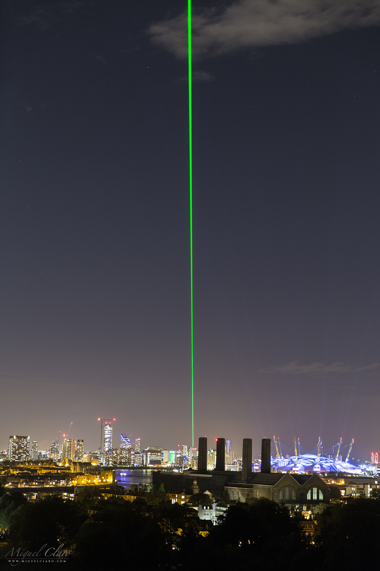
The Greenwich Meridian separates east from west in the same way that the Equator separates north from south. Inextricably linked with Greenwich Mean Time, it also sits at the centre of our system of time zones. Its path is determined by the location of an historic telescope, the Airy Transit Circle (51°28′40.1″N 0°0′5.3″W), which is housed at the Royal Observatory of Greenwich, in London. The Prime Meridian was established by Sir George Airy in 1851.
A prime meridian is a meridian (a line of longitude) in a geographical coordinate system at which longitude is defined to be 0°. Together, a prime meridian and its antimeridian (the 180th meridian in a 360°-system) form a great circle. This great circle divides the sphere, e.g., the Earth, into two hemispheres. If one uses directions of East and West from a defined prime meridian, then they can be called Eastern Hemisphere and Western Hemisphere.
PT: O meridiano de Greenwich separa “Este” de “Oeste” da mesma forma que o Equador separa o Norte do Sul. Intimamente ligado com Greenwich Mean Time, também está no centro do nosso sistema de fusos horários. O seu caminho é determinado pela localização de um telescópio histórico, o “Airy Transit Circle” (51°28′40.1″N 0°0′5.3″W), que está localizado no Observatório Real de Greenwich, em Londres. O Meridiano de Greenwich foi criada por Sir George Airy em 1851.
The Prime Meridian in Greenwich Observatory, was long marked by a brass strip in the courtyard, now replaced by stainless steel, and, since 16 December 1999, has been marked by a powerful green laser shining north across the London night sky. The Meridian laser marks the route of the Greenwich Meridian by night in a northerly direction from the Royal Observatory. Under good viewing conditions, it is visible at a distance of over 36 miles with the naked eye and over 60 miles with binoculars.
Summer Triangle above Vatican City State

The Summer Triangle is an astronomical asterism involving an imaginary triangle drawn on the northern hemisphere’s celestial sphere, with its defining vertices at Altair, Deneb, and Vega, the brightest stars in the three constellations of Aquila, Cygnus, and Lyra, respectively. Only this 3 stars are bright enough to be visible above the light polluted sky from the City State of Vaticano, in Rome, Italy.
Near midnight, the Summer Triangle lies virtually overhead at mid-northern latitudes during the summer months, but can also be seen during spring in the early morning to the East. In the autumn the summer triangle is visible in the evening to the West well until November. From the southern hemisphere it appears upside down and low in the sky during the winter months.
The Church has had a long-standing interest in astronomy, due to the astronomical basis of the calendar by which holy days and Easter are determined. For instance, the Gregorian Calendar, promulgated in 1582 by Pope Gregory XIII, was developed by Aloysius Lilius and later modified by Christoph Clavius at the Collegio Romano from astronomical data. The Gregorian Tower was completed in 1580 for his purpose, designed by Bolognese architect Ottaviano Matte.
The Vatican Observatory (Latin: Specola Vaticana) is an astronomical research and educational institution supported by the Holy See. Originally based in the Roman College of Rome, the Observatory is now headquartered in Castel Gandolfo, Italy and operates a telescope at the Mount Graham International Observatory in the United States. In the 18th century, the Papacy actively supported astronomy, establishing the Observatory of the Roman College in 1774. In 1789–1787, the Specola Vaticana in the Tower of the Winds within the Vatican was established under the direction of Msgr. Filippo Luigi Gilii (1756–1821). When Msgr. Gilii died, the Specola was closed down because it was inconvenient for students in the city because the dome of St. Peter’s obstructed its view. Its instruments were transferred to the College Observatory. A third facility, the Observatory of the Capitol, was operated from 1827 to 1870. In 1891, however, Pope Leo XIII issued a Motu Proprio re-founding the Specola Vaticana (Vatican Observatory) and a new observatory was built on the walls at the edge of the Vatican.The new Vatican Observatory remained there for the next forty years.
By the 1930s, the smoke and sky-glow of the city had made it impossible to conduct useful observations in Rome. Pope Pius XI relocated the Observatory to Castel Gandolfo, which is 25 kilometres (16 mi) southeast of Rome. By 1961, the same problems with light pollution made observing difficult at Castel Gandolfo. The Observatory then established the Vatican Observatory Research Group, with offices at the Steward Observatory of the University of Arizona in Tucson, Arizona.
PT: O Triângulo de Verão é um asterismo astronómico envolvendo um triângulo imaginário “desenhado na esfera celeste” do hemisfério norte, com os seus vértices a definirem Altair, Deneb e Vega, as estrelas mais brilhantes nas três constelações de Aquila, Cygnus e Lyra, respectivamente. Só estas 3 estrelas conseguem ser suficientemente brilhantes para serem visíveis a partir de um céu poluído como o que se ergue acima do Estado da Cidade do Vaticano, em Roma, Itália.

Officially called Vatican City State or the State of Vatican City is a walled enclave within the city of Rome. With an area of approximately 44 hectares (110 acres), and a population of 842, it is the smallest sovereign state in the world by both area and population. It is an ecclesiastical or sacerdotal-monarchical state (a type of theocracy) ruled by the Bishop of Rome – the Pope. The highest state functionaries are all Catholic clergy of various national origins. Since the return of the Popes from Avignon in 1377, they have generally resided at the Apostolic Palace within what is now Vatican City. Vatican City is distinct from the Holy See (Latin: Sancta Sedes), which dates back to early Christianity and is the main episcopal see of 1.2 billion Latin and Eastern Catholic adherents around the globe. The independent city-state, on the other hand, came into existence in 1929 by the Lateran Treaty between the Holy See and Italy, which spoke of it as a new creation, not as a vestige of the much larger Papal States (756–1870), which had previously encompassed much of central Italy. According to the terms of the treaty, the Holy See has “full ownership, exclusive dominion, and sovereign authority and jurisdiction” over the city-state.
Penumbral Lunar Eclipse in the Harvest Moon above Sesimbra Castle

On september 16h the disc of the moon has reached the 100% illumination exactly at the same time he was rising in the portuguese sky. This september Full Moon is known, according to folklore, as the Harvest Moon, “a bright orb that shines down on the ripening fields of the northern hemisphere, allowing farmers to harvest their crops late into the night”. Besides his normal brightness when it is Full, this particular Moon was a bit darker then normal, due to a penumbral lunar eclipse, that happens when the Moon passes through the pale outskirts of Earth’s shadow. It is much less dramatic than a total lunar eclipse. The final image is a sequence shot captured during 25 minutes, at the moonrise, with a 200mm lens at about 700 meters away from the Sesimbra Castle, in Portugal.
PT: Eclipse penumbral da Lua captada no dia 16 de Setembro. Nesta sequência de disparos combinada, é possível o nascer da Lua acima do Castelo de Sesimbra. Como o eclipse é penumbral, apenas a região superior da lua é ligeiramente escurecida pelo cone de sombra da terra.
Colorful Night Sky – A Stellar Spectrum

When we first look at the night sky, we can not distinguish the color of each star with our own eyes, although, if we record in a long exposure sequence the path of each star, due to the motion of rotating Earth and consequently the rotation of celestial sphere, a starry trailed sky can reveal much of our colorful Universe. In the image above, captured in Noudar Park, Alqueva Dark Sky® Reserve, Portugal, we can see a lot of different color paths, like: blue, yellow, white or orange. Each color is directly related to the type and temperature of each star. Some of them are hottest, like Alfirk, in Cepheus constellation, and some are coolest like Eltanin, in Draco.
In astronomy, stellar classification is the classification of stars based on their spectral characteristics. Electromagnetic radiation from the star is analyzed by splitting it with a prism or diffraction grating into a spectrum exhibiting the rainbow of colors interspersed with absorption lines. Each line indicates an ion of a certain chemical element, with the line strength indicating the abundance of that ion. The relative abundance of the different ions varies with the temperature of the photosphere. The spectral class of a star is a short code summarizing the ionization state, giving an objective measure of the photosphere’s temperature and density.
Most stars are currently classified under the Morgan–Keenan (MK) system using the letters O, B, A, F, G, K, and M, a sequence from the hottest (O type – blue stars) to the coolest (M type – red stars). Each letter class is then subdivided using a numeric digit with 0 being hottest and 9 being coolest (e.g. A8, A9, F0, F1 form a sequence from hotter to cooler). The sequence has been expanded with classes for other stars and star-like objects that do not fit in the classical system, such as class D for white dwarfs and class C for carbon stars.
In the MK system, a luminosity class is added to the spectral class using Roman numerals. This is based on the width of certain absorption lines in the star’s spectrum, which vary with the density of the atmosphere and so distinguish giant stars from dwarfs. Luminosity class 0 or Ia+ stars for hypergiants, class I stars for supergiants, class II for bright giants, class III for regular giants, class IV for sub-giants, class V for main-sequence stars, class sd for sub-dwarfs, and class D for white dwarfs. The full spectral class for the Sun is then G2V, indicating a main-sequence star with a temperature around 5,800 K. Source and more info: click here.
PT: Quando de noite olhamos para o céu não conseguimos percepcionar com os nossos próprios olhos a cor de cada estrela, no entanto, se registarmos numa sequência de longa exposição o rasto de cada estrela, devido ao movimento de rotação da Terra e à consequente rotação da esfera celeste, uma imagem startrail poderá revelar um Universo colorido e rico em informação. Na imagem acima captada no Parque de Natureza de Noudar, Reserva Dark Sky® Alqueva, em Barrancos, podemos ver uma grande diversidade de cores desde o azul, ao amarelo, branco ou laranja. Cada cor está directamente relacionada com o tipo e temperatura de cada estrela. Algumas delas são mais quentes, como Alfirk, na constelação do Cefeu, e outras são mais frias como Eltanin, no Dragão.

Bridge of Light – Connecting worlds, realities and dimensions

EN: A bridge could be a connection of two worlds, realities or dimensions, or simply two sides of lake as we can see on the image, but in a figurative sense, could also be a word that simbolizes a “perfect connection” between pristine and modern, the night sky and the landscape of our beautiful planet in suspension among the arm of gas and dust from our galaxy, the Milky Way. Reflected in the calm water of the largest manmade lake in Europe (250Km²) are the light of a slowly lonely car that took several seconds to cross the entire bridge. But also the light of the stars, which took hundred or millions of years at a speed of light to reach this particular point, ready to be recorded in this singular picture taken from one of the rare Dark Sky places on Earth, in Mourão, Alqueva Dark Sky Reserve.
PT: Uma ponte pode ser a conexão de dois mundos, realidades ou dimensões, ou simplesmente a ligação a duas margens de um lago. Em sentido figurado, também pode ser uma palavra que simboliza uma “conexão perfeita” entre o Prístino e o Moderno, o céu noturno e a paisagem do nosso belo planeta em suspensão entre o braço de gás e poeira cósmica da nossa galáxia, a Via Láctea. Refletida na água calma do maior lago artificial da Europa (250Km²), está não só a luz de um carro lento e solitário que levou vários segundos para completar a travessia desta ponte e gravar o seu trajecto no espelho de água do Alqueva, como também o brilho das estrelas que levou dezenas, centenas e milhares de anos a percorrer numa viajem à velocidade da luz, a distância que nos separa no longínquo vácuo Interestelar. Aqui ficaram registadas as impressões de luz de uma viagem no tempo e no espaço, na história da própria Terra, do próprio Homem, um ser inteligente mas ainda recente na cronologia da vida deste Universo, que nesta imagem singular nos é revelado em perfeita harmonia e sintonia com a natureza que nos rodeia, num dos raros lugares da Terra onde o céu da antiguidade, ainda pode ser apreciado, partilhado e lembrado. Mourão, Dark Sky® Alqueva.
Perigee Earthshine and Planet Mercury above Lisbon City

Featured as NASA´s Astronomy Picture of the Day (APOD).
We use the term of “Super Moon” when the moon is at the Perigee, closer to Earth, which is not so rare, occurring 13 times this year 2016. But to our naked eyes we only notice that moon is indeed, larger in the sky (15% bigger and 30% brighter) when the moon is normally full, capturing our attention during this period. On April 7, the New Moon was at the Perigee, so in the day after, on April 8, with only 3% of the disc illuminated by the sunlight, it would be considered a Super Crescent Moon, a perfect moment to show up the Earthshine phenomenon described and drawn for the first time by Leonardo DaVinci 500 years ago.

In the lovely view captured 8.5km straight from Lisbon city, from Barreiro region, with a telephoto lens, we can see in nautical twilight a beautiful alignment between the Super Crescent Moon and the planet Mercury – the bright “star” located at the same line – only separated by 6º, an easy target to find thanks to the help of our natural satellite, standing in the background above the monument Christ the King and the 25 April bridge. Above on the image, are seen reflections of light pollution in the water of Tagus River. In that night, to wind was so strong that my local good friend and photographer Nuno Lopes, was holding the cargo cover all the time, trying to protect me and my equipment from the strong winds, while I was photographing the telephoto scene showed below. Both of my cameras and William Optics telescope, were assembled in the new Advanced Vixen Polarie portable mount.

Rainbow Bands of Airglow in Gravity Waves above Pico Island Were seen from NOAA/NASA Satellite in Space

Featured as NASA´s Astronomy Picture of the Day (APOD).
PT | EN During a climb to the highest mountain of Portugal (2351m) – Pico mountain, located in Pico island, Azores – with a very hard weather conditions due to a strong winds and rain during almost the entire photo expedition with my team colleagues, I stopped at about 1200 meters to appreciate the views and photograph the lights coming from the island of Faial in the middle of the Atlantic Ocean, in a rare occasion with only a few clouds and part of the “winter” Milky Way visible as a background of a temporarily clear sky. Above the low clouds, I have captured strange “rainbow bands” of airglow and between them, the Andromeda Galaxy M31 on the top left of the picture. The air glows all of the time, but it is usually hard to see. A disturbance however – like an approaching storm – may cause noticeable rippling in the Earth’s atmosphere. The bands are actually huge parallel structures in the thermosphere 90 km upwards. Perspective makes them appear to converge. These atmospheric Gravity Waves* (not confound with gravitational waves related to Einstein) propagating upwards from disturbances lower down in the atmosphere, are likely the source of the bands. The wave amplitude increases with height (reducing density) and wavelengths can be thousands of kilometers.
Dr. Martin Setvák from Czech Hydrometeorological Institute Satellite Department, Praha, Czech Republic, has processed the Suomi-NPP VIIRS data to check if these gravity waves in airglow can be found in NOAA/NASA Soumi-NPP satellite Day/Night Band (DNB) image. The “day-night band,” of the Visible Infrared Imaging Radiometer Suite (VIIRS) on the Suomi NPP satellite has indeed captured these glowing ripples in the night sky. The day-night band detects lights over a range of wavelengths from green to near-infrared and uses highly sensitive electronics to observe low light signals. The structures of the bands can be seen below, above the Pico and Faial islands in Azores, Portugal.

Airglow is a layer of nighttime light emissions caused by chemical reactions, light of electronically and/or vibration-rotationally excited atoms and molecules high in Earth’s atmosphere, by solar ultra-violet radiation. A variety of reactions involving oxygen, sodium, ozone, and nitrogen result in the production of a very faint amount of light. In fact, it’s approximately one billion times fainter than sunlight. Technically speaking, airglow occurs at all times. During the day it is called “dayglow,” at twilight “twilightglow,” and at night “nightglow”. There are slightly different processes taking place in each case, but in the image above the source of light is nightglow or airglow.
In the first colorful image captured above Pico, we can see a rare event where is distinguished almost each possible airglow color that is appearing on a single band (Gravity Wave) showed like a rainbow. Below is the Airglow Spectrum designed and explained by the expert Dr. Les Cowley from Atmospheric Optics. Green light from excited oxygen atoms dominates the glow. The atoms are 90-100 km (56-62 mile) high in the thermosphere. The weaker red light is from oxygen atoms further up. Sodium atoms, hydroxyl radicals (OH) and molecular oxygen add to the light.

Dr. Steve Smith, Senior Research Scientist at Center for Space Physics of Boston University, is a specialist in airglow and has explained the rare phenomenon captured on these images: “The photo is very other-worldly but it is indeed a photo of two, maybe three, airglow layers with gravity waves propagating through them in the upper mesosphere. The green is most likely due to atomic oxygen near 96 km. The red is probably due to hydroxyl (OH) near 87 km. Possibly sodium from near 90 k m also but the orange may also just be the response of the system to the combination of the red and green airglow. The awesome rainbow appearance of the patterns is easily explained. A GW wave propagates upwards at an angle and because airglow layers reside at slightly different altitudes, the waves reach each layer at a slightly different times. The vertical scale size of the gravity waves is also much larger than the height differences between the layers: OH = 87 km | Na = 90 km | O2 = 94 km | OI = 96 km.
I exploit the fact of the altitude separation of the four brightest airglow layers in my work to determine the scale sizes and other things associated with the GWs. Sometimes atomic oxygen can also produce red emission. This occurs due times of auroral activity particularly at high latitudes but occasionally in the mid-latitudes during strong aurora. This red-line OI emission, as it is called, originates from 250 km (much higher) in the thermosphere and would not match wave patterns seen in the green-line OI emission.
Solar activity has little effect on gravity wave activity in the mesosphere, at least at the latitude of the Azores. There may be effects at high latitudes though. Also solar activity seen on the sun’s disc doesn’t necessarily impact the Earth. Flares and other solar phenomena that are rich in x-rays and UV radiation can cause immediate effects in the earth’s upper atmosphere. Also, even though a CME my be observed occurring on the sun, it may not affect the Earth because they usually miss us because of the sun’s rotation. The Kp index – a measure of the solar activity prior to the time of this photo was at 2-3, which means a relatively quiet time. At the location of the Azores, one would need a Kp index of 6-7 to see auroral emission.”
Dr. Steven D. Miller, Senior Research Scientist – Deputy Director Cooperative Institute for Research in the Atmosphere – Colorado State University, have commented the fact that the photos were taken at high altitude and this would probably be the reason why the greens are seen so well, since oxygen in the lower atmosphere will absorb much of that downwelling emission.
Dr. Les Cowley, explain in Atmospheric Optics page that red/orange could be yet more oxygen airglow, this time from atoms 150-300km high where the atmosphere is so sparse and collisions so infrequent that the atoms have time to radiate ‘forbidden’ light (1D ->3P) before losing their electronic excitation in impacts with other atoms and molecules. Deep red banded airglow is likely emission from vibrationally excited OH radicals in a layer ~86km high. Blue airglow is much much fainter and not very obvious on the image. Excited molecular oxygen at ~95 km high can produce it. The excitation is indirect. Possible routes are via daylight dissociation of N2 and NO or twilight recombination of NO+ whose reaction products generate excited O2. The oxygen then decays by emitting blue multi-wavelength banded radiation (Herzberg bands) if it is not first collisionally de-excited.

After receiving the first results of the Suomi-NPP VIIRS satellite, I decided to start processing another 12 images taken in the same place and time, to create a wide-angle – panoramic view – of more than 200º where it is clearly visible the airglow activity combined with strong ripples from gravity waves occurring in a huge part of the sky from West to Northeast (from left to right on the panoramic image above). At the same time, Dr. Martin Stevák, starts the final stage of processing the images taken by Suomi-NPP VIIRS satellite but in different bands and the result is shown below. These are in Transverse Mercator projection, centered at 38.5N 28W, remapped to 1km pixel size (for Azores).
 DNB image
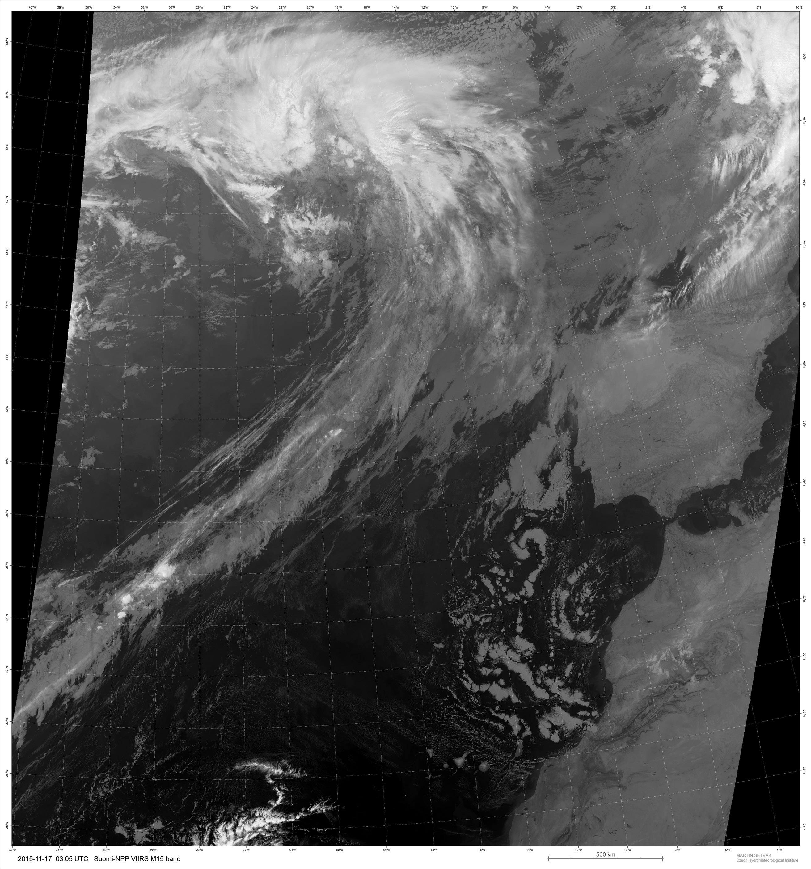 M15 IR band image
 Night-Microphysical RGB image
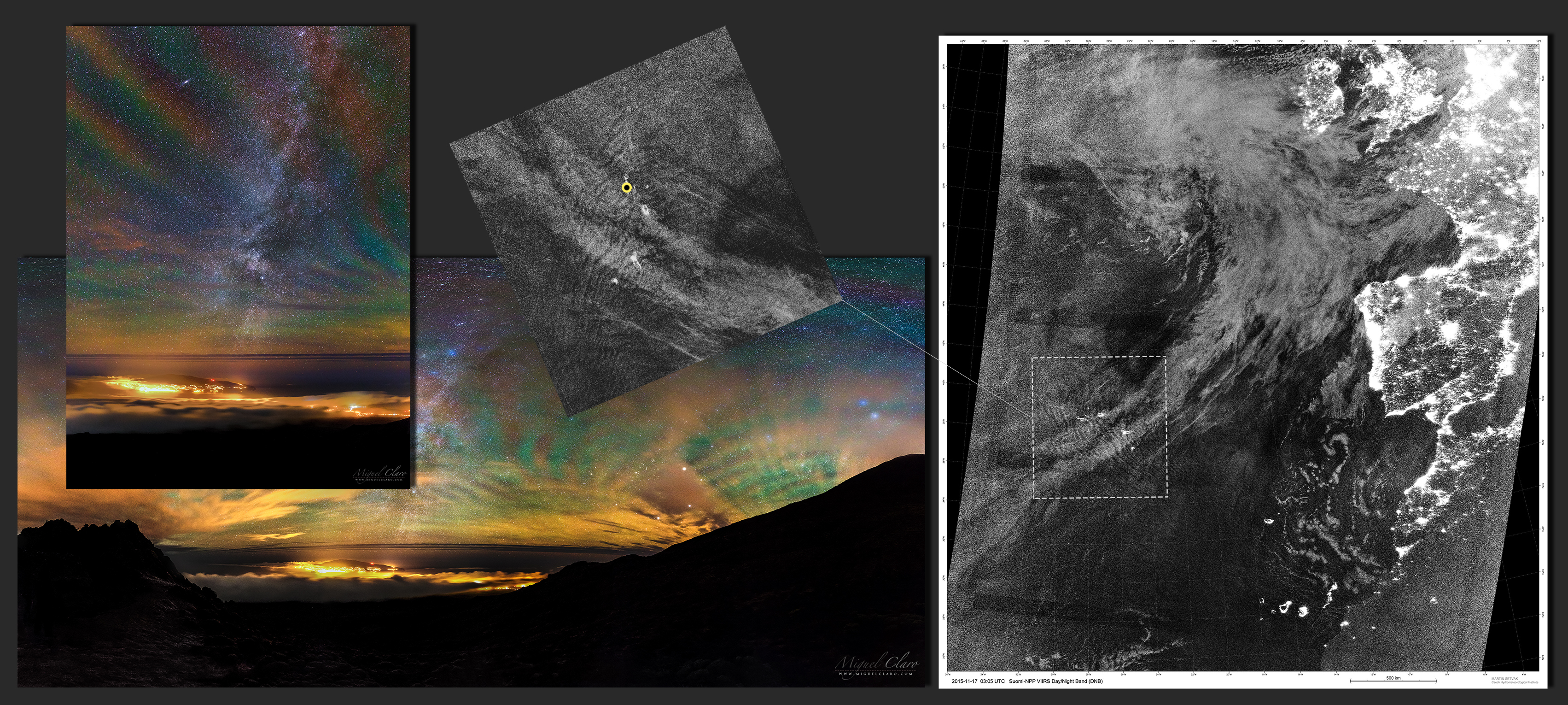
More information about Suomi-NPP satellite and its bands can be found on the following links: http://www.nasa.gov/mission_pages/NPP/main/index.html | http://npp.gsfc.nasa.gov/suomi.html | http://rammb.cira.colostate.edu/projects/npp/ | http://www.pnas.org/content/109/39/15706.full.pdf | http://www.mdpi.com/2072-4292/5/12/6717
Below, on (A) we can see the DNB image, that can show the Gravity Waves appearing high in the atmosphere, but on (B) Night-Microphysical RGB image can show a different waves from low atmosphere, they are very likely part of the same spectrum of waves launched by the small island of Flores. The (C) is an output from EUMETRAIN’s ePort (http://www.eumetrain.org/eport.html), for 2015-11-17 00 UTC, based on Meteosat WV6.2 band and showing the geopotential (“height”) of the 300 hPa pressure level (in cyan) and isotachs (yellow) at the same level (both from the ECMWF model). The red arrow indicates the jet-stream above the Azores. The (D) is the WV band 27 from Terra MODIS satellite taken at 00:20 UTC. The images are in the same projection and pixel size as the Soumi-NPP images (A & B). The (E) is a Meteosat-10 satellite in the Airmass-RGB product, documenting the dynamics of the atmosphere in the area, and namely showing the jet stream above Azores, taken at 03:00 UTC, the arrow points to the jet-stream band, and the polygon indicates roughly the area covered by NPP images. To watch a 24h loop from Meteosat-10 satellite, click here.

Below is a illustration from a combination of Google Earth Maps from Azores region and Stellarium planetarium software, that can show through the yellow dot, where I was located in the island and which direction my camera was pointing to the sky – as we can see in the illustration at right.

Gravity waves (disturbances to the density structure of the atmosphere whose restoring forces are gravity and buoyancy) comprise the principal form of energy exchange between the lower and upper atmosphere. Wave breaking drives the mean upper atmospheric circulation, determining boundary conditions to stratospheric processes, which in turn influence tropospheric weather and climate patterns on various spatial and temporal scales. Despite their recognized importance, very little is known about upper-level gravity wave characteristics. The knowledge gap is mainly due to lack of global, high-resolution observations from currently available satellite observing systems. The capability of the Day/Night Band (DNB) on the NOAA/NASA Suomi National Polar-orbiting Partnership environmental satellite to resolve gravity structures near the mesopause via nightglow emissions at unprecedented subkilometric detail, are impressive. On moonless nights, the Day/Night Band observations provide all-weather viewing of waves as they modulate the nightglow layer located near the mesopause (∼90 km above mean sea level). These waves are launched by a variety of physical mechanisms, ranging from orography to convection, intensifying fronts, and even seismic and volcanic events. Cross-referencing the Day/Night Band imagery with conventional thermal infrared imagery also available helps to discern nightglow structures and in some cases to attribute their sources. The capability stands to advance our basic understanding of a critical yet poorly constrained driver of the atmospheric circulation. More about this study and scientific paper which includes the picture of my TWAN colleague Jeff Dai , led by Dr. Steven D. Miller, Dr. Steve Smith and others…
Below in gray scale are DNB images captured by Suomi-NPP VIIRS satellite above Pico island, Azores, as a result of a pre-processing enhanced by a High-Pass filter. Taken on 17th November of 2015 at 02h05AM (03h05 GMT. Local time for the Azores is GMT-1,) approximately at same time I took the pictures from Earth between 1h43 and 2h00AM, pointing to the same direction of the sky. Those waves seen at ~2AM local were right overhead at that time. The waves can change rapidly over the course of an hour, so must have been a very expansive wave train, which seems to be consistent with a large-scale forcing like a frontal system. The result shows the ripples of atmospheric Gravity Waves (left and right image).

Suomi NPP is in orbit around Earth at 834 kilometers (about 518 miles), well above the nightglow layer. The day-night band imagery contains signals from the upward emission of the nightglow layer and the reflection of the nightglow emissions from clouds and Earth’s surface. While nightglow is a well-known phenomenon, it is not typically considered by meteorological sensors. In fact, scientists were surprised at Suomi NPP’s ability to detect it. During the satellite’s check-out procedures, scientists thought this light source was a problem with the sensor until they realized that they were seeing the faintest light in the darkness of night. Learn more about the VIIRS day-night band and nighttime imaging of Earth in this story: Out of the Blue and Into the Black.
In conclusion, Dr. Steven D. Miller, has shared his thoughts related to this picture and beyond…by saying: “is that it would be very nice to have such observations on a geostationary satellite platform so as to be able to observe the wave motion and from that information infer important properties of the energy transfer. The community has a growing interest for such observations now that we are seeing them in “snapshot mode” from the Day/Night Band. The hope is that the publicity gained by such nice photos as yours will help to raise awareness on our need to better characterize the full atmospheric circulation if we hope to represent climate processes accurately in the models we appeal to for insight on climate change.”
The resulted image was also published in a Poster from Dr. Martin Setvák and Dr. Steven D. Miller entitled:
The TWAN ( The World at Night ) have now one of the best collection of hight quality images in the world with many different views of Airglow and Gravity Waves phenomenon captured by TWAN photographers spread around the globe, that could be a great scientific tool to help scientists understanding better this atmospheric phenomenon, as seen from different places on Earth and comparing them to the satellite images from Space.
Professional astronomer and TWAN photographer Yuri Beletsky, in an interesting answer to a question made by our colleague Anthony Ayiomamitis about how does airglow could impact the professional work done by astronomers in places with professional telescopes in sites like ESO – European Southern Observatory, saying that: “It really depends on many factors (imaging vs spectroscopy, field of view, overlapping with interesting spectroscopic lines, etc..). Therefore the answer is – it does affect the observations, but it does not necessarily affect particular scientific case you are trying to solve using those observations.”
* “Drop a stone into a pool of water. The spreading ripples are gravity waves. The waves occur between any stable layers of fluids of different density. When the fluid boundary is disturbed, buoyancy forces try to restore the equilibrium. The fluid returns to its original shape, overshoots and oscillations then set in which propagate as waves. Gravity or buoyancy is the restoring force hence the term – gravity waves.”
Airglow photographs and compiled text with story by © Miguel Claro – The article was written based in the collected information and collaboration of each specialist and intervenient in different fields of working that has analyzed this images from Pico, and that have been specifically mentioned along the article, now published at (www.miguelclaro.com) with his knowledge and review.
BUY THIS PRINT | COMPRAR ESTA IMPRESSÃO
Buy a Fine Art Print or Wall Decor of this Image – Make your order Now!
You can choose the best style of print do you preffer to decorate in a fashion way your walls. Metal Prints with durable and vivid colors, Acrylic, Canvas or the highest quality Gallery Print – a 6 colour UV direct printing on acrylic glass (2mm) including light colours and reinforced by an aluminium dibond plate (3mm). Those type of Prints can highlight the final work in an artistic way, showing the photograph as a piece of art. I work with two high quality specialized Labs in US and in Europe, using Kodak Professional Endura Premier Metallic papers and Fujifilm Crystal Archive DP II Professional. You can select the image above or freely navigate to more than 800 photographs available in my gallery – each one with their own story and magic – and choose the photograph you would love to have in your home or office.
How to Order – Simple and easy, just “copy and paste” the link of this page or the image you choosed and fill it in the form below, with the size you want and any detail you wish to include on the message, like your country, name and postal address. Free Shipping included to all prints (except frames). For US and Europe the delivery is 4-8 working days, while to Portugal and Spain is normally 2-6 working days. After submitting the order through the form, I will contact you for the payment method (Paypal available or bank transfer) and with other questions related to your print(s) or requests. Once payment is confirmed, your order is shipped within 24h. In case you wish, I can send you separtely with no additional cost, a postcard autographed and numbered of the same image you have just bought, as a seal and proof of art work authenticity from the author. Let me know what is your wish.
ISS Crossing the Skies of the Roman City Ammaia

EN: One of the remaining ruins from the Southern Gate Tower of the Roman City of Ammaia, in a cloudy moonlight scene, during the passage of the International Space Station above the skies. At the right side of the moon it is visible the planet Venus.
The Gradual consolidation of Roman power led to the establishment of a substantial Roman town in the 1st century. Ammaia occupied up to 25 hectares, and with a population exceeding modern-day Marvão (5000-6000 inhabitants) Ammaia occupied the site of the present-day parish of São Salvador da Aramenha. The town flourished between the 1st century BCE and the collapse of the Roman Empire in the 5th century CE. Roman Ammaia saw the development of improved irrigation and terracing across the Marvão mountain. Chestnut cultivation – Replacing the place dominance of oak is likely to have been introduced at this time. Much of the terracing and ancient watercourses on the mountain Marvão date from this era.
Limited excavations at Ammaia in the past two decades covering a mere 3,000 m2 (32.292 sq ft) of the town’s area – have revealed the success, provincial expanding town that included running water, a forum, baths, the bridge over the river Sever (near today’s ‘Old Bridge’), and monumental gates (one gate was removed to Castelo de Vide in the 18th century, yet sadly dynamited in 1890). The Alentejo region, meanwhile, was criss-crossed with efficient Roman roads, providing links to the wider Empire. Fine wares found at the site Ammaia suggest que Ammaia nobility had access to luxury glassware and jewelery, while archeology has Revealed that marble for the forum was imported from across the Empire. The high quality, for example, of the ‘Mosaic of the Muses’ from a Roman villa in nearby Monforte (4th century BCE) points to the abundant riches to be made to an Alentejo landowner in the Roman era. Sadly, many artifacts from Ammaia in particular the series of marble sculptures were removed during the 19th and 20th centuries, notably by the Anglo-Portuguese Robinson family. These items are now in collections such as those of the British Museum..
Many of the excavations were concentrated over the obvious ruins or where there was evidence of subterranean structures associated with a Roman presence. Discoveries include parts of a Roman city wall with towers and a gate on the south side, with residenctial buildings; a road; a monumental paved square; remains of a house in the location Quinta do Deão; parts of a public bath building; and a centrally-located forum with well-preserved temple podium, walls of a porticus and cryptoporticus. The town plan follows a regular rectangular layout organized along two main perpendicular street axes, linking the central forum to its main gates. A city wall surrounds a roughly rectangular area of some 20 hectares. Several extramural buildings, cemeteries and roads constitute the suburban area.
PT: Uma noite de luar envolta na neblina que circunda as importantes e imponentes ruínas da Porta Sul da cidade Romana da Ammaia, enquanto a Estação Espacial Internacional atravessa os céus da região. Logo abaixo da Lua, é ainda possível ver o brilho arrastado do planeta Vénus. A Cidade de Ammaia é indubitavelmente o mais importante vestígio da sua época existente na região do norte alentejano. Localizada em pleno Parque Natural da Serra de São Mamede, em São Salvador de Aramenha, no concelho de Marvão, a sua área central é constituída pela Quinta do Deão e pela Tapada da Aramenha, possuindo uma área de aproximadamente 25 ha.
Embora as suas ruínas tivessem sido classificadas como Monumento Nacional em 1949, estiveram abandonadas até finais de 1994. A partir desta data e com o aparecimento da Fundação Cidade de Ammaia vêm-se desenvolvendo todos os esforços no sentido de estudar e preservar o que resta desta importante cidade. Ammaia foi elevada a Civitas por volta do ano 44/45 d.C. tendo obtido o estatuto de Mvnicipivm ainda durante o séc. I d.C., no entanto apenas temos dados sobre o mesmo no reinado de Lúcio Vero, no ano de 166 d.C.
Orion in the Moonlight above Endovelicus Sanctuary of Rocha da Mina

EN: Endovelicus sanctuary of Rocha da Mina, in a winter sky by the moonlight, which highlights the constellation of Orion and the star Sirius, the brightest of the celestial sphere (left image) and a startrail pointing north (right image). Endovelicus was a solar healing supreme god, thus a god of Medicine.
PT: Santuário Endovélico Rocha da Mina num céu de inverno ao luar, de onde se destaca a constelação de Orion e a estrela Sirius, a mais brilhante da esfera celeste (imagens esquerda) e um rasto de estrelas a norte (imagem direita). Endovélico é uma divindade da Idade do Ferro venerada na Lusitânia pré-romana, deus da medicina, tinha um carácter simultaneamente solar | Céu do Alandroal
ISS above the vineyards

The Earth is surrounded by satellites, which appear” as apparent stars fixed in brightness” transiting the sky of dawn and dusk. But one of these stars is really special, for having humans on board at all times, is this the International Space Station (ISS), the more evident by its intensity, moving at a speed of 28.000 km/h, gives a complete turn around earth every 90 minutes. 18/06/2015. Reguengos de Monsaraz | Alqueva Dark Sky Reserve – Portugal
Lunar Earthshine and the ancient olive tree

Lunar Earthshine in nautical twilight behind an ancient olive tree, with an age estimated between 2000 to 3000 years. 20/04/2015 Monsaraz | Alqueva Dark Sky Reserve – Portugal
Cerro Armazones, the home for the European Extremely Large Telescope (E-ELT)

Above the horizon we can see Cerro Armazones mountain iluminated by the sunset redish color that is reflected in the land and high clouds . With an altitude of 3060 metres in the central part of Chiles Atacama Desert, some 130 kilometres south of the town of Antofagasta and about 20 kilometres from Cerro Paranal, home of ESOs Very Large Telescope. Cerro Armazone will be the baseline site for the planned 39-metre-class European Extremely Large Telescope (E-ELT), with a planned construction period of about a decade. The telescope’s “eye” will be almost half the length of a soccer pitch in diameter and will gather 15 times more light than the largest optical telescopes operating today. The telescope has an innovative five-mirror design that includes advanced adaptive optics to correct for the turbulent atmosphere, giving exceptional image quality. The main mirror will be made up from almost 800 hexagonal segments.
Image taken taken in 16/10/2015 from Cerro Paranal, Atacama desert, Chile.
Milky Way above the Moonset Between Antu and Kuyen Telescopes
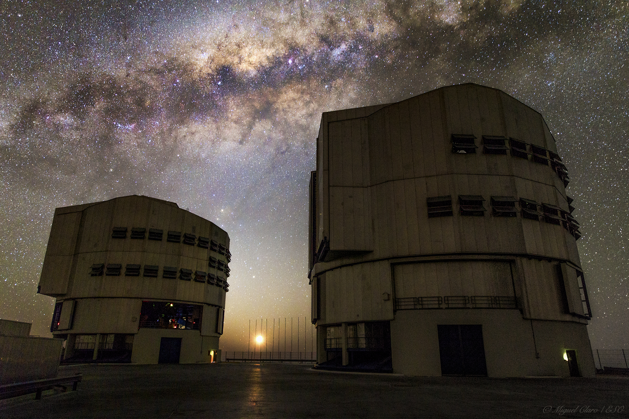
In this close-up of the central region of the Milky Way full of gas and dust, star clusters and emission nebulae, lies as the perfect background for the both VLT telescopes Antu (UT1) and Kueyen (UT2 ). In Mapuche language, Antu means “The Sun” and Kueyen “The Moon”, two names that are matching perfectly with the sunny appearance of this bright moonset, reflected in the floor of the VLT platform.
The Very Large Telescope (VLT) is a telescope operated by the ESO – European Southern Observatory on Cerro Paranal in the Atacama Desert of northern Chile. The VLT is the world’s most advanced optical instrument, consisting of four Unit Telescopes with main mirrors of 8.2m diameter, which are generally used separately but can be used together to achieve very high angular resolution. The four separate optical telescopes are known as Antu, Kueyen, Melipal (UT3 – “The Southern Cross”) and Yepun (UT4 – Venus “as evening star”), which are all words for astronomical objects in the Mapuche language, with optical elements that can combine them into an astronomical interferometer (VLTI), which is used to resolve small objects. The interferometer is complemented by four movable Auxiliary Telescopes (ATs) of 1.8 m aperture. The 8.2m diameter Unit Telescopes can also be used individually. With one such telescope, images of celestial objects as faint as magnitude 30 can be obtained in a one-hour exposure. This corresponds to seeing objects that are four billion (four thousand million) times fainter than what can be seen with the unaided eye. The telescopes can work together, to form a giant ‘interferometer’, the ESO Very Large Telescope Interferometer, allowing astronomers to see details up to 25 times finer than with the individual telescopes. The light beams are combined in the VLTI using a complex system of mirrors in underground tunnels where the light paths must be kept equal to distances less than 1/1000 mm over a hundred metres. With this kind of precision the VLTI can reconstruct images with an angular resolution of milliarcseconds, equivalent to distinguishing the two headlights of a car at the distance of the Moon.
Image taken taken in 15/10/2015 from Cerro Paranal, Atacama desert, Chile.
Enjoying Venus corona above the Giant´s Causeway – Northen Ireland

In the image we can see a Skygazer enjoying the planet venus with a visible corona phenomenon between the Giant’s Causeway, near Bushmills, in northeast coast of Northen Ireland. Is an area of about 40,000 interlocking basalt columns, the result of an ancient volcanic eruption, 60 million years ago. It was declared a World Heritage Site byUNESCO in 1986. Near the top edge of the image we can see the Pleiades star cluster.
Corona, is produced by the diffraction of light from either the Sun, the Moon or some bright planets by individual small water droplets and sometimes tiny ice crystals of a cloud.
ISO 2000, 30 sec, 16mm at f/2.8. In 20/03/2015 at 20:17
Polar Startrail in the Arms of a Noudar Tree

EN: Tracking deeply the stars simultaneously revealing the different brightness intensity and color of each star that lies around the North Star Polaris, which is 0.7 degrees fom the true north. If our ancestors who braved storms in uncharted waters to prove that the earth was really round, had the opportunity to make a simple photograph like that, then would have the living proof that the Earth was round without having run that risk, thus prove the curvature of stellar trails | Sky of Barrancos
Included in the great Alqueva Dark Sky Reserve – first site in the world to receive the “Starlight Tourism Destination” certification – Noudar Natural Park is located in a farm estate called Herdade da Coitadinha spreads across 1000 hectare, ‘over-the-hills’ between the winding rivers Ardila and Múrtega and lodged among hills and summits near the town of Barrancos (Alentejo, Portugal) and in the border with Spain. The road from the Park’s entrance to the Noudar Castle goes through an extensive holm oak grove (‘montado’) area, ending with a majestic view over the water lines. In Noudar, life presents itself in a state of wilderness and absolute purity.
More about Alqueva Dark Sky Reserve: Alqueva is the first site in the world to receive the “Starlight Tourism Destination” certification. This certification, awarded by the Starlight Foundation is supported by UNESCO, UNWTO and IAC. Starlight destinations are visitable places characterized by excellent quality for the contemplation of starry skies, and the practice of tourist activities based on this resource. www.darkskyalqueva.com
PT: Rasto de estrelas profundo, revelando simultaneamente as diferentes intensidades de brilho e cor de cada uma das estrelas que se encontra a circundar a Estrela Polar, que se encontra a 0,7 graus do Norte real. Se os nossos antepassados que enfrentaram intempéries nos mares nunca dantes navegados para provar que a terra era redonda, tivessem a oportunidade de fazer uma simples fotografia destas nessa altura, teriam a prova viva que a Terra era redonda sem precisar de ter corrido esse risco, assim comprova a curvatura dos traços estelares | Céu de Barrancos


