
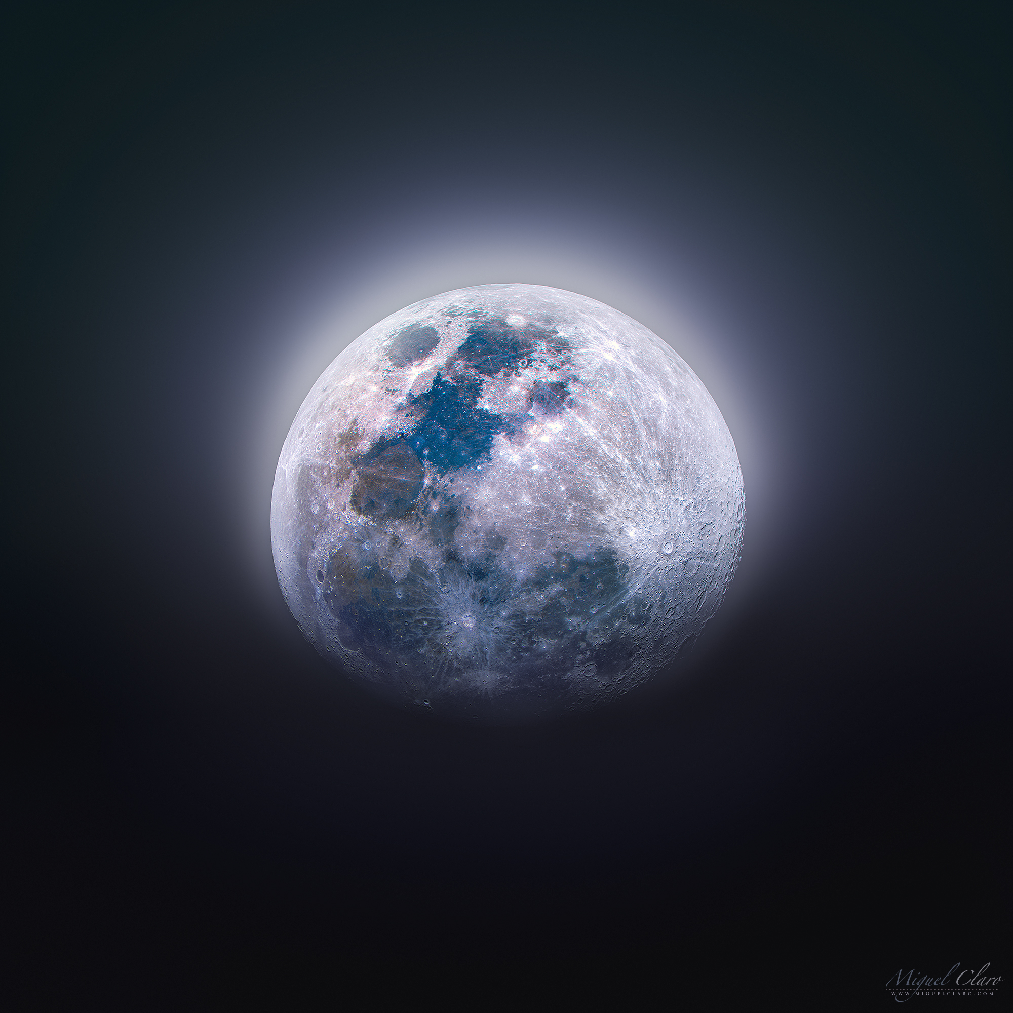
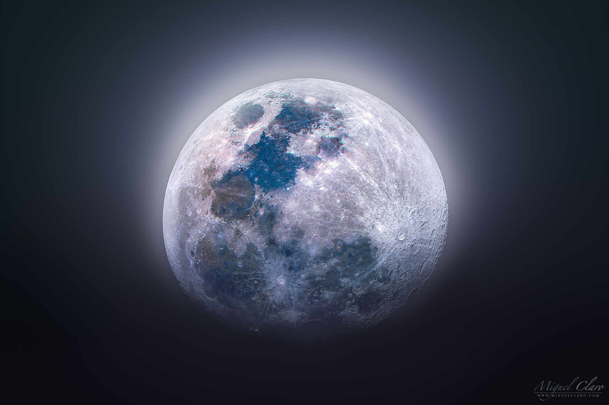
The Enchanting Light of a Waxing Gibbous Titanium Moon
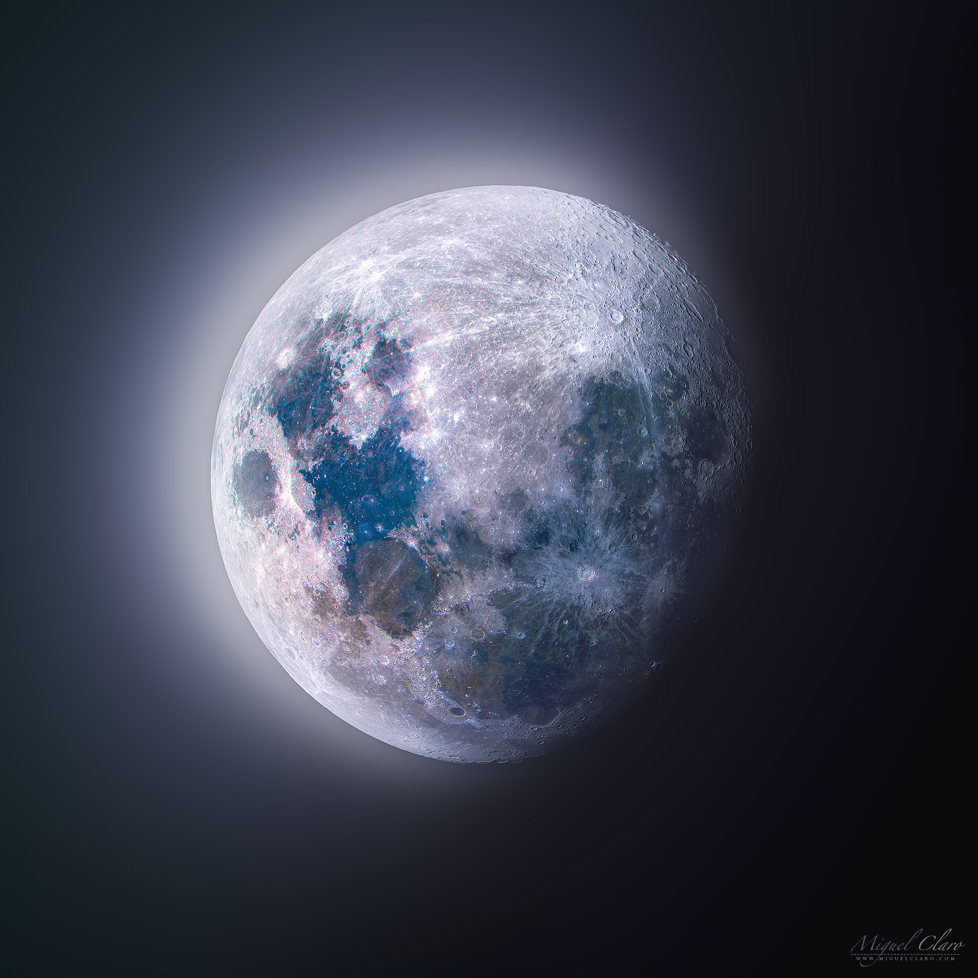
I love the Moon and to celebrate the achievement of Artemis II mission I decided to get back to the Moon myself and photograph it, revealling the beauty of a Waxing Gibbous Moon as an HDR scene captured on 1st March 2026 with the new Edge11 and a Poseidon-C Pro camera. The moon is more then a grey body as it is normally perceived by our human eye. The color of this RGB image have been slightly increased revelling a strange but even so, real appearance, corresponding to the differences in the chemical constitution of the lunar surface, as changes in mineral content can produce subtle color differences in reflected light. The blue hues that can be seen on the seas like “Mare Tranquillitatis”, or “Mare Fecunditatis” are revelling rich areas in titanium. According to Hawai’s Institute of Geophysics and Planetology, the presence of this unusual titanium-rich layer was produced by the crystallization of a huge ocean of magma that surrounded the Moon when it formed. In the bottom center of the Moon, white stripes are radiating across the southern lunar highlands, coming from the 85 kilometer wide crater Tycho. In the past, multicolor images calibrated by rock samples from the Apollo missions, were recorded by Galileo and Celmentine spacecrafts and been used to explore the Moon’s global surface composition.
PT: Adoro a Lua e para celebrar o sucesso da missão Artemis II, decidi voltar à Lua e fotografá-la, revelando a beleza de uma Lua crescente gibosa numa cena HDR captada a 1 de março de 2026 com o novo Edge11 e uma câmara Poseidon-C Pro. A Lua é mais do que um corpo cinzento como normalmente a percebemos. A cor desta imagem RGB foi ligeiramente realçada, revelando um aspeto estranho, mas ainda assim real, que corresponde às diferenças na composição química da superfície lunar, uma vez que as alterações no conteúdo mineral podem produzir subtis diferenças de cor na luz refletida. Os tons azuis que podem ser observados em mares como o “Mare Tranquillitatis” ou o “Mare Fecunditatis” revelam áreas ricas em titânio. De acordo com o Hawai’s Institute of Geophysics and Planetology, a presença dessa camada incomum rica em titânio foi produzida pela cristalização de um enorme oceano de magma que cercou a Lua quando ela se formou. No centro da Lua, faixas esbranquiçadas espalham-se de forma raiada pelas terras altas lunares do sul, vindas da cratera Tycho, com 85 quilómetros de largura. No passado, imagens multi-coloridas calibradas por amostras de rochas das missões Apollo foram registadas pelas sondas espaciais Galileo e Celmentine e usadas para explorar a composição da superfície global da Lua.
Technical details | Detalhes Técnicos
Celestron EDGE HD 11″ | Poseidon-C Pro Camera from Player One Astronomy | SW CQ350 | Mosaic of two panels composed by 200 images each. Cumeada Observatory from Dark Sky® Alqueva Reserve, Reguengos de Monsaraz.
BUY THIS PRINT | COMPRAR ESTA IMPRESSÃO
Buy a Fine Art Print or Wall Decor of this Image – Make your order Now!
You can choose the best style of print do you preffer to decorate in a fashion way your walls. Metal Prints with durable and vivid colors, Acrylic, Canvas or the highest quality Gallery Print – a 6 colour UV direct printing on acrylic glass (2mm) including light colours and reinforced by an aluminium dibond plate (3mm). Those type of Prints can highlight the final work in an artistic way, showing the photograph as a piece of art. I work with two high quality specialized Labs in US and in Europe, using Kodak Professional Endura Premier Metallic papers and Fujifilm Crystal Archive DP II Professional. You can select the image above or freely navigate to more than 800 photographs available in my gallery – each one with their own story and magic – and choose the photograph you would love to have in your home or office.
How to Order – Simple and easy, just “copy and paste” the link of this page or the image you choosed and fill it in the form below, with the size you want and any detail you wish to include on the message, like your country, name and postal address. Free Shipping included to all prints (except frames). For US and Europe the delivery is 4-8 working days, while to Portugal and Spain is normally 2-6 working days. After submitting the order through the form, I will contact you for the payment method (Paypal available or bank transfer) and with other questions related to your print(s) or requests. Once payment is confirmed, your order is shipped within 24h. In case you wish, I can send you separtely with no additional cost, a postcard autographed and numbered of the same image you have just bought, as a seal and proof of art work authenticity from the author. Let me know what is your wish.
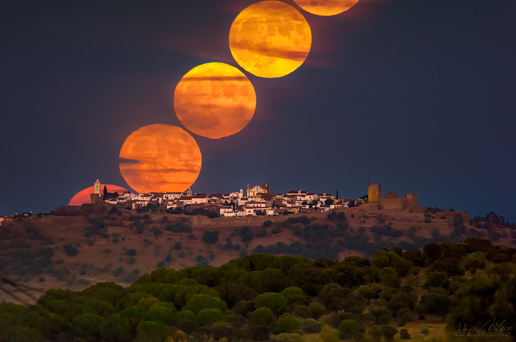
Traces of Light from Time and Space
Over the course of 6h I caught the full moon motion against the background starry sky above our Dark Sky® Alqueva Observatory. Traces of light that shows how time and space are deeply connected.
PT: Ao longo de 6 horas, fotografei o movimento da lua cheia contra o céu estrelado acima do nosso Observatório Oficial no Dark Sky® Alqueva, em Portugal. Traços de luz que mostram como o tempo e o espaço estão profundamente ligados.
BUY THIS PRINT | COMPRAR ESTA IMPRESSÃO
Buy a Fine Art Print or Wall Decor of this Image – Make your order Now!
You can choose the best style of print do you preffer to decorate in a fashion way your walls. Metal Prints with durable and vivid colors, Acrylic, Canvas or the highest quality Gallery Print – a 6 colour UV direct printing on acrylic glass (2mm) including light colours and reinforced by an aluminium dibond plate (3mm). Those type of Prints can highlight the final work in an artistic way, showing the photograph as a piece of art. I work with two high quality specialized Labs in US and in Europe, using Kodak Professional Endura Premier Metallic papers and Fujifilm Crystal Archive DP II Professional. You can select the image above or freely navigate to more than 800 photographs available in my gallery – each one with their own story and magic – and choose the photograph you would love to have in your home or office.
How to Order – Simple and easy, just “copy and paste” the link of this page or the image you choosed and fill it in the form below, with the size you want and any detail you wish to include on the message, like your country, name and postal address. Free Shipping included to all prints (except frames). For US and Europe the delivery is 4-8 working days, while to Portugal and Spain is normally 2-6 working days. After submitting the order through the form, I will contact you for the payment method (Paypal available or bank transfer) and with other questions related to your print(s) or requests. Once payment is confirmed, your order is shipped within 24h. In case you wish, I can send you separtely with no additional cost, a postcard autographed and numbered of the same image you have just bought, as a seal and proof of art work authenticity from the author. Let me know what is your wish.
Nostalgia with a Glimpse of our Future while Reaching out Other Distant Worlds like Mars

When one day we could reach other places in the Solar System…like Mars, nostalgia will come, specially when we realise that we no longer be able to watch our beautiful blue skies of Earth atmosphere. Instead, the rocky red planet Mars, will show a yellow pale glow on a dusty atmosphere and humans will not be able to breath and feel the outside air fresh on their skin. We are so lucky to be here…Now, in this small glimpse of the evolution of humankind! The time lapse was captured last year on the moonrise, from Mertola, at Dark Sky® Alqueva, in Portugal when my wife Apolónia Rodrigues was enjoying the moment, and for a second, seems to catch the Moon with her hand.
PT: Quando um dia pudermos alcançar outros lugares do Sistema Solar…como Marte, a nostalgia virá, principalmente quando percebermos que não voltará a ser possível contemplar os nossos belos céus azuis a partir da atmosfera terrestre. Em vez disso, o planeta vermelho e rochoso Marte mostrará um brilho amarelo pálido numa atmosfera poeirenta e os humanos não conseguirão respirar e sentir o ar fresco do exterior na sua pele. Temos muita sorte em estar aqui…agora, neste vislumbre passageiro da evolução humana! O time lapse foi captado no ano passado ao nascer da lua, em Mértola, no Dark Sky® Alqueva, quando a minha companheira Apolónia Rodrigues estava a desfrutar do momento e, por um segundo, “apanhou-a” com a sua mão.
BUY THIS PRINT| COMPRAR ESTA IMPRESSÃO
Buy a Fine Art Print or Wall Decor of this Image – Make your order Now!
You can choose the best style of print do you preffer to decorate in a fashion way your walls. Metal Prints with durable and vivid colors, Acrylic, Canvas or the highest quality Gallery Print – a 6 colour UV direct printing on acrylic glass (2mm) including light colours and reinforced by an aluminium dibond plate (3mm). Those type of Prints can highlight the final work in an artistic way, showing the photograph as a piece of art. I work with two high quality specialized Labs in US and in Europe, using Kodak Professional Endura Premier Metallic papers and Fujifilm Crystal Archive DP II Professional. You can select the image above or freely navigate to more than 800 photographs available in my gallery – each one with their own story and magic – and choose the photograph you would love to have in your home or office.
How to Order – Simple and easy, just “copy and paste” the link of this page or the image you choosed and fill it in the form below, with the size you want and any detail you wish to include on the message, like your country, name and postal address. Free Shipping included to all prints (except frames). For US and Europe the delivery is 4-8 working days, while to Portugal and Spain is normally 2-6 working days. After submitting the order through the form, I will contact you for the payment method (Paypal available or bank transfer) and with other questions related to your print(s) or requests. Once payment is confirmed, your order is shipped within 24h. In case you wish, I can send you separtely with no additional cost, a postcard autographed and numbered of the same image you have just bought, as a seal and proof of art work authenticity from the author. Let me know what is your wish.
Total Lunar Eclipse Over the Atlantic Ocean revealing a Lunar Corona

Views of the last Total Lunar Eclipse, with an eclipsed Moon immersed in a layer of iridescent clouds, revealing a Lunar Corona over the Atlantic Ocean, as seen from Costa da Caparica, Portugal. Below a time lapse sequence as a Reel, show the event in motion.
PT: Vista do último Eclipse Lunar Total, com uma Lua parcialmente eclipsada imersa numa camada de nuvens iridescentes, revelando uma Coroa Lunar sobre o Oceano Atlântico, captada a partir da Costa da Caparica, Portugal. Em baixo, um time lapse em forma de Reel revela o evento celeste em movimento.
BUY THIS PRINT | COMPRAR ESTA IMPRESSÃO
Buy a Fine Art Print or Wall Decor of this Image – Make your order Now!
You can choose the best style of print do you preffer to decorate in a fashion way your walls. Metal Prints with durable and vivid colors, Acrylic, Canvas or the highest quality Gallery Print – a 6 colour UV direct printing on acrylic glass (2mm) including light colours and reinforced by an aluminium dibond plate (3mm). Those type of Prints can highlight the final work in an artistic way, showing the photograph as a piece of art. I work with two high quality specialized Labs in US and in Europe, using Kodak Professional Endura Premier Metallic papers and Fujifilm Crystal Archive DP II Professional. You can select the image above or freely navigate to more than 800 photographs available in my gallery – each one with their own story and magic – and choose the photograph you would love to have in your home or office.
How to Order – Simple and easy, just “copy and paste” the link of this page or the image you choosed and fill it in the form below, with the size you want and any detail you wish to include on the message, like your country, name and postal address. Free Shipping included to all prints (except frames). For US and Europe the delivery is 4-8 working days, while to Portugal and Spain is normally 2-6 working days. After submitting the order through the form, I will contact you for the payment method (Paypal available or bank transfer) and with other questions related to your print(s) or requests. Once payment is confirmed, your order is shipped within 24h. In case you wish, I can send you separtely with no additional cost, a postcard autographed and numbered of the same image you have just bought, as a seal and proof of art work authenticity from the author. Let me know what is your wish.
Partial Total Lunar Eclipse 2025 Over the Atlantic Ocean as seen from Portugalt

Views of the last Total Lunar Eclipse over the Atlantic Ocean, almost reaching the maximum visibility – in between the clouds – and under the morning nautical twilight as seen from Costa da Caparica, Portugal. Below a time lapse sequence as a Reel, show the event in motion.
PT: Vista do último Eclipse Lunar Total sobre o Oceano Atlântico, quase a atingir a visibilidade máxima – por entre as nuvens – e sob o crepúsculo náutico matinal, captado a partir da Costa da Caparica, Portugal. Em baixo, um time lapse em forma de Reel revela o evento celeste em movimento.


BUY THIS PRINT | COMPRAR ESTA IMPRESSÃO
Buy a Fine Art Print or Wall Decor of this Image – Make your order Now!
You can choose the best style of print do you preffer to decorate in a fashion way your walls. Metal Prints with durable and vivid colors, Acrylic, Canvas or the highest quality Gallery Print – a 6 colour UV direct printing on acrylic glass (2mm) including light colours and reinforced by an aluminium dibond plate (3mm). Those type of Prints can highlight the final work in an artistic way, showing the photograph as a piece of art. I work with two high quality specialized Labs in US and in Europe, using Kodak Professional Endura Premier Metallic papers and Fujifilm Crystal Archive DP II Professional. You can select the image above or freely navigate to more than 800 photographs available in my gallery – each one with their own story and magic – and choose the photograph you would love to have in your home or office.
How to Order – Simple and easy, just “copy and paste” the link of this page or the image you choosed and fill it in the form below, with the size you want and any detail you wish to include on the message, like your country, name and postal address. Free Shipping included to all prints (except frames). For US and Europe the delivery is 4-8 working days, while to Portugal and Spain is normally 2-6 working days. After submitting the order through the form, I will contact you for the payment method (Paypal available or bank transfer) and with other questions related to your print(s) or requests. Once payment is confirmed, your order is shipped within 24h. In case you wish, I can send you separtely with no additional cost, a postcard autographed and numbered of the same image you have just bought, as a seal and proof of art work authenticity from the author. Let me know what is your wish.
Northern Lights Under the Moonlight above Alqueva Lake at 38º Latitude, Portugal

Captured on 10th of October, 2024, the panoramic image reveals an impressive display of northern lights in the presence of moonlight as seen from my location at 38º in Dark Sky® Alqueva, Portugal. I and Apolónia, we both could see them with naked eye around midnight. The weather was not perfect and a bit cloudy, but it ended up creating an even more dramatic and spectacular display over Monsaraz Castle and lake Alqueva.
PT: Captada em 10 de Outubro de 2024, a imagem panorâmica revela uma impressionante exibição das auroras boreais na presença do luar, vistas a partir da minha localização a 38º no Dark Sky® Alqueva, Portugal. Eu e a Apolónia pudemos inclusivamente observá-las a olho nu de forma subtil, por volta da meia-noite. O tempo não estava perfeito e um pouco nublado, mas acabou por criar uma exibição ainda mais dramática e espectacular sobre o Castelo de Monsaraz e o Grande Lago Alqueva.
BUY THIS PRINT | COMPRAR ESTA IMPRESSÃO
Buy a Fine Art Print or Wall Decor of this Image – Make your order Now!
You can choose the best style of print do you preffer to decorate in a fashion way your walls. Metal Prints with durable and vivid colors, Acrylic, Canvas or the highest quality Gallery Print – a 6 colour UV direct printing on acrylic glass (2mm) including light colours and reinforced by an aluminium dibond plate (3mm). Those type of Prints can highlight the final work in an artistic way, showing the photograph as a piece of art. I work with two high quality specialized Labs in US and in Europe, using Kodak Professional Endura Premier Metallic papers and Fujifilm Crystal Archive DP II Professional. You can select the image above or freely navigate to more than 800 photographs available in my gallery – each one with their own story and magic – and choose the photograph you would love to have in your home or office.
How to Order – Simple and easy, just “copy and paste” the link of this page or the image you choosed and fill it in the form below, with the size you want and any detail you wish to include on the message, like your country, name and postal address. Free Shipping included to all prints (except frames). For US and Europe the delivery is 4-8 working days, while to Portugal and Spain is normally 2-6 working days. After submitting the order through the form, I will contact you for the payment method (Paypal available or bank transfer) and with other questions related to your print(s) or requests. Once payment is confirmed, your order is shipped within 24h. In case you wish, I can send you separtely with no additional cost, a postcard autographed and numbered of the same image you have just bought, as a seal and proof of art work authenticity from the author. Let me know what is your wish.
Peacock Sleeping on a Tree Under a Colorful Lunar Corona Lit by a Super Blue Moon

The image shows a peacock sleeping in a tree in Punta Cana, Dominican Republic, in a special night on 20th August 2024, when the second full Moon of the Month happened, and for being as well at perigee was also called a Super Blue Moon. The single shot, also shows the background sky with high clouds covering the unfocused moon, while revealing the iridescence of a colorful corona surrounding our natural satellite. I was surprised to see a tree full of peacocks, I din’t knew that they were sleeping on trees to protect themselves from predators. Even not being well visible on the image, the peacock had by its side one little offspring, which I only noticed by the end of my capture. NatGeo explains that the term “peacock” is commonly used to refer to birds of both sexes. Technically, only males are peacocks. Females are peahens, and together, they are called peafowl. Peacocks are large, colorful pheasants (typically blue and green) known for their iridescent tails.The two Asiatic species are the blue or Indian peafowl originally from the Indian subcontinent, and the green peafowl from Southeast Asia. According to wikipedia, the Ancient Greeks believed that the flesh of peafowl did not decay after death, so it became a symbol of immortality. In Hellenistic imagery, the Greek goddess Hera’s chariot was pulled by peacocks, birds not known to Greeks before the conquests of Alexander. Alexander’s tutor, Aristotle, refers to it as “the Persian bird”. When Alexander saw the birds in India, he was so amazed at their beauty that he threatened the severest penalties for any man who slew one. Claudius Aelianus writes that there were peacocks in India, larger than anywhere else. In Christianity, the peacock can also symbolise the cosmos if one interprets its tail with its many “eyes” as the vault of heaven dotted by the sun, moon, and stars. Due to the adoption by Augustine of the ancient idea that the peacock’s flesh did not decay, the bird was again associated with immortality.
PT: A imagem mostra um pavão a dormir numa árvore em Punta Cana, República Dominicana, numa noite especial de 20 de agosto de 2024, quando ocorreu a segunda Lua Cheia do mês, e por estar também no perigeu foi também chamada de Super Lua Azul. A imagem de disparo único, mostra também o céu em pano de fundo com nuvens altas a cobrir a lua desfocada, enquanto revela a iridescência de uma coroa lunar visivíel em torno do nosso satélite natural. Fiquei surpreendido ao ver uma árvore cheia de pavões, não sabia que dormiam nas árvores para se protegerem dos predadores. Embora não seja claramente visível, este pavão tinha ainda a sua cria ao lado. So no final da captação de imagens é que me apercebi da sua pequena companhia. A NatGeo explica que o termo “pavão” é commumente utilizado para se referir a aves de ambos os sexos. Tecnicamente, só os machos são pavões. As fêmeas são pavoas e, em conjunto, são chamadas de pavões. Os pavões são faisões grandes e coloridos (normalmente azuis e verdes), conhecidos pelas suas caudas iridescentes. As duas espécies asiáticas são o pavão azul ou Indiano, originário do subcontinente Indiano, e o pavão verde, do Sudeste Asiático. Segundo a Wikipédia, na antiga grécia acreditava-se que a carne do pavão não se decompunha após a morte, pelo que se tornou um símbolo da imortalidade. Nas imagens helenísticas, o carro da deusa grega Hera era puxado por pavões, aves desconhecidas pelos gregos antes das conquistas de Alexandre. O tutor de Alexandre, Aristóteles, refere-se a ele como “o pássaro persa”. Quando Alexandre viu os pássaros na Índia, ficou tão impressionado com a sua beleza que ameaçou com as mais severas penas a qualquer homem que matasse um deles. Cláudio Aelianus escreve que existiam pavões na Índia, maiores do que em qualquer outro lugar. No Cristianismo, o pavão pode também simbolizar o Cosmos se interpretarmos a sua cauda com os seus muitos “olhos” como a abóbada celeste pontilhada pelo sol, pela lua e pelas estrelas. Devido à adoção por Agostinho da antiga ideia de que a carne do pavão não se decompunha, a ave foi novamente associada à imortalidade.

BUY THIS PRINT | COMPRAR ESTA IMPRESSÃO
Buy a Fine Art Print or Wall Decor of this Image – Make your order Now!
You can choose the best style of print do you preffer to decorate in a fashion way your walls. Metal Prints with durable and vivid colors, Acrylic, Canvas or the highest quality Gallery Print – a 6 colour UV direct printing on acrylic glass (2mm) including light colours and reinforced by an aluminium dibond plate (3mm). Those type of Prints can highlight the final work in an artistic way, showing the photograph as a piece of art. I work with two high quality specialized Labs in US and in Europe, using Kodak Professional Endura Premier Metallic papers and Fujifilm Crystal Archive DP II Professional. You can select the image above or freely navigate to more than 800 photographs available in my gallery – each one with their own story and magic – and choose the photograph you would love to have in your home or office.
How to Order – Simple and easy, just “copy and paste” the link of this page or the image you choosed and fill it in the form below, with the size you want and any detail you wish to include on the message, like your country, name and postal address. Free Shipping included to all prints (except frames). For US and Europe the delivery is 4-8 working days, while to Portugal and Spain is normally 2-6 working days. After submitting the order through the form, I will contact you for the payment method (Paypal available or bank transfer) and with other questions related to your print(s) or requests. Once payment is confirmed, your order is shipped within 24h. In case you wish, I can send you separtely with no additional cost, a postcard autographed and numbered of the same image you have just bought, as a seal and proof of art work authenticity from the author. Let me know what is your wish.
Peacock Sleeping on a Tree Under the Super Blue Moonlight

The image shows a peacock sleeping in a tree in Punta Cana, Dominican Republic, in a special night on 20th August 2024, when the second full Moon of the Month happened, and for being as well at perigee was also called a Super Blue Moon. The single shot, also shows the background sky with high clouds covering the unfocused moon. I was surprised to see a tree full of peacocks, I din’t knew that they were sleeping on trees to protect themselves from predators. Even not being well visible on the image, the peacock had by its side one little offspring, which I only noticed by the end of my capture. NatGeo explains that the term “peacock” is commonly used to refer to birds of both sexes. Technically, only males are peacocks. Females are peahens, and together, they are called peafowl. Peacocks are large, colorful pheasants (typically blue and green) known for their iridescent tails.The two Asiatic species are the blue or Indian peafowl originally from the Indian subcontinent, and the green peafowl from Southeast Asia. According to wikipedia, the Ancient Greeks believed that the flesh of peafowl did not decay after death, so it became a symbol of immortality. In Hellenistic imagery, the Greek goddess Hera’s chariot was pulled by peacocks, birds not known to Greeks before the conquests of Alexander. Alexander’s tutor, Aristotle, refers to it as “the Persian bird”. When Alexander saw the birds in India, he was so amazed at their beauty that he threatened the severest penalties for any man who slew one. Claudius Aelianus writes that there were peacocks in India, larger than anywhere else. In Christianity, the peacock can also symbolise the cosmos if one interprets its tail with its many “eyes” as the vault of heaven dotted by the sun, moon, and stars. Due to the adoption by Augustine of the ancient idea that the peacock’s flesh did not decay, the bird was again associated with immortality.
PT: A imagem mostra um pavão a dormir numa árvore em Punta Cana, República Dominicana, numa noite especial de 20 de agosto de 2024, quando ocorreu a segunda Lua Cheia do mês, e por estar também no perigeu foi também chamada de Super Lua Azul. A imagem de disparo único, mostra também o céu de fundo com nuvens altas a cobrir a lua desfocada. Fiquei surpreendido ao ver uma árvore cheia de pavões, não sabia que dormiam nas árvores para se protegerem dos predadores. Embora não seja claramente visível, este pavão tinha ainda a sua cria ao lado. So no final da captação de imagens é que me apercebi da sua pequena companhia. A NatGeo explica que o termo “pavão” é commumente utilizado para se referir a aves de ambos os sexos. Tecnicamente, só os machos são pavões. As fêmeas são pavoas e, em conjunto, são chamadas de pavões. Os pavões são faisões grandes e coloridos (normalmente azuis e verdes), conhecidos pelas suas caudas iridescentes. As duas espécies asiáticas são o pavão azul ou Indiano, originário do subcontinente Indiano, e o pavão verde, do Sudeste Asiático. Segundo a Wikipédia, na antiga grécia acreditava-se que a carne do pavão não se decompunha após a morte, pelo que se tornou um símbolo da imortalidade. Nas imagens helenísticas, o carro da deusa grega Hera era puxado por pavões, aves desconhecidas pelos gregos antes das conquistas de Alexandre. O tutor de Alexandre, Aristóteles, refere-se a ele como “o pássaro persa”. Quando Alexandre viu os pássaros na Índia, ficou tão impressionado com a sua beleza que ameaçou com as mais severas penas a qualquer homem que matasse um deles. Cláudio Aelianus escreve que existiam pavões na Índia, maiores do que em qualquer outro lugar. No Cristianismo, o pavão pode também simbolizar o Cosmos se interpretarmos a sua cauda com os seus muitos “olhos” como a abóbada celeste pontilhada pelo sol, pela lua e pelas estrelas. Devido à adoção por Agostinho da antiga ideia de que a carne do pavão não se decompunha, a ave foi novamente associada à imortalidade.


BUY THIS PRINT | COMPRAR ESTA IMPRESSÃO
Buy a Fine Art Print or Wall Decor of this Image – Make your order Now!
You can choose the best style of print do you preffer to decorate in a fashion way your walls. Metal Prints with durable and vivid colors, Acrylic, Canvas or the highest quality Gallery Print – a 6 colour UV direct printing on acrylic glass (2mm) including light colours and reinforced by an aluminium dibond plate (3mm). Those type of Prints can highlight the final work in an artistic way, showing the photograph as a piece of art. I work with two high quality specialized Labs in US and in Europe, using Kodak Professional Endura Premier Metallic papers and Fujifilm Crystal Archive DP II Professional. You can select the image above or freely navigate to more than 800 photographs available in my gallery – each one with their own story and magic – and choose the photograph you would love to have in your home or office.
How to Order – Simple and easy, just “copy and paste” the link of this page or the image you choosed and fill it in the form below, with the size you want and any detail you wish to include on the message, like your country, name and postal address. Free Shipping included to all prints (except frames). For US and Europe the delivery is 4-8 working days, while to Portugal and Spain is normally 2-6 working days. After submitting the order through the form, I will contact you for the payment method (Paypal available or bank transfer) and with other questions related to your print(s) or requests. Once payment is confirmed, your order is shipped within 24h. In case you wish, I can send you separtely with no additional cost, a postcard autographed and numbered of the same image you have just bought, as a seal and proof of art work authenticity from the author. Let me know what is your wish.
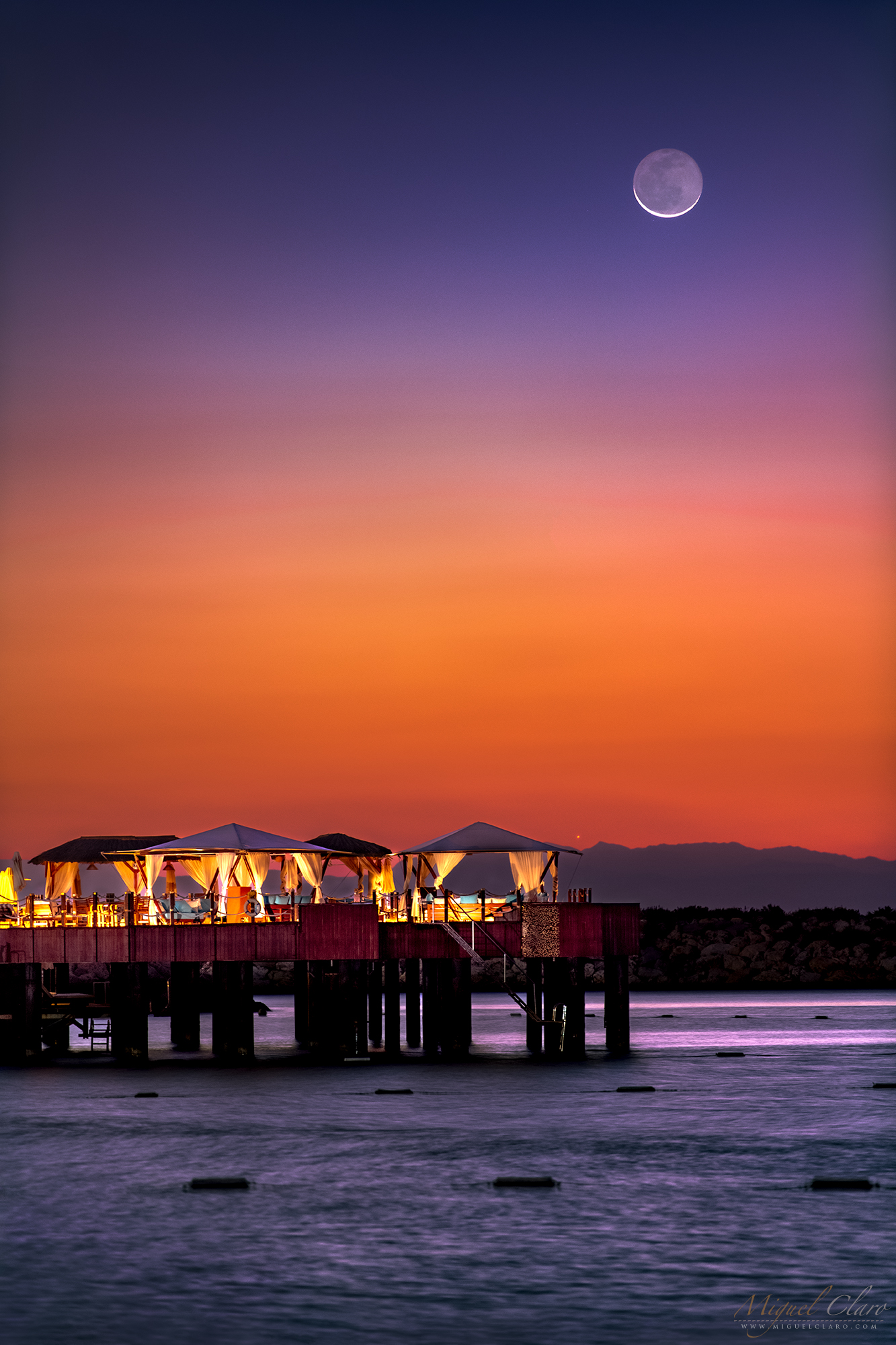
A Swing “Between” Crescent Moon and Venus under the Twilight Colors

Captured at the end of nautical twilight, the image reveals a wonderful celestial encounter with the crescent Moon visible only 4.5º apart from planet Venus, shining this time of the year (September) in the western sky as the “Evening Star”. In the foreground, a stargazer enjoys the celestial view while relaxing in a swing made of wood, located in Estremoz, the most recent region joining the Dark Sky® Alqueva certified territory, in Portugal.
PT: Captado no final do crepúsculo náutico, a imagem revela um encontro celeste colorido com a lua crescente visível a apenas 4,5º de distância do planeta Vénus, que brilha nesta altura do ano como a “Estrela da Tarde”, no céu Oeste. Em primeiro plano, uma stargazer desfruta desta visão cósmica enquanto relaxa num baloiço feito de madeira, localizado no concelho de Estremoz, a região que mais recentemente integrou o território já certificado do Dark Sky® Alqueva, Portugal.
BUY THIS PRINT | COMPRAR ESTA IMPRESSÃO
Buy a Fine Art Print or Wall Decor of this Image – Make your order Now!
You can choose the best style of print do you preffer to decorate in a fashion way your walls. Metal Prints with durable and vivid colors, Acrylic, Canvas or the highest quality Gallery Print – a 6 colour UV direct printing on acrylic glass (2mm) including light colours and reinforced by an aluminium dibond plate (3mm). Those type of Prints can highlight the final work in an artistic way, showing the photograph as a piece of art. I work with two high quality specialized Labs in US and in Europe, using Kodak Professional Endura Premier Metallic papers and Fujifilm Crystal Archive DP II Professional. You can select the image above or freely navigate to more than 800 photographs available in my gallery – each one with their own story and magic – and choose the photograph you would love to have in your home or office.
How to Order – Simple and easy, just “copy and paste” the link of this page or the image you choosed and fill it in the form below, with the size you want and any detail you wish to include on the message, like your country, name and postal address. Free Shipping included to all prints (except frames). For US and Europe the delivery is 4-8 working days, while to Portugal and Spain is normally 2-6 working days. After submitting the order through the form, I will contact you for the payment method (Paypal available or bank transfer) and with other questions related to your print(s) or requests. Once payment is confirmed, your order is shipped within 24h. In case you wish, I can send you separtely with no additional cost, a postcard autographed and numbered of the same image you have just bought, as a seal and proof of art work authenticity from the author. Let me know what is your wish.
MilkyWay Under the Moonlight in a Time Lapse Footage

Summer nights are now fullfilled with the bright core of Milky Way, visible in the beginning of the night, if you are faced south and faraway from city lights. The short time lapse sequence feature the summer MilkyWay moving in the background starry sky while the Moon was setting in one of the golden fields near Alqueva’s lake, at Dark Sky® Alqueva preserve, in Portugal!
PT: As noites de verão são agora preenchidas com o núcleo brilhante da Via Láctea, visível ao início da noite, se estiver virado para sul e longe das luzes da cidade. A curta sequência de time-lapse mostra a Via Láctea de Verão a mover-se no fundo do céu estrelado enquanto a Lua se punha num dos campos dourados perto do lago de Alqueva, na reserva Dark Sky® Alqueva, em Portugal!
BUY THIS PRINT | COMPRAR ESTA IMPRESSÃO
Buy a Fine Art Print or Wall Decor of this Image – Make your order Now!
You can choose the best style of print do you preffer to decorate in a fashion way your walls. Metal Prints with durable and vivid colors, Acrylic, Canvas or the highest quality Gallery Print – a 6 colour UV direct printing on acrylic glass (2mm) including light colours and reinforced by an aluminium dibond plate (3mm). Those type of Prints can highlight the final work in an artistic way, showing the photograph as a piece of art. I work with two high quality specialized Labs in US and in Europe, using Kodak Professional Endura Premier Metallic papers and Fujifilm Crystal Archive DP II Professional. You can select the image above or freely navigate to more than 800 photographs available in my gallery – each one with their own story and magic – and choose the photograph you would love to have in your home or office.
How to Order – Simple and easy, just “copy and paste” the link of this page or the image you choosed and fill it in the form below, with the size you want and any detail you wish to include on the message, like your country, name and postal address. Free Shipping included to all prints (except frames). For US and Europe the delivery is 4-8 working days, while to Portugal and Spain is normally 2-6 working days. After submitting the order through the form, I will contact you for the payment method (Paypal available or bank transfer) and with other questions related to your print(s) or requests. Once payment is confirmed, your order is shipped within 24h. In case you wish, I can send you separtely with no additional cost, a postcard autographed and numbered of the same image you have just bought, as a seal and proof of art work authenticity from the author. Let me know what is your wish.
Strawberry Full Moon Rising above the Golden Fields of Dark Sky® Alqueva

Sometimes all we need is an excuse to come outside and just being under the nature during nighttime while enjoying a wonderful moonrise. The image and video shows the June’s “strawberry” full moon rising in one of the Dark Sky® Alqueva golden fields, in Portugal. The background nature sound was recorded live in the field when I was shooting the time lapse, then included in the final video.
PT: Às vezes, tudo o que precisamos é de uma desculpa para sair e ficar sob a natureza durante a noite enquanto desfrutamos de um maravilhoso nascer da lua. A imagem e vídeo mostram a lua cheia de Junho – mais conhecido por “Lua de Morango” acima de umas das paisagens douradas do Dark Sky® Alqueva, em Portugal. O som da natureza de fundo incluindo no video, foi gravado ao vivo, enquanto registava o nascimento da lua em time lapse.
BUY THIS PRINT | COMPRAR ESTA IMPRESSÃO
Buy a Fine Art Print or Wall Decor of this Image – Make your order Now!
You can choose the best style of print do you preffer to decorate in a fashion way your walls. Metal Prints with durable and vivid colors, Acrylic, Canvas or the highest quality Gallery Print – a 6 colour UV direct printing on acrylic glass (2mm) including light colours and reinforced by an aluminium dibond plate (3mm). Those type of Prints can highlight the final work in an artistic way, showing the photograph as a piece of art. I work with two high quality specialized Labs in US and in Europe, using Kodak Professional Endura Premier Metallic papers and Fujifilm Crystal Archive DP II Professional. You can select the image above or freely navigate to more than 800 photographs available in my gallery – each one with their own story and magic – and choose the photograph you would love to have in your home or office.
How to Order – Simple and easy, just “copy and paste” the link of this page or the image you choosed and fill it in the form below, with the size you want and any detail you wish to include on the message, like your country, name and postal address. Free Shipping included to all prints (except frames). For US and Europe the delivery is 4-8 working days, while to Portugal and Spain is normally 2-6 working days. After submitting the order through the form, I will contact you for the payment method (Paypal available or bank transfer) and with other questions related to your print(s) or requests. Once payment is confirmed, your order is shipped within 24h. In case you wish, I can send you separtely with no additional cost, a postcard autographed and numbered of the same image you have just bought, as a seal and proof of art work authenticity from the author. Let me know what is your wish.
Da Vinci Glow Shines on a Crescent Moon in Close Conjunction with Planet Jupiter

Captured on March 14th, 2024 the image reveals a close conjunction between Planet Jupiter and a Crescent Moon. While Jupiter revealed on this 300mm portrait its main 4 galilean moons, on the Crescent Moon is shiningly visible the Da Vinci Glow. Described and drawn for the first time by Leonardo Da Vinci about 500 years ago on his book Codex Leicester, Leonardo da Vinci explained the phenomenon known as Earthshine in the early 16th century, when he realised that both Earth and the Moon reflect sunlight at the same time. Light is reflected from the Earth to the Moon and back to the Earth as earthshine. The image was captured in one of the landscape fields from Dark Sky® Alqueva region, in Portugal.
PT: Captada a 14 de Março de 2024, a imagem revela uma estreita conjunção entre o planeta Júpiter e uma Lua Crescente. Enquanto Júpiter revela neste retrato de 300mm as suas 4 principais luas galileanas, na Lua Crescente é possível distinguir claramente o chamado “Brilho de Da Vinci”. Descrito e desenhado pela primeira vez por Leonardo Da Vinci há cerca de 500 anos em seu livro Codex Leicester, Leonardo da Vinci explicou o fenómeno conhecido como Earthshine (Da Vinci Glow) no início do século XVI, quando percebeu que tanto a Terra quanto a Lua refletem a luz solar ao mesmo tempo. A luz é refletida da Terra para a Lua e de volta para a Terra como Earthshine. A imagem foi captada numa das paisagens do Dark Sky® Alqueva, em Portugal.
BUY THIS PRINT | COMPRAR ESTA IMPRESSÃO
Buy a Fine Art Print or Wall Decor of this Image – Make your order Now!
You can choose the best style of print do you preffer to decorate in a fashion way your walls. Metal Prints with durable and vivid colors, Acrylic, Canvas or the highest quality Gallery Print – a 6 colour UV direct printing on acrylic glass (2mm) including light colours and reinforced by an aluminium dibond plate (3mm). Those type of Prints can highlight the final work in an artistic way, showing the photograph as a piece of art. I work with two high quality specialized Labs in US and in Europe, using Kodak Professional Endura Premier Metallic papers and Fujifilm Crystal Archive DP II Professional. You can select the image above or freely navigate to more than 800 photographs available in my gallery – each one with their own story and magic – and choose the photograph you would love to have in your home or office.
How to Order – Simple and easy, just “copy and paste” the link of this page or the image you choosed and fill it in the form below, with the size you want and any detail you wish to include on the message, like your country, name and postal address. Free Shipping included to all prints (except frames). For US and Europe the delivery is 4-8 working days, while to Portugal and Spain is normally 2-6 working days. After submitting the order through the form, I will contact you for the payment method (Paypal available or bank transfer) and with other questions related to your print(s) or requests. Once payment is confirmed, your order is shipped within 24h. In case you wish, I can send you separtely with no additional cost, a postcard autographed and numbered of the same image you have just bought, as a seal and proof of art work authenticity from the author. Let me know what is your wish.
Golden Fullmoon Immersed in a thin Layer of High Clouds Shines in January 2024

The image shows a golden full moon immersed in a layer of thin high clouds, few minutes after rising above Dark Sky® Alqueva region, in Portugal. The was the first fullmoon of 2024
PT: A imagem mostra uma lua cheia dourada imersa numa camada fina de nuvens altas, alguns minutos após nascer acima dos céus do Dark Sky® Alqueva, em Portugal. Esta foi a primeira lua cheia de 2024
BUY THIS PRINT | COMPRAR ESTA IMPRESSÃO
Buy a Fine Art Print or Wall Decor of this Image – Make your order Now!
You can choose the best style of print do you preffer to decorate in a fashion way your walls. Metal Prints with durable and vivid colors, Acrylic, Canvas or the highest quality Gallery Print – a 6 colour UV direct printing on acrylic glass (2mm) including light colours and reinforced by an aluminium dibond plate (3mm). Those type of Prints can highlight the final work in an artistic way, showing the photograph as a piece of art. I work with two high quality specialized Labs in US and in Europe, using Kodak Professional Endura Premier Metallic papers and Fujifilm Crystal Archive DP II Professional. You can select the image above or freely navigate to more than 800 photographs available in my gallery – each one with their own story and magic – and choose the photograph you would love to have in your home or office.
How to Order – Simple and easy, just “copy and paste” the link of this page or the image you choosed and fill it in the form below, with the size you want and any detail you wish to include on the message, like your country, name and postal address. Free Shipping included to all prints (except frames). For US and Europe the delivery is 4-8 working days, while to Portugal and Spain is normally 2-6 working days. After submitting the order through the form, I will contact you for the payment method (Paypal available or bank transfer) and with other questions related to your print(s) or requests. Once payment is confirmed, your order is shipped within 24h. In case you wish, I can send you separtely with no additional cost, a postcard autographed and numbered of the same image you have just bought, as a seal and proof of art work authenticity from the author. Let me know what is your wish.
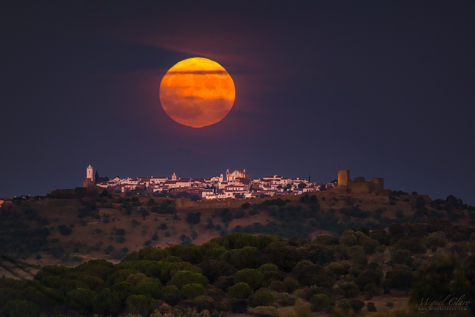
First Full Moon of the Year 2024 while Rising above Monsaraz Castle

The image shows the first Full Moon of the year 2024, with a layer of high cloud while the Moon was rising above Monsaraz castle at Dark Sky® Alqueva region, in Portugal. The image was captured 13km away from castle with 600mm lens.
PT: A imagem mostra a primeira Lua Cheia de 2024 com numa camada fina de nuvens altas enquanto esta nascia acima do castelo de Monsaraz, nos céus do Dark Sky® Alqueva, em Portugal. A imagem foi captada a 13km de distância do castelo com uma objectiva de 600mm.
BUY THIS PRINT | COMPRAR ESTA IMPRESSÃO
Buy a Fine Art Print or Wall Decor of this Image – Make your order Now!
You can choose the best style of print do you preffer to decorate in a fashion way your walls. Metal Prints with durable and vivid colors, Acrylic, Canvas or the highest quality Gallery Print – a 6 colour UV direct printing on acrylic glass (2mm) including light colours and reinforced by an aluminium dibond plate (3mm). Those type of Prints can highlight the final work in an artistic way, showing the photograph as a piece of art. I work with two high quality specialized Labs in US and in Europe, using Kodak Professional Endura Premier Metallic papers and Fujifilm Crystal Archive DP II Professional. You can select the image above or freely navigate to more than 800 photographs available in my gallery – each one with their own story and magic – and choose the photograph you would love to have in your home or office.
How to Order – Simple and easy, just “copy and paste” the link of this page or the image you choosed and fill it in the form below, with the size you want and any detail you wish to include on the message, like your country, name and postal address. Free Shipping included to all prints (except frames). For US and Europe the delivery is 4-8 working days, while to Portugal and Spain is normally 2-6 working days. After submitting the order through the form, I will contact you for the payment method (Paypal available or bank transfer) and with other questions related to your print(s) or requests. Once payment is confirmed, your order is shipped within 24h. In case you wish, I can send you separtely with no additional cost, a postcard autographed and numbered of the same image you have just bought, as a seal and proof of art work authenticity from the author. Let me know what is your wish.
Sequence of a Super “Blue” Moon 2023 Rising Over Monsaraz Castle
A sequence of single shot shows a Super Full “Blue” Moon which don’t have nothing of blue, rising above Monsaraz castle at Dark Sky® Alqueva, in Portugal. Blue Moon is just called when two full moons happen in the same month. Supermoons happen when a full moon approximately coincides with the moon’s perigee, or a point in its orbit at which it is closest to Earth. This makes the moon appear larger and brighter than usual. Below is a time lapse of this singular moment, to watch with sound on.
PT: A sequência de disparos únicos, revela o caminho da Super Lua Cheia “Azul” – que não tem nada de azul – nascendo sobre o castelo de Monsaraz, no Dark Sky® Alqueva, em Portugal. A “Blue Moon” é assim apelidada sempre que ocorre a segunda luz cheia no mesmo mês. As superluas ocorrem quando a lua cheia coincide aproximadamente com o perigeu, ponto da sua órbita mais próxima da Terra. Nesta alturas a lua parece maior e mais brilhante do que o normal. Em baixo é possível ver um time lapse deste momento singular, para ver com o som ligado.
BUY THIS PRINT | COMPRAR ESTA IMPRESSÃO
Buy a Fine Art Print or Wall Decor of this Image – Make your order Now!
You can choose the best style of print do you preffer to decorate in a fashion way your walls. Metal Prints with durable and vivid colors, Acrylic, Canvas or the highest quality Gallery Print – a 6 colour UV direct printing on acrylic glass (2mm) including light colours and reinforced by an aluminium dibond plate (3mm). Those type of Prints can highlight the final work in an artistic way, showing the photograph as a piece of art. I work with two high quality specialized Labs in US and in Europe, using Kodak Professional Endura Premier Metallic papers and Fujifilm Crystal Archive DP II Professional. You can select the image above or freely navigate to more than 800 photographs available in my gallery – each one with their own story and magic – and choose the photograph you would love to have in your home or office.
How to Order – Simple and easy, just “copy and paste” the link of this page or the image you choosed and fill it in the form below, with the size you want and any detail you wish to include on the message, like your country, name and postal address. Free Shipping included to all prints (except frames). For US and Europe the delivery is 4-8 working days, while to Portugal and Spain is normally 2-6 working days. After submitting the order through the form, I will contact you for the payment method (Paypal available or bank transfer) and with other questions related to your print(s) or requests. Once payment is confirmed, your order is shipped within 24h. In case you wish, I can send you separtely with no additional cost, a postcard autographed and numbered of the same image you have just bought, as a seal and proof of art work authenticity from the author. Let me know what is your wish.
Super “Blue” Moon 2023 Rising Over Monsaraz Castle – Photo and Time Lapse
A single shot shows a Super Full “Blue” Moon which don’t have nothing of blue, rising above Monsaraz castle at Dark Sky® Alqueva, in Portugal. Blue Moon is just called when two full moons happen in the same month. Supermoons happen when a full moon approximately coincides with the moon’s perigee, or a point in its orbit at which it is closest to Earth. This makes the moon appear larger and brighter than usual. Below is a time lapse of this singular moment, to watch with sound on.
PT: A imagem de um disparo único, revela a Super Lua Cheia “Azul” – que não tem nada de azul – nascendo sobre o castelo de Monsaraz, no Dark Sky® Alqueva, em Portugal. A “Blue Moon” é assim apelidada sempre que ocorre a segunda luz cheia no mesmo mês. As superluas ocorrem quando a lua cheia coincide aproximadamente com o perigeu, ponto da sua órbita mais próxima da Terra. Nesta alturas a lua parece maior e mais brilhante do que o normal. Em baixo é possível ver um time lapse deste momento singular, para ver com o som ligado.
BUY THIS PRINT | COMPRAR ESTA IMPRESSÃO
Buy a Fine Art Print or Wall Decor of this Image – Make your order Now!
You can choose the best style of print do you preffer to decorate in a fashion way your walls. Metal Prints with durable and vivid colors, Acrylic, Canvas or the highest quality Gallery Print – a 6 colour UV direct printing on acrylic glass (2mm) including light colours and reinforced by an aluminium dibond plate (3mm). Those type of Prints can highlight the final work in an artistic way, showing the photograph as a piece of art. I work with two high quality specialized Labs in US and in Europe, using Kodak Professional Endura Premier Metallic papers and Fujifilm Crystal Archive DP II Professional. You can select the image above or freely navigate to more than 800 photographs available in my gallery – each one with their own story and magic – and choose the photograph you would love to have in your home or office.
How to Order – Simple and easy, just “copy and paste” the link of this page or the image you choosed and fill it in the form below, with the size you want and any detail you wish to include on the message, like your country, name and postal address. Free Shipping included to all prints (except frames). For US and Europe the delivery is 4-8 working days, while to Portugal and Spain is normally 2-6 working days. After submitting the order through the form, I will contact you for the payment method (Paypal available or bank transfer) and with other questions related to your print(s) or requests. Once payment is confirmed, your order is shipped within 24h. In case you wish, I can send you separtely with no additional cost, a postcard autographed and numbered of the same image you have just bought, as a seal and proof of art work authenticity from the author. Let me know what is your wish.
Under the Nature to Enjoy the Supermoon of 1st August 2023

Sometimes all we need is an excuse to come outside and just being under the nature during nighttime while enjoying a wonderful super moonrise. Supermoons happen when a full moon approximately coincides with the moon’s perigee, or a point in its orbit at which it is closest to Earth. This makes the moon appear larger and brighter than usual. The 1st August 2023 was on of these moments. The single shot was captured in the beautiful landscape of Dark Sky® Alqueva territory, in Portugal.
PT: Às vezes, tudo o que precisamos é de uma desculpa para sair e ficar sob a natureza durante a noite enquanto desfrutamos de um maravilhoso nascer da lua. Superluas acontecem quando uma lua cheia coincide aproximadamente com o perigeu da lua, ou um ponto em sua órbita no qual ela está mais próxima da Terra. Isso faz com que a lua pareça maior e mais brilhante do que o normal. O dia 1 de agosto de 2023 foi um desses momentos. A foto de um disparo único, foi captada numa das românticas paisagens do território Dark Sky® Alqueva, em Portugal.
BUY THIS PRINT | COMPRAR ESTA IMPRESSÃO
Buy a Fine Art Print or Wall Decor of this Image – Make your order Now!
You can choose the best style of print do you preffer to decorate in a fashion way your walls. Metal Prints with durable and vivid colors, Acrylic, Canvas or the highest quality Gallery Print – a 6 colour UV direct printing on acrylic glass (2mm) including light colours and reinforced by an aluminium dibond plate (3mm). Those type of Prints can highlight the final work in an artistic way, showing the photograph as a piece of art. I work with two high quality specialized Labs in US and in Europe, using Kodak Professional Endura Premier Metallic papers and Fujifilm Crystal Archive DP II Professional. You can select the image above or freely navigate to more than 800 photographs available in my gallery – each one with their own story and magic – and choose the photograph you would love to have in your home or office.
How to Order – Simple and easy, just “copy and paste” the link of this page or the image you choosed and fill it in the form below, with the size you want and any detail you wish to include on the message, like your country, name and postal address. Free Shipping included to all prints (except frames). For US and Europe the delivery is 4-8 working days, while to Portugal and Spain is normally 2-6 working days. After submitting the order through the form, I will contact you for the payment method (Paypal available or bank transfer) and with other questions related to your print(s) or requests. Once payment is confirmed, your order is shipped within 24h. In case you wish, I can send you separtely with no additional cost, a postcard autographed and numbered of the same image you have just bought, as a seal and proof of art work authenticity from the author. Let me know what is your wish.
A Golden Full Moon After a Penumbral Lunar Eclipse

The image shows a golden full moon immersed in a layer of thin high clouds, while was rising after a penumbral lunar eclipse on May 5, which last for only a couple of minutes as it was seen from a marble exploration, in Alandroal, Dark Sky® Alqueva, Portugal.
PT: A imagem captada a 5 de Maio, mostra uma lua cheia dourada imersa numa camada de nuvens altas e finas, enquanto esta se elevava após um eclipse lunar penumbral que durou apenas alguns minutos, visto a partir de uma exploração de mármore, no Alandroal, Dark Sky® Alqueva, Portugal.
BUY THIS PRINT | COMPRAR ESTA IMPRESSÃO
Buy a Fine Art Print or Wall Decor of this Image – Make your order Now!
You can choose the best style of print do you preffer to decorate in a fashion way your walls. Metal Prints with durable and vivid colors, Acrylic, Canvas or the highest quality Gallery Print – a 6 colour UV direct printing on acrylic glass (2mm) including light colours and reinforced by an aluminium dibond plate (3mm). Those type of Prints can highlight the final work in an artistic way, showing the photograph as a piece of art. I work with two high quality specialized Labs in US and in Europe, using Kodak Professional Endura Premier Metallic papers and Fujifilm Crystal Archive DP II Professional. You can select the image above or freely navigate to more than 800 photographs available in my gallery – each one with their own story and magic – and choose the photograph you would love to have in your home or office.
How to Order – Simple and easy, just “copy and paste” the link of this page or the image you choosed and fill it in the form below, with the size you want and any detail you wish to include on the message, like your country, name and postal address. Free Shipping included to all prints (except frames). For US and Europe the delivery is 4-8 working days, while to Portugal and Spain is normally 2-6 working days. After submitting the order through the form, I will contact you for the payment method (Paypal available or bank transfer) and with other questions related to your print(s) or requests. Once payment is confirmed, your order is shipped within 24h. In case you wish, I can send you separtely with no additional cost, a postcard autographed and numbered of the same image you have just bought, as a seal and proof of art work authenticity from the author. Let me know what is your wish.
Earth Shadow – The Beauty of a Total Lunar Eclipse in Motion
A video time lapse in 4K shows what is the deepest feeling of experiencing the incredible moment when the moon passes through the Earth’s shadow, giving the natural satellite a blood-red hue during a total lunar eclipse. The stars around the moon are again visible as the light of the moon drops drastically, giving rise to a unique moment of seeing the mesmerising presence of the Milky Way but at the same time, the shinning moon reflecting a low reddish light for being immersed inside the Umbra of the Earth shadow. The movie also intend to reveal the emotional feeling and ambience which surround us during this celestial event, when we are under the real darkness of a pristine starry sky like Mértola, in Dark Sky® Alqueva territory, Portugal. All the images were captured during the Total Lunar Eclipse of 16th May, 2022. For being near the closest point to our planet Earth, this Moon was also called a “Super Blood Moon”. According to timeanddate.com next Lunar Eclipse it will happen in 2023, on 5-6 May and will be a Penumbral Lunar Eclipse visible in Europe, Asia, Australia, Africa, Pacific, Atlantic, Indian Ocean and Antarctica. Close to the end of the year, on 28-29 October 2023, it wil be visible a Partial Lunar Eclipse, seen from Europe, Asia, Australia, Africa, North America, Much of South America, Pacific, Atlantic, Indian Ocean, Arctic, Antarctica.
PT: O vídeo time lapse em 4K mostra qual é a sensação mais profunda de experimentar o momento incrível em que a lua passa pela sombra da Terra, dando ao satélite natural um tom vermelho-sangue durante um eclipse lunar total. As estrelas ao redor da lua são novamente visíveis à medida que a luz da lua cai drasticamente, dando origem a um momento único, o de poder apreciar a presença hipnotizante da Via Láctea, e ao mesmo tempo, a lua brilhando e refletindo uma luz avermelhada por estar imersa na Umbra da sombra da Terra. O filme também pretende revelar de alugma forma o forte sentimento e emoção que se experiencia no ambiente que nos rodeia durante este evento celestial, quando estamos sob a verdadeira escuridão de um céu pristino estrelado, como o de Mértola, no território Dark Sky® Alqueva, Portugal. Todas as imagens foram captadas durante o Eclipse Lunar Total de 16 de maio de 2022. Por estar perto do ponto mais próximo do nosso planeta Terra, a lua também foi apelidada de “Super Luar de Sangue”. De acordo com timeanddate.com o próximo Eclipse Lunar acontecerá em 2023, de 5 para 6 de maio e será um Eclipse Lunar Penumbral visível na Europa, Ásia, Austrália, África, Pacífico, Atlântico, Oceano Índico e Antártica. Perto do final do ano, de 28 para 29 de Outubro de 2023, será visível um Eclipse Lunar Parcial, visto da Europa, Ásia, Austrália, África, América do Norte, grande parte da América do Sul, Pacífico, Atlântico, Oceano Índico, Ártico , Antártida.
BUY THIS PRINT | COMPRAR ESTA IMPRESSÃO
Buy a Fine Art Print or Wall Decor of this Image – Make your order Now!
You can choose the best style of print do you preffer to decorate in a fashion way your walls. Metal Prints with durable and vivid colors, Acrylic, Canvas or the highest quality Gallery Print – a 6 colour UV direct printing on acrylic glass (2mm) including light colours and reinforced by an aluminium dibond plate (3mm). Those type of Prints can highlight the final work in an artistic way, showing the photograph as a piece of art. I work with two high quality specialized Labs in US and in Europe, using Kodak Professional Endura Premier Metallic papers and Fujifilm Crystal Archive DP II Professional. You can select the image above or freely navigate to more than 800 photographs available in my gallery – each one with their own story and magic – and choose the photograph you would love to have in your home or office.
How to Order – Simple and easy, just “copy and paste” the link of this page or the image you choosed and fill it in the form below, with the size you want and any detail you wish to include on the message, like your country, name and postal address. Free Shipping included to all prints (except frames). For US and Europe the delivery is 4-8 working days, while to Portugal and Spain is normally 2-6 working days. After submitting the order through the form, I will contact you for the payment method (Paypal available or bank transfer) and with other questions related to your print(s) or requests. Once payment is confirmed, your order is shipped within 24h. In case you wish, I can send you separtely with no additional cost, a postcard autographed and numbered of the same image you have just bought, as a seal and proof of art work authenticity from the author. Let me know what is your wish.
Last Full Moon of the Year Featuring a Colorful Corona During a Close Encounter with Mars

The image shows the last Full Moon of the year captured in a double exposure and “immersed” in a layer of clouds. The colourful hue that surrounds the moon, is a lunar corona formed while bright moonlight is diffracted by water droplets in thin clouds, drifting in front of the lunar disk. Mars is also visible as a little yellow-orange dot that lies in the blue boundary of the orange ring from corona circular shape. Located at a few degrees of the Moon for being captured at 18° latitude, from North America and Europe was possible to watch the complete occultation of the planet by the Moon’s disc.
PT: A imagem mostra a última Lua Cheia do ano captada numa dupla exposição e “imersa” em uma camada de nuvens. As tonalidades coloridas que circundam a lua, são provocadas por uma corona lunar, que se forma enquanto o brilho da lua é difractado por gotículas de água em nuvens finas, provocando a iridescência que lhe confere a cor, enquanto flutuam assim na frente do disco lunar. Marte também é visível como um pequeno ponto amarelo-laranja que fica no limite do anel azul que compõe a corona. Situado a poucos graus da Lua por ter sido captado a 18° de latitude, na América do Norte e Europa, foi possível observar a ocultação do planeta pelo disco lunar.


BUY THIS PRINT | COMPRAR ESTA IMPRESSÃO
Buy a Fine Art Print or Wall Decor of this Image – Make your order Now!
You can choose the best style of print do you preffer to decorate in a fashion way your walls. Metal Prints with durable and vivid colors, Acrylic, Canvas or the highest quality Gallery Print – a 6 colour UV direct printing on acrylic glass (2mm) including light colours and reinforced by an aluminium dibond plate (3mm). Those type of Prints can highlight the final work in an artistic way, showing the photograph as a piece of art. I work with two high quality specialized Labs in US and in Europe, using Kodak Professional Endura Premier Metallic papers and Fujifilm Crystal Archive DP II Professional. You can select the image above or freely navigate to more than 800 photographs available in my gallery – each one with their own story and magic – and choose the photograph you would love to have in your home or office.
How to Order – Simple and easy, just “copy and paste” the link of this page or the image you choosed and fill it in the form below, with the size you want and any detail you wish to include on the message, like your country, name and postal address. Free Shipping included to all prints (except frames). For US and Europe the delivery is 4-8 working days, while to Portugal and Spain is normally 2-6 working days. After submitting the order through the form, I will contact you for the payment method (Paypal available or bank transfer) and with other questions related to your print(s) or requests. Once payment is confirmed, your order is shipped within 24h. In case you wish, I can send you separtely with no additional cost, a postcard autographed and numbered of the same image you have just bought, as a seal and proof of art work authenticity from the author. Let me know what is your wish.
Waning Gibbous Moon Rising like a Torch of Hope above the Golf of Oman

The image shows a sequence of a waning gibbous moon while rising in a warm night of November, above the Golf of Oman, in Muskat. In the other side of the Sea, close to the horizon where the red-blood moon is visible, there is Iran, a beautiful country full of good and talented people which is now suffering while trying to fight for their freedom. The world is a wonderful place and needs our urgent action, care and attention as a humankind. Let’s choose Love and Beauty as our inner guide to have a plenty life in this short journey through the planet Earth.
PT: A imagem mostra a sequência de uma lua minguante em quanto nasce e se ergue numa noite quente de Novembro, acima do Golfo de Omã, em Muskat. Do outro lado do mar, perto do horizonte onde a lua avermellhada é visível, está o Irão, um país cheio de riqueza paisagística e culturar, com pessoas boas, inteligentes e talentosas mas que agora sofrem enquanto tentam lutar pela sua liberdade. O mundo é um lugar maravilhoso e precisa de nossa ação, cuidado e atenção urgentes, precisa da nossa Humanidade mais do que nunca. O meu apelo nesta foto, é para que todos possamos escolher o Amor e a Beleza como a bússola interior que nos leve a uma vida repleta de alegria e magia, nesta curta viagem pelo planeta Terra.
BUY THIS PRINT | COMPRAR ESTA IMPRESSÃO
Buy a Fine Art Print or Wall Decor of this Image – Make your order Now!
You can choose the best style of print do you preffer to decorate in a fashion way your walls. Metal Prints with durable and vivid colors, Acrylic, Canvas or the highest quality Gallery Print – a 6 colour UV direct printing on acrylic glass (2mm) including light colours and reinforced by an aluminium dibond plate (3mm). Those type of Prints can highlight the final work in an artistic way, showing the photograph as a piece of art. I work with two high quality specialized Labs in US and in Europe, using Kodak Professional Endura Premier Metallic papers and Fujifilm Crystal Archive DP II Professional. You can select the image above or freely navigate to more than 800 photographs available in my gallery – each one with their own story and magic – and choose the photograph you would love to have in your home or office.
How to Order – Simple and easy, just “copy and paste” the link of this page or the image you choosed and fill it in the form below, with the size you want and any detail you wish to include on the message, like your country, name and postal address. Free Shipping included to all prints (except frames). For US and Europe the delivery is 4-8 working days, while to Portugal and Spain is normally 2-6 working days. After submitting the order through the form, I will contact you for the payment method (Paypal available or bank transfer) and with other questions related to your print(s) or requests. Once payment is confirmed, your order is shipped within 24h. In case you wish, I can send you separtely with no additional cost, a postcard autographed and numbered of the same image you have just bought, as a seal and proof of art work authenticity from the author. Let me know what is your wish.
Colorful Scenes Before and After the New Moon Reveals a Lunar Earthshine at Dawn and Dusk

Captured one day before the New Moon and the last Partial Solar Eclipse of the year, against the colorful background in the morning twilight of Antalya, Turkey, the image reveals not only a smiling Waning Crescent Moon but also the rare view of planet Mercury, the Inner planet more close to the Sun and by that reason, very difficult to see and spot in the eastern sky. Looking carefully to the end of the pier where is the last lounge roof, we can find the orange bright dot. Now on the right image, captured with the same 200mm lens and almost from the same location on a pier in the beach, reveals the scene while looking to the opposite direction of the sky, this time facing to west just two days after the new moon and 30 minutes after the sunset. The Earthshine is again visible, but the smile has slightly changed due to the Moon position regarding the Sun. Described and drawn for the first time by Leonardo Da Vinci about 500 years ago on his book Codex Leicester, Leonardo da Vinci explained the phenomenon known as Earthshine in the early 16th century, when he realised that both Earth and the Moon reflect sunlight at the same time. Light is reflected from the Earth to the Moon and back to the Earth as earthshine.The image shows a sequence of shots in time lapse mode, while the Moon Earthshine of last October was setting above Bey mountains and close to Mediterranean Sea.
PT: Captada um dia antes da Lua Nova e do último Eclipse Solar Parcial do ano, contra o fundo colorido do crepúsculo matinal de Antalya, na Turquia, a imagem revela não apenas uma Lua Minguante sorridente, mas também a rara visão do planeta Mercúrio, o Planeta interior mais próximo do Sol e por isso, muito difícil de ver e localizar no céu oriental. Olhando atentamente para o final do cais onde fica o último telhado da zona lounge, podemos encontrar um ponto laranja brilhante. Já na imagem à direita, captada com a mesma lente de 200mm e quase do mesmo local do pontão na praia, revela o cenário na direção oposta do céu, desta vez voltado para oeste apenas dois dias após a lua nova e 30 minutos após o pôr do sol. O Earthshine é novamente visível, mas o sorriso mudou ligeiramente devido à posição da Lua em relação ao Sol. Descrito e desenhado pela primeira vez por Leonardo Da Vinci há cerca de 500 anos em seu livro Codex Leicester, Leonardo da Vinci explicou o fenómeno conhecido como Earthshine no início do século XVI, quando percebeu que tanto a Terra quanto a Lua refletem a luz solar ao mesmo tempo. A luz é refletida da Terra para a Lua e de volta para a Terra como Earthshine. A imagem mostra ainda uma sequência fotográfica em modo time lapse, enquanto o Earthshine lunar de Outubro se deitava acima das montanhas Bey e perto do Mar Mediterrâneo.
BUY THIS PRINT | COMPRAR ESTA IMPRESSÃO
Buy a Fine Art Print or Wall Decor of this Image – Make your order Now!
You can choose the best style of print do you preffer to decorate in a fashion way your walls. Metal Prints with durable and vivid colors, Acrylic, Canvas or the highest quality Gallery Print – a 6 colour UV direct printing on acrylic glass (2mm) including light colours and reinforced by an aluminium dibond plate (3mm). Those type of Prints can highlight the final work in an artistic way, showing the photograph as a piece of art. I work with two high quality specialized Labs in US and in Europe, using Kodak Professional Endura Premier Metallic papers and Fujifilm Crystal Archive DP II Professional. You can select the image above or freely navigate to more than 800 photographs available in my gallery – each one with their own story and magic – and choose the photograph you would love to have in your home or office.
How to Order – Simple and easy, just “copy and paste” the link of this page or the image you choosed and fill it in the form below, with the size you want and any detail you wish to include on the message, like your country, name and postal address. Free Shipping included to all prints (except frames). For US and Europe the delivery is 4-8 working days, while to Portugal and Spain is normally 2-6 working days. After submitting the order through the form, I will contact you for the payment method (Paypal available or bank transfer) and with other questions related to your print(s) or requests. Once payment is confirmed, your order is shipped within 24h. In case you wish, I can send you separtely with no additional cost, a postcard autographed and numbered of the same image you have just bought, as a seal and proof of art work authenticity from the author. Let me know what is your wish.
Sequence of a Lunar Earthshine as Seen above Bey Mountains in Turkey

Two to three days after the new moon, is the ideal time to enjoy the Earthshine phenomenon (meaning the light is reflected from the Earth to the Moon, and back to the Earth again as earthshine), for being totally visible with the naked eye 30 minutes after the sunset, and not faraway from the western horizon. The image shows a sequence of shots while the Moon Earthshine of October was setting above Bey mountains and close to Mediterranean Sea, in Antalya, Turkey.
PT: Dois a três dias após a lua nova é o momento ideal para apreciar o fenómeno Earthshine (ou seja, a luz é refletida da Terra para a Lua, e novamente de volta da Lua para a Terra em forma de Earthshine), por ser totalmente visível a olho nú cerca de 30 minutos após o pôr-do-sol, e não muito longe do horizonte ocidental. A imagem mostra uma sequência de fotos enquanto o Earthshine lunar de Outubro se deitava atrás das montanhas Bey, perto do Mar Mediterrâneo, em Antalya, Turquia..
BUY THIS PRINT | COMPRAR ESTA IMPRESSÃO
Buy a Fine Art Print or Wall Decor of this Image – Make your order Now!
You can choose the best style of print do you preffer to decorate in a fashion way your walls. Metal Prints with durable and vivid colors, Acrylic, Canvas or the highest quality Gallery Print – a 6 colour UV direct printing on acrylic glass (2mm) including light colours and reinforced by an aluminium dibond plate (3mm). Those type of Prints can highlight the final work in an artistic way, showing the photograph as a piece of art. I work with two high quality specialized Labs in US and in Europe, using Kodak Professional Endura Premier Metallic papers and Fujifilm Crystal Archive DP II Professional. You can select the image above or freely navigate to more than 800 photographs available in my gallery – each one with their own story and magic – and choose the photograph you would love to have in your home or office.
How to Order – Simple and easy, just “copy and paste” the link of this page or the image you choosed and fill it in the form below, with the size you want and any detail you wish to include on the message, like your country, name and postal address. Free Shipping included to all prints (except frames). For US and Europe the delivery is 4-8 working days, while to Portugal and Spain is normally 2-6 working days. After submitting the order through the form, I will contact you for the payment method (Paypal available or bank transfer) and with other questions related to your print(s) or requests. Once payment is confirmed, your order is shipped within 24h. In case you wish, I can send you separtely with no additional cost, a postcard autographed and numbered of the same image you have just bought, as a seal and proof of art work authenticity from the author. Let me know what is your wish.
Mercury and a Waning Crescent Moon Against the Colorful Twilight of Antalya
Captured one day before the New Moon and the last Partial Solar Eclipse of the year, against the colorful background in the morning twilight of Antalya, Turkey, the image reveals not only a smiling Waning Crescent Moon but also the rare view of planet Mercury, the Inner planet more close to the Sun and by that reason, very difficult to see and spot it. Look carefully to the end of the pier where is the last lounge roof. Did you find the orange bright dot?
PT: Captada um dia antes da Lua Nova e do último Eclipse Solar Parcial do ano, contra o colorido pano de fundo do crepúsculo matinal de Antalya, na Turquia, a imagem revela não apenas uma Lua Minguante sorridente, mas também a rara visão do planeta Mercúrio, o planeta interior mais próximo do Sol, e por esse motivo, muito difícil de ser visto e identificado. Olhe atentamente para o final do pontão, onde fica localizado o tecto do último lounge. Encontrou o ponto laranja brilhante?.
BUY THIS PRINT | COMPRAR ESTA IMPRESSÃO
Buy a Fine Art Print or Wall Decor of this Image – Make your order Now!
You can choose the best style of print do you preffer to decorate in a fashion way your walls. Metal Prints with durable and vivid colors, Acrylic, Canvas or the highest quality Gallery Print – a 6 colour UV direct printing on acrylic glass (2mm) including light colours and reinforced by an aluminium dibond plate (3mm). Those type of Prints can highlight the final work in an artistic way, showing the photograph as a piece of art. I work with two high quality specialized Labs in US and in Europe, using Kodak Professional Endura Premier Metallic papers and Fujifilm Crystal Archive DP II Professional. You can select the image above or freely navigate to more than 800 photographs available in my gallery – each one with their own story and magic – and choose the photograph you would love to have in your home or office.
How to Order – Simple and easy, just “copy and paste” the link of this page or the image you choosed and fill it in the form below, with the size you want and any detail you wish to include on the message, like your country, name and postal address. Free Shipping included to all prints (except frames). For US and Europe the delivery is 4-8 working days, while to Portugal and Spain is normally 2-6 working days. After submitting the order through the form, I will contact you for the payment method (Paypal available or bank transfer) and with other questions related to your print(s) or requests. Once payment is confirmed, your order is shipped within 24h. In case you wish, I can send you separtely with no additional cost, a postcard autographed and numbered of the same image you have just bought, as a seal and proof of art work authenticity from the author. Let me know what is your wish.
A Twilight Cityscape View Shows the Full Moonrise Sequence Against the London Skyline

A night cityscape view shows the October’s full moon, also knwon as the Hunter’s Moon, visible in a twilight sequence while rising and pairing along with planet Jupiter above the skyline of London city, in UK, one of the most busy cities in the world.
PT: Uma visão nocturna citadina mostra a lua cheia de Outubro – também conhecida como a Lua do Caçador ou Hunter’s Moon – visível numa sequência de disparos captados ao crepúsculo náutico, enquanto esta se elevava gradualmente a par com o planeta Júpiter e acima do horizonte londrino, no Reino Unido, uma das cidades mais movimentadas do mundo.
BUY THIS PRINT | COMPRAR ESTA IMPRESSÃO
Buy a Fine Art Print or Wall Decor of this Image – Make your order Now!
You can choose the best style of print do you preffer to decorate in a fashion way your walls. Metal Prints with durable and vivid colors, Acrylic, Canvas or the highest quality Gallery Print – a 6 colour UV direct printing on acrylic glass (2mm) including light colours and reinforced by an aluminium dibond plate (3mm). Those type of Prints can highlight the final work in an artistic way, showing the photograph as a piece of art. I work with two high quality specialized Labs in US and in Europe, using Kodak Professional Endura Premier Metallic papers and Fujifilm Crystal Archive DP II Professional. You can select the image above or freely navigate to more than 800 photographs available in my gallery – each one with their own story and magic – and choose the photograph you would love to have in your home or office.
How to Order – Simple and easy, just “copy and paste” the link of this page or the image you choosed and fill it in the form below, with the size you want and any detail you wish to include on the message, like your country, name and postal address. Free Shipping included to all prints (except frames). For US and Europe the delivery is 4-8 working days, while to Portugal and Spain is normally 2-6 working days. After submitting the order through the form, I will contact you for the payment method (Paypal available or bank transfer) and with other questions related to your print(s) or requests. Once payment is confirmed, your order is shipped within 24h. In case you wish, I can send you separtely with no additional cost, a postcard autographed and numbered of the same image you have just bought, as a seal and proof of art work authenticity from the author. Let me know what is your wish.
The Full Hunter’s Moon Pairing with Jupiter above the Skyline of London City

A night cityscape view shows the October’s full moon, also knwon as the Hunter’s Moon, while rising and pairing along with planet Jupiter above the skyline of London city, in UK, one of the most busy cities in the world. The result is a panoramic of single shots taken at 50mm in the night before the Full Moon, on Saturday 8. There was a little thin layer of high clouds in the sky, which helped for the natural look of an HDR technique, used regarding the moon disc region itself, which is the result of 3 different exposures combined..
PT: Uma visão nocturna citadina mostra a lua cheia de Outubro, também conhecida como a Lua do Caçador ou Hunter’s Moon, enquanto esta se elevava a par com o planeta Júpiter acima do horizonte londrino, no Reino Unido, numa das cidades mais movimentadas do mundo. O resultado é uma panorâmica de disparos únicos captados com uma focal de 50mm na noite anterior à Lua Cheia. Havia uma pequena camada fina de nuvens altas no céu, o que ajudou para o aspecto mais natural resultado da técnica HDR, aplicada em relação à própria região do disco lunar e que compreende assim a combinação de exposições com 3 velocidade diferentes.
BUY THIS PRINT | COMPRAR ESTA IMPRESSÃO
Buy a Fine Art Print or Wall Decor of this Image – Make your order Now!
You can choose the best style of print do you preffer to decorate in a fashion way your walls. Metal Prints with durable and vivid colors, Acrylic, Canvas or the highest quality Gallery Print – a 6 colour UV direct printing on acrylic glass (2mm) including light colours and reinforced by an aluminium dibond plate (3mm). Those type of Prints can highlight the final work in an artistic way, showing the photograph as a piece of art. I work with two high quality specialized Labs in US and in Europe, using Kodak Professional Endura Premier Metallic papers and Fujifilm Crystal Archive DP II Professional. You can select the image above or freely navigate to more than 800 photographs available in my gallery – each one with their own story and magic – and choose the photograph you would love to have in your home or office.
How to Order – Simple and easy, just “copy and paste” the link of this page or the image you choosed and fill it in the form below, with the size you want and any detail you wish to include on the message, like your country, name and postal address. Free Shipping included to all prints (except frames). For US and Europe the delivery is 4-8 working days, while to Portugal and Spain is normally 2-6 working days. After submitting the order through the form, I will contact you for the payment method (Paypal available or bank transfer) and with other questions related to your print(s) or requests. Once payment is confirmed, your order is shipped within 24h. In case you wish, I can send you separtely with no additional cost, a postcard autographed and numbered of the same image you have just bought, as a seal and proof of art work authenticity from the author. Let me know what is your wish.
A Meteor and a Eclipsed Moon in the Twilight

A wide angle image is the result of a team work between me and my dear Apolónia. Captured few minutes before the morning starts, it shows the reddish glow of an eclipsed moon for being under the Earth shadow cone, mixed with the colors of the twilight in the background. luckily at the precise moment that Apolónia Rodrigues was pressing the camera button – by hand, we didn’t had more cables available as I was running 4 other cameras, a bright shooting star was crossing the field below the Milky Way, visible in the lower left edge. In the foreground, an old mine structure from Mina de São Domingos, in Mértola, at Dark Sky® Alqueva Reserve, is visible in the shadow.
PT: Esta visão grande angular é o resultado de um trabalho de equipa entre mim e a Apolónia. Captado poucos minutos antes do início do crepúsculo matinal, mostra o brilho avermelhado de uma lua eclipsada por estar sob a influência do cone de sombra da Terra, misturado com as cores do crepúsculo em pano de fundo. Felizmente no preciso momento em que Apolónia Rodrigues estava a premir o botão da câmara – à mão, não tínhamos mais cabos disponíveis pois eu estava a trabalhar com outras 4 câmaras, uma estrela cadente brilhante atravessava o campo abaixo da Via Láctea, visível na parte inferior da extremidade esquerda. Em primeiro plano, é visível na sombra a silhueta de uma antiga estrutura mineira do complexo da Mina de São Domingos, em Mértola, na Reserva Dark Sky® Alqueva.
BUY THIS PRINT | COMPRAR ESTA IMPRESSÃO
Buy a Fine Art Print or Wall Decor of this Image – Make your order Now!
You can choose the best style of print do you preffer to decorate in a fashion way your walls. Metal Prints with durable and vivid colors, Acrylic, Canvas or the highest quality Gallery Print – a 6 colour UV direct printing on acrylic glass (2mm) including light colours and reinforced by an aluminium dibond plate (3mm). Those type of Prints can highlight the final work in an artistic way, showing the photograph as a piece of art. I work with two high quality specialized Labs in US and in Europe, using Kodak Professional Endura Premier Metallic papers and Fujifilm Crystal Archive DP II Professional. You can select the image above or freely navigate to more than 800 photographs available in my gallery – each one with their own story and magic – and choose the photograph you would love to have in your home or office.
How to Order – Simple and easy, just “copy and paste” the link of this page or the image you choosed and fill it in the form below, with the size you want and any detail you wish to include on the message, like your country, name and postal address. Free Shipping included to all prints (except frames). For US and Europe the delivery is 4-8 working days, while to Portugal and Spain is normally 2-6 working days. After submitting the order through the form, I will contact you for the payment method (Paypal available or bank transfer) and with other questions related to your print(s) or requests. Once payment is confirmed, your order is shipped within 24h. In case you wish, I can send you separtely with no additional cost, a postcard autographed and numbered of the same image you have just bought, as a seal and proof of art work authenticity from the author. Let me know what is your wish.
April Full Moon Rising Like an Easter Egg above Monsaraz Castle

The last Full moon was literally an Easter moon. Why, because it was rising like an egg. Even looking round at a first sight, take a look below on the left portrait, which shows exactly this same picture but rotated to a vertical position. It’s like an optical illusion. In fact Dr. Les Cowley from Atmospheric Optics, explains why a spherical object appears flattened near the horizon: “Rays from the setting sun are refracted by the atmosphere and make it appear higher in the sky. The lower limb is lifted more than the top limb, making its image oval.” The same could happen with the moon when its light is crossing different layers at different pressures and temperatures. The light is bent and distorts the image forming the Easter Egg shape. The single image captured with a 600mm at a distance of 8,2 km, shows the moon rising above Monsaraz Castle in Dark Sky® Alqueva Reserve, Portugal. The image on the right, was captured a few minutes later at a focal of 400mm (200mm + 2x extender) when the moon was a little bit higher.
PT: A última lua cheia de Abril foi literalmente uma lua de Páscoa. Porquê ? Porque nasceu com a forma de um ovo. Mesmo parecendo redonda à primeira vista, a imagem em modo retrato que é possível ver em baixo à esquerda, mostra exatamente esta mesma fotografia, mas na posição vertical. Parece uma incrível ilusão óptica. Na verdade, Dr. Les Cowley, especialista do Atmospheric Optics, explica por que um objecto esférico parece achatado perto do horizonte: “Os raios do sol poente são refractados pela atmosfera e fazem com que este pareça mais alto no céu. O limbo inferior é eleva-se mais do que o limbo superior, tornando a sua imagem oval.” O mesmo pode acontecer com a lua quando a sua luz atravessa diferentes camadas da atmosfera, a diferentes pressões e temperaturas. A luz é “dobrada” e distorce a imagem apresentando o formato de “ovo de Páscoa”. A imagem é resultado de um disparo único captado com uma teleobjectiva de 600mm à distância de 8,2 km, e revela o nascimento da Lua Cheia sobre o Castelo de Monsaraz na Reserva Dark Sky® Alqueva, em Portugal. A imagem da direita, captada alguns minutos mais tarde com outra objectiva de 200mm + duplicador (2x), revela um enquadramento similar com a Lua mais elevada no céu.

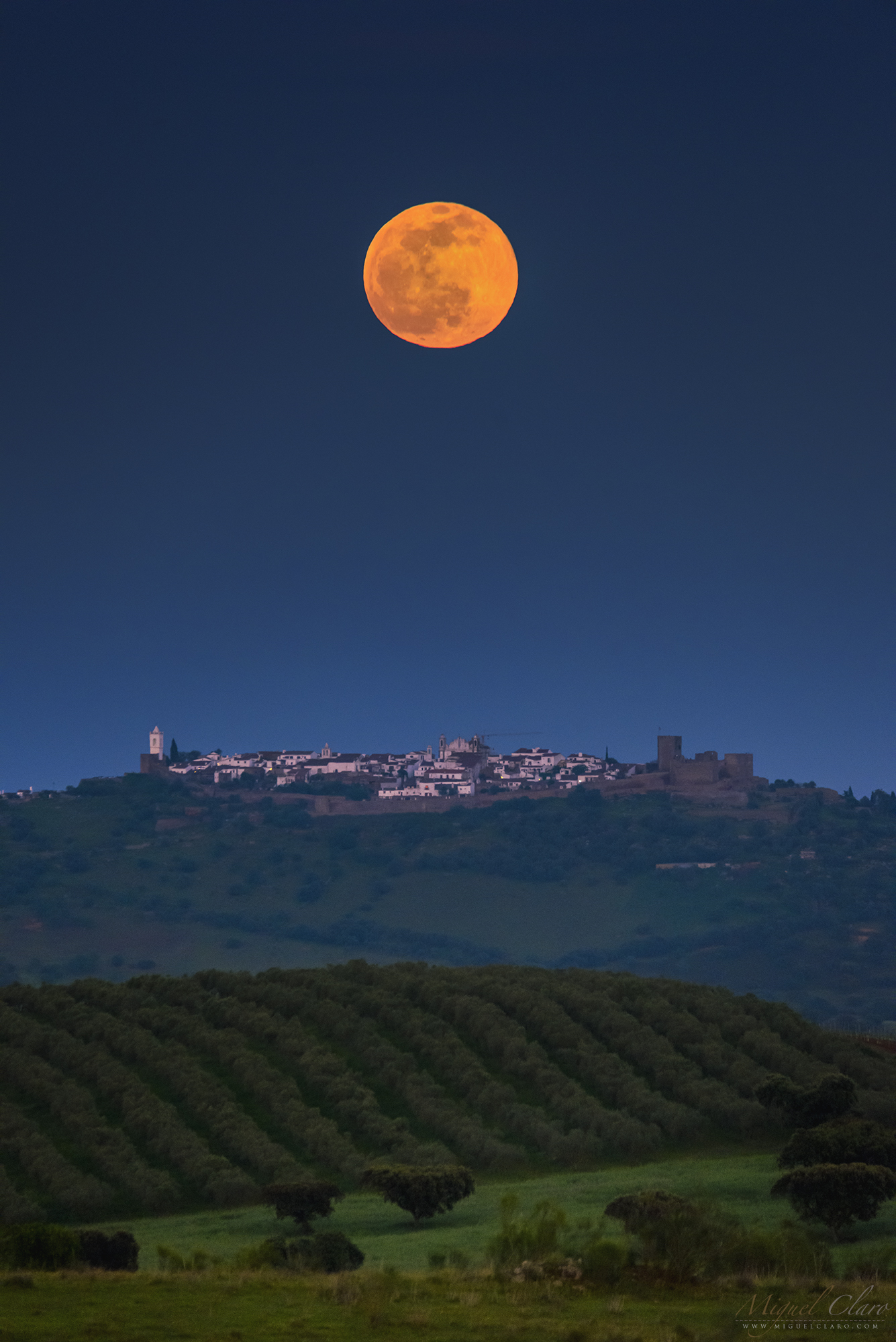
BUY THIS PRINT | COMPRAR ESTA IMPRESSÃO
Buy a Fine Art Print or Wall Decor of this Image – Make your order Now!
You can choose the best style of print do you preffer to decorate in a fashion way your walls. Metal Prints with durable and vivid colors, Acrylic, Canvas or the highest quality Gallery Print – a 6 colour UV direct printing on acrylic glass (2mm) including light colours and reinforced by an aluminium dibond plate (3mm). Those type of Prints can highlight the final work in an artistic way, showing the photograph as a piece of art. I work with two high quality specialized Labs in US and in Europe, using Kodak Professional Endura Premier Metallic papers and Fujifilm Crystal Archive DP II Professional. You can select the image above or freely navigate to more than 800 photographs available in my gallery – each one with their own story and magic – and choose the photograph you would love to have in your home or office.
How to Order – Simple and easy, just “copy and paste” the link of this page or the image you choosed and fill it in the form below, with the size you want and any detail you wish to include on the message, like your country, name and postal address. Free Shipping included to all prints (except frames). For US and Europe the delivery is 4-8 working days, while to Portugal and Spain is normally 2-6 working days. After submitting the order through the form, I will contact you for the payment method (Paypal available or bank transfer) and with other questions related to your print(s) or requests. Once payment is confirmed, your order is shipped within 24h. In case you wish, I can send you separtely with no additional cost, a postcard autographed and numbered of the same image you have just bought, as a seal and proof of art work authenticity from the author. Let me know what is your wish.
Cold Full Moon Rising Behind a Lonely Tree – Photo and Time Lapse

The still image shows a sequence of the full moon rising behind a wonderful lonely tree over a hill in Dark Sky® Alqueva region. Last December full moon, was also known as the cold moon, although, in some places like Alqueva, Portugal, even in December the weather can be provide nice and confortable temperatures. A time lapse footage of this same scene can be seen below. To watch with sound on.
PT: A imagem estática revela uma sequência da lua cheia surgindo atrás de uma árvore bela e solitária sobre uma colina na região de Dark Sky® Alqueva. A lua cheia de Dezembro, é também conhecida como a “lua fria”, embora em alguns locais como o Alqueva, Portugal, mesmo em Dezembro o tempo permita desfrutar de uma agradável e confortável temperatura. Em baixo é possível ver uma sequência vídeo time lapse. Para assistir com som ligado.
BUY THIS PRINT | COMPRAR ESTA IMPRESSÃO
Buy a Fine Art Print or Wall Decor of this Image – Make your order Now!
You can choose the best style of print do you preffer to decorate in a fashion way your walls. Metal Prints with durable and vivid colors, Acrylic, Canvas or the highest quality Gallery Print – a 6 colour UV direct printing on acrylic glass (2mm) including light colours and reinforced by an aluminium dibond plate (3mm). Those type of Prints can highlight the final work in an artistic way, showing the photograph as a piece of art. I work with two high quality specialized Labs in US and in Europe, using Kodak Professional Endura Premier Metallic papers and Fujifilm Crystal Archive DP II Professional. You can select the image above or freely navigate to more than 800 photographs available in my gallery – each one with their own story and magic – and choose the photograph you would love to have in your home or office.
How to Order – Simple and easy, just “copy and paste” the link of this page or the image you choosed and fill it in the form below, with the size you want and any detail you wish to include on the message, like your country, name and postal address. Free Shipping included to all prints (except frames). For US and Europe the delivery is 4-8 working days, while to Portugal and Spain is normally 2-6 working days. After submitting the order through the form, I will contact you for the payment method (Paypal available or bank transfer) and with other questions related to your print(s) or requests. Once payment is confirmed, your order is shipped within 24h. In case you wish, I can send you separtely with no additional cost, a postcard autographed and numbered of the same image you have just bought, as a seal and proof of art work authenticity from the author. Let me know what is your wish.
A lovely Moonrise in the Winter Sky above Lagoa do Fogo in Azores

Probably one of the most beautiful moonrises I have witness in many many years. Captured literally in middle of Atlantic Ocean, in the island of São Miguel, Azores, Portugal, the image reveals a panorama of single images taken around midnight from Lagoa do Fogo (Lake of Fire).The blue lake is located at 575 meters above the sea level – it is about 2 km long and 1 km wide – filling the ground of an extinct crater, whose caldera was formed during an eruption in 1563. In the background, a winter sky shows the bright light of the moon while rising between the mountains and against Auriga and Taurus constellation. Pleiades, is the blueish star cluster visible at center right. Near the left edge, stars from Big Dipper (Ursa Major) are very well visible above a layer of white clouds
PT: Provavelmente um dos mais belos nasceres da lua que já testemunhei em muitos anos. Captada literalmente em pleno Oceano Atlântico, na ilha de São Miguel, Açores, Portugal, a imagem revela um panorama de disparos únicas, feitos por volta da meia-noite a partir da Lagoa do Fogo. Esta lagoa azul está localizada a 575 metros acima do nível do mar – tem cerca de 2 km de comprimento e 1 km de largura – enchendo o solo de uma cratera extinta, cuja caldeira foi formada durante uma erupção em 1563. Em pano de fundo, um céu de inverno mostra a luz brilhante da lua enquanto esta se ergue por entre as montanhas e contra a constelação de Auriga e Taurus. As Pleiades são o aglomerado de estrelas azulado – por serem ainda jovens e quentes – visível no centro à direita. Perto do extremo esquerdo da imagem, as estrelas da Ursa Maior (Ursa Major) são bem visíveis acima de uma camada de nuvens brancas.
BUY THIS PRINT | COMPRAR ESTA IMPRESSÃO
Buy a Fine Art Print or Wall Decor of this Image – Make your order Now!
You can choose the best style of print do you preffer to decorate in a fashion way your walls. Metal Prints with durable and vivid colors, Acrylic, Canvas or the highest quality Gallery Print – a 6 colour UV direct printing on acrylic glass (2mm) including light colours and reinforced by an aluminium dibond plate (3mm). Those type of Prints can highlight the final work in an artistic way, showing the photograph as a piece of art. I work with two high quality specialized Labs in US and in Europe, using Kodak Professional Endura Premier Metallic papers and Fujifilm Crystal Archive DP II Professional. You can select the image above or freely navigate to more than 800 photographs available in my gallery – each one with their own story and magic – and choose the photograph you would love to have in your home or office.
How to Order – Simple and easy, just “copy and paste” the link of this page or the image you choosed and fill it in the form below, with the size you want and any detail you wish to include on the message, like your country, name and postal address. Free Shipping included to all prints (except frames). For US and Europe the delivery is 4-8 working days, while to Portugal and Spain is normally 2-6 working days. After submitting the order through the form, I will contact you for the payment method (Paypal available or bank transfer) and with other questions related to your print(s) or requests. Once payment is confirmed, your order is shipped within 24h. In case you wish, I can send you separtely with no additional cost, a postcard autographed and numbered of the same image you have just bought, as a seal and proof of art work authenticity from the author. Let me know what is your wish.
A Delightfull Moment under the Moonlilght with Jupiter

Enjoying a moonlight scene while rising above Atlantic Ocean, on a quiet night in a beach from Punta Cana, Dominican Republic.Only the sound of waves and the light of the moon with its “casual neighbor” Jupiter seen at the left side, could reach our senses in this peaceful place. But the best, was experiencing it in the company of my soulmate! What else do we need? And how about you dear reader, did you already know which special person would you choose to share a delightful moment like this..?
PT: Desfrutando de um cenário ao luar enquanto a Lua quase cheia se elevava acima do Oceano Atlântico, numa noite bem tranquila numa praia de Punta Cana, na República Dominicana. Apenas o som das ondas e a luz da lua com o seu “vizinho casual” Júpiter – à esquerda -poderia tocar os nossos sentidos envoltos na magia deste lugar pacífico. Mas o melhor, foi vivenciar esta experiência na companhia da minha alma gémea! E o leitor, já escolheu a pessoa especial com quem partilharia um momento delicioso como este…?
BUY THIS PRINT | COMPRAR ESTA IMPRESSÃO
Buy a Fine Art Print or Wall Decor of this Image – Make your order Now!
You can choose the best style of print do you preffer to decorate in a fashion way your walls. Metal Prints with durable and vivid colors, Acrylic, Canvas or the highest quality Gallery Print – a 6 colour UV direct printing on acrylic glass (2mm) including light colours and reinforced by an aluminium dibond plate (3mm). Those type of Prints can highlight the final work in an artistic way, showing the photograph as a piece of art. I work with two high quality specialized Labs in US and in Europe, using Kodak Professional Endura Premier Metallic papers and Fujifilm Crystal Archive DP II Professional. You can select the image above or freely navigate to more than 800 photographs available in my gallery – each one with their own story and magic – and choose the photograph you would love to have in your home or office.
How to Order – Simple and easy, just “copy and paste” the link of this page or the image you choosed and fill it in the form below, with the size you want and any detail you wish to include on the message, like your country, name and postal address. Free Shipping included to all prints (except frames). For US and Europe the delivery is 4-8 working days, while to Portugal and Spain is normally 2-6 working days. After submitting the order through the form, I will contact you for the payment method (Paypal available or bank transfer) and with other questions related to your print(s) or requests. Once payment is confirmed, your order is shipped within 24h. In case you wish, I can send you separtely with no additional cost, a postcard autographed and numbered of the same image you have just bought, as a seal and proof of art work authenticity from the author. Let me know what is your wish.
Moonrise Crossing an Inversion Layer Showing the Rare Lunar Red Flash

The image and video time lapse shows the full moonrise of last June 24, 2021, vividly orange in color above a hill made by rocky wastes from an extraction of marble, in Borba. In the foreground, blurred greenish hues belongs to a vineyard which is out of focus in the frame for being not faraway from my 600mm telephoto lens. Above the horizon, a sequence of shots shows the moon rising while seems to immerse into a layer of strong temperature inversion, where warm air is above colder air, creating the right conditions to show a rare phenomenon known as lunar “red flash”. On the second moon of the still photo sequence, is visible a red flash below the disc, appearing detach from the main body itself. Expert Les Cowley explains on his Atmospheric Optics website, “when crossing the layers, light rays bend so that they are reflected up and down. This phenomenon is the result of mirages and color separation. We usually see a green flash when the Sun or Moon dips down into the inversion.The near horizon moon has an upper green rim (green because much blue light is scattered away) and a lower red rim. A mirage is needed to magnify these into a green or red flash. The “Etruscan Vase” or “Omega mirage” is formed by refraction across the temperature/density gradients of warm air beneath cooler.” .
PT: A imagem e vídeo time lapse, revelam o nascer da lua cheia no passado dia 24 de Junho de 2021, com uma cor vívida laranja, acima de uma colina formada por resíduos rochosos de uma extração de mármore, em Borba. No primeiro plano, os tons esverdeados pertencem a uma vinha que está desfocado no enquadramento por não estar muito longe da minha teleobjetiva de 600 mm. Acima do horizonte, uma sequência de fotos mostra a lua nascendo enquanto parece imergir de uma camada com uma forte inversão de temperatura, onde o ar quente está acima do ar mais frio, criando as condições certas para mostrar um fenómeno raro, conhecido como “flash vermelho” lunar. Na segunda lua da sequência fotográfica estática, é visível um pequeno “flash” vermelho alongado logo abaixo do limbo, que se parece desprender do próprio disco lunar. O especialista britânico Les Cowley explica no seu site Atmospheric Optics, “ao cruzar as camadas, os raios de luz curvam-se de modo que são refletidos para cima e para baixo. Este fenómeno é o resultado de miragens e separação de cores. Normalmente vemos um flash verde quando o Sol ou a Lua mergulha na inversão. A lua próxima do horizonte, tem uma borda verde superior (verde porque muita da luz azul é espalhada) e uma borda vermelha inferior. Uma miragem é no entanto necessária para ampliar actuante como uma lente gigante, tornando assim visível o flash verde ou vermelho. O “Etruscan Vase” ou “Miragem Omega” é formado pela refração através dos gradientes de temperatura – densidade do ar quente abaixo do mais frio. “.
BUY THIS PRINT | COMPRAR ESTA IMPRESSÃO
Buy a Fine Art Print or Wall Decor of this Image – Make your order Now!
You can choose the best style of print do you preffer to decorate in a fashion way your walls. Metal Prints with durable and vivid colors, Acrylic, Canvas or the highest quality Gallery Print – a 6 colour UV direct printing on acrylic glass (2mm) including light colours and reinforced by an aluminium dibond plate (3mm). Those type of Prints can highlight the final work in an artistic way, showing the photograph as a piece of art. I work with two high quality specialized Labs in US and in Europe, using Kodak Professional Endura Premier Metallic papers and Fujifilm Crystal Archive DP II Professional. You can select the image above or freely navigate to more than 800 photographs available in my gallery – each one with their own story and magic – and choose the photograph you would love to have in your home or office.
How to Order – Simple and easy, just “copy and paste” the link of this page or the image you choosed and fill it in the form below, with the size you want and any detail you wish to include on the message, like your country, name and postal address. Free Shipping included to all prints (except frames). For US and Europe the delivery is 4-8 working days, while to Portugal and Spain is normally 2-6 working days. After submitting the order through the form, I will contact you for the payment method (Paypal available or bank transfer) and with other questions related to your print(s) or requests. Once payment is confirmed, your order is shipped within 24h. In case you wish, I can send you separtely with no additional cost, a postcard autographed and numbered of the same image you have just bought, as a seal and proof of art work authenticity from the author. Let me know what is your wish.
Super Flower Full Moon of May in a Golden Moonrise

People in Australia, parts of the western US, western South America, or in South-East Asia, will enjoy tonight a Super Flower Full Moon totally eclipsed and turn a shade of red for about 14 minutes during this total lunar eclipse. Unfortunatly, we located in Europe will not be able this time to appreciate a TLE, although, the event of moonrise will be spectaular anyway, as tonight will be Super a Fullmoon. Supermoons happen when a full moon approximately coincides with the moon’s perigee, or a point in its orbit at which it is closest to Earth. The single image captured yesterday night, shows a golden moonrise above a hill full of trees in Telheiro, at Dark Sky® Alqueva, Portugal. The Full Moon of May is known as the Flower Moon to signify the flowers that bloom during this month.
PT: Na Austrália, a Oeste dos Estados Unidos e da América do Sul ou Sudeste da Ásia, irão poder apreciar esta noite, 26 de Maio de 2021, uma Super Lua Cheia, também designada de “Super Flower Moon”, totalmente eclipsada, que ficará envolta num tom avermelhado por cerca de 14 minutos durante este Eclipse Lunar Total. Infelizmente, quem estiver na Europa não poderá apreciar desta vez o Eclipse. No entanto, o nascimento da Lua será igualmente espetacular, já que hoje será uma Super Lua Cheia. As Superluas acontecem quando a lua cheia coincide aproximadamente com o perigeu da lua, ou o ponto orbital mais próximo da Terra. Esta imagem de um disparo único, captada ontem à noite, dia 25 de Maio, mostra um nascer de uma lua dourada sobre uma colina arborizada no Telheiro, nos céus do Dark Sky® Alqueva, Portugal. A Lua Cheia de Maio é conhecida como a Lua da Flor por estar associada à grande diversidade de flores que desabrocham durante esta época mês.
BUY THIS PRINT | COMPRAR ESTA IMPRESSÃO
Buy a Fine Art Print or Wall Decor of this Image – Make your order Now!
You can choose the best style of print do you preffer to decorate in a fashion way your walls. Metal Prints with durable and vivid colors, Acrylic, Canvas or the highest quality Gallery Print – a 6 colour UV direct printing on acrylic glass (2mm) including light colours and reinforced by an aluminium dibond plate (3mm). Those type of Prints can highlight the final work in an artistic way, showing the photograph as a piece of art. I work with two high quality specialized Labs in US and in Europe, using Kodak Professional Endura Premier Metallic papers and Fujifilm Crystal Archive DP II Professional. You can select the image above or freely navigate to more than 800 photographs available in my gallery – each one with their own story and magic – and choose the photograph you would love to have in your home or office.
How to Order – Simple and easy, just “copy and paste” the link of this page or the image you choosed and fill it in the form below, with the size you want and any detail you wish to include on the message, like your country, name and postal address. Free Shipping included to all prints (except frames). For US and Europe the delivery is 4-8 working days, while to Portugal and Spain is normally 2-6 working days. After submitting the order through the form, I will contact you for the payment method (Paypal available or bank transfer) and with other questions related to your print(s) or requests. Once payment is confirmed, your order is shipped within 24h. In case you wish, I can send you separtely with no additional cost, a postcard autographed and numbered of the same image you have just bought, as a seal and proof of art work authenticity from the author. Let me know what is your wish.
Planet Alqueva Under the Moonlight in a VR 360º Scene

Captured in Dark Sky® Alqueva Lake, a Little Planet and 360º Virtual Reality scene, shows the fields surrounding the lake spread by olive trees, holm oak and cork trees, with its long shadows cast by the lower angle of moonlight, while in the opposite direction of the sky, is faintly visible the arch of Milky Way rising above the Eastern horizon, yet immersed in the blueish scattered light from the moon, while interacting with our atmosphere. Summer Triangle is totally visible with blueish Vega near the top, while Ursa Major (Big Dipper) dominates the Zenith of the full dome 360º VR view. Below is available a Virtual Reality 360º scene, which you can experience in full resolution using your desktop, or smartphone with gyroscope. A great “in loco” experience can be achieved if you wear a VR glasses.
BUY THIS PRINT | COMPRAR ESTA IMPRESSÃO
Buy a Fine Art Print or Wall Decor of this Image – Make your order Now!
You can choose the best style of print do you preffer to decorate in a fashion way your walls. Metal Prints with durable and vivid colors, Acrylic, Canvas or the highest quality Gallery Print – a 6 colour UV direct printing on acrylic glass (2mm) including light colours and reinforced by an aluminium dibond plate (3mm). Those type of Prints can highlight the final work in an artistic way, showing the photograph as a piece of art. I work with two high quality specialized Labs in US and in Europe, using Kodak Professional Endura Premier Metallic papers and Fujifilm Crystal Archive DP II Professional. You can select the image above or freely navigate to more than 800 photographs available in my gallery – each one with their own story and magic – and choose the photograph you would love to have in your home or office.
How to Order – Simple and easy, just “copy and paste” the link of this page or the image you choosed and fill it in the form below, with the size you want and any detail you wish to include on the message, like your country, name and postal address. Free Shipping included to all prints (except frames). For US and Europe the delivery is 4-8 working days, while to Portugal and Spain is normally 2-6 working days. After submitting the order through the form, I will contact you for the payment method (Paypal available or bank transfer) and with other questions related to your print(s) or requests. Once payment is confirmed, your order is shipped within 24h. In case you wish, I can send you separtely with no additional cost, a postcard autographed and numbered of the same image you have just bought, as a seal and proof of art work authenticity from the author. Let me know what is your wish.
ISS Crossing the Entire Sky and the Moon in a Fish-eye Full Dome Scene

The image shows a fish-eye full dome sequence of the ISS – International Space Station – crossing the entire sky while transiting in front of the crescent moon over Borba region, in Alentejo, Portugal, on 18th January 2021 at UT 19h14m41s. In the background, a moonlight starry sky shows the path of the brightest winter constellations while in the top edge is visible the faint dragged light of Milky Way. In the foreground, shines my septup with telescope and cameras pointing high, while I was enjoying and registering in a close-up view, this rare transit of the ISS against the moon. Below is available a close-up sequence and a time lapse video captured during this event. Click on each image below to entering in each dedicated page.
PT: A imagem revela uma sequência captada com uma lente fish-eye circular (180º) da ISS – Estação Espacial Internacional – cruzando ao longo do céu enquanto transitou em frente à lua crescente sobre a região de Borba, no Alentejo, Portugal, a 18 de janeiro de 2021 pelas 19h14m41s UT. Em pano de fundo, um céu estrelado ao luar revela o caminho das constelações de inverno mais brilhantes, enquanto no topo é visível a luz fraca e arrastada da Via Láctea. Em primeiro plano, reluz o meu setup composto por um telescópio e uma câmara apontada para o alto, enquanto desfrutava e registava em close-up este raro trânsito da Estação Espacial em frente à lua. Em baixo é possível aceder a uma imagem close-up e a uma sequência video time lapse captada durante este evento. Click em cada imagem para aceder à respectiva página.


BUY THIS PRINT | COMPRAR ESTA IMPRESSÃO
Buy a Fine Art Print or Wall Decor of this Image – Make your order Now!
You can choose the best style of print do you preffer to decorate in a fashion way your walls. Metal Prints with durable and vivid colors, Acrylic, Canvas or the highest quality Gallery Print – a 6 colour UV direct printing on acrylic glass (2mm) including light colours and reinforced by an aluminium dibond plate (3mm). Those type of Prints can highlight the final work in an artistic way, showing the photograph as a piece of art. I work with two high quality specialized Labs in US and in Europe, using Kodak Professional Endura Premier Metallic papers and Fujifilm Crystal Archive DP II Professional. You can select the image above or freely navigate to more than 800 photographs available in my gallery – each one with their own story and magic – and choose the photograph you would love to have in your home or office.
How to Order – Simple and easy, just “copy and paste” the link of this page or the image you choosed and fill it in the form below, with the size you want and any detail you wish to include on the message, like your country, name and postal address. Free Shipping included to all prints (except frames). For US and Europe the delivery is 4-8 working days, while to Portugal and Spain is normally 2-6 working days. After submitting the order through the form, I will contact you for the payment method (Paypal available or bank transfer) and with other questions related to your print(s) or requests. Once payment is confirmed, your order is shipped within 24h. In case you wish, I can send you separtely with no additional cost, a postcard autographed and numbered of the same image you have just bought, as a seal and proof of art work authenticity from the author. Let me know what is your wish.
Astrophotography Workshop Under the Moonlight in Dark Sky® Alqueva Mértola

Captured during one of my workshops in Mértola, @darkskyalqueva, this short time lapse sequence shows the Milky Way rising while the moon is yet illuminating the background sky before setting in the opposite direction. To know more about my workshops, click here.
PT: Captada durante um dos meus workshops no território do Dark Sky® Alqueva, em Mértola, esta curta sequência de lapso de tempo mostra a Via Láctea nascendo enquanto a lua ainda está iluminando o céu de fundo antes de se pôr na direção oposta do céu. Para saber mais acerca do meus workshops, clique aqui.
BUY THIS PRINT | COMPRAR ESTA IMPRESSÃO
Buy a Fine Art Print or Wall Decor of this Image – Make your order Now!
You can choose the best style of print do you preffer to decorate in a fashion way your walls. Metal Prints with durable and vivid colors, Acrylic, Canvas or the highest quality Gallery Print – a 6 colour UV direct printing on acrylic glass (2mm) including light colours and reinforced by an aluminium dibond plate (3mm). Those type of Prints can highlight the final work in an artistic way, showing the photograph as a piece of art. I work with two high quality specialized Labs in US and in Europe, using Kodak Professional Endura Premier Metallic papers and Fujifilm Crystal Archive DP II Professional. You can select the image above or freely navigate to more than 800 photographs available in my gallery – each one with their own story and magic – and choose the photograph you would love to have in your home or office.
How to Order – Simple and easy, just “copy and paste” the link of this page or the image you choosed and fill it in the form below, with the size you want and any detail you wish to include on the message, like your country, name and postal address. Free Shipping included to all prints (except frames). For US and Europe the delivery is 4-8 working days, while to Portugal and Spain is normally 2-6 working days. After submitting the order through the form, I will contact you for the payment method (Paypal available or bank transfer) and with other questions related to your print(s) or requests. Once payment is confirmed, your order is shipped within 24h. In case you wish, I can send you separtely with no additional cost, a postcard autographed and numbered of the same image you have just bought, as a seal and proof of art work authenticity from the author. Let me know what is your wish.
A Moon Glory and a Brocken Spectre Shinning above Dark Sky® Vale do Tua

Featured as OPOD – Optics Picture of the Day, the image reveals a starry landscape scene from the viewpoint of Ujo and overlooking to the extensive Tua valley and the current reservoir on a moonlit foggy night, while the Waning Moon was laying down behind the mountains, creating a ringed Moon Glory and a Brocken Spectre shadow, as seen on lower center left of this wide panoramic scene. Resembling an iconic saint’s halo, a Glory happens in rare occasions, when the moonlight is interacting with the tiny water droplets that compose mist or clouds. Consisting in one or more concentric rings successively dimming, in which each is red on the outside and bluish towards the centre, it is centered on the antilunar point, coinciding with the shadow of the observer’s head. Since this point is by definition diametrically opposed to the moon’s position in the night sky, it always lies below the observer’s horizon when the moon is up. When viewed from a mountain, glories are often seen in association with a Brocken spectre, also called Mountain spectre, the apparently enormously magnified shadow, cast when the moon or sun is low, on clouds below the mountain on which the viewer is standing. The name derives from the Brocken, the tallest peak of the Harz mountain range in Germany. Captured from Dark Sky® Vale do Tua, recently certified as an International Starlight Tourist Destination located in the northern part of Portugal.
BUY THIS PRINT | COMPRAR ESTA IMPRESSÃO
Buy a Fine Art Print or Wall Decor of this Image – Make your order Now!
You can choose the best style of print do you preffer to decorate in a fashion way your walls. Metal Prints with durable and vivid colors, Acrylic, Canvas or the highest quality Gallery Print – a 6 colour UV direct printing on acrylic glass (2mm) including light colours and reinforced by an aluminium dibond plate (3mm). Those type of Prints can highlight the final work in an artistic way, showing the photograph as a piece of art. I work with two high quality specialized Labs in US and in Europe, using Kodak Professional Endura Premier Metallic papers and Fujifilm Crystal Archive DP II Professional. You can select the image above or freely navigate to more than 800 photographs available in my gallery – each one with their own story and magic – and choose the photograph you would love to have in your home or office.
How to Order – Simple and easy, just “copy and paste” the link of this page or the image you choosed and fill it in the form below, with the size you want and any detail you wish to include on the message, like your country, name and postal address. Free Shipping included to all prints (except frames). For US and Europe the delivery is 4-8 working days, while to Portugal and Spain is normally 2-6 working days. After submitting the order through the form, I will contact you for the payment method (Paypal available or bank transfer) and with other questions related to your print(s) or requests. Once payment is confirmed, your order is shipped within 24h. In case you wish, I can send you separtely with no additional cost, a postcard autographed and numbered of the same image you have just bought, as a seal and proof of art work authenticity from the author. Let me know what is your wish.
Disk Sequence of a Reddish Moonrise Against Earth Shadow and Belt of Venus

A countryside scene captured from Juromenha inside Dark Sky® Alqueva territory and facing to Spain, shows a disk sequence of a reddish moonrise over the hills of Spanish horizon on 5 June 2020. Even being partially eclipsed due to a Penumbral lunar eclipse – happening when the Moon passes through Earth’s faint outer shadow – during the nautical twilight is difficult to notice this faint shadow on the moon´s disk, although, a second photo shows a related phenomenon visible almost every day known as the Earth’s shadow. This shadow is visible in the opposite half of the sky to the sunset or sunrise, and is seen right above the horizon as a dark blue band. Immediately above, where the evening air is still lit, glows a pink band called the anti-twilight arch, also known as “Belt of Venus”, and is caused by backscattering of refracted sunlight due to fine dust particles high in the atmosphere..
PT: Um cenário rural captado a partir de Juromenha dentro do território Dark Sky® Alqueva e voltado para Espanha, revela uma sequência do disco lunar avermelhado sobre as colinas do horizonte espanhol em 5 de junho de 2020. Já nascendo parcialmente eclipsada devido a um eclipse lunar Penumbral – que ocorre quando a Lua atravessa a fraca sombra externa da Terra – durante o crepúsculo náutico é difícil perceber essa sombra fraca projectada no disco da lua, no entanto, um fenémeno relacionado pode ser visível quase todos os dias. Conhecido como “Earth Shadow” ou sombra da Terra. Essa sombra é visível na metade do céu oposta ao pôr do sol, ou ao nascer do sol. É visível logo acima do horizonte como uma faixa azul escura. Imediatamente acima, onde o ar da tarde ainda está iluminado, brilha uma faixa rosa chamada arco anti-crepuscular, também conhecido como “Cinturão de Vénus”, e é causada pelo retroespalhamento da luz solar refractada devido a finas partículas de poeira na atmosfera!
BUY THIS PRINT | COMPRAR ESTA IMPRESSÃO
Buy a Fine Art Print or Wall Decor of this Image – Make your order Now!
You can choose the best style of print do you preffer to decorate in a fashion way your walls. Metal Prints with durable and vivid colors, Acrylic, Canvas or the highest quality Gallery Print – a 6 colour UV direct printing on acrylic glass (2mm) including light colours and reinforced by an aluminium dibond plate (3mm). Those type of Prints can highlight the final work in an artistic way, showing the photograph as a piece of art. I work with two high quality specialized Labs in US and in Europe, using Kodak Professional Endura Premier Metallic papers and Fujifilm Crystal Archive DP II Professional. You can select the image above or freely navigate to more than 800 photographs available in my gallery – each one with their own story and magic – and choose the photograph you would love to have in your home or office.
How to Order – Simple and easy, just “copy and paste” the link of this page or the image you choosed and fill it in the form below, with the size you want and any detail you wish to include on the message, like your country, name and postal address. Free Shipping included to all prints (except frames). For US and Europe the delivery is 4-8 working days, while to Portugal and Spain is normally 2-6 working days. After submitting the order through the form, I will contact you for the payment method (Paypal available or bank transfer) and with other questions related to your print(s) or requests. Once payment is confirmed, your order is shipped within 24h. In case you wish, I can send you separtely with no additional cost, a postcard autographed and numbered of the same image you have just bought, as a seal and proof of art work authenticity from the author. Let me know what is your wish.
Reddish “Eclipsed” Full Moon Rising above Spain

A countryside scene captured from Juromenha inside Dark Sky® Alqueva territory and facing to Spain, shows a reddish moonrise over the hills of Spanish horizon on 5 June 2020. Even being partially eclipsed due to a Penumbral lunar eclipse – happening when the Moon passes through Earth’s faint outer shadow – during the nautical twilight is difficult to notice this faint shadow on the moon´s disk, although, a second photo shows a related phenomenon visible almost every day known as the Earth’s shadow. This shadow is visible in the opposite half of the sky to the sunset or sunrise, and is seen right above the horizon as a dark blue band. Immediately above, where the evening air is still lit, glows a pink band called the anti-twilight arch, also known as “Belt of Venus”, and is caused by backscattering of refracted sunlight due to fine dust particles high in the atmosphere..
PT: Um cenário rural captado a partir de Juromenha dentro do território Dark Sky® Alqueva e voltado para Espanha, revela um nascer de uma lua cheia avermelhado sobre as colinas do horizonte espanhol em 5 de junho de 2020. Já nascendo parcialmente eclipsada devido a um eclipse lunar Penumbral – que ocorre quando a Lua atravessa a fraca sombra externa da Terra – durante o crepúsculo náutico é difícil perceber essa sombra fraca projectada no disco da lua, no entanto, um fenémeno relacionado pode ser visível quase todos os dias. Conhecido como “Earth Shadow” ou sombra da Terra. Essa sombra é visível na metade do céu oposta ao pôr do sol, ou ao nascer do sol. É visível logo acima do horizonte como uma faixa azul escura. Imediatamente acima, onde o ar da tarde ainda está iluminado, brilha uma faixa rosa chamada arco anti-crepuscular, também conhecido como “Cinturão de Vénus”, e é causada pelo retroespalhamento da luz solar refractada devido a finas partículas de poeira na atmosfera!
BUY THIS PRINT | COMPRAR ESTA IMPRESSÃO
Buy a Fine Art Print or Wall Decor of this Image – Make your order Now!
You can choose the best style of print do you preffer to decorate in a fashion way your walls. Metal Prints with durable and vivid colors, Acrylic, Canvas or the highest quality Gallery Print – a 6 colour UV direct printing on acrylic glass (2mm) including light colours and reinforced by an aluminium dibond plate (3mm). Those type of Prints can highlight the final work in an artistic way, showing the photograph as a piece of art. I work with two high quality specialized Labs in US and in Europe, using Kodak Professional Endura Premier Metallic papers and Fujifilm Crystal Archive DP II Professional. You can select the image above or freely navigate to more than 800 photographs available in my gallery – each one with their own story and magic – and choose the photograph you would love to have in your home or office.
How to Order – Simple and easy, just “copy and paste” the link of this page or the image you choosed and fill it in the form below, with the size you want and any detail you wish to include on the message, like your country, name and postal address. Free Shipping included to all prints (except frames). For US and Europe the delivery is 4-8 working days, while to Portugal and Spain is normally 2-6 working days. After submitting the order through the form, I will contact you for the payment method (Paypal available or bank transfer) and with other questions related to your print(s) or requests. Once payment is confirmed, your order is shipped within 24h. In case you wish, I can send you separtely with no additional cost, a postcard autographed and numbered of the same image you have just bought, as a seal and proof of art work authenticity from the author. Let me know what is your wish.
Little Owls Breeding Against a Golden Supermoon

Captured during the full moon of March – called the Worm Moon – was indeed the first supermoon of the year 2020. Despite this interesting moment, which normally happens when the full moon coincides with its perigee, the single image reveals an out of focus moonrise in the background sky, while in the foreground two little Owls are visible in the branches of a naked tree during the twilight. The little Owl (Athene noctua) is a small nocturnal bird which inhabiting the temperate and warmer regions of Europe, being one of the nocturnal bird species more common to watch in Mértola, Dark Sky® Alqueva territory, Portugal. This Owls becomes more vocal at night as the breeding season approaches in late spring, and a pair may call in duet. During an assignment to photograph nocturnal birds in this territory and accompanied by a specialist guide Helder Cardoso (from Birds & Nature Tours), I had the unique and mesmerising chance to capture the real moment when they start to mate with the male on top of the female, while the wings were in motion and against a golden moonrise. In some other shots, we also can enjoy one little Owl flying while the other was standing in the top of the tree. The little Owl is also associated with the Greek goddess Athena and the Roman goddess Minerva, representing wisdom and knowledge. A little Owl with an olive branch appears on a Greek tetradrachm coin from 500 BC. I also did a short real time vídeo (not a timelapse) with the moon slowing moving in the background sky, while the silhouette of two Owls are visible in the branches.

PT: Captada durante a lua cheia de março – apelidada de Worm Moon – foi a primeira superlua do ano 2020. Apesar desse momento interessante, que normalmente acontece quando a lua cheia coincide com o perigeu, a imagem resultante de um disparo único, revela o nascer de uma lua desfocada em pano de fundo, enquanto as atenções recaem no primeiro plano onde dois mochos-galegos são visíveis nos galhos de uma árvore despida, durante o crepúsculo náutico. O mocho-galego (Athene noctua) é a ave de rapina nocturna mais fácil de observar e que habita as regiões temperadas e quentes da Europa, sendo uma das espécies de aves noturnas mais comuns em Mértola, no território do Dark Sky® Alqueva, Portugal. Este pequenos mochos tornam-se mais vocais à noite, à medida que a estação de reprodução se aproxima, no final da primavera, e um par pode vocalizar em dueto. Em missão fotográfica num trabalho para captar as aves noturnas mais comuns deste território e acompanhado pelo guia especializado Helder Cardoso (Birds & Nature Tours), tive a chance única e fascinante de registar o momento real em que eles começaram a acasalar com o macho por cima da fêmea, enquanto as asas estavam em movimento e contra um nascer de uma Lua Cheia dourada. Ficaram ainda registados outros momentos distintos desta noite, com um mocho-galego em pleno voo enquanto a sua cara metade esperava pacientemente no topo da árvore. O mocho também está associada à deusa grega Atena e à deusa romana Minerva, representando sabedoria e conhecimento. Uma pequeno mocho com um ramo de oliveira está representado numa moeda grega de Tetradrachm (500 aC). Por fim, é ainda possível ver um pequeno vídeo em tempo real (não um timelapse) com a lua se movendo lentamente em pano de fundo, enquanto a silhueta de dois mochos-galegos é visível nos galhos de uma árvore.
Above is a short video and below a close-up view

A Moonlight Scene Shows Ursa Major above Alqueva Lake

A moonlight scene captured in Campinho village, near the lake Alqueva from Dark Sky® reserve, shows the brightest stars that are composing the well known asterism of Big Dipper or Ursa Major. Probably the easiest constellation recognisable in night time, are normally used as a starting point, from beginners to experienced stargazers, to help localize and identify the northern star, also known as Polaris.
BUY THIS PRINT | COMPRAR ESTA IMPRESSÃO
Buy a Fine Art Print or Wall Decor of this Image – Make your order Now!
You can choose the best style of print do you preffer to decorate in a fashion way your walls. Metal Prints with durable and vivid colors, Acrylic, Canvas or the highest quality Gallery Print – a 6 colour UV direct printing on acrylic glass (2mm) including light colours and reinforced by an aluminium dibond plate (3mm). Those type of Prints can highlight the final work in an artistic way, showing the photograph as a piece of art. I work with two high quality specialized Labs in US and in Europe, using Kodak Professional Endura Premier Metallic papers and Fujifilm Crystal Archive DP II Professional. You can select the image above or freely navigate to more than 800 photographs available in my gallery – each one with their own story and magic – and choose the photograph you would love to have in your home or office.
How to Order – Simple and easy, just “copy and paste” the link of this page or the image you choosed and fill it in the form below, with the size you want and any detail you wish to include on the message, like your country, name and postal address. Free Shipping included to all prints (except frames). For US and Europe the delivery is 4-8 working days, while to Portugal and Spain is normally 2-6 working days. After submitting the order through the form, I will contact you for the payment method (Paypal available or bank transfer) and with other questions related to your print(s) or requests. Once payment is confirmed, your order is shipped within 24h. In case you wish, I can send you separtely with no additional cost, a postcard autographed and numbered of the same image you have just bought, as a seal and proof of art work authenticity from the author. Let me know what is your wish.
Penumbral Lunar Eclipse and Anti-twilight Arch as Seen from Lisbon City

A cityscape view captured from the highest point of Lisbon, shows the first Full Moon of the year, rising above the capital of Portugal on 10th January, 2020, with Tagus River visible in the background. Even being partially eclipsed due to a Penumbral lunar eclipse – happening when the Moon passes through Earth’s faint outer shadow – during the nautical twilight is difficult to notice this faint shadow on the moon´s disk, although, a related phenomenon is visible almost every day known as the Earth’s shadow. This shadow is visible in the opposite half of the sky to the sunset or sunrise, and is seen right above the horizon as a dark blue band. Immediately above, where the evening air is still lit, glows a pink band called the anti-twilight arch, also known as “Belt of Venus”, and is caused by backscattering of refracted sunlight due to fine dust particles high in the atmosphere. While the first Eclipsed Full Moon of the year was rising above Lisbon, by coincidence, a flying seagull was luckily caught in the scene. The image also reveals a strong atmospheric turbulence happening, causing a clearly distortion on the “round” moon´s disc.
PT: Um cenário da paisagem urbana captado no ponto mais alto de Lisboa, revela a primeira Lua Cheia do ano elevando-se acima da capital, a 10 de janeiro de 2020, com o Rio Tejo visível em pano de fundo. Já nascendo parcialmente eclipsada devido a um eclipse lunar Penumbral – que ocorre quando a Lua atravessa a fraca sombra externa da Terra – durante o crepúsculo náutico é difícil perceber essa sombra fraca projectada no disco da lua, no entanto, um fenémeno relacionado pode ser visível quase todos os dias. Conhecido como “Earth Shadow” ou sombra da Terra. Essa sombra é visível na metade do céu oposta ao pôr do sol, ou ao nascer do sol. É visível logo acima do horizonte como uma faixa azul escura. Imediatamente acima, onde o ar da tarde ainda está iluminado, brilha uma faixa rosa chamada arco anti-crepuscular, também conhecido como “Cinturão de Vénus”, e é causada pelo retroespalhamento da luz solar refractada devido a finas partículas de poeira na atmosfera. Enquanto a primeira lua cheia eclipsada do ano se elevava acima de Lisboa, por coincidência, uma gaivota voou na direcção certa, alinhado-se em cena. A imagem revela ainda uma forte turbulência atmosférica, causando uma clara distorção no expectável disco “redondo” da lua.
The Path of a Winter Earthshine – Photo and Time Lapse

A still composition shows an Earthshine time lapse sequence with the path of a Crescent Moon captured at the end of nautical twilight, after an unusual – hot for the season – crystal clear day not so expected during the winter time, perhaps related with global warming and climate changes, when the Moon was setting behind a hill full of trees from the fluvial beach of Amieira, in Dark Sky® Alqueva territory, Portugal. The intensity of Earthshines could vary throughout the year, as they are connected with the Albedo of Earth, the incident light that is reflected to space by the surface of our planet and reaches the Moon. This impressive phenomenon known as Earthshine, was described and drawn for the first time, by the talented Leonardo Da Vinci about 500 years ago on his book Codex Leicester. Below is available a short time lapse footage of this sequence. At the end of the video, a cumulative trailed sequence shows the path of the moon moving in reverse mode.
PT: Uma composição estática revela uma sequência de lapso de tempo de um Earthshine lunar com o rasto de uma Lua Crescente visível no final do Crepúsculo Náutico, após um dia incomum – quente e cristalino para a estação do ano – pouco expectável durante o inverno, talvez relacionado com o aquecimento global e mudanças climáticas, quando a Lua se punha por detrás de uma colina cheia de árvores da praia fluvial de Amieira, no território do Dark Sky® Alqueva, Portugal. A intensidade dos Earthshines pode variar ao longo do ano, pois está relacionada com o Albedo da Terra, a luz incidente que é refletida para o espaço pela superfície do nosso planeta e chega assim à superfície da Lua. Este impressionante fenómeno conhecido como Earthshine, foi descrito e desenhado pela primeira vez pelo talentoso Leonardo Da Vinci há cerca de 500 anos atrás, no seu livro Codex Leicester. Em baixo está disponível um vídeo time lapse durante o pôr-da-lua. No final deste, uma sequência cumulativa revela o rasto da lua em modo reverso.
Winter Lunar Earthshine Aligned with Planet Saturn

The image reveals an Earthshine of a Crescent Moon captured at the end of nautical twilight, when the Moon was in conjuction with planet Saturn. Only separated by 3º, the planet is visible as a yellowish star on the right edge of the image, above a hill with trees from fluvial beach of Amieira, in Dark Sky® Alqueva territory, Portugal.
PT: A imagem revela um Earthshine Lunar na fase de Quarto Crescente, captado durante o Crepúsculo Náutico, quando a Lua se econtrava em conjunção com o planeta Saturno. Apenas separado por 3º, Saturno é a estrela amarelada visível no canto direito da imagem, acima da colina com árvores pertencente à praia fluvial da Amieira, região do Dark Sky® Alqueva, Portugal.
A Moonlight Scene Shows Venus and Saturn in Conjunction above a Mill in Evoramonte

The image feature a Mill located in Evoramonte village during a night scene under the moonlight. After the twilight, on December 11, 2019 two planets were visible in conjunction only sparated by 2º degrees apart. Venus is the brightest one above the Mill´s roof, and next to it, is visible “another star”, wich is actaully planet Saturn.
In Evoramonte was signed on 26th May of 1834, a Peace Treaty known as “Convention of Evoramonte” or “Concession of Evoramonte” which ended the only Portuguese civil war in almost 900 years of History. Due to this important historical heritage, Evoramonte is also the birthplace of the European Network of Places of Peace (www.placesofpeace.eu).

PT: A imagem mostra um moinho localizado na vila de Evoramonte durante um cenário noturno ao luar. Após o crepúsculo, em 11 de dezembro de 2019, dois planetas estavam allinhados numa conjunção que apenas os separava por 2º graus de distância. Vénus é a estrela mais brilhante acima do telhado do Moinho, e logo à sua direita, brilha “outra estrela” mais tímida, é na verdade o planeta Saturno.
Em Evoramonte foi assinado em 26 de maio de 1834, um Tratado de Paz conhecido como “Convenção de Evoramonte” ou “Concessão de Evoramonte”, que encerrou a única guerra civil portuguesa em quase 900 anos de história. Devido a este importante património histórico, Evoramonte é também o berço da Rede Europeia de Sítios de Paz (www.placesofpeace.eu).
A Golden Beaver Moon Rises above the Fields of Dark Sky® Alqueva

The image features a golden Full Moon rising in the landscape of Alandroal, in Dark Sky® Alqueva, with a single shot captured after the end of Mercury transit in front of the Sun, just few hours before the Moon is being officially Full. The fields of Alandroal in Alentejo, are full of Olive, Cork and Holm Oak trees, as well as sloping terrains providing beutiful scenarios for this kind of compositions. The Full Moon of November, is also known as the Beaver Moon. According to timeandate scource, “the Full Moon for November is named after beavers because this is the time they become particularly active building their winter dams in preparation for the cold season. The beaver is mainly nocturnal, so they keep working under the light of the Full Moon”.
PT: A imagem revela uma Lua cheia dourada a nascer acima da característica paisagem alentejana do Alandroal, no Dark Sky® Alqueva, captada com um disparo único após o final do trânsito de Mercúrio em frente ao Sol, a poucas horas da Lua estar oficialmente cheia. Os campos do Alandroal estão repletos de oliveiras, sobreiros e azinheiras, e desníveis de terreno que proporcionam cenários perfeitos para este tipo de composições. A Lua Cheia de Novembro, também é conhecida como a Lua do Castor. De acordo com a fonte timeandate, “a Lua Cheia de Novembro tem o nome de “castores”, porque é o momento em que eles se tornam particularmente activos na construção de suas represas de inverno em preparação para a estação fria. O castor é principalmente noturno, daí continuar trabalhando sob a luz fraca da Lua cheia”.
Full Dome View from Saint Petersburg Church of the Savior on Spilled Blood

A fish-eye fulldome view shows one of the iconics landmarks of Saint Petersburg, in Russia, the Orthodox Church of the Savior on Spilled Blood, erected on the precise site where emperor Alexander II was fatally attacked. Featuring the largest collection of mosaics in Russia, during the war, the church had serious damages in the walls and a high-explosive bomb was stuck for a long period of about 20th years in one of the walls without being noticed and by miracle, without exploding. Even being captured in night time and under the street lights, it´s artistic beauty can not be hidden, like it was happening with most of the stars under the effect of light pollution. Only bright stars like Vega can be well visible from polluted skies, being the brightest path on the background sky, it represents the sideral motion of a star over the course of one hour, which is approximately 15º.
PT: Uma visão olho de peixe circular revela um dos marcos emblemáticos de São Petersburgo, na Rússia, a Igreja Ortodoxa do Salvador do Sangue Derramado, erguida no local exacto em que o imperador Alexandre II foi fatalmente atacado. Exibindo a maior coleção de mosaicos da Rússia, durante a guerra, a igreja sofreu sérios danos nas paredes e uma bomba altamente explosiva ficou presa por um longo período de 20 anos em uma das paredes, sem que ninguém notasse e por milagre, sem explodir. Mesmo tendo sido captada durante o periodo noctunro e sob a influência da iluminação pública, a sua beleza artística não pode ser apagada, tal como acontece com a maioria das estrelas que sob o efeito da poluição luminosa, parecem desvanecer. Somente estrelas mais brilhantes como Vega, podem ser visíveis em céus poluídos. Registada nesta imagem como o rasto mais brilhante no céu de fundo, representa assim o movimento sideral de uma estrela ao longo de uma hora, o equivalente a cerca de 15º.
The Moonset as Seen from Saint Petersburg Church of the Savior on Spilled Blood

The image shows one of the iconics landmarks of Saint Petersburg, in Russia, the Orthodox Church of the Savior on Spilled Blood, erected on the precise site where emperor Alexander II was fatally attacked. Featuring the largest collection of mosaics in Russia, during the war, the church had serious damages in the walls and a high-explosive bomb was stuck for a long period of about 20th years in one of the walls without being noticed and by miracle, without exploding. Even being captured in night time and under the street lights, it´s artistic beauty can not be hidden, like it was happening with most of the stars under the effect of light pollution. Only major sky objects like a First Quarter Moon can be well visible from major cities, althought, from medium-high latitudes like San Petersburg, the Moon doesn´t go much further above the horizon at this time of the month, being visible very low on the right side of photo, following the course of Moika river.
PT: A imagem mostra um dos marcos emblemáticos de São Petersburgo, na Rússia, a Igreja Ortodoxa do Salvador do Sangue Derramado, erguida no local exacto em que o imperador Alexandre II foi fatalmente atacado. Apresentando a maior coleção de mosaicos da Rússia, durante a guerra, a igreja sofreu sérios danos nas paredes e uma bomba altamente explosiva ficou presa por um longo período de 20 anos em uma das paredes, sem que ninguém notasse e por milagre, sem explodir. Mesmo tendo sido captada durante a noite e sob a influência das luzes da rua, a sua beleza e riqueza artística não pode ser escondida, tal como acontece com a maioria das estrelas que sob o efeito da poluição luminosa, parecem desvanecer-se para sempre na esfera citadina. Somente objetos celestes muito brilhantes como a Lua em Quarto Crescente, se tornam visíveis a partir das grandes cidades, embora em latitudes médias-altas como São Petersburgo, a Lua não vá muito além do horizonte nesta época do mês, sendo visível muito baixa no lado direito da foto, seguindo o curso do rio Moika.
A Night View from Saint Basil’s Cathedral While Moon sets Over Kremlin

Captured under the twilight, this cityscape is showing paths of lights on the ground. Besides the street lights, they are the result of busy modern cities where light pollution is hidding the main wonders of the night sky. Above the lights, is visible one of the iconics landmarks from Russia, the Saint Basil’s Cathedral, an Orthodox colorful church, building “like the flame of a bonfire rising into the sky”. Not easy to spot at first sight, the crescent moon is very low on the horizon but yet visible from the Red Square. The answer to find it on this image, lies on the monument to Minin and Pozharsky. A bronze sculpture in front of the Saint Basil’s Cathedral which commemorates Prince Dmitry Pozharsky and the merchant Kuzma Minin, who gathered an entire Russian volunteer army to expell from Moscow, the forces under the command of King Sigismund III of Poland, in early 17th century. If you look carefully, Minin seems to be actually explaining to Dmitry, that the moon is setting behind the bushes from the Kremlin walls.
PT: Captada durante o crepúsculo, uma paisagem urbana nocturna revela alguns rastos de luz próximos ao chão. Além da iluminação pública, estes são resultado de cidades movimentadas e modernas, onde a poluição luminosa esconde as principais maravilhas do céu noturno. Acima das luzes, é visível um dos marcos emblemáticos da Rússia, a Catedral de São Basílio, uma igreja ortodoxa colorida, construída “como a chama de uma fogueira subindo em direcção ao céu”. Não é fácil detectar à primeira vista nesta imagem a lua crescente, por estar baixa e a caminho do horizonte, ainda assim, é visível a partir da Praça Vermelha. A resposta para encontrá-lo nesta fotografia, está no monumento a Minin e Pozharsky. Uma escultura de bronze em frente à Catedral de São Basílio, que comemora o príncipe Dmitry Pozharsky e o comerciante Kuzma Minin, que reuniram todo um exército voluntário russo para expulsar de Moscovo, as forças sob o comando do rei Sigismundo III da Polónia, no início do século XVII. Se olhar com atenção, Minin parece estar realmente explicando a Dmitry, que a lua está se pondo atrás dos arbustos das paredes do Kremlin.
.
A Super Worm Moon Rising Over Evoramonte Tower in Spring Equinox

The image features the beginning of spring in the Northern Hemisphere with a beautiful Super “Worm Moon” – as it is named according to folklore – rising behind the Tower/Palace of Evoramonte. Supermoons happen when a full moon approximately coincides with the moon’s perigee, or a point in its orbit at which it is closest to Earth. This makes the moon appear larger and brighter than usual. In Evoramonte was signed on 26th May of 1834, a Peace Treaty known as “Convention of Evoramonte” or “Concession of Evoramonte” which ended the only Portuguese civil war in almost 900 years of History. Due to this important historical heritage, Evoramonte is also the birthplace of the European Network of Places of Peace (www.placesofpeace.eu). At the highest point of the village of Evoramonte rises the Tower/Palace of Evoramonte commonly considered as the “ex-libris” of the village. The Tower/ Palace of Evoramonte was built by the Dukes of Bragança D. Teodósio and D. Jaime as a symbol of its power reflected in the tie of Manueline reminiscences that is the symbolic mark of the heraldry of the House of Bragança.
The image is a result of two combined exposures to help reveal all the details in the Moon´s disk as well as in the foreground. Below is a time lapse sequence of the event.
PT: A imagem marca o início da primavera no Hemisfério Norte com o nascer de uma Super Lua – “Worm Moon” como é chamada de acordo com o folclore – que se ergue por detrás da Torre Paço de Evoramonte.As popularmente designadas Super Luas acontecem, quando uma lua cheia coincide aproximadamente com o perigeu da lua, o ponto em sua órbita que está mais próximo da Terra. Isso faz com que a lua pareça maior e mais brilhante que o normal. Em Evoramonte foi assinado em 26 de maio de 1834, um Tratado de Paz conhecido como “Convenção de Evoramonte” ou “Concessão de Evoramonte”, que encerrou a única guerra civil portuguesa em quase 900 anos de história. Devido a este importante património histórico, Evoramonte é também o berço da Rede Europeia de Sítios de Paz (www.placesofpeace.eu). No ponto mais alto da aldeia de Evoramonte ergue-se a Torre/Palácio de Evoramonte, considerada como o “ex-libris” da vila. A Torre de Evoramonte foi construída pelos Duques de Bragança D. Teodósio e D. Jaime como um símbolo do seu poder reflectido nos laços das reminiscências manuelinas que é a marca simbólica da heráldica da Casa de Bragança.
Captada em Evoramonte, Estremoz, com uma teleobjectiva de 600mm e a cerca de 1,5km de distância da Torre, a imagem é o resultado de duas exposições fotográficas combinadas para permitir revelar todos os detalhes no disco da Lua, bem como na Torre em primeiro plano. Em baixo, está uma sequência time lapse durante o nascimento da lua.
Beresheet – A Meaning, a Lunar Lander, a Luxury Spot over Ramon Crater in Negev Desert

The image features a startrail captured during the moonlight, with a moon path setting between the suites from Beresheet hotel. Set high on a cliff top with a unique view over Ramon Crater or “Makhtesh Ramon” in Israel’s Negev Desert. Is the world’s largest “erosion cirque” – a landform which are only found in the Negev and its extension into Egypt’s Sinai desert. Beresheet word means “in the beginning” or “at the start” and it is also the name of a SpaceIL’s lunar lander, launched from Cape Canaveral on a used SpaceX Falcon 9 rocket on Feb. 21, 2019, along with an Indonesian communications satellite and a U.S. Air Force satellite. Over nearly two months, the craft will boost itself into successively longer loops around the planet until reaches the moon. Beresheet carries a time capsule of digital records and an instrument to study the moon’s magnetic field. If the spacecraft touches down safely, it will mark the first moon landing for Israel and the first for a privately funded organisation from anywhere, according do Space.com source..
PT: A imagem mostra um startrail captado durante o luar, onde o rasto lunar se deita por entre as suites do hotel Beresheet. Situado no topo de uma falésia com uma vista única sobre a Cratera Ramon ou “Makhtesh Ramon” no Deserto de Negev, em Israel. É o maior “circo de erosão” do mundo – um relevo que só é encontrado no Negev e na sua extensão até ao deserto do Sinai, no Egipto. Beresheet significa “no começo” ou “no início” e é também o nome de um lander lunar do SpaceIL, lançado a partir de Cabo Canaveral num foguete SpaceX Falcon 9, a 21 de fevereiro de 2019, juntamente com um satélite de comunicações indonésio e um satélite da Força Aérea dos EUA. Durante quase dois meses, a nave se impulsionará em loops sucessivamente mais longos ao redor do planeta até alcançar a lua. Beresheet carrega uma cápsula de registros digitais e um instrumento para estudar o campo magnético da lua. Se a espaço-nave pousar com segurança, marcará o primeiro pouso na Lua para Israel e o primeiro para uma organização privada, de acordo com a fonte Space.com.
Technical details | Detalhes Técnicos
A startrail sequence captured with a Nikon D810a | 14mm at f/8 | ISO250 | Exp. 29 secs.
A Sky Without Religious Boundaries Shows the ISS Above the Historic Old City of Jerusalem

The image shows the path of International Space Station (ISS) crossing a sky free of any religious, cultural or ethnic boundaries above the beautiful and historial old city of Jerusalem. Added to the UNESCO World Heritage Site list in 1981, it is one of the oldest cities in the world, and is considered holy to the three major Abrahamic religions, Judaism, Christianity, and Islam, and where several key events in the life of Jesus took place. The Old City of Jerusalem is divided into four quarters; The Jewish Quarter, The Armenian Quarter, The Christian Quarter, and The Muslim Quarter. During its long history, Jerusalem has been destroyed at least twice, besieged 23 times, captured and recaptured 44 times, and attacked 52 time. On the image, the crane seen in the foreground also reminds us of our capacity as a mankind in recovering or building major things, specially when a teamwork between different countries can be achieved in the name of science, progress and peace. As an example is the most complex and advanced machine ever built and that is orbiting our planet Earth, the International Space Station, featured on upper left corner of the image, between the trails of Cassiopeia and Ursa Major constellation.
On the ground, the right side of the image shows the only part that survived to all attacks along the history and stills partially intact until today, is the Western Wall, (aka Wailing Walland or in Hebrew Kotel), being the most religious site in the world for the Jewish people. Thousands of people journey to the wall every year to visit and recite prayers. These prayers are either spoken or written down and placed in the cracks of the wall. The wall is divided into two sections, the left side for males and the right side for females. It is also the western support wall of the Temple Mount and Temple Rock, visible above the horizon as a blue base and a golden dome. The Temple Mount is a holy site within the Old City for Jewish, Christian and Muslim people, the walls were built around the summit of Mount Moriah, where biblically, Abraham offered his son, Isaac, as a sacrifice. In Muslim tradition, this is where the Prophet Mohammed made his “Night Journey” to the throne of God from the rock located at the center of the structure. The Foundation Stone in the temple, was built over bears great significance in Judaism as the place where God created the world and the first human, Adam.
PT: A imagem mostra o rasto da Estação Espacial Internacional (ISS) cruzando um céu livre de quaisquer fronteiras religiosas, culturais ou étnicas acima da bela e histórica cidade velha de Jerusalém. Adicionado à lista de Património Mundial da UNESCO em 1981, é uma das cidades mais antigas do mundo, e é considerada sagrada para as três principais religiões abraâmica, judaísmo, cristianismo e islamismo, e onde vários eventos importantes na vida de Jesus tiveram lugar. A Cidade Velha de Jerusalém é dividida em quatro quadrantes; O bairro judeu, o bairro armênio, o bairro cristão e o bairro muçulmano. Durante sua longa história, Jerusalém foi destruída pelo menos duas vezes, sitiada 23 vezes, capturada e recapturada 44 vezes e atacada 52 vezes. Na imagem, o guindaste visto em primeiro plano também nos lembra da nossa capacidade como humanidade em recuperar ou construir coisas importantes, especialmente quando um trabalho em equipe entre diferentes países pode ser alcançado em nome da ciência, do progresso e da paz. Como exemplo, é a máquina mais complexa e avançada já construída até hoje e que orbita o nosso planeta Terra, a Estação Espacial Internacional, visível no canto superior esquerdo da imagem, entre os rastos luminosos da constelação de Cassiopeia e Ursa Maior.
No solo, o lado direito da imagem mostra a única parte que sobreviveu a todos os ataques ao longo da história e ainda está parcialmente intacta até hoje, é o Muro das Lamentações, (Wailing Walland ou em hebraico Kotel), sendo o local mais religioso do mundo para o povo judeu. Milhares de pessoas viajam para a parede todos os anos para visitar e recitar orações. Essas orações são ditas ou escritas e colocadas nas fendas da parede. A parede é dividida em duas seções, o lado esquerdo para os homens e o lado direito para as mulheres. É também a parede de sustentação ocidental do Monte do Templo e da Rocha do Templo, visível acima do horizonte como uma base azul e uma cúpula dourada. O Monte do Templo é um local sagrado dentro da Cidade Velha para judeus, cristãos e muçulmanos, as paredes foram construídas em torno do cume do Monte Moriah, onde biblicamente, Abraão ofereceu seu filho, Isaac, como um sacrifício. Na tradição muçulmana, é aqui que o Profeta Maomé fez sua “Viagem Noturna” até o trono de Deus a partir da rocha localizada no centro da estrutura. A Pedra Fundamental no templo foi construída com grande significado no judaísmo como o lugar onde Deus criou o mundo e o primeiro ser humano, Adão.
Technical details | Detalhes Técnicos
A sequence of 52 single shots with a Canon 6D | 14mm lens at f/8 | ISO500 | Exp. 2 secs.
The Crescent Moon above the Old City of Jerusalem as Seen from the Olive Mount

The image shows a crescent Moon featuring a faint earthshine above the old city of Jerusalem, as seen from the Mount of Olives. It is one of the oldest cities in the world, and is considered holy to the three major Abrahamic religions, Judaism, Christianity, and Islam. During its long history, Jerusalem has been destroyed at least twice, besieged 23 times, captured and recaptured 44 times, and attacked 52 time. The only part that survived to all attacks along the history and stills partially intact until today, is the Western Wall, or “Wailing Wall”, the most religious site in the world for the Jewish people. Located inside the Old City of Jerusalem, it is the western support wall of the Temple Mount, visible in the right side of the image as a blue base and a golden dome, well known as the Temple Rock. The Temple Mount is a holy site within the Old City for Jewish, Christian and Muslim people, the walls were built around the summit of Mount Moriah, where biblically, Abraham offered his son, Isaac, as a sacrifice. In Muslim tradition, this is where the Prophet Mohammed made his “Night Journey” to the throne of God from the rock located at the center of the structure. The Foundation Stone in the temple, was built over bears great significance in Judaism as the place where God created the world and the first human, Adam.
In the foreground, it can be seen the Mount of Olives, where several key events in the life of Jesus took place. In the Acts of the Apostles it is described as the place from which Jesus ascended to heaven. It is named for the olive groves that once covered its slopes. The Mount has been used as a Jewish Cemetery, including the Silwan necropolis, which is the most ancient and most important Jewish cemetery in Jerusalem. From Biblical times until the present, Jews have been buried on the Mount of Olives, a practice started some 3,000 years ago in the First Temple Period. The cemetery contains anywhere between 70,000 and 300,000 tombs from various periods, including the tombs of famous figures in Jewish history according to Wikipedia. One explanation for placing stones as a sign of respect above the grave is to ensure that souls remain where they belong. All the explanations have one thing in common, the sense of solidity that stones give. While other things fade, stones and souls endure.
PT: A imagem revela uma lua crescente e um earthshine lunar acima da antiga cidade de Jerusalém, vista a partir do Monte das Oliveiras. É uma das cidades mais antigas do mundo e é considerada sagrada para as três principais religiões abraamicas, judaísmo, cristianismo e islamismo. Durante sua longa história, Jerusalém foi destruída pelo menos duas vezes, sitiada 23 vezes, capturada e recapturada 44 vezes e atacada 52 vezes. A única parte que sobreviveu a todos os ataques ao longo da história e ainda está parcialmente intacta até hoje, é o Muro das Lamentações, ou “Western Wall”, o local mais religioso do mundo para o povo judeu. Localizado dentro da Cidade Velha de Jerusalém, é a parede de sustentação ocidental do Monte do Templo, visível no lado direito da imagem como uma base azul e uma cúpula dourada, mais conhecida como the Temple Rock. O Monte do Templo é um local sagrado dentro da Cidade Velha para judeus, cristãos e muçulmanos, as paredes foram construídas em torno do cume do Monte Moriah, onde biblicamente, Abraão ofereceu seu filho, Isaac, como um sacrifício. Na tradição muçulmana, é aqui que o Profeta Maomé fez sua “Viagem Noturna” até o trono de Deus da rocha no centro da estrutura. A Pedra Fundamental no templo foi construída sobre o grande significado do judaísmo como o lugar onde Deus criou o mundo e o primeiro ser humano, Adão.
Em primeiro plano, pode ser visto o Monte das Oliveiras, onde aconteceram vários eventos importantes na vida de Jesus. Nos Atos dos Apóstolos é descrito como o lugar de onde Jesus subiu ao céu. É assim denominado pelos os olivais que cobriam suas encostas. O Monte tem sido usado como cemitério judeu, incluindo a necrópole de Silwan, que é o mais antigo e importante cemitério judeu de Jerusalém. Desde os tempos bíblicos até o presente, os judeus foram enterrados no Monte das Oliveiras, uma prática iniciada há cerca de 3.000 anos atrás no período do Primeiro Templo. O cemitério contém entre 70.000 e 300.000 túmulos de vários períodos, incluindo os túmulos de figuras famosas da história judaica de acordo com a Wikipedia. Uma explicação para colocar pedras como sinal de respeito acima do túmulo, é garantir que as almas permaneçam onde elas pertencem. Todas as explicações têm uma coisa em comum: a sensação de solidez que as pedras dão. Enquanto outras coisas se desvanecem, pedras e almas perduram.
Technical details | Detalhes Técnicos
A single shot with a Canon 6D | 24mm lens at f/2,8 | ISO800 | Exp. 1/5 sec.
A Sacred Scene Shows the Crescent Moon above the Old City of Jerusalem

The image shows a crescent Moon featuring a faint earthshine above the old city of Jerusalem, as seen from the Mount of Olives. It is one of the oldest cities in the world, and is considered holy to the three major Abrahamic religions, Judaism, Christianity, and Islam. During its long history, Jerusalem has been destroyed at least twice, besieged 23 times, captured and recaptured 44 times, and attacked 52 time. The only part that survived to all attacks along the history and stills partially intact until today, is the Western Wall, or “Wailing Wall”, the most religious site in the world for the Jewish people. Located inside the Old City of Jerusalem, it is the western support wall of the Temple Mount, visible in the right side of the image as a blue base and a golden dome, well known as the Temple Rock. The Temple Mount is a holy site within the Old City for Jewish, Christian and Muslim people, the walls were built around the summit of Mount Moriah, where biblically, Abraham offered his son, Isaac, as a sacrifice. In Muslim tradition, this is where the Prophet Mohammed made his “Night Journey” to the throne of God from the rock located at the center of the structure. The Foundation Stone in the temple, was built over bears great significance in Judaism as the place where God created the world and the first human, Adam.
In the foreground, it can be seen the Mount of Olives, where several key events in the life of Jesus took place. In the Acts of the Apostles it is described as the place from which Jesus ascended to heaven. It is named for the olive groves that once covered its slopes. The Mount has been used as a Jewish Cemetery, including the Silwan necropolis, which is the most ancient and most important Jewish cemetery in Jerusalem. From Biblical times until the present, Jews have been buried on the Mount of Olives, a practice started some 3,000 years ago in the First Temple Period. The cemetery contains anywhere between 70,000 and 300,000 tombs from various periods, including the tombs of famous figures in Jewish history according to Wikipedia. One explanation for placing stones as a sign of respect above the grave is to ensure that souls remain where they belong. All the explanations have one thing in common, the sense of solidity that stones give. While other things fade, stones and souls endure.
PT: A imagem revela uma lua crescente e um earthshine lunar acima da antiga cidade de Jerusalém, vista a partir do Monte das Oliveiras. É uma das cidades mais antigas do mundo e é considerada sagrada para as três principais religiões abraamicas, judaísmo, cristianismo e islamismo. Durante sua longa história, Jerusalém foi destruída pelo menos duas vezes, sitiada 23 vezes, capturada e recapturada 44 vezes e atacada 52 vezes. A única parte que sobreviveu a todos os ataques ao longo da história e ainda está parcialmente intacta até hoje, é o Muro das Lamentações, ou “Western Wall”, o local mais religioso do mundo para o povo judeu. Localizado dentro da Cidade Velha de Jerusalém, é a parede de sustentação ocidental do Monte do Templo, visível no lado direito da imagem como uma base azul e uma cúpula dourada, mais conhecida como the Temple Rock. O Monte do Templo é um local sagrado dentro da Cidade Velha para judeus, cristãos e muçulmanos, as paredes foram construídas em torno do cume do Monte Moriah, onde biblicamente, Abraão ofereceu seu filho, Isaac, como um sacrifício. Na tradição muçulmana, é aqui que o Profeta Maomé fez sua “Viagem Noturna” até o trono de Deus da rocha no centro da estrutura. A Pedra Fundamental no templo foi construída sobre o grande significado do judaísmo como o lugar onde Deus criou o mundo e o primeiro ser humano, Adão.
Em primeiro plano, pode ser visto o Monte das Oliveiras, onde aconteceram vários eventos importantes na vida de Jesus. Nos Atos dos Apóstolos é descrito como o lugar de onde Jesus subiu ao céu. É assim denominado pelos os olivais que cobriam suas encostas. O Monte tem sido usado como cemitério judeu, incluindo a necrópole de Silwan, que é o mais antigo e importante cemitério judeu de Jerusalém. Desde os tempos bíblicos até o presente, os judeus foram enterrados no Monte das Oliveiras, uma prática iniciada há cerca de 3.000 anos atrás no período do Primeiro Templo. O cemitério contém entre 70.000 e 300.000 túmulos de vários períodos, incluindo os túmulos de figuras famosas da história judaica de acordo com a Wikipedia. Uma explicação para colocar pedras como sinal de respeito acima do túmulo, é garantir que as almas permaneçam onde elas pertencem. Todas as explicações têm uma coisa em comum: a sensação de solidez que as pedras dão. Enquanto outras coisas se desvanecem, pedras e almas perduram.
Technical details | Detalhes Técnicos
A single shot with a Canon 6D | 35mm lens at f/2,8 | ISO200 | Exp. 1/3 sec.
Full Dome Fish-eye View from the Ancient Old Jaffa Port in Tel Aviv

The image features a full dome fish-eye view where only trails of the brightest stars from constellations like Geminids, Orion or Canis Major can be revealed against a light polluted sky and under the moonlight. In the foreground, a traveller is watching the sky above the Old Jaffa Port (also known as Namal Yafo) was the ancient port of the city of Jaffa, in Israel, out of which modern day Tel Aviv has grown. The Old Jaffa Port is reputed to be one of the oldest ports in the world, for over 7,000 years it has been actively used, predating Muslims, Christians, Jews, and even Egyptians. Notably being the port from which Jonah set off in the famous Biblical story of Jonah and the Whale. Today the port is used largely by local fishermen who continue the centuries old tradition of the area according to the source, Tourist Israel.
PT: A imagem mostra uma visão olho de peixe de 180º onde apenas os rastos das estrelas mais brilhantes de constelações como Gémeos, Orion ou o Cão Maior, podem ser revelados contra um céu sob forte efeito da poluição luminosa e da presença da Lua. Em primeiro plano, um viajante observa o céu acima do “Old Jaffa Port” (também conhecido como Namal Yafo), o antigo porto da cidade de Jaffa, em Israel, sob o qual hoje em dia Tel Aviv cresceu. O Porto Velho de Jaffa, tem a reputação de ser um dos portos mais antigos do mundo, há mais de 7.000 anos tem sido usado ativamente, precedendo muçulmanos, cristãos, judeus e até egípcios. Notavelmente sendo o porto de onde Jonas partiu na famosa história bíblica de Jonas e da Baleia. Hoje o porto é usado em grande parte pelos pescadores locais que continuam a tradição centenária da região segundo a fonte Tourist Israel.
Technical details | Detalhes Técnicos
A startrail sequence captured with a Canon 6D | 8mm fish-eye lens at f/4 | ISO2500 | Exp. 1/3 sec.
The Night Sky above the Ancient Old Jaffa Port in Tel Aviv

The image features part of winter night sky where only the brightest stars from constellations like Geminids, Orion or Canis Major can be revealed against a light polluted sky and under the moonlight. Below is the Old Jaffa Port (also known as Namal Yafo) was the ancient port of the city of Jaffa, in Israel, out of which modern day Tel Aviv has grown. The Old Jaffa Port is reputed to be one of the oldest ports in the world, for over 7,000 years it has been actively used, predating Muslims, Christians, Jews, and even Egyptians. Notably being the port from which Jonah set off in the famous Biblical story of Jonah and the Whale. Today the port is used largely by local fishermen who continue the centuries old tradition of the area according to the source, Tourist Israel.
PT: A imagem mostra parte do céu noturno de inverno, onde apenas as estrelas mais brilhantes de constelações como Gémeos, Orion ou o Cão Maior, podem ser reveladas contra um céu sob forte efeito da poluição luminosa e da presença da Lua. Abaixo, está o “Old Jaffa Port” (também conhecido como Namal Yafo), o antigo porto da cidade de Jaffa, em Israel, sob o qual hoje em dia Tel Aviv cresceu. O Porto Velho de Jaffa, tem a reputação de ser um dos portos mais antigos do mundo, há mais de 7.000 anos tem sido usado ativamente, precedendo muçulmanos, cristãos, judeus e até egípcios. Notavelmente sendo o porto de onde Jonas partiu na famosa história bíblica de Jonas e da Baleia. Hoje o porto é usado em grande parte pelos pescadores locais que continuam a tradição centenária da região segundo a fonte Tourist Israel.
Technical details | Detalhes Técnicos
A mosaic of 8 single frames captured with a Canon 6D | 24mm at f/2,8 | ISO1600 | Exp. 1/5 secs.
Colorful Vertical Panorama from Mitpze Ramon in Negev Desert

Captured from inside of Ramon Crater or “Makhtesh Ramon” in Israel’s Negev Desert, is the world’s largest “erosion cirque” – a landform which are only found in the Negev and its extension into Egypt’s Sinai desert created 220 million years ago when oceans covered the area. Located in the southern of Israel, Negev is a rocky desert with clay hills known for their fantastic red and yellowish colors, and cover more than half of the country. Nomadic life in the Negev dates back at least 4,000 years, and perhaps as much as 7,000 years according to some books, featuring a number of small Bedouin cities. This wide vertical panorama is featuring on the top an arched path of faint light from the winter Milky Way full of deep sky objects visible as a diffuse red/violet colors. In upper left corner we can find the Pleiades, a small group of bright blueish stars, also known as the seven sisters while below is visible the California Nebula. Orion Nebula and Rosette Nebula is also featuring on the center top edge, while further down to the right (below the Milky Way) the Beehive Cluster is shinning in a faint blue hue. On the ground, a path of light from a passing car light up the scene, resembling us the speed of light, the fastest thing we already know that can exist – at least until now – in our Universe. Above the horizon and the driest landscape of Isarel, lies the well known asterism of Ursa Major (Big Dipper), probably the easiest constellation recognisable in night time.
Biliblically and according to the Book of Genesis chapter 13, Abraham lived for a while in the Negev desert after being banished from Egypt. During the Exodus journey to the promised land, Moses sent twelve scouts into the Negev to assess the land and population. Later the northern part of biblical Negev was inhabited by the Tribe of Judah and the southern part of biblical Negev by the Tribe of Simeon. The Negev was later part of the Kingdom of Solomon (in its entirety, all the way to the Red Sea), and then, with varied extension to the south, part of the Kingdom of Judah. Source from wikipedia.
PT: Captada a partir da Cratera Ramon ou “Makhtesh Ramon” no Deserto de Negev, é o maior “cirque de erosão” do mundo – uma forma que só é encontrada no Negev e na sua extensão até ao deserto do Sinai, no Egipto – criado há 220 milhões de anos atrás. Localizado no sul de Israel, o Negev é um deserto rochoso com colinas de argila conhecidas por suas fantásticas cores vermelhas e amareladas, e cobre mais da metade do país. A vida nómade no Negev remonta pelo menos a 4.000 anos atrás, e talvez até 7.000 anos, de acordo com alguns livros, apresentando uma série de pequenas cidades beduínas. Este amplo panorama vertical apresenta no topo o caminho arqueado de luz fraca proveniente da Via Láctea de inverno, repleta de objetos do céu profundo, visíveis como um vermelho/violeta difuso. No canto superior esquerdo podemos encontrar as Pleiades, um pequeno grupo de estrelas azuladas brilhantes, também conhecidas como as Sete Irmãs, enquanto abaixo é visível a Nebulosa da Califórnia. A Nebulosa de Orion e a Nebulosa Roseta também são visíveis na extremo superior central da imagem, enquanto mais abaixo à direita (depois da Via Láctea), o aglomerado de Colmeia brilha em um tom azul fraco. No solo, um rasto de luz descrito por um carro iluminou toda a cena, relembrando-nos da velocidade da luz, a referência mais rápida que concebemos existir – pelo menos até hoje – no nosso Universo em evolução. Acima do horizonte e da paisagem mais seca de Isarel, encontra-se o bem conhecido asterismo da Ursa Maior, provavelmente a constelação mais fácil de reconhecer no céu nocturno.
Biblicamente e de acordo com o capítulo 13 do Livro de Gênesis, Abraão viveu por um tempo no deserto de Negev após ser banido do Egipto. Durante a viagem do Êxodo à terra prometida, Moisés enviou doze exploradores ao Negev para avaliar a terra e a população. Mais tarde, a parte norte do Negev bíblico foi habitada pela Tribo de Judá e a parte sul do Negev bíblico, pela Tribo de Simeão. O Negev foi mais tarde parte do Reino de Salomão (na sua totalidade, todo o caminho para o Mar Vermelho), e depois, com extensão variada para o sul, parte do Reino de Judá. Fonte da wikipedia.
Technical details | Detalhes Técnicos
A vertical panorama of 4 single frames with a Nikon D810a | 14mm at f/2,8 | ISO2500 | Exp. 25 secs.
Light Trails in Israel Desert

Captured from inside of Ramon Crater or “Makhtesh Ramon” in Israel’s Negev Desert, is the world’s largest “erosion cirque” – a landform which are only found in the Negev and its extension into Egypt’s Sinai desert created 220 million years ago when oceans covered the area. Located in the southern of Israel, Negev is a rocky desert with clay hills known for their fantastic red and yellowish colors, and cover more than half of the country. Nomadic life in the Negev dates back at least 4,000 years, and perhaps as much as 7,000 years according to some books, featuring a number of small Bedouin cities. While the light is travelling so fast in the universe at its maximum speed of 300 000km/second, our planet is rotating very slowly when compared to the speed of light, a roughly speed of 465 meters/second, even though, fast enough to our human notion of velocity. Rotating at a speed of 1675 km/h, during the day our perception of movement is only given by the notion of a sideral day with 23h56 minutes, but during a long exposure taken in night time, we can capture a startrail, which is the star motion against the background sky or even better, the perception of speed from our own planet Earth. The image is featuring a colorful starry trailed sky, being the color directly related to the type and temperature of each star in a range that could features blue, white, yellow or even orange hues. The hottest stars, are showing a blue color, but in opposition, the coolest can reveal an orange-reddish color.
Biliblically and according to the Book of Genesis chapter 13, Abraham lived for a while in the Negev desert after being banished from Egypt. During the Exodus journey to the promised land, Moses sent twelve scouts into the Negev to assess the land and population. Later the northern part of biblical Negev was inhabited by the Tribe of Judah and the southern part of biblical Negev by the Tribe of Simeon. The Negev was later part of the Kingdom of Solomon (in its entirety, all the way to the Red Sea), and then, with varied extension to the south, part of the Kingdom of Judah. Source from wikipedia.
PT: Captada a partir da Cratera Ramon ou “Makhtesh Ramon” no Deserto de Negev, é o maior “cirque de erosão” do mundo – uma forma que só é encontrada no Negev e na sua extensão até ao deserto do Sinai, no Egipto – criado há 220 milhões de anos atrás. Localizado no sul de Israel, o Negev é um deserto rochoso com colinas de argila conhecidas por suas fantásticas cores vermelhas e amareladas, e cobre mais da metade do país. A vida nómade no Negev remonta pelo menos a 4.000 anos atrás, e talvez até 7.000 anos, de acordo com alguns livros, apresentando uma série de pequenas cidades beduínas. Enquanto a luz viaja rápido pelo universo à sua velocidade máxima de 300 000 km/segundo, o nosso planeta está a rodar relativamente devagar quando comparado à velocidade da luz, uma velocidade aproximada de 465 metros/segundo, ainda assim, rápido o suficiente para a nossa humana de velocidade. Rodando a uma velocidade de 1675 km/h, durante o dia a nossa percepção de movimento é dada apenas pela noção de um dia sideral composto por 23h56 minutos, mas durante uma longa exposição feita à noite, podemos captar um startrail, que é o movimento estelar contra o céu de fundo ou melhor ainda, a percepção de velocidade que temos do nosso próprio planeta Terra. A imagem revela um startrail colorido, sendo que cada cor está diretamente relacionada com o tipo e temperatura de cada estrela em um intervalo que pode apresentar tonalidades de azul, branco, amarelo ou até laranja. As estrelas mais quentes revelam uma cor azul, mas em oposição, as estrelas mais frias podem revelar uma cor laranja-avermelhada.
Biblicamente e de acordo com o capítulo 13 do Livro de Gênesis, Abraão viveu por um tempo no deserto de Negev após ser banido do Egipto. Durante a viagem do Êxodo à terra prometida, Moisés enviou doze exploradores ao Negev para avaliar a terra e a população. Mais tarde, a parte norte do Negev bíblico foi habitada pela Tribo de Judá e a parte sul do Negev bíblico, pela Tribo de Simeão. O Negev foi mais tarde parte do Reino de Salomão (na sua totalidade, todo o caminho para o Mar Vermelho), e depois, com extensão variada para o sul, parte do Reino de Judá. Fonte da wikipedia.
Technical details | Detalhes Técnicos
A startrail captured with a Nikon D810a | 14mm at f/2,8 | ISO2500 | Exp. 25 secs.
Ursa Major, Leo and a Comet above Negev Desert

Captured from inside of Ramon Crater or “Makhtesh Ramon” in Israel’s Negev Desert, is the world’s largest “erosion cirque” – a landform which are only found in the Negev and its extension into Egypt’s Sinai desert created 220 million years ago when oceans covered the area. Located in the southern of Israel, Negev is a rocky desert with clay hills known for their fantastic red and yellowish colors, and cover more than half of the country. Nomadic life in the Negev dates back at least 4,000 years, and perhaps as much as 7,000 years according to some books, featuring a number of small Bedouin cities. Above the dry landscape, a starry sky faced to north features the well known asterism of Ursa Major (Big Dipper), probably the easiest constellation recognisable in night time. In the center of the image and above the horizon, the red giant star Arcturus is the brightest star in the constellation of Bootes. Going further to the top of the image, we can find Leo constellation and near the right edge of the picture – not faraway from the small triangle formed by Denebola, Zosma and Chertan stars, from Leo – a faint diffuse green dot is showing the naked eye comet C/2018 Y1 Iwamoto.
Bliblically and cccording to the Book of Genesis chapter 13, Abraham lived for a while in the Negev desert after being banished from Egypt. During the Exodus journey to the promised land, Moses sent twelve scouts into the Negev to assess the land and population. Later the northern part of biblical Negev was inhabited by the Tribe of Judah and the southern part of biblical Negev by the Tribe of Simeon. The Negev was later part of the Kingdom of Solomon (in its entirety, all the way to the Red Sea), and then, with varied extension to the south, part of the Kingdom of Judah. Source from wikipedia.
PT: Captada a partir da Cratera Ramon ou “Makhtesh Ramon” no Deserto de Negev, é o maior “cirque de erosão” do mundo – uma forma que só é encontrada no Negev e na sua extensão até ao deserto do Sinai, no Egipto – criado há 220 milhões de anos atrás. Localizado no sul de Israel, o Negev é um deserto rochoso com colinas de argila conhecidas por suas fantásticas cores vermelhas e amareladas, e cobre mais da metade do país. A vida nómade no Negev remonta pelo menos a 4.000 anos atrás, e talvez até 7.000 anos, de acordo com alguns livros, apresentando uma série de pequenas cidades beduínas. Acima da paisagem seca, um céu estrelado voltado para o norte apresenta o conhecido asterismo da Ursa Maior, provavelmente a constelação mais facilmente reconhecível no céu nocturno. No centro da imagem e acima do horizonte, a gigante vermelha Arcturus é a estrela mais brilhante da constelação de Bootes. Subindo até ao topo da imagem, podemos encontrar a constelação Leo e perto da extremidade direita da imagem – não longe do pequeno triângulo formado pelas estrelas Denebola, Zosma e Chertan – um ponto verde difuso revela o cometa visível a olho nu C/2018 Y1 Iwamoto.
Biblicamente e de acordo com o capítulo 13 do Livro de Gênesis, Abraão viveu por um tempo no deserto de Negev após ser banido do Egipto. Durante a viagem do Êxodo à terra prometida, Moisés enviou doze exploradores ao Negev para avaliar a terra e a população. Mais tarde, a parte norte do Negev bíblico foi habitada pela Tribo de Judá e a parte sul do Negev bíblico, pela Tribo de Simeão. O Negev foi mais tarde parte do Reino de Salomão (na sua totalidade, todo o caminho para o Mar Vermelho), e depois, com extensão variada para o sul, parte do Reino de Judá. Fonte da wikipedia.
Technical details | Detalhes Técnicos
Mosaic of 6 single frames captured with a Nikon D810a | 18mm at f/2,8 | ISO2500 | Exp. 25 secs.
Ramon Crater in the Moonlight – The World’s Largest Erosion Crater in Israel’s Negev Desert

This large mosaic image captured during the Moonlight, is featuring a wide view of Ramon Crater or “Makhtesh Ramon” in Israel’s Negev Desert. This geological feature located at the peak of Mount Negev is not an impact crater from a meteorite nor even formed by a volcanic eruption, but rather is the world’s largest “erosion cirque” – a landform which are only found in the Negev and its extension into Egypt’s Sinai desert – created 220 million years ago when oceans covered the area (the word crater is therefore a misleading translation of Hebrew to English). The Ramon Crater measures 40km in length and between 2 and 10km wide and 500 meters deep, shaped like a long heart, and forms Israel’s largest national park, the Ramon Nature Reserve, according to Tourist Isarel source. From the privileged point of view located at an altitude of 800 meters above the see level, a widest desert scene only lighted by 28% of a Crescent Moon is featuring the diversity of rocks including clay hills known for their fantastic red and yellowish colors and forms. Impressive mountains rise at the borders of the crater while above them, the winter stars from Canis Major and Orion constellations are shining bright in the background of a blueish moonlite sky.
PT: Um mosaico fotográfico captado ao luar revela uma visão ampla da Cratera Ramon ou “Makhtesh Ramon” no deserto de Negev, em Israel. Esta formação geológica localizada no pico do Monte Negev não é uma cratera de impacto de um meteorito nem mesmo formada por uma erupção vulcânica, mas é o maior “cirque de erosão” do mundo – uma formação única dos desertos do Negev e do Sinai, no Egipto – criado há 220 milhões de anos atrás, quando os oceanos cobriam a área (a palavra cratera é, portanto, uma tradução passível de induzir em erro, pela tradução feita do hebraico para o inglês). A Cratera Ramon mede 40 km de comprimento e entre 2 e 10 km de largura e 500 metros de profundidade, com a forma de um coração alongado, faz parte do maior parque nacional de Israel, a Reserva Natural Ramon, segundo a fonte Tourist Isarel. Do ponto de vista privilegiado localizado a uma altitude de 800 metros acima do nível do mar, este cenário revela um deserto apenas 28% iluminado por uma Lua Crescente e que permite tornar visível uma diversidade de rochas, incluindo colinas de argila conhecidas por suas fantásticas cores e formas vermelhas e amareladas. Montanhas impressionantes se erguem nas bordas da cratera, enquanto as estrelas de inverno das constelações do Cão Maior e de Orion, brilham em pano de fundo a um céu azul celestial.
Technical details | Detalhes Técnicos
Mosaic of 8 single frames captured with a Nikon D810a | 14mm at f/2,8 | ISO1250 | Exp. 15 secs.
A Mysterious Palace in Heaven

A “supermoon” happen when a full moon approximately coincides with the moon’s perigee, or a point in its orbit at which it is closest to Earth. This makes the moon appear larger and brighter than usual. This February Full Moon, according to folklore was nicknamed as the “Super Snow Moon”. The image is a result of two combined exposures taken in the same time, to reveal the mystic scenario where a bright moon is shinning above the Pena Palace (Palácio da Pena), a Romanticist castle located on a top hill of Sintra town, in Portugal. Being a national monument is also considered one of the major expressions of 19th-century Romanticism in the world. The palace is a UNESCO World Heritage Site and one of the Seven Wonders of Portugal.
PT: Uma “Super Lua” acontece quando uma lua cheia coincide aproximadamente com o perigeu da lua, o ponto em sua órbita que está mais próximo da Terra. Isso faz com que a lua apareça maior e mais brilhante do que o normal. Esta Lua Cheia de Fevereiro, de acordo com o folclore, foi apelidada de “Super Snow Moon”. A imagem acima é o resultado da combinação de duas exposições fotográficas captadas no mesmo momento, para ajudar a revelar o cenário místico que se vivia no local, onde a lua cheia brilhante se ergue sobre o Palácio da Pena, um castelo romântico localizado no topo de uma colina da cidade de Sintra, em Portugal. Sendo um monumento nacional também é considerado uma das principais expressões do romantismo do século XIX no mundo. O palácio é Património Mundial da UNESCO e uma das sete maravilhas de Portugal.
A Mystic Supermoon above the Pena Palace

A “supermoon” happen when a full moon approximately coincides with the moon’s perigee, or a point in its orbit at which it is closest to Earth. This makes the moon appear larger and brighter than usual. This February Full Moon, according to folklore was nicknamed as the “Super Snow Moon”. The image reveals a mystic scenario, with a bright moon shinning above the Pena Palace (Palácio da Pena), a Romanticist castle located on a top hill of Sintra town, in Portugal. Being a national monument is also considered one of the major expressions of 19th-century Romanticism in the world. The palace is a UNESCO World Heritage Site and one of the Seven Wonders of Portugal.
PT: Uma “Super Lua” acontece quando uma lua cheia coincide aproximadamente com o perigeu da lua, o ponto em sua órbita que está mais próximo da Terra. Isso faz com que a lua apareça maior e mais brilhante do que o normal. Esta Lua Cheia de Fevereiro, de acordo com o folclore, foi apelidada de “Super Snow Moon”. A imagem acima revela assim um cenário místico, com uma lua cheia brilhante que se ergue sobre o Palácio da Pena, um castelo romântico localizado no topo de uma colina da cidade de Sintra, em Portugal. Sendo um monumento nacional também é considerado uma das principais expressões do romantismo do século XIX no mundo. O palácio é Património Mundial da UNESCO e uma das sete maravilhas de Portugal.
Close-up View of a Waning Crescent Moon near Planet Saturn and Titan Moon

The image reveals a strong Earthshine of the Waning Crescent Moon captured during the nautical twilight on the 2nd day of February 2019, just few minutes after ending an occultation of planet Saturn which is visible in the upper right edge of the moon, as a white-yellow pale oblong dot. The “faint star” visible very close to the planet, is Titan, the well known moon of Saturn. The image was captured from a rural hotel called Nave Terra, located in Alandroal, in Dark Sky® Alqueva territory, Portugal..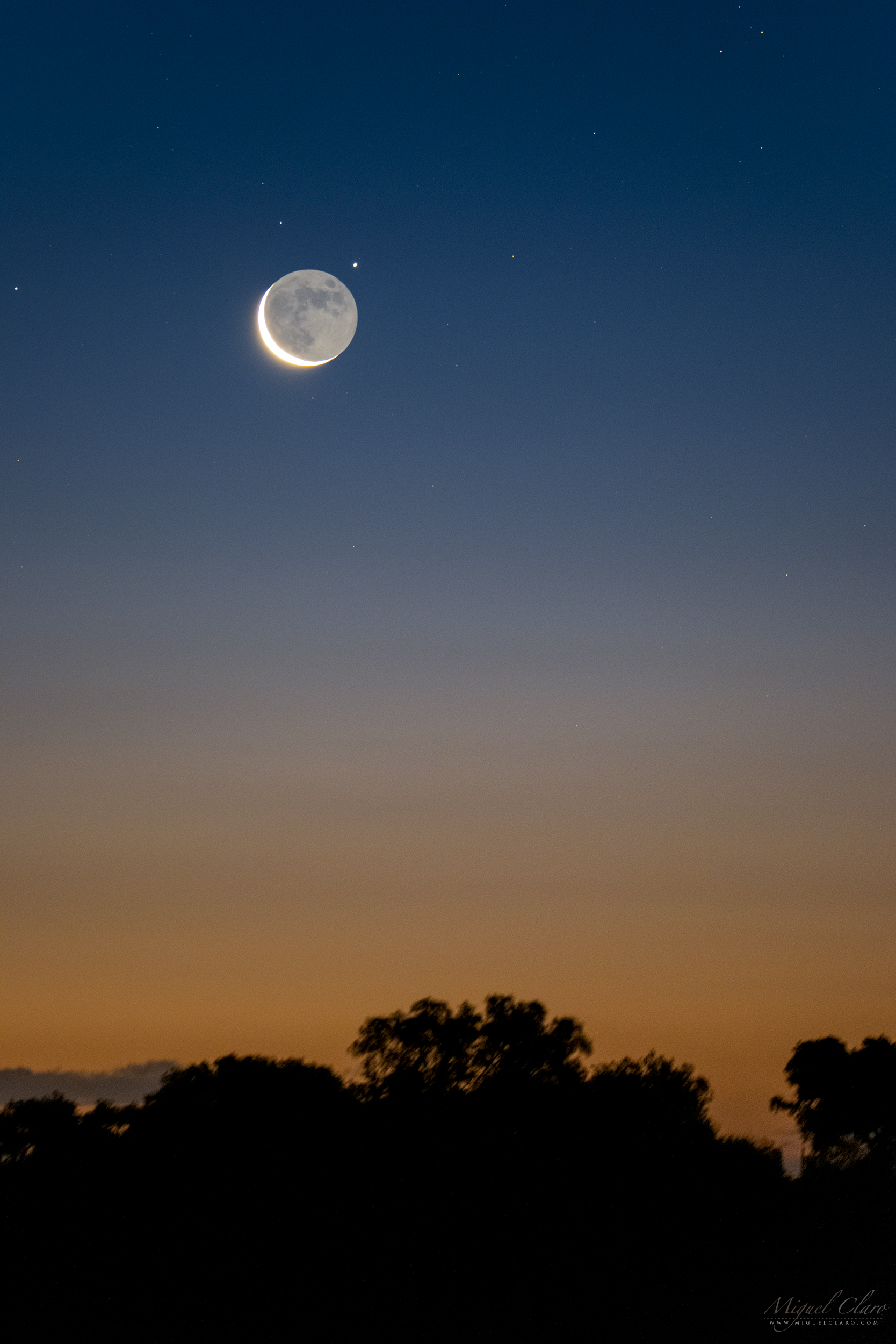
PT: A imagem revela um forte Earthshine Lunar na fase de Quarto Minguante, captado durante o Crepúsculo Náutico de dia 2 de fevereiro de 2019, poucos minutos depois de terminar uma ocultação do planeta Saturno, visível no canto superior direito da lua como um ponto oblongo pálido de tonalidade amarela-esbranquiçada. O pequeno ponto de luz visível muito perto do planeta, é Titan, uma das luas mais conhecidas do planeta Saturno. A imagem foi captada a partir do hotel rural Nave Terra, localizado no Alandroal, região do Dark Sky® Alqueva, Portugal.
A Lunar Earthshine Close to Planet Saturn and Titan

The image reveals a strong Earthshine of the Waning Crescent Moon captured during the nautical twilight on the 2nd day of February 2019, just few minutes after ending an occultation of planet Saturn which is visible in the upper right edge of the moon, as a white-yellow pale oblong dot. The “faint star” visible very close to the planet, is Titan, the well known moon of Saturn. The image was captured from a rural hotel called Nave Terra, located in Alandroal, in Dark Sky® Alqueva territory, Portugal..
PT: A imagem revela um forte Earthshine Lunar na fase de Quarto Minguante, captado durante o Crepúsculo Náutico de dia 2 de fevereiro de 2019, poucos minutos depois de terminar uma ocultação do planeta Saturno, visível no canto superior direito da lua como um ponto oblongo pálido de tonalidade amarela-esbranquiçada. O pequeno ponto de luz visível muito perto do planeta, é Titan, uma das luas mais conhecidas do planeta Saturno. A imagem foi captada a partir do hotel rural Nave Terra, localizado no Alandroal, região do Dark Sky® Alqueva, Portugal.
Venus and Jupiter shinning at Dawn in the Final Stage of the Lunar Eclipse

A panorama captured at dawn in the final stage of the Lunar Eclipse, reveals an increasing light of the lunar disk immersed in a thin layer of clouds, while in the opposite direction (at left) the brightest planets of the night sky – Venus and Jupiter – are shinning in a very close alignment, only separated by approximately 2,5 degrees from Jupiter, Venus is also featuring a blueish nice corona, due to a presence of tiny water droplets in thin clouds, which diffract the light of bright heavenly bodies working as a natural diffuse filter. During a celestial event like that, is incredible to notice huge changes on the reflected light that illuminates the ground. The image was captured in Mina de São Domingos, an old mine near Mértola, Dark Sky® Alqueva, Portugal, that was the center of metallurgical activities on extracted minerals dozens years ago. The areas of heaps, slag and channels of water, give the landscape a “lunar” aspect.
PT: Um panorama captado ao amanhecer no estágio final do Eclipse Lunar de 2019, revela uma luz crescente do disco lunar imerso em uma fina camada de nuvens, enquanto na direção oposta (à esquerda) os planetas mais brilhantes do céu noturno – Vénus e Júpiter – brilham num alinhamento próximo. Separado apenas por cerca de 2,5 graus de Júpiter, Vénus apresenta uma corona azulada, devido à presença de pequenas gotículas de água em nuvens finas, que difractam a luz de corpos celestes brilhantes trabalhando como um filtro difuso natural. Durante um evento celestial como este, é incrível notar grandes mudanças na luz refletida que ilumina o solo. A imagem foi captada na Mina de São Domingos, numa antiga mina perto de Mértola, na reserva Dark Sky® Alqueva, Portugal, que foi no passado o centro das atividades metalúrgicas dos minerais extraídos da região. As áreas de escombreiras, escórias e canais de água, dão à paisagem um aspecto “lunar”..
A Close-up View of the Moon While Immersed in a Lunar Corona

The image shows a close-up view of a red dark Moon immersed in the blue hue from a Lunar Corona, taken with a telephoto lens during the Total Lunar Eclipse of 2019, on 21th January, as seen from Mina de São Domingos in Dark Sky® Alqueva Mértola, Portugal. During a lunar eclipse, the moon passes through Earth’s shadow, giving the natural satellite a blood-red hue. For being near the closest point to our planet Earth, this Moon was also called a “Super Moon”. The next total lunar eclipse will be in 2021. A Lunar Corona is formed while bright moonlight is diffracted by water droplets in thin clouds, drifting in front of the lunar disk. Below is also visible a poster with this close-up view and a sequence of totality ending with a lunar corona.
PT: A imagem mostra um close-up de uma lua cheia vermelha e escurecida, envolta numa corona lunar captada com teleobjetiva durante o Eclipse Total Lunar ocorrido a 21 de Janeiro de 2019, captado a partir do complexo mineiro de São Domingos, no Dark Sky® Alqueva Mértola, em Portugal. Durante um eclipse lunar, a lua passa pela sombra da Terra, dando ao nosso satélite natural uma tonalidade vermelho-sangue. Por se encontrar no ponto orbital mais próximo da Terra, esta Lua é também apelidada de Super Lua. O próximo Eclipse Total da Lua ocorrerá em 2021. A corona forma-se enquanto o brilho da lua é difractado por gotículas de água em nuvens finas, flutuando assim na frente do disco lunar. Acima, é ainda possível ver um poster com este close-up da Lua e uma sequência fotográfica da totalidade, a terminar com uma corona lunar.
The Path of Totality and a Lunar Corona

A photo time lapse sequence shows the path of totality during the Total Lunar Eclipse of 2019, on 21th January, as seen from Mina de São Domingos in Dark Sky® Alqueva Mértola, Portugal, ending with a Lunar Corona that was formed while bright moonlight was diffracted by water droplets in thin clouds, drifting in front of the lunar disk. During a lunar eclipse, the moon passes through Earth’s shadow, giving the natural satellite a blood-red hue. For being near the closest point to our planet Earth, this Moon was also called a “Super Moon”. The next total lunar eclipse will be in 2021. During a celestial event like that, is incredible to notice huge changes on the reflected light that illuminates the ground. Some stars are also reflected in a small puddle of acid water from Achada do Gamo, that was – since the beginning of modern mining activities in the São Domingos Mine – the center of metallurgical activities on extracted minerals. The areas of heaps, slag and channels of water, give the landscape a “lunar” aspect. The heaps are composed of different materials with high levels of metals, such as slag and ash, whose leaching through the rainwater leads to the production of acid mine drainage, usually with an ocher or reddish color. Below is also visible a poster with a close-up view of the Moon immersed in the blue hue from the corona.
PT: A imagem mostra uma foto-sequência onde é possível ver o caminho da Lua percorrido durante a fase da totalidade durante o Eclipse Total Lunar ocorrido a 21 de Janeiro de 2019, captado a partir do complexo da Mina de São Domingos, no Dark Sky® Alqueva Mértola, em Portugal. A sequência termina com uma corona lunar, que se forma enquanto o brilho da lua é difractado por gotículas de água em nuvens finas, flutuando assim na frente do disco lunar.. Durante um eclipse lunar, a lua passa pela sombra da Terra, dando ao nosso satélite natural uma tonalidade vermelho-sangue. Por se encontrar no ponto orbital mais próximo da Terra, esta Lua é também apelidada de Super Lua. O próximo Eclipse Total da Lua ocorrerá em 2021. Durante um evento celestial como este, é incrível como se notam grandes mudanças na luz refletida que ilumina o solo. Algumas estrelas reflectem-se também nas águas ácidas da Achada do Gamo, que foi desde o início das atividades modernas de mineração na Mina de São Domingos, o centro das atividades metalúrgicas sobre os minérios extraídos. As áreas de escombreiras, escórias e canais de água, dão à paisagem um aspecto “lunar”. As escombreiras são constituídas por diferentes materiais com teores elevados em metais, como escórias e cinzas, cuja lixiviação através das águas das chuvas leva à produção de águas ácidas (‘acid mine drainage’), geralmente com uma cor ocre ou avermelhada. Acima, é ainda possível ver um poster com um close-up da Lua enquanto esta estava envolta pelo azul da corona.
Lunar Eclipse Trails

A startrail sequence shows the path of totality during the Total Lunar Eclipse of 2019, on 21th January, as seen from Mina de São Domingos in Dark Sky® Alqueva Mértola, Portugal. During a lunar eclipse, the moon passes through Earth’s shadow, giving the natural satellite a blood-red hue. For being near the closest point to our planet Earth, this Moon was also called a “Super Moon”. The next total lunar eclipse will be in 2021. During a celestial event like that, is incredible to notice huge changes on the reflected light that illuminates the ground. Some stars are also reflected in a small puddle of acid water from Achada do Gamo, that was – since the beginning of modern mining activities in the São Domingos Mine – the center of metallurgical activities on extracted minerals. The areas of heaps, slag and channels of water, give the landscape a “lunar” aspect. The heaps are composed of different materials with high levels of metals, such as slag and ash, whose leaching through the rainwater leads to the production of acid mine drainage, usually with an ocher or reddish color
PT: A imagem mostra um startrail onde é possível ver o caminho da Lua percorrido durante a fase da totalidade durante o Eclipse Total Lunar ocorrido a 21 de Janeiro de 2019, captado a partir do complexo da Mina de São Domingos, no Dark Sky® Alqueva Mértola, em Portugal. Durante um eclipse lunar, a lua passa pela sombra da Terra, dando ao nosso satélite natural uma tonalidade vermelho-sangue. Por se encontrar no ponto orbital mais próximo da Terra, esta Lua é também apelidada de Super Lua. O próximo Eclipse Total da Lua ocorrerá em 2021. Durante um evento celestial como este, é incrível como se notam grandes mudanças na luz refletida que ilumina o solo. Algumas estrelas reflectem-se também nas águas ácidas da Achada do Gamo, que foi desde o início das atividades modernas de mineração na Mina de São Domingos, o centro das atividades metalúrgicas sobre os minérios extraídos. As áreas de escombreiras, escórias e canais de água, dão à paisagem um aspecto “lunar”. As escombreiras são constituídas por diferentes materiais com teores elevados em metais, como escórias e cinzas, cuja lixiviação através das águas das chuvas leva à produção de águas ácidas (‘acid mine drainage’), geralmente com uma cor ocre ou avermelhada.
A Moon Sequence of the Total Lunar Eclipse of 2019

A photo time lapse sequence shows the path of totality during the Total Lunar Eclipse of 2019, on 21th January, as seen from Mina de São Domingos in Dark Sky® Alqueva Mértola, Portugal. During a lunar eclipse, the moon passes through Earth’s shadow, giving the natural satellite a blood-red hue. For being near the closest point to our planet Earth, this Moon was also called a “Super Moon”. The next total lunar eclipse will be in 2021. During a celestial event like that, is incredible to notice huge changes on the reflected light that illuminates the ground. Some stars are also reflected in a small puddle of acid water from Achada do Gamo, that was – since the beginning of modern mining activities in the São Domingos Mine – the center of metallurgical activities on extracted minerals. The areas of heaps, slag and channels of water, give the landscape a “lunar” aspect. The heaps are composed of different materials with high levels of metals, such as slag and ash, whose leaching through the rainwater leads to the production of acid mine drainage, usually with an ocher or reddish color
PT: A imagem mostra uma foto-sequência onde é possível ver o caminho da Lua percorrido durante a fase da totalidade durante o Eclipse Total Lunar ocorrido a 21 de Janeiro de 2019, captado a partir do complexo da Mina de São Domingos, no Dark Sky® Alqueva Mértola, em Portugal. Durante um eclipse lunar, a lua passa pela sombra da Terra, dando ao nosso satélite natural uma tonalidade vermelho-sangue. Por se encontrar no ponto orbital mais próximo da Terra, esta Lua é também apelidada de Super Lua. O próximo Eclipse Total da Lua ocorrerá em 2021. Durante um evento celestial como este, é incrível como se notam grandes mudanças na luz refletida que ilumina o solo. Algumas estrelas reflectem-se também nas águas ácidas da Achada do Gamo, que foi desde o início das atividades modernas de mineração na Mina de São Domingos, o centro das atividades metalúrgicas sobre os minérios extraídos. As áreas de escombreiras, escórias e canais de água, dão à paisagem um aspecto “lunar”. As escombreiras são constituídas por diferentes materiais com teores elevados em metais, como escórias e cinzas, cuja lixiviação através das águas das chuvas leva à produção de águas ácidas (‘acid mine drainage’), geralmente com uma cor ocre ou avermelhada.
Winter Corona Surrounding a Full Cold Moon

This relatively abstract view captured in a double exposure with focus stacking, shows the Full Moon of December, behind a layer of clouds and immersed between dozens of branches from a foreground tree. The colourful hue that surrounds the moon, is a lunar corona formed while bright moonlight is diffracted by water droplets in thin clouds, drifting in front of the lunar disk. The image was captured in the historic centre of Évora, a UNESCO World Heritage site, located in Dark Sky® Alqueva reserve, Portugal. According to the Old Farmer’s Almanac, the December full moon is also called the “Full Cold Moon”. The last time a full moon coincided with the solstice was in 2010, and the next will be in 2094.
PT: Uma visão relativamente abstrata captada em uma dupla exposição com focus stacking, mostra uma Lua Cheia envolta numa fina camada de nuvens e imersa entre dezenas de galhos de uma árvore que em contra-luz, se destaca em primeiro plano. As tonalidades coloridas que circundam a lua, são provocadas por um corona lunar, que se forma enquanto o brilho da lua é difractado por gotículas de água em nuvens finas, flutuando assim na frente do disco lunar. A imagem foi captada no centro histórico de Évora, Património Mundial da UNESCO, e inserido na reserva Dark Sky® Alqueva. De acordo com o Almanaque do Velho Fazendeiro, a lua cheia de dezembro também é chamada de “Full Cold Moon”. A última vez que uma lua cheia coincidiu com o solstício de inverno foi em 2010, sendo que a próxima só voltará a ocorrer em 2094.
All Sky View of Geminids Meteor Shower and Comet 46P/Wirtanen

A fisheye full dome view from headquarters of Dark Sky® Alqueva reserve, in Cumeada, shows a moonlight night after the peak of Geminids meteor shower. This composite shows the radiant of Geminids, located in Gemini constellation and near the star Castor, is combining 8 images where meteors were captured during a period of about 3h. Comet 46P/Wirtanen is also visible in Taurus constellation, making an historic close approach to Earth. The beautiful greenish-blue coma is very well visible even in this ultra wide-field view. High in the sky, and not faraway from 46/P Wirtanen, is shinning bright the blueish cluster of hot and young stars known as Pleiades (M45).
PT: Uma visão fisheye full dome captada a partir da sede da reserva Dark Sky® Alqueva, na Cumeada, mostra uma noite de luar após o pico da chuva de meteoros Geminídeas. Este compósito mostra o radiante da chuva de meteoros localizado na constelação de Gémeos, perto da estrela Castor, combinando 8 imagens de meteoros captados durante um período de cerca de 3h. O cometa 46P / Wirtanen, é também é visível na constelação do Touro, fazendo uma aproximação histórica à Terra. A tonalidade azul-esverdeada do coma – a nuvem de poeira e gás que circunda o núcleo de um cometa – é bem visível nesta imagem “all sky” ultra grande-angular. Alto no céu, e não muito longe do 46/P Wirtanen, brilha ainda em tons de azul, o aglomerado de estrelas quentes e jovens conhecidas como Pleiades (M45).
A Panoramic Views Shows the Moonlight over Niagara Falls

Created by glacier activity around 10000 years ago, Niagara Falls is one the of the World’s Natural Wonders. Located on the border of Ontario, Canada and New York State, USA, Niagara Falls are made up of 3 waterfalls, the American Falls, the Bridal Veil Falls and the Horseshoe Falls. The 3 waterfalls combined, is producing the highest flow rate of any waterfall on Earth. The Horseshoe Falls are 180 feet (57 meters) high and allow 6 million cubic feet (168,000 cubic meters) of water every minute during peak daytime tourist hours, “that is about a million bathtubs full of water every minute”! Although, according this and having in mind the total volume of our natural satellite, the Moon, with 2.1958e10 km3 it would need to take of about 248 years to fill up the entire sphere that represents the body of the Moon. The rapids above the Falls reach a maximum speed of 40 km/h, but the fastest speeds occur at the Falls with 109 km/h. Niagara River expert, Wes Hill, estimates that 90 % of the fish can survive from the huge drop. At the current rate of erosion, scientists believe that the Niagara Falls will be gone in around 50000 years, luckily you still have time to be one of the 30 million people that every year are visiting the place. This panoramic view shows the Moon and Mars above American Falls, just few minutes after starting the light show that illuminates in different hues the 3 Falls. Below, a boat from Hornblower Niagara Cruises, not so iconic as The Maid of the Mist that made its first trip in 1846, is carrying aboard hundreds of people that in the background, has a massive flow of 567,811 liters of water falling each second.
PT: Criada pela atividade glacial há cerca de 10000 anos, as Cataratas do Niágara são uma das maravilhas naturais do mundo. Localizadas na fronteira de Ontário, Canadá e Estado de Nova York, EUA, as Cataratas do Niágara são compostas por 3 cataratas, as Cataratas Americanas, as Cataratas de Bridal Veil e as Cataratas Canadenses. As Cataratas Horseshoe têm 180 pés (57 metros) de altura e permitem a passagem de 168.000 metros cúbicos de água a cada minuto, durante o dia e no horário de pico turístico, isto é, cerca de um milhão de banheiras cheias de água a cada minuto! No entanto, de acordo com esses dados e tendo em mente o volume total de nosso satélite natural da Tera, a Lua, com 2.1958e10 km3, seria necessário cerca de 248 anos para preencher toda a esfera que representa o corpo da Lua. Acima das Cataratas a água atinge uma velocidade máxima de 40 km/h, mas as velocidades mais rápidas ocorrem nas Cataratas onde a água se precipita em queda livre atingindo os 109 km/h. O especialista do Rio Niágara, Wes Hill, estima que 90% dos peixes conseguem sobreviver da enorme queda. No ritmo atual de erosão, os cientistas acreditam que as Cataratas do Niágara terão desaparecido em cerca de 50000 anos, felizmente ainda terá tempo de ser uma das 30 milhões de pessoas que todos os anos visitam o local. Esta vista panorâmica mostra a Lua e Marte acima da American Falls, apenas alguns minutos depois de iniciar o show de luzes que ilumina em diferentes tons as 3 cataratas. Abaixo, um barco da Hornblower Niagara Cruises, não tão icónico como o Maid of the Mist que fez a sua primeira viagem em 1846, carrega a bordo centenas de pessoas que em pano de fundo têm um fluxo de 567.811 litros de água caindo a cada segundo da viagem.
A Pinky Sky with a Golden Moon above Niagara Falls

Created by glacier activity around 10000 years ago, Niagara Falls is one the of the World’s Natural Wonders. Located on the border of Ontario, Canada and New York State, USA, Niagara Falls are made up of 3 waterfalls, the American Falls, the Bridal Veil Falls and the Horseshoe Falls. The 3 waterfalls combined, is producing the highest flow rate of any waterfall on Earth. The Horseshoe Falls are 180 feet (57 meters) high and allow 6 million cubic feet (168,000 cubic meters) of water every minute during peak daytime tourist hours, “that is about a million bathtubs full of water every minute”! Although, according this and having in mind the total volume of our natural satellite, the Moon, with 2.1958e10 km3 it would need to take of about 248 years to fill up the entire sphere that represents the body of the Moon. The rapids above the Falls reach a maximum speed of 40 km/h, but the fastest speeds occur at the Falls with 109 km/h. Niagara River expert, Wes Hill, estimates that 90 % of the fish can survive from the huge drop. At the current rate of erosion, scientists believe that the Niagara Falls will be gone in around 50000 years, luckily you still have time to be one of the 30 million people that every year are visiting the place. The image shows a golden crescent moon against the pink band from anti-twilight arch, or “Belt of Venus”, visible few minutes after the sunset when lots of birds are flying above American Falls & Bridal Veil Falls. Below, a boat from Hornblower Niagara Cruises, not so iconic as The Maid of the Mist that made its first trip in 1846, is carrying aboard hundreds of people that in the background has a massive flow of 567,811 liters of water falling each second.
PT: Criada pela atividade glacial há cerca de 10000 anos, as Cataratas do Niágara são uma das maravilhas naturais do mundo. Localizadas na fronteira de Ontário, Canadá e Estado de Nova York, EUA, as Cataratas do Niágara são compostas por 3 cataratas, as Cataratas Americanas, as Cataratas de Bridal Veil e as Cataratas Canadenses. As Cataratas Horseshoe têm 180 pés (57 metros) de altura e permitem a passagem de 168.000 metros cúbicos de água a cada minuto, durante o dia e no horário de pico turístico, isto é, cerca de um milhão de banheiras cheias de água a cada minuto! No entanto, de acordo com esses dados e tendo em mente o volume total de nosso satélite natural da Tera, a Lua, com 2.1958e10 km3, seria necessário cerca de 248 anos para preencher toda a esfera que representa o corpo da Lua. Acima das Cataratas a água atinge uma velocidade máxima de 40 km/h, mas as velocidades mais rápidas ocorrem nas Cataratas onde a água se precipita em queda livre atingindo os 109 km/h. O especialista do Rio Niágara, Wes Hill, estima que 90% dos peixes conseguem sobreviver da enorme queda. No ritmo atual de erosão, os cientistas acreditam que as Cataratas do Niágara terão desaparecido em cerca de 50000 anos, felizmente ainda terá tempo de ser uma das 30 milhões de pessoas que todos os anos visitam o local. A imagem mostra uma lua crescente dourada contra a faixa rosa do arco anti-crepuscular, ou também conhecido por Belt of Venus, poucos minutos após o pôr do sol, quando muitos pássaros voam acima de American Falls e Bridal Veil Falls. Abaixo, um barco da Hornblower Niagara Cruises, não tão icónico como o Maid of the Mist que fez a sua primeira viagem em 1846, carrega a bordo centenas de pessoas que em pano de fundo têm um fluxo de 567.811 litros de água caindo a cada segundo da viagem.

An Eclipsed Moon with Mars, Milky Way with Saturn, and a Satellite near Jupiter

Captured 15 minutes after the end of totality during the longest Total Lunar Eclipse of the Century, the scene shows the bright light of a partially eclipsed Moon very close to the red planet Mars. With the galactic core featuring planet Saturn above Sagittarius, the Milky Way is well visible crossing the center of the picture, while above its arched shape, a flare from Satellite FORMOSAT-2 (ROCSAT 2) showed up high in the sky not faraway – in this wide angle view – from the bright light of planet Jupiter, seen near the right edge of the photo. This single shot was captured from Campinho, Dark Sky® Alqueva, Portugal.
PT: Captada 15 minutos após o final da totalidade durante o mais longo Eclipse Lunar Total do Século, a imagem mostra a luz brilhante de uma Lua parcialmente eclipsada muito próxima do planeta vermelho, Marte. Com o planeta Saturno no centro galáctico, a Via Láctea arqueada cruza o centro da imagem à medida que um flare do Satélite FORMOSAT-2 (ROCSAT 2) se trona visível por instantes, bem alto no céu. Por fim, à direita deste e já próximo do extremo da foto, é possível ver a luz brilhante do planeta Júpiter. Este disparo único foi captado no Campinho, Dark Sky® Alqueva, Portugal.
Visible Corona during the Partial Phase of the Total Lunar Eclipse
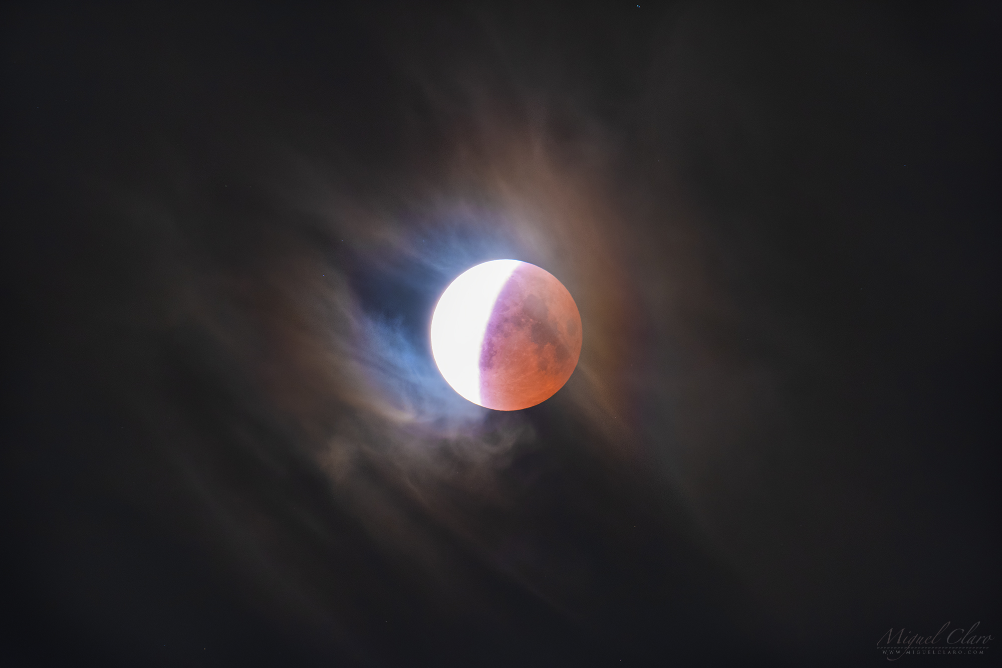
Sequence of the partial ending phase of the longest Total Lunar Eclipse of the Century, where during a few seconds some iridescent clouds and a short Lunar Corona around the eclipsed disk of the moon showed up, due to a short presence of passing clouds. While the partial phase is moving forward, we can also see the intense light of the sun catching and hiding the well known Tycho Crater.
PT: Sequência da fase final parcial do mais longo Eclipse Lunar Total do Século, onde durante alguns segundos apareceram algumas nuvens iridescentes formando uma Corona Lunar ao redor do disco eclipsado da lua. Estas formações ocorrem devido à presença de uma camada fina de nuvens que contém normalmente micro cristais de gelo que refractam a luz de Lua. Enquanto a fase parcial avança na sequência Time Lapse, também podemos ver a intensa luz solar que vai ocultando por sobre exposição a conhecida cratera Tycho.
Total Lunar Eclipse in the Twilight

The image shows a sequence of the red path left behind by the Moon during the longest Total Lunar Eclipse of the Century, as seen from Campinho, Dark Sky® Alqueva, Portugal, few minutes after the Moonrise and against a blue Twilight background. During a lunar eclipse, the moon passes through Earth’s shadow, giving the natural satellite a blood-red hue.

PT: A imagem mostra uma sequência do rasto vermelho deixado pela Lua durante o mais longo Eclipse Lunar Total do Século, captado a partir do Campinho, Dark Sky® Alqueva, Portugal, poucos minutos após o nascer da Lua e contra um fundo azul de Crepúsculo. Durante um eclipse lunar, a lua passa pela sombra da Terra, dando ao nosso satélite natural uma tonalidade vermelho-sangue.
A Full Dome View from Peak District

This full dome fisheye view, shows the sky above Peak District in a cold winter moonlight night, with a smooth presence of the Milky Way crossing the center of the image surrounded by high trees. If you climb up the mountain you will find a curious stone named Mother Cap as well as great views.
PT: Esta vista fisheye circular, mostra o céu acima de Peak District, UK, numa fria noite de luar de inverno, onde é possível ver a suave presença da Via Láctea cruzando o centro da imagem e cercada por árvores altas. Se subirmos a montanha desta região, encontraremos uma curiosa formação de pedra chamada de Mother Cap e ótimas vistas circundantes.
A Full Moon above the Medieval Village of Monsaraz

April’s full moon is known as the Pink Moon, according to the Old Farmer’s Almanac. The name comes from pink flowers that bloom in the early spring, known as ground phlox. But this April Moon is particularly good to photograph, as the sun will share the sky for about 20 minutes after the moonrise, it will work as the perfect light that still illuminates the landscape, entire fields, or in my case, the beautiful medieval village and castle of Monsaraz, in Alqueva Dark Sky® Reserve, Portugal. To create this visual impact with the illusion that the Moon seems to be so big when compared with the objects on Earth, I just had to find the right spot located at a distant of about 3.7 km away from the castle. The result is a single shot captured with a 600mm lens.
PT: A Lua cheia de abril é conhecida como a Pink Moon, de acordo com o antigo Almanaque do Fazendeiro. O nome está relacionado com as flores cor-de-rosa que florescem no início da primavera, conhecida como “ground phlox”. Mas esta Lua de Abril é particularmente boa para fotografar, pois o sol ainda compartilha o mesmo céu durante cerca de 20 minutos, após o nascimento da lua, funcionando como a luz perfeita para iluminar a paisagem, os campos ou, no meu caso, a linda vila medieval e o castelo de Monsaraz, no Dark Sky® Alqueva, Portugal. Para criar este impacto visual e a ilusão óptica de que a Lua parece ser tão grande quando comparada com os objetos em Terra, apenas tive de encontrar o local certo localizado a uma distância de cerca de 3,7 km do castelo de Monsaraz. O resultado deste disparo único, foi captado com uma lente de 600 mm de distância focal.
A Black and White Moonrise above Monsaraz Village

A more “dramatic” Black and White view shows the April’s full moon also known as the Pink Moon, according to the Old Farmer’s Almanac. The name comes from pink flowers that bloom in the early spring, known as ground phlox. But this April Moon is particularly good to photograph, as the sun will share the sky for about 20 minutes after the moonrise, it will work as the perfect light that still illuminates the landscape, entire fields, or in my case, the beautiful medieval village and castle of Monsaraz, in Alqueva Dark Sky® Reserve, Portugal. To create this visual impact with the illusion that the Moon seems to be so big when compared with the objects on Earth, I just had to find the right spot located at a distant of about 3.7 km away from the castle. The result is a single shot captured with a 600mm lens.
PT: Nesta visão mais “dramática” a Preto e Branco, é possível apreciar a Lua cheia de abril, também conhecida como Pink Moon, de acordo com o antigo Almanaque do Fazendeiro. O nome está relacionado com as flores cor-de-rosa que florescem no início da primavera, conhecida como “ground phlox”. Mas esta Lua de Abril é particularmente boa para fotografar, pois o sol ainda compartilha o mesmo céu durante cerca de 20 minutos, após o nascimento da lua, funcionando como a luz perfeita para iluminar a paisagem, os campos ou, no meu caso, a linda vila medieval e o castelo de Monsaraz, no Dark Sky® Alqueva, Portugal. Para criar este impacto visual e a ilusão óptica de que a Lua parece ser tão grande quando comparada com os objetos em Terra, apenas tive de encontrar o local certo localizado a uma distância de cerca de 3,7 km do castelo de Monsaraz. O resultado deste disparo único, foi captado com uma lente de 600 mm de distância focal.
A Perfect Triangle between Moon, Pleiades and Venus

The photo shows a Crescent Moon with a visible earthshine immersed by the Hyades star cluster, and forming an almost perfect triangle of about 9 degrees, which seems to be aligned with Pleiades star cluster at right, and below, the bright planet Venus. In the foreground, the water of Alqueva lake is reflecting the beautiful colors from nautical twilight. The image was captured in Campinho village, near the headquarter of Dark Sky Alqueva Reserve.
PT: Na foto é possível ver uma Lua Crescente com um forte Earthshine imersa pelo aglomerado estelar de Hyades e formando um triângulo quase perfeito de cerca de 9 graus, que parece estar alinhado com o aglomerado de estrelas das Pleiades à direita, e logo abaixo o brilhante planeta Vénus. Em primeiro plano, a água do lago do Alqueva reflecte as lindas cores do crepúsculo náutico. A imagem foi captada na aldeia de Campinho, perto da sede da Reserva Dark Sky Alqueva.
A Twilight Moon in La Sagrada Familia, Barcelona

This cityscape scene shows a 96% illuminated Moon, peeking through the clouds during the twilight at the right side of the Roman Catholic church of La Sagrada Familia, in Barcelona, Spain. Being the most visited landmark, was inscribed on the World Heritage list in 2005. It has the particularity of being the world’s only major church currently under construction! Designed by Catalan architect Antoni Gaudí (1852–1926) is the most important and ambitious work done by him. At the very beginning, Gaudi´s thought it would take only 10 year to build it, but on 19th of March 2017, was the 135th anniversary of the laying of the cornerstone of the Temple. Currently, 70% of the Basilica is finished and they are working on building the six central towers. The temple must be finished in 2022.
PT: Este cenário de paisagem urbana mostra uma lua iluminada a 96%, espreitando por entre as nuvens durante o crepúsculo náutico, ao lado direito da Igreja Católica Romana da Sagrada Familia, em Barcelona, Espanha. Sendo um dos marcos mais visitados, foi inscrito em 2015 na lista da UNESCO como Património Mundial da Humanidade. Tendo a particularidade de ser a única grande igreja do mundo atualmente em construção, foi projectada pelo arquitecto catalão Antoni Gaudí (1852-1926) é o trabalho mais importante e ambicioso feito por ele. No início, Gaudi pensou que levaria apenas 10 anos para construir a Basílica, mas em 19 de março de 2017, comemorou-se o 135º aniversário da colocação da pedra fundamental do Templo. Atualmente, 70% da Basílica está acabada e sendo que se está a trabalhar na construção das seis torres centrais. O templo deverá estar terminado apenas em 2022.

Golden Moonrise above the City of Lisbon

A lovely cityscape view captured from a rooftop shows the Full Moon rising above the city of Lisbon. According to modern folklore, the second Full Moon in a calendar month is called “Blue Moon”. Rather than Blue, the rising moon can appear yellow-orange when it is near the horizon due to the way light scatters in the atmosphere. When the moon is low on the horizon, moonlight passes through more of Earth’s atmosphere than when it is overhead. By the time light reaches the observer, the blue and green light has already been scattered, leaving only the red-orange light. We’ve already had one Blue Moon in January 2018, and the last time this rare event of two Blue Moons occurred in such quick succession was January and March of 1999.
PT: Uma vista fantástica em ambiente citadino captada a partir de um telhado, mostra o nascer da Lua Cheia acima da cidade de Lisboa. De acordo com o folclore moderno, a segunda Lua Cheia que ocorre no mesmo mês é chamada de “Lua Azul”. Contudo, ao invés de azul, a lua pode aparecer num tom amarelo alaranjado quando está mais perto do horizonte devido à forma como a luz se espalha na atmosfera. Este ano já tivemos uma Lua Azul em janeiro de 2018, e a última vez que este evento raro aconteceu – de duas luas azuis ocorrerem num tão curto espaço de tempo sequencial – foi em Janeiro e Março de 1999.
The “Blue Moon” rising behind a layer of clouds above the City of Lisbon

A lovely cityscape view captured from a rooftop shows the Full Moon rising above the city of Lisbon. According to modern folklore, the second Full Moon in a calendar month is called “Blue Moon”. Rather than Blue, the rising moon can appear yellow-orange when it is near the horizon due to the way light scatters in the atmosphere. When the moon is low on the horizon, moonlight passes through more of Earth’s atmosphere than when it is overhead. By the time light reaches the observer, the blue and green light has already been scattered, leaving only the red-orange light. We’ve already had one Blue Moon in January 2018, and the last time this rare event of two Blue Moons occurred in such quick succession was January and March of 1999.
PT: Uma vista fantástica em ambiente citadino captada a partir de um telhado, mostra o nascer da Lua Cheia acima da cidade de Lisboa. De acordo com o folclore moderno, a segunda Lua Cheia que ocorre no mesmo mês é chamada de “Lua Azul”. Contudo, ao invés de azul, a lua pode aparecer num tom amarelo alaranjado quando está mais perto do horizonte devido à forma como a luz se espalha na atmosfera. Este ano já tivemos uma Lua Azul em janeiro de 2018, e a última vez que este evento raro aconteceu – de duas luas azuis ocorrerem num tão curto espaço de tempo sequencial – foi em Janeiro e Março de 1999.

The “Blue Moon” rising above the City of Lisbon
A lovely cityscape view captured from a rooftop shows the Full Moon rising above the city of Lisbon. According to modern folklore, the second Full Moon in a calendar month is called “Blue Moon”. Rather than Blue, the rising moon can appear yellow-orange when it is near the horizon due to the way light scatters in the atmosphere. When the moon is low on the horizon, moonlight passes through more of Earth’s atmosphere than when it is overhead. By the time light reaches the observer, the blue and green light has already been scattered, leaving only the red-orange light. We’ve already had one Blue Moon in January 2018, and the last time this rare event of two Blue Moons occurred in such quick succession was January and March of 1999.
PT: Uma vista fantástica em ambiente citadino captada a partir de um telhado, mostra o nascer da Lua Cheia acima da cidade de Lisboa. De acordo com o folclore moderno, a segunda Lua Cheia que ocorre no mesmo mês é chamada de “Lua Azul”. Contudo, ao invés de azul, a lua pode aparecer num tom amarelo alaranjado quando está mais perto do horizonte devido à forma como a luz se espalha na atmosfera. Este ano já tivemos uma Lua Azul em janeiro de 2018, e a última vez que este evento raro aconteceu – de duas luas azuis ocorrerem num tão curto espaço de tempo sequencial – foi em Janeiro e Março de 1999.
A Dreaming Waning Crescent Moon
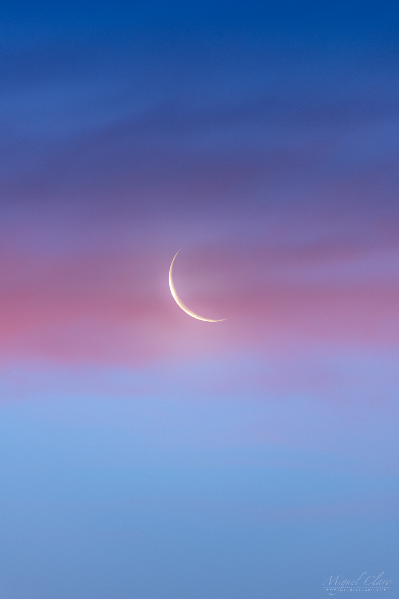
The photo shows a slightly Waning Crescent Moon rising at Dawn, against a beautiful background from the twilight and behind a pink band of clouds, just few minutes before the Sunrise. Captured above Monsaraz and lake Alqueva, in Dark Sky® Alqueva reserve, the disk was only 6% illuminated by Sun, remind us that planet Venus also can have very similar phases, that can be seen through a telescopic view from Earth, in the right time of the year. When Venus reaches its greatest approach to Earth it shows a slightly Crescent shape – an opposite result of this Waning Crescent Moon.
PT: Na foto é possível ver uma lua minguante que se levanta às primeiras horas do dia por detrás de uma nuvem rosada contra um colorido fundo crepuscular, apenas alguns minutos antes do Sol nascer. Captada acima de Monsaraz, na reserva Dark Sky® Alqueva, com o disco lunar apenas 6% iluminado pelo Sol, relembra-nos que o Planeta Vénus também pode apresentar fases muito similares às da Lua e que podem ser vistas a partir da Terra com o auxílio de um telescópio, na altura certa do ano. Quando Vénus atinge o ponto de máxima aproximação à Terra, apresenta uma magnitude de -4.5, tornando-se o planeta mais brilhante da esfera celeste, revelando uma fase Crescente similar, mas oposta à que a Lua apresenta nesta fotografia.
A Waning Crescent Moon Behind a Pinky Band of Clouds

The photo shows a Waning Crescent Moon rising at Dawn, against a beautiful background from the twilight and behind a pink band of clouds, just few minutes before the Sunrise. Captured above Monsaraz and lake Alqueva, in Dark Sky® Alqueva reserve, and due to the fact that during this time of the Month the disk was only 6% illuminated by Sun, we can clearly distinguish the Earthshine, a phenomenon related to that part of the Moon that is not directly illuminated by the Sun, but by the reflected light from Earth itself.
PT: Na foto é possível ver uma lua minguante que se levanta às primeiras horas do dia por detrás de uma nuvem rosada contra um colorido fundo crepuscular, apenas alguns minutos antes do Sol nascer. Captada acima de Monsaraz, na reserva Dark Sky® Alqueva, e devido ao facto de que durante este período do mês o disco lunar se encontra apenas 6% iluminado pelo Sol, podemos distinguir claramente um Earthshine, um fenómeno relacionado com a parte da Lua que não se encontra diretamente iluminada pelo Sol, mas pela luz refletida da própria Terra.
An Earthshine from the Waning Crescent Moon

The photo shows a Waning Crescent Moon rising at Dawn, against a beautiful background from the twilight, just few minutes before the Sunrise. Captured above Monsaraz and lake Alqueva, in Dark Sky® Alqueva reserve, and due to the fact that during this time of the Month the disk was only 6% illuminated by Sun, we can clearly distinguish the Earthshine, a phenomenon related to that part of the Moon that is not directly illuminated by the Sun, but by the reflected light from Earth itself.
PT: Na foto é possível ver uma lua minguante que se levanta às primeiras horas do dia, contra um colorido fundo crepuscular, apenas alguns minutos antes do Sol nascer. Captada acima de Monsaraz, na reserva Dark Sky® Alqueva, e devido ao facto de que durante este período do mês o disco lunar se encontra apenas 6% iluminado pelo Sol, podemos distinguir claramente um Earthshine, um fenómeno relacionado com a parte da Lua que não se encontra diretamente iluminada pelo Sol, mas pela luz refletida da própria Terra.

The Path of Light from a Super Blue Moon

The path of light from a Super Blue Moon is rising behind a windmill from Sesimbra, in Portugal. The second Full Moon of the month is well known as the “Blue Moon”. Supermoons happen when a full moon approximately coincides with the moon’s perigee, or a point in its orbit at which it is closest to Earth. This makes the moon appear up to 8 percent larger and 16 percent brighter than usual. The Super Moon from January 2018 was very unusual because it also happened a Total Lunar Eclipse, although, it was not visible from Portugal. Below is a Time Lapse sequence captured during Moonrise.
PT: O rasto de luz de uma Super “Blue Moon” ergue-se por detrás de um moinho de vento de Sesimbra, em Portugal. A segunda Lua cheia do mês é conhecida como a “Lua Azul” ou “Blue Moon”. As popularmente designadas Super Luas acontecem, quando uma lua cheia coincide aproximadamente com o perigeu da lua, o ponto em sua órbita que está mais próximo da Terra. Isso faz com que a lua apareça até 8% maior e 16% mais brilhante do que o normal. A Super Lua de janeiro de 2018 foi muito incomum porque também permitiu a ocorrência de um Eclipse Lunar Total, embora não fosse visível de Portugal. Abaixo está uma sequência Time Lapse captada durante o nascer da lua.
Super Blue Moon, Rising Behind a Wind Mill

A Super Blue Moon rising above a wind mill from Sesimbra, in Portugal. The second Full Moon of the month is well known as the “Blue Moon”. Supermoons happen when a full moon approximately coincides with the moon’s perigee, or a point in its orbit at which it is closest to Earth. This makes the moon appear up to 8 percent larger and 16 percent brighter than usual. The Super Moon from January 2018 was very unusual because it also happened a Total Lunar Eclipse, although, it was not visible from Portugal. Below is a Time Lapse sequence captured during Moonrise.
PT: Uma Super “Blue Moon” ergue-se acima de um moinho de vento de Sesimbra, em Portugal. A segunda Lua cheia do mês é conhecida como a “Lua Azul” ou “Blue Moon”. As popularmente designadas Super Luas acontecem, quando uma lua cheia coincide aproximadamente com o perigeu da lua, o ponto em sua órbita que está mais próximo da Terra. Isso faz com que a lua apareça até 8% maior e 16% mais brilhante do que o normal. A Super Lua de janeiro de 2018 foi muito incomum porque também permitiu a ocorrência de um Eclipse Lunar Total, embora não fosse visível de Portugal. Abaixo está uma sequência Time Lapse captada durante o nascer da lua.
Lunar Corona above Town Hall in Grand Place

This cityscape shows a colourful lunar corona at the left side of the Town Hall in the city of Brussels, capital of European Union (EU). The lunar corona is formed while bright moonlight is diffracted by water droplets in thin clouds, drifting in front of the lunar disk. The beautiful building in the foreground is the Town Hall of the City of Brussels, a Gothic building from the Middle Ages – between 1401 and 1455 – and made the Grand Place the seat of municipal power. The major tower have 96 metres (315 ft) high, and is capped by a 4-metre (12 ft) statue of Saint Michael slaying a demon. It is located on the famous Grand Place in Brussels, Belgium, and is the only remaining medieval building of the Grand Place and is considered a masterpiece of civil Gothic architecture and more particularly of Brabantine Gothic. As a UNESCO World Heritage Site, Grand-Place testifies in particular to the success of Brussels, mercantile city of northern Europe that, at the height of its prosperity, rose from the terrible bombardment inflicted by the troops of Louis XIV in 1695. Destroyed in three days, this gothic building has survived.
PT: Esta paisagem urbana mostra uma colorida coroa lunar à esquerda da Câmara Municipal da cidade de Bruxelas, capital da União Europeia (UE). A coroa lunar é formada devido à difração da luz brilhante do luar nas gotas de água presentes em nuvens finas, que transitam na frente do disco lunar. O magnífico edifício em primeiro plano, é a Câmara Municipal da Cidade de Bruxelas, um edifício gótico da Idade Média – entre 1401 e 1455 – que fez da Grand Place o lugar do poder municipal. A torre principal tem 96 metros (315 pés) de altura e está coberta por uma estátua de 4 metros (12 pés) de Saint Michael, matando um demónio. Localizado na famosa Grand Place, em Bruxelas, na Bélgica, é o único edifício medieval que permanece da Grand Place original e é considerado uma obra-prima da arquitetura gótica civil e mais particularmente do Brabantine Gothic. Incluído na lista do Património Mundial da UNESCO, a Grand-Place atesta, em particular, o sucesso de Bruxelas, cidade mercantil do norte da Europa, que, no auge de sua prosperidade, surgiu do terrível bombardeamento infligido pelas tropas de Louis XIV em 1695. Totalmente destruída em três dias, este edifício gótico foi dos únicos que sobreviveu ao bombardeamento
Lunar Christmas Earthshine above Mértola Castle

Captured one day after the new moon during the Christmas week, the moon was only 2% illuminated by the sunlight. Though, we can clearly distinguish the entire disk due to a phenomenon called Lunar Earthshine. In the foreground, located in a top hill, is a beautiful well-preserved medieval castle from Mértola village, in Dark Sky® Alqueva Reserve, decorated with Christmas lights around the walls and by coincidence very well aligned with the crescent moon, forming the perfect frame for a Christmas Card.
PT: Captada no dia após a lua nova e durante a semana que antecede o Natal, a lua encontrava-se 2% iluminada pela luz solar directa. No entanto, é possível distinguir claramente todo o disco devido a um fenómeno chamado Lunar Earthshine. Em primeiro plano, localizado numa colina superior, encontra-se o bem preservado e belo castelo da vila de Mértola, na Reserva Dark Sky® Alqueva, decorado com luzes de Natal ao redor das paredes e por coincidência muito bem alinhado com a lua crescente, forma o par perfeito para um Postal de Natal.
Slightly Crescent Moon above Mértola Village

Captured one day after the new moon during the Christmas week, the moon was only 2% illuminated by the sunlight. Though, we can clearly distinguish the entire disk due to a phenomenon called Lunar Earthshine. In the foreground, located in a top hill, is a beautiful well-preserved medieval castle from Mértola village, in Dark Sky® Alqueva Reserve, decorated with Christmas lights around the walls and by coincidence very well aligned with the crescent moon, forming the perfect frame for a Christmas Card.
PT: Captada no dia após a lua nova e durante a semana que antecede o Natal, a lua encontrava-se 2% iluminada pela luz solar directa. No entanto, é possível distinguir claramente todo o disco devido a um fenómeno chamado Lunar Earthshine. Em primeiro plano, localizado numa colina superior, encontra-se o bem preservado e belo castelo da vila de Mértola, na Reserva Dark Sky® Alqueva, decorado com luzes de Natal ao redor das paredes e por coincidência muito bem alinhado com a lua crescente, forma o par perfeito para um Postal de Natal.
Mina de São Domingos, an Open Hole to a Chemical Universe

The magnificent chemical landscape from Achada do Gamo, seems to show an hole to the Universe where we can immerse through a puddle of acid waters, reflecting the starlight from Scorpius and planet Saturn shinning bright against the galaxy core. Since the beginning of modern mining activities in the São Domingos Mine, Achada do Gamo was the center of metallurgical activities on extracted minerals. Some heavy elements presented in these minerals have been created billions of years ago in those stars and through supernovae explosions. The gold for example was made from neutron stars during collisions. Although, silver production occurs in less massive stars than those that produce gold—and through an entirely different type of nuclear fusion, called the weak r-process. The sites of nuclear creation of some elements, such as copper, are not really well known and are continuing topics of observational and computational research. The areas of heaps, slag and channels of water, give the landscape a “lunar” aspect. The heaps are composed of different materials with high levels of metals, such as slag and ash, whose leaching through the rainwater leads to the production of acid mine drainage, usually with an ocher or reddish color.|
São Domingos Mine is located in Baixo Alentejo, about 240 km from Lisbon, in the municipality of Mértola, which recently joined the Dark Sky® Alqueva Route for the great quality of the night sky. The São Domingos mining area is part of the Iberian Pyrite Range and is a decisive source of basic metals (S, Zn, Pb, Sn, Ag, Au, Fe, Co, Cd, etc.) and other elements such as sulfur (S). It has been a sought after place for the extraction of ores since antiquity, with evidence of gold, silver and copper mining in the pre-Roman and Roman times. The pyritic deposit of São Domingos (St. Dominic) was explored in various historical periods, namely: for several centuries of the first millennium BC (Eastern period), during the period between 14 BC and 395 AD (Roman period), during the Islamic period and during the modern period that was initiated in 1858 for the extraction of copper, gold and silver and was maintained until 1966, the year in which the reserves were considered exhausted. During this period, the work was done in the open air up to 120 meters deep, with work continued through wells and galleries up to 400 meters. Over 108 years of regular exploration, more than 20 million tons of materials were removed from the site, producing about 14.7 million tons of waste accumulated in heaps up to 14 meters high with a dozen different materials such as pyrite , gossan, slag, ash, iron oxides, barren rock, sludge, debris, etc.
PT: A magnífica paisagem química de Achada do Gamo, parece mostrar um buraco para o Universo onde podemos mergulhar através de um charco de águas ácidas, refletindo a luz das estrelas do Escorpião e o planeta Saturno brilhando contra o núcleo da galáxia. Desde o início das modernas atividades de mineração na mina de São Domingos, a Achada do Gamo foi o centro das atividades metalúrgicas nos minerais extraídos. Alguns elementos pesados presentes nestes minerais foram criados há milhares de milhões de anos atrás nessas estrelas e através de explosões de supernovas. O ouro, por exemplo, foi feito a partir de estrelas de neutrões durante colisões. Apesar disso, a produção de prata ocorre em estrelas menos maciças do que aquelas que produzem ouro – e através de um tipo completamente diferente de fusão nuclear, chamado de processo-r fraco. As áreas de montes, escórias e canais de água, dão à paisagem um aspecto “lunar” que lhe confere um cenário ímpar. Os montes são compostos de diferentes materiais com altos níveis de metais, como escórias e cinzas, cuja lixiviação através da água da chuva leva à produção de drenagem de minas ácidas, geralmente com uma cor ocre ou avermelhada.
A Mina de São Domingos, situa-se no Baixo Alentejo, a cerca de 240 km de Lisboa, no concelho de Mértola, que passou a integrar recentemente a Rota Dark Sky® Alqueva pela grande qualidade do seu céu escuro. A área mineira de São Domingos, está inserida na Faixa Piritosa Ibérica e constitui uma fonte decisiva de metais básicos (Cu, Zn, Pb, Sn, Ag, Au, Fe, Co, Cd, etc.) e de outros elementos como o enxofre (S). Foi desde a Antiguidade um local procurado para a extracção de minérios, existindo indícios de trabalhos de extracção de ouro, prata e cobre no período pré-romano e romano. O depósito pirítico de São Domingos foi explorado em diversos períodos históricos, nomeadamente: durante vários séculos do primeiro milénio a.C. (período Oriental), durante o período que mediou entre o ano 14 a.C. e o ano de 395 d.C. (período romano), durante o período islâmico e durante o período moderno que se iniciou em 1858 para a extracção de cobre, ouro e prata e manteve-se até 1966, ano em que as reservas foram consideradas esgotadas. Neste período, a lavra foi feita a céu aberto até aos 120 metros de profundidade, tendo os trabalhos continuado por meio de poços e galerias até aos 400 metros. Ao longo de 108 anos de exploração regular, foram retirados do local mais de 20 milhões de toneladas de materiais, tendo produzido cerca 14,7 milhões de toneladas de resíduos acumulados em escombreiras de até 14 metros de altura, com uma dezena de materiais diferentes como pirite, gossan, escórias, cinzas, óxidos de ferro, rocha estéril, lamas, entulhos, etc.
Shadows from a Fragmented Chair by the Moonlight
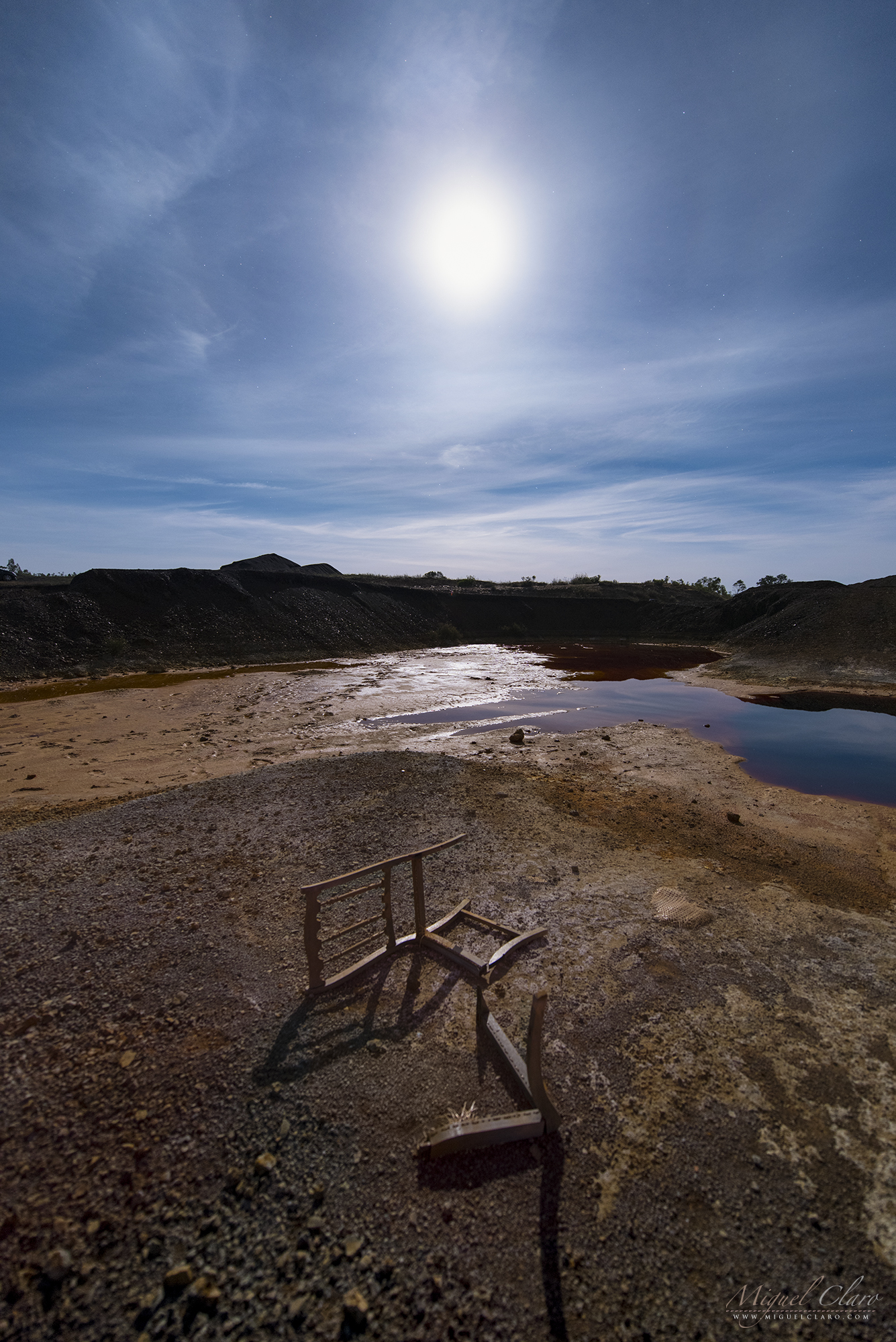
Shadows from a fragmented chair illuminated by the light of a smooth Lunar Halo above a puddle of acid water from Achada do Gamo, that was – since the beginning of modern mining activities in the São Domingos Mine – the center of metallurgical activities on extracted minerals. The areas of heaps, slag and channels of water, give the landscape a “lunar” aspect. The heaps are composed of different materials with high levels of metals, such as slag and ash, whose leaching through the rainwater leads to the production of acid mine drainage, usually with an ocher or reddish color.
São Domingos Mine is located in Baixo Alentejo, about 240 km from Lisbon, in the municipality of Mértola, which recently joined the Dark Sky® Alqueva Route for the great quality of the night sky. The São Domingos mining area is part of the Iberian Pyrite Range and is a decisive source of basic metals (S, Zn, Pb, Sn, Ag, Au, Fe, Co, Cd, etc.) and other elements such as sulfur (S). It has been a sought after place for the extraction of ores since antiquity, with evidence of gold, silver and copper mining in the pre-Roman and Roman times. The pyritic deposit of São Domingos (St. Dominic) was explored in various historical periods, namely: for several centuries of the first millennium BC (Eastern period), during the period between 14 BC and 395 AD (Roman period), during the Islamic period and during the modern period that was initiated in 1858 for the extraction of copper, gold and silver and was maintained until 1966, the year in which the reserves were considered exhausted. During this period, the work was done in the open air up to 120 meters deep, with work continued through wells and galleries up to 400 meters. Over 108 years of regular exploration, more than 20 million tons of materials were removed from the site, producing about 14.7 million tons of waste accumulated in heaps up to 14 meters high with a dozen different materials such as pyrite , gossan, slag, ash, iron oxides, barren rock, sludge, debris, etc.|
PT: Sombras de uma cadeira fragmentada iluminada pela luz de um quase imperceptível Halo lunar, que se formava acima da paisagem ácida de Achada do Gamo, que foi desde o início das atividades modernas de mineração na Mina de São Domingos, o centro das atividades metalúrgicas sobre os minérios extraídos. As áreas de escombreiras, escórias e canais de água, dão à paisagem um aspecto “lunar”. As escombreiras são constituídas por diferentes materiais com teores elevados em metais, como escórias e cinzas, cuja lixiviação através das águas das chuvas leva à produção de águas ácidas (‘acid mine drainage’), geralmente com uma cor ocre ou avermelhada.
A Mina de São Domingos, situa-se no Baixo Alentejo, a cerca de 240 km de Lisboa, no concelho de Mértola, que passou a integrar recentemente a Rota Dark Sky® Alqueva pela grande qualidade do seu céu escuro. A área mineira de São Domingos, está inserida na Faixa Piritosa Ibérica e constitui uma fonte decisiva de metais básicos (Cu, Zn, Pb, Sn, Ag, Au, Fe, Co, Cd, etc.) e de outros elementos como o enxofre (S). Foi desde a Antiguidade um local procurado para a extracção de minérios, existindo indícios de trabalhos de extracção de ouro, prata e cobre no período pré-romano e romano. O depósito pirítico de São Domingos foi explorado em diversos períodos históricos, nomeadamente: durante vários séculos do primeiro milénio a.C. (período Oriental), durante o período que mediou entre o ano 14 a.C. e o ano de 395 d.C. (período romano), durante o período islâmico e durante o período moderno que se iniciou em 1858 para a extracção de cobre, ouro e prata e manteve-se até 1966, ano em que as reservas foram consideradas esgotadas. Neste período, a lavra foi feita a céu aberto até aos 120 metros de profundidade, tendo os trabalhos continuado por meio de poços e galerias até aos 400 metros. Ao longo de 108 anos de exploração regular, foram retirados do local mais de 20 milhões de toneladas de materiais, tendo produzido cerca 14,7 milhões de toneladas de resíduos acumulados em escombreiras de até 14 metros de altura, com uma dezena de materiais diferentes como pirite, gossan, escórias, cinzas, óxidos de ferro, rocha estéril, lamas, entulhos, etc.
Moonlight and Jupiter Shinning above Corta da Mina Landscape

A Moonlight scene in a cloudy sky with bright planet Jupiter shinning above Corta da Mina landscape, that is the result of the open-pit mining operation begun in 1867 in São Domingos Mine. It has a geometrical shape of an ellipse and a depth of 120 m and a perimeter of approximately 2 km. It was the place from which the ores were extracted: the pyrites, sulfur, copper, iron, zinc, gold and silver. Around the cavity it is possible to observe several types of heaps constituted by diverse materials such as modern slag of black color, brownish Roman slag, gossan fragments of reddish color and encasing mineralization rocks like vulcanites and schists. Some of these commons have significant gold contents assuming the presence of iMt from heaps with 1g / t gold. ” After the end of the work, in 1966, the abandonment of the extraction of water from the bottom of the mine allowed the rise groundwater level within the cut to the current, apparently stationary point. The water currently contained in the cut is extremely acidic (Ph = 2) giving the water an incredible color variation with colours ranging from reddish tones to oranges and yellows, it contains a large amount of dissolved sulfates, mainly iron and arsenic sulfates, but also copper and zinc.
São Domingos Mine is located in Baixo Alentejo, about 240 km from Lisbon, in the municipality of Mértola, which recently joined the Dark Sky® Alqueva Route for the great quality of the night sky. The São Domingos mining area is part of the Iberian Pyrite Range and is a decisive source of basic metals (S, Zn, Pb, Sn, Ag, Au, Fe, Co, Cd, etc.) and other elements such as sulfur (S). It has been a sought after place for the extraction of ores since antiquity, with evidence of gold, silver and copper mining in the pre-Roman and Roman times. The pyritic deposit of São Domingos (St. Dominic) was explored in various historical periods, namely: for several centuries of the first millennium BC (Eastern period), during the period between 14 BC and 395 AD (Roman period), during the Islamic period and during the modern period that was initiated in 1858 for the extraction of copper, gold and silver and was maintained until 1966, the year in which the reserves were considered exhausted. During this period, the work was done in the open air up to 120 meters deep, with work continued through wells and galleries up to 400 meters. Over 108 years of regular exploration, more than 20 million tons of materials were removed from the site, producing about 14.7 million tons of waste accumulated in heaps up to 14 meters high with a dozen different materials such as pyrite , gossan, slag, ash, iron oxides, barren rock, sludge, debris, etc. The areas of heaps, slag and channels of water, give the landscape a “lunar” aspect. The heaps are composed of different materials with high levels of metals, such as slag and ash, whose leaching through the rainwater leads to the production of acid mine drainage, usually with an ocher or reddish color. |
PT: Um cenário ao Luar com a presença do planeta Jupiter a brilhar por detrás de um céu nublado que se precipita acima da paisagem acida da Corta da Mina, o resultado da exploração mineira a céu aberto encetada em 1867 na Mina de São Domingos, em Mértola. Possui uma forma geométrica de uma elipse e uma profundidade de 120 m e um perímetro de aproximadamente 2 km. Era o local de onde se extraíam os minérios: as pirites, enxofre, cobre, ferro, zinco, ouro e prata. Em torno da cavidade é possível observar vários tipos de escombreiras constituídas por materiais diversos como escórias modernas de cor negra, escórias romanas acastanhadas, fragmentos de gossan de cor avermelhada e rochas encaixantes da mineralização como vulcanitos e xistos. Alguns destes corpos de encombros apresentam teores significativos de ouro admitindo-se a presença de iMt de escombreiras com 1g/t de ouro.” Após o fim da laboração, em 1966, o abandono da extração de água do fundo da mina permitiu a subida do nível freático dentro da corta até ao ponto atual, aparentemente estacionário.
A água hoje contida na corta é extremamente ácida (Ph=2) conferindo à água uma variação cromática incrível com cores que vão desde tons avermelhados, a laranjas e amarelos, contém uma grande quantidade de sulfatos dissolvidos, principalmente sulfatos de ferro e arsénico mas também de cobre e zinco
A Mina de São Domingos, situa-se no Baixo Alentejo, a cerca de 240 km de Lisboa, no concelho de Mértola, que passou a integrar recentemente a Rota Dark Sky® Alqueva pela grande qualidade do seu céu escuro. A área mineira de São Domingos, está inserida na Faixa Piritosa Ibérica e constitui uma fonte decisiva de metais básicos (Cu, Zn, Pb, Sn, Ag, Au, Fe, Co, Cd, etc.) e de outros elementos como o enxofre (S). Foi desde a Antiguidade um local procurado para a extracção de minérios, existindo indícios de trabalhos de extracção de ouro, prata e cobre no período pré-romano e romano. O depósito pirítico de São Domingos foi explorado em diversos períodos históricos, nomeadamente: durante vários séculos do primeiro milénio a.C. (período Oriental), durante o período que mediou entre o ano 14 a.C. e o ano de 395 d.C. (período romano), durante o período islâmico e durante o período moderno que se iniciou em 1858 para a extracção de cobre, ouro e prata e manteve-se até 1966, ano em que as reservas foram consideradas esgotadas. Neste período, a lavra foi feita a céu aberto até aos 120 metros de profundidade, tendo os trabalhos continuado por meio de poços e galerias até aos 400 metros. Ao longo de 108 anos de exploração regular, foram retirados do local mais de 20 milhões de toneladas de materiais, tendo produzido cerca 14,7 milhões de toneladas de resíduos acumulados em escombreiras de até 14 metros de altura, com uma dezena de materiais diferentes como pirite, gossan, escórias, cinzas, óxidos de ferro, rocha estéril, lamas, entulhos, etc. As áreas de escombreiras, escórias e canais de água, dão à paisagem um aspecto “lunar”. As escombreiras são constituídas por diferentes materiais com teores elevados em metais, como escórias e cinzas, cuja lixiviação através das águas das chuvas leva à produção de águas ácidas (‘acid mine drainage’), geralmente com uma cor ocre ou avermelhada.
Full Moon Emerging from an Acid Landscape

A Full Moon is reflected in a puddle of acid water from Achada do Gamo, that was – since the beginning of modern mining activities in the São Domingos Mine – the center of metallurgical activities on extracted minerals. The areas of heaps, slag and channels of water, give the landscape a “lunar” aspect, revealed in this image naturally illuminated by the Moonlight. The heaps are composed of different materials with high levels of metals, such as slag and ash, whose leaching through the rainwater leads to the production of acid mine drainage, usually with an ocher or reddish color.
São Domingos Mine is located in Baixo Alentejo, about 240 km from Lisbon, in the municipality of Mértola, which recently joined the Dark Sky® Alqueva Route for the great quality of the night sky. The São Domingos mining area is part of the Iberian Pyrite Range and is a decisive source of basic metals (S, Zn, Pb, Sn, Ag, Au, Fe, Co, Cd, etc.) and other elements such as sulfur (S). It has been a sought after place for the extraction of ores since antiquity, with evidence of gold, silver and copper mining in the pre-Roman and Roman times. The pyritic deposit of São Domingos (St. Dominic) was explored in various historical periods, namely: for several centuries of the first millennium BC (Eastern period), during the period between 14 BC and 395 AD (Roman period), during the Islamic period and during the modern period that was initiated in 1858 for the extraction of copper, gold and silver and was maintained until 1966, the year in which the reserves were considered exhausted. During this period, the work was done in the open air up to 120 meters deep, with work continued through wells and galleries up to 400 meters. Over 108 years of regular exploration, more than 20 million tons of materials were removed from the site, producing about 14.7 million tons of waste accumulated in heaps up to 14 meters high with a dozen different materials such as pyrite , gossan, slag, ash, iron oxides, barren rock, sludge, debris, etc.|
PT: A Lua Cheia reflectida nas águas ácidas da Achada do Gamo, que foi desde o início das atividades modernas de mineração na Mina de São Domingos, o centro das atividades metalúrgicas sobre os minérios extraídos. As áreas de escombreiras, escórias e canais de água, dão à paisagem um aspecto “lunar”, revelado nesta imagem nocturna pela luz natural do luar. As escombreiras são constituídas por diferentes materiais com teores elevados em metais, como escórias e cinzas, cuja lixiviação através das águas das chuvas leva à produção de águas ácidas (‘acid mine drainage’), geralmente com uma cor ocre ou avermelhada.
A Mina de São Domingos, situa-se no Baixo Alentejo, a cerca de 240 km de Lisboa, no concelho de Mértola, que passou a integrar recentemente a Rota Dark Sky® Alqueva pela grande qualidade do seu céu escuro. A área mineira de São Domingos, está inserida na Faixa Piritosa Ibérica e constitui uma fonte decisiva de metais básicos (Cu, Zn, Pb, Sn, Ag, Au, Fe, Co, Cd, etc.) e de outros elementos como o enxofre (S). Foi desde a Antiguidade um local procurado para a extracção de minérios, existindo indícios de trabalhos de extracção de ouro, prata e cobre no período pré-romano e romano. O depósito pirítico de São Domingos foi explorado em diversos períodos históricos, nomeadamente: durante vários séculos do primeiro milénio a.C. (período Oriental), durante o período que mediou entre o ano 14 a.C. e o ano de 395 d.C. (período romano), durante o período islâmico e durante o período moderno que se iniciou em 1858 para a extracção de cobre, ouro e prata e manteve-se até 1966, ano em que as reservas foram consideradas esgotadas. Neste período, a lavra foi feita a céu aberto até aos 120 metros de profundidade, tendo os trabalhos continuado por meio de poços e galerias até aos 400 metros. Ao longo de 108 anos de exploração regular, foram retirados do local mais de 20 milhões de toneladas de materiais, tendo produzido cerca 14,7 milhões de toneladas de resíduos acumulados em escombreiras de até 14 metros de altura, com uma dezena de materiais diferentes como pirite, gossan, escórias, cinzas, óxidos de ferro, rocha estéril, lamas, entulhos, etc.
A Lunar Landscape shows a Full Moon Reflected in the Acid Water of Mina de São Domingos

A Full Moon is reflected in a puddle of acid water from Achada do Gamo, that was – since the beginning of modern mining activities in the São Domingos Mine – the center of metallurgical activities on extracted minerals. The areas of heaps, slag and channels of water, give the landscape a “lunar” aspect. The heaps are composed of different materials with high levels of metals, such as slag and ash, whose leaching through the rainwater leads to the production of acid mine drainage, usually with an ocher or reddish color.
São Domingos Mine is located in Baixo Alentejo, about 240 km from Lisbon, in the municipality of Mértola, which recently joined the Dark Sky® Alqueva Route for the great quality of the night sky. The São Domingos mining area is part of the Iberian Pyrite Range and is a decisive source of basic metals (S, Zn, Pb, Sn, Ag, Au, Fe, Co, Cd, etc.) and other elements such as sulfur (S). It has been a sought after place for the extraction of ores since antiquity, with evidence of gold, silver and copper mining in the pre-Roman and Roman times. The pyritic deposit of São Domingos (St. Dominic) was explored in various historical periods, namely: for several centuries of the first millennium BC (Eastern period), during the period between 14 BC and 395 AD (Roman period), during the Islamic period and during the modern period that was initiated in 1858 for the extraction of copper, gold and silver and was maintained until 1966, the year in which the reserves were considered exhausted. During this period, the work was done in the open air up to 120 meters deep, with work continued through wells and galleries up to 400 meters. Over 108 years of regular exploration, more than 20 million tons of materials were removed from the site, producing about 14.7 million tons of waste accumulated in heaps up to 14 meters high with a dozen different materials such as pyrite , gossan, slag, ash, iron oxides, barren rock, sludge, debris, etc.|
PT: A Lua Cheia reflectida nas águas ácidas da Achada do Gamo, que foi desde o início das atividades modernas de mineração na Mina de São Domingos, o centro das atividades metalúrgicas sobre os minérios extraídos. As áreas de escombreiras, escórias e canais de água, dão à paisagem um aspecto “lunar”. As escombreiras são constituídas por diferentes materiais com teores elevados em metais, como escórias e cinzas, cuja lixiviação através das águas das chuvas leva à produção de águas ácidas (‘acid mine drainage’), geralmente com uma cor ocre ou avermelhada.
A Mina de São Domingos, situa-se no Baixo Alentejo, a cerca de 240 km de Lisboa, no concelho de Mértola, que passou a integrar recentemente a Rota Dark Sky® Alqueva pela grande qualidade do seu céu escuro. A área mineira de São Domingos, está inserida na Faixa Piritosa Ibérica e constitui uma fonte decisiva de metais básicos (Cu, Zn, Pb, Sn, Ag, Au, Fe, Co, Cd, etc.) e de outros elementos como o enxofre (S). Foi desde a Antiguidade um local procurado para a extracção de minérios, existindo indícios de trabalhos de extracção de ouro, prata e cobre no período pré-romano e romano. O depósito pirítico de São Domingos foi explorado em diversos períodos históricos, nomeadamente: durante vários séculos do primeiro milénio a.C. (período Oriental), durante o período que mediou entre o ano 14 a.C. e o ano de 395 d.C. (período romano), durante o período islâmico e durante o período moderno que se iniciou em 1858 para a extracção de cobre, ouro e prata e manteve-se até 1966, ano em que as reservas foram consideradas esgotadas. Neste período, a lavra foi feita a céu aberto até aos 120 metros de profundidade, tendo os trabalhos continuado por meio de poços e galerias até aos 400 metros. Ao longo de 108 anos de exploração regular, foram retirados do local mais de 20 milhões de toneladas de materiais, tendo produzido cerca 14,7 milhões de toneladas de resíduos acumulados em escombreiras de até 14 metros de altura, com uma dezena de materiais diferentes como pirite, gossan, escórias, cinzas, óxidos de ferro, rocha estéril, lamas, entulhos, etc.
Moonrise Behind a Metallurgic Structure from Achada do Gamo

The Full Moon is rising against the silhouette structure from Achada do Gamo, that was – since the beginning of modern mining activities in the São Domingos Mine – the center of metallurgical activities on extracted minerals. Already during the 20th century, between the 30s and 40s, a new direction of industrial exploration took place: the sulfur, however much valued, began to be extracted from the copper pyrites through furnaces (Orkla process) in two plants installed in the Achada do Gamo during the years of 1934 and 1943.
São Domingos Mine is located in Baixo Alentejo, about 240 km from Lisbon, in the municipality of Mértola, which recently joined the Dark Sky® Alqueva Route for the great quality of the night sky. The São Domingos mining area is part of the Iberian Pyrite Range and is a decisive source of basic metals (S, Zn, Pb, Sn, Ag, Au, Fe, Co, Cd, etc.) and other elements such as sulfur (S). It has been a sought after place for the extraction of ores since antiquity, with evidence of gold, silver and copper mining in the pre-Roman and Roman times. The pyritic deposit of São Domingos (St. Dominic) was explored in various historical periods, namely: for several centuries of the first millennium BC (Eastern period), during the period between 14 BC and 395 AD (Roman period), during the Islamic period and during the modern period that was initiated in 1858 for the extraction of copper, gold and silver and was maintained until 1966, the year in which the reserves were considered exhausted. During this period, the work was done in the open air up to 120 meters deep, with work continued through wells and galleries up to 400 meters. Over 108 years of regular exploration, more than 20 million tons of materials were removed from the site, producing about 14.7 million tons of waste accumulated in heaps up to 14 meters high with a dozen different materials such as pyrite , gossan, slag, ash, iron oxides, barren rock, sludge, debris, etc. The areas of heaps, slag and channels of water, give the landscape a “lunar” aspect. The heaps are composed of different materials with high levels of metals, such as slag and ash, whose leaching through the rainwater leads to the production of acid mine drainage, usually with an ocher or reddish color. |
PT: A Lua Cheia nasce por detrás da silhueta da estrutura metalúrgica da Achada do Gamo, que foi desde o início das atividades modernas de mineração na Mina de São Domingos, o centro das atividades metalúrgicas sobre os minérios extraídos. Já durante o século XX, entre as décadas de 30 e 40, uma nova direção de exploração industrial tomou lugar: o enxofre, entretanto muito valorizado, passou a ser extraído das pirites cupríferas através de fornos (processo Orkla) em duas unidades fabris instaladas na Achada do Gamo durante os anos de 1934 e 1943.
A Mina de São Domingos, situa-se no Baixo Alentejo, a cerca de 240 km de Lisboa, no concelho de Mértola, que passou a integrar recentemente a Rota Dark Sky® Alqueva pela grande qualidade do seu céu escuro. A área mineira de São Domingos, está inserida na Faixa Piritosa Ibérica e constitui uma fonte decisiva de metais básicos (Cu, Zn, Pb, Sn, Ag, Au, Fe, Co, Cd, etc.) e de outros elementos como o enxofre (S). Foi desde a Antiguidade um local procurado para a extracção de minérios, existindo indícios de trabalhos de extracção de ouro, prata e cobre no período pré-romano e romano. O depósito pirítico de São Domingos foi explorado em diversos períodos históricos, nomeadamente: durante vários séculos do primeiro milénio a.C. (período Oriental), durante o período que mediou entre o ano 14 a.C. e o ano de 395 d.C. (período romano), durante o período islâmico e durante o período moderno que se iniciou em 1858 para a extracção de cobre, ouro e prata e manteve-se até 1966, ano em que as reservas foram consideradas esgotadas. Neste período, a lavra foi feita a céu aberto até aos 120 metros de profundidade, tendo os trabalhos continuado por meio de poços e galerias até aos 400 metros. Ao longo de 108 anos de exploração regular, foram retirados do local mais de 20 milhões de toneladas de materiais, tendo produzido cerca 14,7 milhões de toneladas de resíduos acumulados em escombreiras de até 14 metros de altura, com uma dezena de materiais diferentes como pirite, gossan, escórias, cinzas, óxidos de ferro, rocha estéril, lamas, entulhos, etc. As áreas de escombreiras, escórias e canais de água, dão à paisagem um aspecto “lunar”. As escombreiras são constituídas por diferentes materiais com teores elevados em metais, como escórias e cinzas, cuja lixiviação através das águas das chuvas leva à produção de águas ácidas (‘acid mine drainage’), geralmente com uma cor ocre ou avermelhada.
Full Moon Behind a Metallurgic Silhouette from Achada do Gamo

The Full Moon is rising against the silhouette structure from Achada do Gamo, that was – since the beginning of modern mining activities in the São Domingos Mine – the center of metallurgical activities on extracted minerals. Already during the 20th century, between the 30s and 40s, a new direction of industrial exploration took place: the sulfur, however much valued, began to be extracted from the copper pyrites through furnaces (Orkla process) in two plants installed in the Achada do Gamo during the years of 1934 and 1943.
São Domingos Mine is located in Baixo Alentejo, about 240 km from Lisbon, in the municipality of Mértola, which recently joined the Dark Sky® Alqueva Route for the great quality of the night sky. The São Domingos mining area is part of the Iberian Pyrite Range and is a decisive source of basic metals (S, Zn, Pb, Sn, Ag, Au, Fe, Co, Cd, etc.) and other elements such as sulfur (S). It has been a sought after place for the extraction of ores since antiquity, with evidence of gold, silver and copper mining in the pre-Roman and Roman times. The pyritic deposit of São Domingos (St. Dominic) was explored in various historical periods, namely: for several centuries of the first millennium BC (Eastern period), during the period between 14 BC and 395 AD (Roman period), during the Islamic period and during the modern period that was initiated in 1858 for the extraction of copper, gold and silver and was maintained until 1966, the year in which the reserves were considered exhausted. During this period, the work was done in the open air up to 120 meters deep, with work continued through wells and galleries up to 400 meters. Over 108 years of regular exploration, more than 20 million tons of materials were removed from the site, producing about 14.7 million tons of waste accumulated in heaps up to 14 meters high with a dozen different materials such as pyrite , gossan, slag, ash, iron oxides, barren rock, sludge, debris, etc. The areas of heaps, slag and channels of water, give the landscape a “lunar” aspect. The heaps are composed of different materials with high levels of metals, such as slag and ash, whose leaching through the rainwater leads to the production of acid mine drainage, usually with an ocher or reddish color. |
PT: A Lua Cheia nasce por detrás da silhueta da estrutura metalúrgica da Achada do Gamo, que foi desde o início das atividades modernas de mineração na Mina de São Domingos, o centro das atividades metalúrgicas sobre os minérios extraídos. Já durante o século XX, entre as décadas de 30 e 40, uma nova direção de exploração industrial tomou lugar: o enxofre, entretanto muito valorizado, passou a ser extraído das pirites cupríferas através de fornos (processo Orkla) em duas unidades fabris instaladas na Achada do Gamo durante os anos de 1934 e 1943.
A Mina de São Domingos, situa-se no Baixo Alentejo, a cerca de 240 km de Lisboa, no concelho de Mértola, que passou a integrar recentemente a Rota Dark Sky® Alqueva pela grande qualidade do seu céu escuro. A área mineira de São Domingos, está inserida na Faixa Piritosa Ibérica e constitui uma fonte decisiva de metais básicos (Cu, Zn, Pb, Sn, Ag, Au, Fe, Co, Cd, etc.) e de outros elementos como o enxofre (S). Foi desde a Antiguidade um local procurado para a extracção de minérios, existindo indícios de trabalhos de extracção de ouro, prata e cobre no período pré-romano e romano. O depósito pirítico de São Domingos foi explorado em diversos períodos históricos, nomeadamente: durante vários séculos do primeiro milénio a.C. (período Oriental), durante o período que mediou entre o ano 14 a.C. e o ano de 395 d.C. (período romano), durante o período islâmico e durante o período moderno que se iniciou em 1858 para a extracção de cobre, ouro e prata e manteve-se até 1966, ano em que as reservas foram consideradas esgotadas. Neste período, a lavra foi feita a céu aberto até aos 120 metros de profundidade, tendo os trabalhos continuado por meio de poços e galerias até aos 400 metros. Ao longo de 108 anos de exploração regular, foram retirados do local mais de 20 milhões de toneladas de materiais, tendo produzido cerca 14,7 milhões de toneladas de resíduos acumulados em escombreiras de até 14 metros de altura, com uma dezena de materiais diferentes como pirite, gossan, escórias, cinzas, óxidos de ferro, rocha estéril, lamas, entulhos, etc. As áreas de escombreiras, escórias e canais de água, dão à paisagem um aspecto “lunar”. As escombreiras são constituídas por diferentes materiais com teores elevados em metais, como escórias e cinzas, cuja lixiviação através das águas das chuvas leva à produção de águas ácidas (‘acid mine drainage’), geralmente com uma cor ocre ou avermelhada.
A Twilight of a Double Moonrise above Mina de São Domingos

A twilight of a “double” moonrise reflected in a puddle of acid water from Achada do Gamo, that was – since the beginning of modern mining activities in the São Domingos Mine – the center of metallurgical activities on extracted minerals. Already during the 20th century, between the 30s and 40s, a new direction of industrial exploration took place: the sulfur, however much valued, began to be extracted from the copper pyrites through furnaces (Orkla process) in two plants installed in the Achada do Gamo during the years of 1934 and 1943.
São Domingos Mine is located in Baixo Alentejo, about 240 km from Lisbon, in the municipality of Mértola, which recently joined the Dark Sky® Alqueva Route for the great quality of the night sky. The São Domingos mining area is part of the Iberian Pyrite Range and is a decisive source of basic metals (S, Zn, Pb, Sn, Ag, Au, Fe, Co, Cd, etc.) and other elements such as sulfur (S). It has been a sought after place for the extraction of ores since antiquity, with evidence of gold, silver and copper mining in the pre-Roman and Roman times. The pyritic deposit of São Domingos (St. Dominic) was explored in various historical periods, namely: for several centuries of the first millennium BC (Eastern period), during the period between 14 BC and 395 AD (Roman period), during the Islamic period and during the modern period that was initiated in 1858 for the extraction of copper, gold and silver and was maintained until 1966, the year in which the reserves were considered exhausted. During this period, the work was done in the open air up to 120 meters deep, with work continued through wells and galleries up to 400 meters. Over 108 years of regular exploration, more than 20 million tons of materials were removed from the site, producing about 14.7 million tons of waste accumulated in heaps up to 14 meters high with a dozen different materials such as pyrite , gossan, slag, ash, iron oxides, barren rock, sludge, debris, etc. The areas of heaps, slag and channels of water, give the landscape a “lunar” aspect. The heaps are composed of different materials with high levels of metals, such as slag and ash, whose leaching through the rainwater leads to the production of acid mine drainage, usually with an ocher or reddish color.|
PT: Durante o crepúsculo uma “lua dupla” nasce reflectida nas águas ácidas da Achada do Gamo, que foi desde o início das atividades modernas de mineração na Mina de São Domingos, o centro das atividades metalúrgicas sobre os minérios extraídos. Já durante o século XX, entre as décadas de 30 e 40, uma nova direção de exploração industrial tomou lugar: o enxofre, entretanto muito valorizado, passou a ser extraído das pirites cupríferas através de fornos (processo Orkla) em duas unidades fabris instaladas na Achada do Gamo durante os anos de 1934 e 1943.
A Mina de São Domingos, situa-se no Baixo Alentejo, a cerca de 240 km de Lisboa, no concelho de Mértola, que passou a integrar recentemente a Rota Dark Sky® Alqueva pela grande qualidade do seu céu escuro. A área mineira de São Domingos, está inserida na Faixa Piritosa Ibérica e constitui uma fonte decisiva de metais básicos (Cu, Zn, Pb, Sn, Ag, Au, Fe, Co, Cd, etc.) e de outros elementos como o enxofre (S). Foi desde a Antiguidade um local procurado para a extracção de minérios, existindo indícios de trabalhos de extracção de ouro, prata e cobre no período pré-romano e romano. O depósito pirítico de São Domingos foi explorado em diversos períodos históricos, nomeadamente: durante vários séculos do primeiro milénio a.C. (período Oriental), durante o período que mediou entre o ano 14 a.C. e o ano de 395 d.C. (período romano), durante o período islâmico e durante o período moderno que se iniciou em 1858 para a extracção de cobre, ouro e prata e manteve-se até 1966, ano em que as reservas foram consideradas esgotadas. Neste período, a lavra foi feita a céu aberto até aos 120 metros de profundidade, tendo os trabalhos continuado por meio de poços e galerias até aos 400 metros. Ao longo de 108 anos de exploração regular, foram retirados do local mais de 20 milhões de toneladas de materiais, tendo produzido cerca 14,7 milhões de toneladas de resíduos acumulados em escombreiras de até 14 metros de altura, com uma dezena de materiais diferentes como pirite, gossan, escórias, cinzas, óxidos de ferro, rocha estéril, lamas, entulhos, etc. As áreas de escombreiras, escórias e canais de água, dão à paisagem um aspecto “lunar”. As escombreiras são constituídas por diferentes materiais com teores elevados em metais, como escórias e cinzas, cuja lixiviação através das águas das chuvas leva à produção de águas ácidas (‘acid mine drainage’), geralmente com uma cor ocre ou avermelhada.


