
Peacock Sleeping on a Tree Under a Colorful Lunar Corona Lit by a Super Blue Moon

The image shows a peacock sleeping in a tree in Punta Cana, Dominican Republic, in a special night on 20th August 2024, when the second full Moon of the Month happened, and for being as well at perigee was also called a Super Blue Moon. The single shot, also shows the background sky with high clouds covering the unfocused moon, while revealing the iridescence of a colorful corona surrounding our natural satellite. I was surprised to see a tree full of peacocks, I din’t knew that they were sleeping on trees to protect themselves from predators. Even not being well visible on the image, the peacock had by its side one little offspring, which I only noticed by the end of my capture. NatGeo explains that the term “peacock” is commonly used to refer to birds of both sexes. Technically, only males are peacocks. Females are peahens, and together, they are called peafowl. Peacocks are large, colorful pheasants (typically blue and green) known for their iridescent tails.The two Asiatic species are the blue or Indian peafowl originally from the Indian subcontinent, and the green peafowl from Southeast Asia. According to wikipedia, the Ancient Greeks believed that the flesh of peafowl did not decay after death, so it became a symbol of immortality. In Hellenistic imagery, the Greek goddess Hera’s chariot was pulled by peacocks, birds not known to Greeks before the conquests of Alexander. Alexander’s tutor, Aristotle, refers to it as “the Persian bird”. When Alexander saw the birds in India, he was so amazed at their beauty that he threatened the severest penalties for any man who slew one. Claudius Aelianus writes that there were peacocks in India, larger than anywhere else. In Christianity, the peacock can also symbolise the cosmos if one interprets its tail with its many “eyes” as the vault of heaven dotted by the sun, moon, and stars. Due to the adoption by Augustine of the ancient idea that the peacock’s flesh did not decay, the bird was again associated with immortality.
PT: A imagem mostra um pavão a dormir numa árvore em Punta Cana, República Dominicana, numa noite especial de 20 de agosto de 2024, quando ocorreu a segunda Lua Cheia do mês, e por estar também no perigeu foi também chamada de Super Lua Azul. A imagem de disparo único, mostra também o céu em pano de fundo com nuvens altas a cobrir a lua desfocada, enquanto revela a iridescência de uma coroa lunar visivíel em torno do nosso satélite natural. Fiquei surpreendido ao ver uma árvore cheia de pavões, não sabia que dormiam nas árvores para se protegerem dos predadores. Embora não seja claramente visível, este pavão tinha ainda a sua cria ao lado. So no final da captação de imagens é que me apercebi da sua pequena companhia. A NatGeo explica que o termo “pavão” é commumente utilizado para se referir a aves de ambos os sexos. Tecnicamente, só os machos são pavões. As fêmeas são pavoas e, em conjunto, são chamadas de pavões. Os pavões são faisões grandes e coloridos (normalmente azuis e verdes), conhecidos pelas suas caudas iridescentes. As duas espécies asiáticas são o pavão azul ou Indiano, originário do subcontinente Indiano, e o pavão verde, do Sudeste Asiático. Segundo a Wikipédia, na antiga grécia acreditava-se que a carne do pavão não se decompunha após a morte, pelo que se tornou um símbolo da imortalidade. Nas imagens helenísticas, o carro da deusa grega Hera era puxado por pavões, aves desconhecidas pelos gregos antes das conquistas de Alexandre. O tutor de Alexandre, Aristóteles, refere-se a ele como “o pássaro persa”. Quando Alexandre viu os pássaros na Índia, ficou tão impressionado com a sua beleza que ameaçou com as mais severas penas a qualquer homem que matasse um deles. Cláudio Aelianus escreve que existiam pavões na Índia, maiores do que em qualquer outro lugar. No Cristianismo, o pavão pode também simbolizar o Cosmos se interpretarmos a sua cauda com os seus muitos “olhos” como a abóbada celeste pontilhada pelo sol, pela lua e pelas estrelas. Devido à adoção por Agostinho da antiga ideia de que a carne do pavão não se decompunha, a ave foi novamente associada à imortalidade.

BUY THIS PRINT | COMPRAR ESTA IMPRESSÃO
Buy a Fine Art Print or Wall Decor of this Image – Make your order Now!
You can choose the best style of print do you preffer to decorate in a fashion way your walls. Metal Prints with durable and vivid colors, Acrylic, Canvas or the highest quality Gallery Print – a 6 colour UV direct printing on acrylic glass (2mm) including light colours and reinforced by an aluminium dibond plate (3mm). Those type of Prints can highlight the final work in an artistic way, showing the photograph as a piece of art. I work with two high quality specialized Labs in US and in Europe, using Kodak Professional Endura Premier Metallic papers and Fujifilm Crystal Archive DP II Professional. You can select the image above or freely navigate to more than 800 photographs available in my gallery – each one with their own story and magic – and choose the photograph you would love to have in your home or office.
How to Order – Simple and easy, just “copy and paste” the link of this page or the image you choosed and fill it in the form below, with the size you want and any detail you wish to include on the message, like your country, name and postal address. Free Shipping included to all prints (except frames). For US and Europe the delivery is 4-8 working days, while to Portugal and Spain is normally 2-6 working days. After submitting the order through the form, I will contact you for the payment method (Paypal available or bank transfer) and with other questions related to your print(s) or requests. Once payment is confirmed, your order is shipped within 24h. In case you wish, I can send you separtely with no additional cost, a postcard autographed and numbered of the same image you have just bought, as a seal and proof of art work authenticity from the author. Let me know what is your wish.
Peacock Sleeping on a Tree Under the Super Blue Moonlight

The image shows a peacock sleeping in a tree in Punta Cana, Dominican Republic, in a special night on 20th August 2024, when the second full Moon of the Month happened, and for being as well at perigee was also called a Super Blue Moon. The single shot, also shows the background sky with high clouds covering the unfocused moon. I was surprised to see a tree full of peacocks, I din’t knew that they were sleeping on trees to protect themselves from predators. Even not being well visible on the image, the peacock had by its side one little offspring, which I only noticed by the end of my capture. NatGeo explains that the term “peacock” is commonly used to refer to birds of both sexes. Technically, only males are peacocks. Females are peahens, and together, they are called peafowl. Peacocks are large, colorful pheasants (typically blue and green) known for their iridescent tails.The two Asiatic species are the blue or Indian peafowl originally from the Indian subcontinent, and the green peafowl from Southeast Asia. According to wikipedia, the Ancient Greeks believed that the flesh of peafowl did not decay after death, so it became a symbol of immortality. In Hellenistic imagery, the Greek goddess Hera’s chariot was pulled by peacocks, birds not known to Greeks before the conquests of Alexander. Alexander’s tutor, Aristotle, refers to it as “the Persian bird”. When Alexander saw the birds in India, he was so amazed at their beauty that he threatened the severest penalties for any man who slew one. Claudius Aelianus writes that there were peacocks in India, larger than anywhere else. In Christianity, the peacock can also symbolise the cosmos if one interprets its tail with its many “eyes” as the vault of heaven dotted by the sun, moon, and stars. Due to the adoption by Augustine of the ancient idea that the peacock’s flesh did not decay, the bird was again associated with immortality.
PT: A imagem mostra um pavão a dormir numa árvore em Punta Cana, República Dominicana, numa noite especial de 20 de agosto de 2024, quando ocorreu a segunda Lua Cheia do mês, e por estar também no perigeu foi também chamada de Super Lua Azul. A imagem de disparo único, mostra também o céu de fundo com nuvens altas a cobrir a lua desfocada. Fiquei surpreendido ao ver uma árvore cheia de pavões, não sabia que dormiam nas árvores para se protegerem dos predadores. Embora não seja claramente visível, este pavão tinha ainda a sua cria ao lado. So no final da captação de imagens é que me apercebi da sua pequena companhia. A NatGeo explica que o termo “pavão” é commumente utilizado para se referir a aves de ambos os sexos. Tecnicamente, só os machos são pavões. As fêmeas são pavoas e, em conjunto, são chamadas de pavões. Os pavões são faisões grandes e coloridos (normalmente azuis e verdes), conhecidos pelas suas caudas iridescentes. As duas espécies asiáticas são o pavão azul ou Indiano, originário do subcontinente Indiano, e o pavão verde, do Sudeste Asiático. Segundo a Wikipédia, na antiga grécia acreditava-se que a carne do pavão não se decompunha após a morte, pelo que se tornou um símbolo da imortalidade. Nas imagens helenísticas, o carro da deusa grega Hera era puxado por pavões, aves desconhecidas pelos gregos antes das conquistas de Alexandre. O tutor de Alexandre, Aristóteles, refere-se a ele como “o pássaro persa”. Quando Alexandre viu os pássaros na Índia, ficou tão impressionado com a sua beleza que ameaçou com as mais severas penas a qualquer homem que matasse um deles. Cláudio Aelianus escreve que existiam pavões na Índia, maiores do que em qualquer outro lugar. No Cristianismo, o pavão pode também simbolizar o Cosmos se interpretarmos a sua cauda com os seus muitos “olhos” como a abóbada celeste pontilhada pelo sol, pela lua e pelas estrelas. Devido à adoção por Agostinho da antiga ideia de que a carne do pavão não se decompunha, a ave foi novamente associada à imortalidade.


BUY THIS PRINT | COMPRAR ESTA IMPRESSÃO
Buy a Fine Art Print or Wall Decor of this Image – Make your order Now!
You can choose the best style of print do you preffer to decorate in a fashion way your walls. Metal Prints with durable and vivid colors, Acrylic, Canvas or the highest quality Gallery Print – a 6 colour UV direct printing on acrylic glass (2mm) including light colours and reinforced by an aluminium dibond plate (3mm). Those type of Prints can highlight the final work in an artistic way, showing the photograph as a piece of art. I work with two high quality specialized Labs in US and in Europe, using Kodak Professional Endura Premier Metallic papers and Fujifilm Crystal Archive DP II Professional. You can select the image above or freely navigate to more than 800 photographs available in my gallery – each one with their own story and magic – and choose the photograph you would love to have in your home or office.
How to Order – Simple and easy, just “copy and paste” the link of this page or the image you choosed and fill it in the form below, with the size you want and any detail you wish to include on the message, like your country, name and postal address. Free Shipping included to all prints (except frames). For US and Europe the delivery is 4-8 working days, while to Portugal and Spain is normally 2-6 working days. After submitting the order through the form, I will contact you for the payment method (Paypal available or bank transfer) and with other questions related to your print(s) or requests. Once payment is confirmed, your order is shipped within 24h. In case you wish, I can send you separtely with no additional cost, a postcard autographed and numbered of the same image you have just bought, as a seal and proof of art work authenticity from the author. Let me know what is your wish.
A Stargazer Taking Care of the Bluish Brightest Star Sirius

The image features a stargazer holding the hot bluish star Sirius in his hand while the silhouette of the tree seems to hold other colorful bright stars from the winter constellations, like Orion, which dominates the background of the natural scene captured in Pampilhosa da Serra, resembling a Christmas Feeling.
PT: A imagem mostra uma observadora de estrelas amparando em sua mão a estrela azulada Sirius, enquanto a silhueta da árvore parece conter outras estrelas coloridas brilhantes das constelações de Inverno, como Orion, que domina o plano de fundo desta cena de paisagem natural, captada na Pampilhosa da Serra e que nos deixa com uma sensação de espírito natalício.
BUY THIS PRINT | COMPRAR ESTA IMPRESSÃO
Buy a Fine Art Print or Wall Decor of this Image – Make your order Now!
You can choose the best style of print do you preffer to decorate in a fashion way your walls. Metal Prints with durable and vivid colors, Acrylic, Canvas or the highest quality Gallery Print – a 6 colour UV direct printing on acrylic glass (2mm) including light colours and reinforced by an aluminium dibond plate (3mm). Those type of Prints can highlight the final work in an artistic way, showing the photograph as a piece of art. I work with two high quality specialized Labs in US and in Europe, using Kodak Professional Endura Premier Metallic papers and Fujifilm Crystal Archive DP II Professional. You can select the image above or freely navigate to more than 800 photographs available in my gallery – each one with their own story and magic – and choose the photograph you would love to have in your home or office.
How to Order – Simple and easy, just “copy and paste” the link of this page or the image you choosed and fill it in the form below, with the size you want and any detail you wish to include on the message, like your country, name and postal address. Free Shipping included to all prints (except frames). For US and Europe the delivery is 4-8 working days, while to Portugal and Spain is normally 2-6 working days. After submitting the order through the form, I will contact you for the payment method (Paypal available or bank transfer) and with other questions related to your print(s) or requests. Once payment is confirmed, your order is shipped within 24h. In case you wish, I can send you separtely with no additional cost, a postcard autographed and numbered of the same image you have just bought, as a seal and proof of art work authenticity from the author. Let me know what is your wish.
Pine Trees Touching the Sky

The image reveals a summer scene where the path of Milky Way is shinning bright in the background sky. Against it, are visible two high pine trees that seems to touch the sky above Pampilhosa da Serra.
PT: A imagem revela uma cena de verão onde o caminho da Via Láctea brilha no céu de fundo. Contra ele, são visíveis dois pinheiros altos que parecem tocar no céu sobre a Pampilhosa da Serra.
BUY THIS PRINT | COMPRAR ESTA IMPRESSÃO
Buy a Fine Art Print or Wall Decor of this Image – Make your order Now!
You can choose the best style of print do you preffer to decorate in a fashion way your walls. Metal Prints with durable and vivid colors, Acrylic, Canvas or the highest quality Gallery Print – a 6 colour UV direct printing on acrylic glass (2mm) including light colours and reinforced by an aluminium dibond plate (3mm). Those type of Prints can highlight the final work in an artistic way, showing the photograph as a piece of art. I work with two high quality specialized Labs in US and in Europe, using Kodak Professional Endura Premier Metallic papers and Fujifilm Crystal Archive DP II Professional. You can select the image above or freely navigate to more than 800 photographs available in my gallery – each one with their own story and magic – and choose the photograph you would love to have in your home or office.
How to Order – Simple and easy, just “copy and paste” the link of this page or the image you choosed and fill it in the form below, with the size you want and any detail you wish to include on the message, like your country, name and postal address. Free Shipping included to all prints (except frames). For US and Europe the delivery is 4-8 working days, while to Portugal and Spain is normally 2-6 working days. After submitting the order through the form, I will contact you for the payment method (Paypal available or bank transfer) and with other questions related to your print(s) or requests. Once payment is confirmed, your order is shipped within 24h. In case you wish, I can send you separtely with no additional cost, a postcard autographed and numbered of the same image you have just bought, as a seal and proof of art work authenticity from the author. Let me know what is your wish.
A Strong Zodiacal Light and Winter Milky Way Shines above Pampilhosa da Serra

Captured from Pampilhosa da Serra at the end of twilight, the image shows the strongest Zodiacal Light I´ve ever photographed – which could be even seen with naked eye – as a very very faint diffuse light coming from the region where planet Venus was located in the western sky. The zodiacal light is a faint light beam that extends along the ecliptic plane, where they are the constellations of the Zodiac. It is caused by the scattering of sunlight in cosmic dust particles that can be found scattered all over the Solar System. Following the faint shape which crossed almost the entire vertical panorama comprising 4 still images, and will end up on the Pleiades blueish star cluster. Above it, a beautiful winter Milky Way was arching and shining near the Zenith, featuring winter deep sky wonders like California nebula (on the top right of Pleiades) or the Heart and Soul reddish nebulosity in the right edge of the image. Below the deep sky pair, an oblong diffuse shape is also visible, belonging to our neighbour Galaxy of Andromeda. On the ground, between the mountain range of Pampilhosa, curving channels from the lake of Santa Luzia dam, are reflecting the strong light of Venus, as well as the less colorful hues from the end of nautical twilight.
PT: Captada na Pampilhosa da Serra ao final do crepúsculo, a imagem mostra a Luz Zodiacal mais forte que já tive oportunidade de fotografar até hoje e que podia ser vista a olho nu, como uma luz difusa muito fraca, proveniente da região ocidental do céu onde o planeta Vénus se encontrava. A luz Zodiacal é um feixe de luz fraca que se estende ao longo do plano da eclíptica, onde estão as constelações do zodíaco. É causada pela dispersão da luz solar nas partículas de poeira cósmica que se podem encontrar espalhadas um pouco por todo o Sistema Solar. Seguindo a emissão ténue que atravessa quase todo o panorama vertical, composto por 4 imagens estáticas, encontramos o aglomerado de estrelas jovens, quentes e azuladas, Pleaides (M45). Acima deste, uma bela Via Láctea de inverno arqueada brilhava perto Zénite, apresentando as maravilhas do céu profundo como a nebulosa da Califórnia (no centro superior, à direita das Pleiades) ou a nebulosidade avermelhada do Coração e da Alma, no extremo direita da imagem. Abaixo deste par de céu profundo, também é visível uma forma difusa oblonga, pertencente à nossa vizinha Galáxia de Andrómeda. Na paisagem, por entre a cordilheira de Pampilhosa, canais em curva pertencentes ao lago da barragem de Santa Luzia, reflectem a forte luz de Vénus, bem como os tons suvamente esbatidos do final do crepúsculo náutico.
A Golden Beaver Moon Rises above the Fields of Dark Sky® Alqueva

The image features a golden Full Moon rising in the landscape of Alandroal, in Dark Sky® Alqueva, with a single shot captured after the end of Mercury transit in front of the Sun, just few hours before the Moon is being officially Full. The fields of Alandroal in Alentejo, are full of Olive, Cork and Holm Oak trees, as well as sloping terrains providing beutiful scenarios for this kind of compositions. The Full Moon of November, is also known as the Beaver Moon. According to timeandate scource, “the Full Moon for November is named after beavers because this is the time they become particularly active building their winter dams in preparation for the cold season. The beaver is mainly nocturnal, so they keep working under the light of the Full Moon”.
PT: A imagem revela uma Lua cheia dourada a nascer acima da característica paisagem alentejana do Alandroal, no Dark Sky® Alqueva, captada com um disparo único após o final do trânsito de Mercúrio em frente ao Sol, a poucas horas da Lua estar oficialmente cheia. Os campos do Alandroal estão repletos de oliveiras, sobreiros e azinheiras, e desníveis de terreno que proporcionam cenários perfeitos para este tipo de composições. A Lua Cheia de Novembro, também é conhecida como a Lua do Castor. De acordo com a fonte timeandate, “a Lua Cheia de Novembro tem o nome de “castores”, porque é o momento em que eles se tornam particularmente activos na construção de suas represas de inverno em preparação para a estação fria. O castor é principalmente noturno, daí continuar trabalhando sob a luz fraca da Lua cheia”.
My Dreamy Hut in San Pedro de Atacama
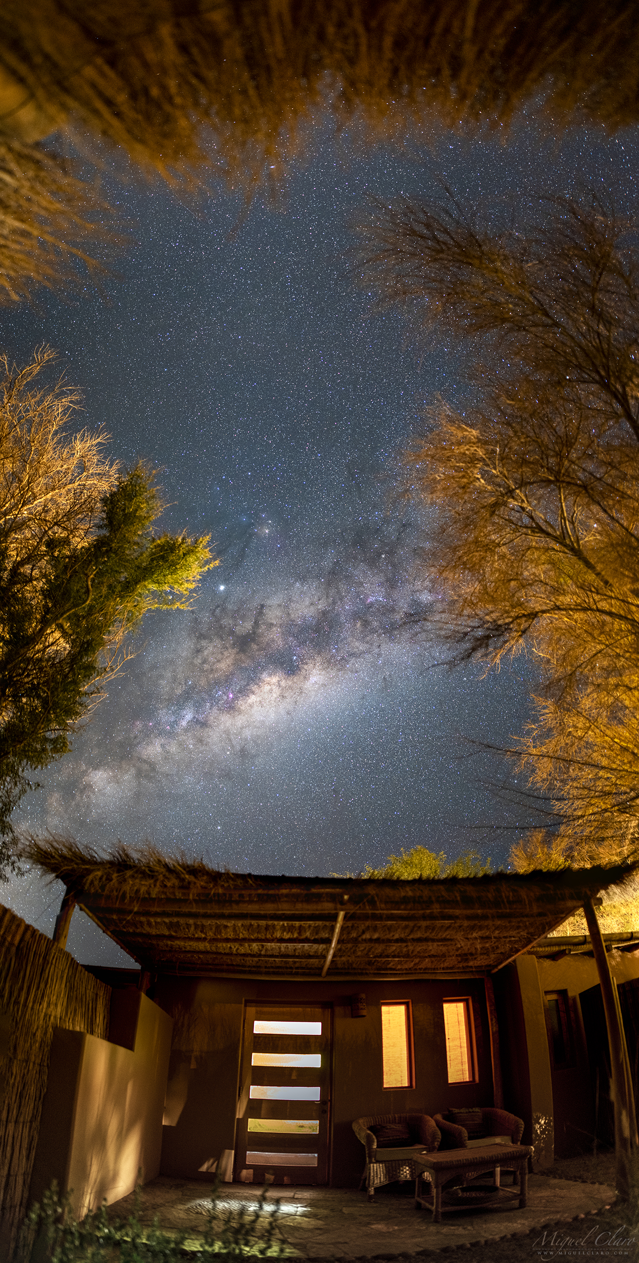
A vertical panorama of single frames features the core of our home galaxy, the Milky Way, full of bright emission nebulae visible in red/violet hues. Located high in the sky at this time of the year in the Southern Hemisphere, was framed above my hotel´s “hut” with a lovely view to an incredible starry sky, between the branches of some trees from a small village in Atacama Desert, called San Pedro de Atacama, in Chile. For those like me that are based in the Northern Hemisphere, a sky like that seems to be inverted, although, the bright light of Jupiter in the top center, helped to recognize the Dark River, dark absorption nebulas that extends from the central band of Milky Way, connecting the Pipe Nebula to the colourful region near bright star Antares, Rho Ophiuchi in Scorpius constellation.
PT: Um panorama vertical revela o núcleo da nossa galáxia, a Via Láctea, cheia de nebulosas de emissão brilhantes visíveis em tons de vermelho / violeta. Localizada bem alto no céu nesta época do ano, no Hemisfério Sul, é visível logo acima da “cabana” do meu hotel, com uma vista incrível por entre os galhos de algumas árvores de uma pequena vila no deserto de Atacama, chamada San Pedro de Atacama, no Chile. Para aqueles que como eu, habitam no Hemisfério Norte, um céu assim parece invertido, embora a luz brilhante de Júpiter no centro superior, tenha ajudado a reconhecer o Dark River, as nebulosas escuras de absorção que se estendem da faixa central de Via Láctea, conectando a Pipe Nebula à região colorida perto da brilhante estrela Antares, conhecida como Rho Ophiuchi, na constelação do Escorpião.
Sharing Knowledge and Learning is One of the Best Pleasures in the World

Sharing knowledge and learning something we love to do, is one of the best pleasures in the world! The image features the silhouette of one of my students @joao_rosario_godinho during a workshop of astrophotography, presented in Campinho village, located in the award winning @darkskyalqueva reserve, Portugal. While he is standing against the background core of our own galaxy, – the Milky Way – a white light that shines in the same direction belongs to a giant planet, Jupiter, which reached the Opposition during June month. If you would like to join one of my WORKSHOPS, for groups or as a Private experience, please visit my page Workshops and contact me for more informations.
PT: Partilhar o conhecimento ou aprender algo que gostamos de fazer é um dos melhores prazeres do mundo! A imagem revela a silhueta de um dos meus alunos @joao_rosario_godinho durante um workshop de astrofotografia na vila de Campinho, localizada na premiada reserva @darkskyalqueva, em Portugal. Enquanto o João prepara a sua câmara – num contra-luz provocado pelo brilho da Via Láctea – é visível uma luz branca que se destaca contra o coração galáctico. Essa luz pertence a um gigante gasoso, o Magnífico Júpiter, que no passado mês de Junho atingiu a Oposição, altura mais favorável para o fotografar e observar. Se gostaria de participar num dos meus workshops, e aprender tudo sobre a fotografia nocturna e as téncias mais avançadas, seja numa experiência de grupo ou como um workshop Privado one-to-one, visite minha página WORKSHOPS e entre em contato comigo para obter mais informações.
Spica and Arcturus are Shinning in a Starry Sky over Tua Valley

Located between Pombal de Ansiães and the place of S. Lourenço, this belvedere, allow us to enjoy a privileged night scene over the Tua Valley, a magnificent landscape marked by a nice cut of the mountains spread with vineyards, olive trees and cork oaks. Elegant curved lines drawn by Tua River are reflecting the faint light that remains visible from the abandoned old village of São Lourenço. Above the horizon, stars from the small constellation of Corvus are visible, while above them, the bright blue star Spica is shinning in Virgo constellation. In the top center, Arcturus from Bootes, is the brightest star visible on the image. Further to the right edge, we can find the open cluster “Melotte 111” in Coma Berenices.
PT: Localizado entre Pombal de Ansiães e o lugar de S. Lourenço, este miradouro, permite-nos desfrutar de uma noite privilegiada sobre o Vale do Tua, uma magnífica paisagem marcada por montanhas repletas de vinhas, oliveiras e sobreiros. Linhas curvas elegantes desenhadas pelo Rio Tua refletem a luz fraca que permanece visível da antiga vila abandonada de São Lourenço. Acima do horizonte, são visíveis as estrelas da pequena constelação Corvus, enquanto acima dela, a brilhante estrela azul Spica destaca-se na constelação da Virgem. Na parte superior central, Arcturus da constelação Bootes, é a estrela mais brilhante visível na imagem. Seguindo para a extremidade direita da imagem, podemos encontrar o enxame aberto “Melotte 111” em Coma Berenices.
Technical details | Detalhes Técnicos
A vertical panorama captured with a Nikon D810a | 24mm at f/2,8 | ISO3200 | Exp. 20 secs.
Winter Corona Surrounding a Full Cold Moon

This relatively abstract view captured in a double exposure with focus stacking, shows the Full Moon of December, behind a layer of clouds and immersed between dozens of branches from a foreground tree. The colourful hue that surrounds the moon, is a lunar corona formed while bright moonlight is diffracted by water droplets in thin clouds, drifting in front of the lunar disk. The image was captured in the historic centre of Évora, a UNESCO World Heritage site, located in Dark Sky® Alqueva reserve, Portugal. According to the Old Farmer’s Almanac, the December full moon is also called the “Full Cold Moon”. The last time a full moon coincided with the solstice was in 2010, and the next will be in 2094.
PT: Uma visão relativamente abstrata captada em uma dupla exposição com focus stacking, mostra uma Lua Cheia envolta numa fina camada de nuvens e imersa entre dezenas de galhos de uma árvore que em contra-luz, se destaca em primeiro plano. As tonalidades coloridas que circundam a lua, são provocadas por um corona lunar, que se forma enquanto o brilho da lua é difractado por gotículas de água em nuvens finas, flutuando assim na frente do disco lunar. A imagem foi captada no centro histórico de Évora, Património Mundial da UNESCO, e inserido na reserva Dark Sky® Alqueva. De acordo com o Almanaque do Velho Fazendeiro, a lua cheia de dezembro também é chamada de “Full Cold Moon”. A última vez que uma lua cheia coincidiu com o solstício de inverno foi em 2010, sendo que a próxima só voltará a ocorrer em 2094.
A Panoramic Milky Way Above Azenhas do Guadiana

An impressive panoramic view shows the Milky Way rising above the hills from the fluvial beach of Azenhas do Guadiana, in Dark Sky® Alqueva Mértola. While a family of ducks are standing near the water in the center of the picture, two photographers are capturing the wonders of the night sky during a workshop of astrophotography. At the right side of this scenic view, the core of our galaxy is shinning bright and with it, some deep sky objects like the Lagoon Nebula, visible in red-violet immediately above the hill top.
Milky Way, Andromeda and a Dutch Sailboat

Visible below two galaxies, our Great Milky Way that stands bright at the top of this vertical panorama and Andromeda Galaxy, the diffuse elliptic shape shining near the center of the image, is Sem Fim boat. A Westlander sailboat built in 1913 in Holland. This type of boat, was used in the Dutch channels for the transport of goods, among them flowers. It was later transformed into house and bring it to Portugal. Now it navigates in Alqueva lake giving tourists the experience of sailing in the wind on board of a vintage boat. The image was captured during the XII edition of Dark Sky® Party Alqueva, held annually in Campinho, Dark Sky® Alqueva reserve.
A Pinky Sky with a Golden Moon above Niagara Falls

Created by glacier activity around 10000 years ago, Niagara Falls is one the of the World’s Natural Wonders. Located on the border of Ontario, Canada and New York State, USA, Niagara Falls are made up of 3 waterfalls, the American Falls, the Bridal Veil Falls and the Horseshoe Falls. The 3 waterfalls combined, is producing the highest flow rate of any waterfall on Earth. The Horseshoe Falls are 180 feet (57 meters) high and allow 6 million cubic feet (168,000 cubic meters) of water every minute during peak daytime tourist hours, “that is about a million bathtubs full of water every minute”! Although, according this and having in mind the total volume of our natural satellite, the Moon, with 2.1958e10 km3 it would need to take of about 248 years to fill up the entire sphere that represents the body of the Moon. The rapids above the Falls reach a maximum speed of 40 km/h, but the fastest speeds occur at the Falls with 109 km/h. Niagara River expert, Wes Hill, estimates that 90 % of the fish can survive from the huge drop. At the current rate of erosion, scientists believe that the Niagara Falls will be gone in around 50000 years, luckily you still have time to be one of the 30 million people that every year are visiting the place. The image shows a golden crescent moon against the pink band from anti-twilight arch, or “Belt of Venus”, visible few minutes after the sunset when lots of birds are flying above American Falls & Bridal Veil Falls. Below, a boat from Hornblower Niagara Cruises, not so iconic as The Maid of the Mist that made its first trip in 1846, is carrying aboard hundreds of people that in the background has a massive flow of 567,811 liters of water falling each second.
PT: Criada pela atividade glacial há cerca de 10000 anos, as Cataratas do Niágara são uma das maravilhas naturais do mundo. Localizadas na fronteira de Ontário, Canadá e Estado de Nova York, EUA, as Cataratas do Niágara são compostas por 3 cataratas, as Cataratas Americanas, as Cataratas de Bridal Veil e as Cataratas Canadenses. As Cataratas Horseshoe têm 180 pés (57 metros) de altura e permitem a passagem de 168.000 metros cúbicos de água a cada minuto, durante o dia e no horário de pico turístico, isto é, cerca de um milhão de banheiras cheias de água a cada minuto! No entanto, de acordo com esses dados e tendo em mente o volume total de nosso satélite natural da Tera, a Lua, com 2.1958e10 km3, seria necessário cerca de 248 anos para preencher toda a esfera que representa o corpo da Lua. Acima das Cataratas a água atinge uma velocidade máxima de 40 km/h, mas as velocidades mais rápidas ocorrem nas Cataratas onde a água se precipita em queda livre atingindo os 109 km/h. O especialista do Rio Niágara, Wes Hill, estima que 90% dos peixes conseguem sobreviver da enorme queda. No ritmo atual de erosão, os cientistas acreditam que as Cataratas do Niágara terão desaparecido em cerca de 50000 anos, felizmente ainda terá tempo de ser uma das 30 milhões de pessoas que todos os anos visitam o local. A imagem mostra uma lua crescente dourada contra a faixa rosa do arco anti-crepuscular, ou também conhecido por Belt of Venus, poucos minutos após o pôr do sol, quando muitos pássaros voam acima de American Falls e Bridal Veil Falls. Abaixo, um barco da Hornblower Niagara Cruises, não tão icónico como o Maid of the Mist que fez a sua primeira viagem em 1846, carrega a bordo centenas de pessoas que em pano de fundo têm um fluxo de 567.811 litros de água caindo a cada segundo da viagem.

A Colorful Universe Revealed in the Earth Motion

When we first look at the night sky, we can not distinguish the color of each star with our own eyes, although, if we record in a long exposure sequence the path of each star, due to the motion of rotating Earth and consequently the rotation of celestial sphere, a starry trailed sky can reveal much of our colorful Universe. In the image above, captured in Noudar Park, Alqueva Dark Sky® Reserve, Portugal, we can see a lot of different color paths, like: blue, white, yellow or even orange. Each color is directly related to the type and temperature of each star. The hottest stars, are showing a blue color, but in opposition the coolest, can reveal an orange-reddish color.
In astronomy, stellar classification is the classification of stars based on their spectral characteristics. Electromagnetic radiation from the star is analyzed by splitting it with a prism or diffraction grating into a spectrum exhibiting the rainbow of colors interspersed with absorption lines. Each line indicates an ion of a certain chemical element, with the line strength indicating the abundance of that ion. The relative abundance of the different ions varies with the temperature of the photosphere. The spectral class of a star is a short code summarizing the ionization state, giving an objective measure of the photosphere’s temperature and density.
Most stars are currently classified under the Morgan–Keenan (MK) system using the letters O, B, A, F, G, K, and M, a sequence from the hottest (O type – blue stars) to the coolest (M type – red stars). Each letter class is then subdivided using a numeric digit with 0 being hottest and 9 being coolest (e.g. A8, A9, F0, F1 form a sequence from hotter to cooler). The sequence has been expanded with classes for other stars and star-like objects that do not fit in the classical system, such as class D for white dwarfs and class C for carbon stars.
In the MK system, a luminosity class is added to the spectral class using Roman numerals. This is based on the width of certain absorption lines in the star’s spectrum, which vary with the density of the atmosphere and so distinguish giant stars from dwarfs. Luminosity class 0 or Ia+ stars for hypergiants, class I stars for supergiants, class II for bright giants, class III for regular giants, class IV for sub-giants, class V for main-sequence stars, class sd for sub-dwarfs, and class D for white dwarfs. The full spectral class for the Sun is then G2V, indicating a main-sequence star with a temperature around 5,800 K. Source and more info: click here.
PT: Quando de noite olhamos para o céu não conseguimos percepcionar com os nossos próprios olhos a cor de cada estrela, no entanto, se registarmos numa sequência de longa exposição o rasto de cada estrela, devido ao movimento de rotação da Terra e à consequente rotação da esfera celeste, uma imagem startrail poderá revelar um Universo colorido e rico em informação. Na imagem acima captada no Parque de Natureza de Noudar, Reserva Dark Sky® Alqueva, em Barrancos, podemos ver uma grande diversidade de cores desde o azul, ao amarelo, branco ou laranja. Cada cor está directamente relacionada com o tipo e temperatura de cada estrela. Algumas delas são mais quentes e por isso apresentam uma cor mais azulada, outras por sua vez são mais frias apresentando uma cor mais alaranjada.
A Galactic Tree Under the Stars

A path of light illuminates the foreground behind a dead tree that by illusion, seems to be part of the galactic arm of our Milky Way galaxy. This magical and charm scenario under the stars was captured in Noudar Park, Alqueva Dark Sky® Reserve, Barrancos.
PT: Um caminho de luz ilumina o primeiro plano por detrás de uma árvore morta que, por ilusão, parece fazer parte do braço galáctico da nossa Via Láctea. Este cenário mágico e de encanto sob a luz das estrelas foi captado no Parque de Natureza de Noudar, Dark Sky® Alqueva, Barrancos.
A Spring Milky Way Shines above Monsaraz

With the arrival of Spring in the Northern Hemisphere the central region of Milky Way starts to be visible right above the horizon before Dawn, with the certain of getting better and better in the upcoming months, reaching it´s highest visibility to the naked eye in the middle of summer with the core of Milky Way facing south, and being well visible in the beginning of the night from a Dark Sky location. This scene captured in the spring equinox from Monsaraz village, in Dark Sky® Alqueva, shows a green field with small yellow flowers while in the sky, planets Saturn and Mars are shining against the the core of our galaxy, being Mars very close to the Lagoon nebula. In the upper right corner of the image, the bright light that cauth our attention is from the planet Jupiter.
PT: Com a chegada da primavera no Hemisfério Norte, a região central da Via Láctea começa a ficar visível logo acima do horizonte pouco tempo antes do nascer do dia, com a certeza de se encontrar cada vez melhor nos próximos meses, atingindo a sua maior visibilidade a olho nu nos meses de verão, com o núcleo da Via Láctea voltado a sul e sendo bem visível no início da noite a partir de um local escuro. Este cenário celeste captado no equinócio da primavera a partir de Monsaraz, no Dark Sky® Alqueva, mostra um campo verde com pequenas flores amarelas enquanto no céu, os planetas Saturno e Marte brilham contra o núcleo da nossa galáxia, estando Marte muito perto da Nebulosa da Lagoa. No canto superior direito da imagem, a luz brilhante que chama a nossa atenção é do planeta Júpiter.
An Earthshine from the Waning Crescent Moon

The photo shows a Waning Crescent Moon rising at Dawn, against a beautiful background from the twilight, just few minutes before the Sunrise. Captured above Monsaraz and lake Alqueva, in Dark Sky® Alqueva reserve, and due to the fact that during this time of the Month the disk was only 6% illuminated by Sun, we can clearly distinguish the Earthshine, a phenomenon related to that part of the Moon that is not directly illuminated by the Sun, but by the reflected light from Earth itself.
PT: Na foto é possível ver uma lua minguante que se levanta às primeiras horas do dia, contra um colorido fundo crepuscular, apenas alguns minutos antes do Sol nascer. Captada acima de Monsaraz, na reserva Dark Sky® Alqueva, e devido ao facto de que durante este período do mês o disco lunar se encontra apenas 6% iluminado pelo Sol, podemos distinguir claramente um Earthshine, um fenómeno relacionado com a parte da Lua que não se encontra diretamente iluminada pelo Sol, mas pela luz refletida da própria Terra.

The Path of Light from a Super Blue Moon

The path of light from a Super Blue Moon is rising behind a windmill from Sesimbra, in Portugal. The second Full Moon of the month is well known as the “Blue Moon”. Supermoons happen when a full moon approximately coincides with the moon’s perigee, or a point in its orbit at which it is closest to Earth. This makes the moon appear up to 8 percent larger and 16 percent brighter than usual. The Super Moon from January 2018 was very unusual because it also happened a Total Lunar Eclipse, although, it was not visible from Portugal. Below is a Time Lapse sequence captured during Moonrise.
PT: O rasto de luz de uma Super “Blue Moon” ergue-se por detrás de um moinho de vento de Sesimbra, em Portugal. A segunda Lua cheia do mês é conhecida como a “Lua Azul” ou “Blue Moon”. As popularmente designadas Super Luas acontecem, quando uma lua cheia coincide aproximadamente com o perigeu da lua, o ponto em sua órbita que está mais próximo da Terra. Isso faz com que a lua apareça até 8% maior e 16% mais brilhante do que o normal. A Super Lua de janeiro de 2018 foi muito incomum porque também permitiu a ocorrência de um Eclipse Lunar Total, embora não fosse visível de Portugal. Abaixo está uma sequência Time Lapse captada durante o nascer da lua.
Super Blue Moon, Rising Behind a Wind Mill

A Super Blue Moon rising above a wind mill from Sesimbra, in Portugal. The second Full Moon of the month is well known as the “Blue Moon”. Supermoons happen when a full moon approximately coincides with the moon’s perigee, or a point in its orbit at which it is closest to Earth. This makes the moon appear up to 8 percent larger and 16 percent brighter than usual. The Super Moon from January 2018 was very unusual because it also happened a Total Lunar Eclipse, although, it was not visible from Portugal. Below is a Time Lapse sequence captured during Moonrise.
PT: Uma Super “Blue Moon” ergue-se acima de um moinho de vento de Sesimbra, em Portugal. A segunda Lua cheia do mês é conhecida como a “Lua Azul” ou “Blue Moon”. As popularmente designadas Super Luas acontecem, quando uma lua cheia coincide aproximadamente com o perigeu da lua, o ponto em sua órbita que está mais próximo da Terra. Isso faz com que a lua apareça até 8% maior e 16% mais brilhante do que o normal. A Super Lua de janeiro de 2018 foi muito incomum porque também permitiu a ocorrência de um Eclipse Lunar Total, embora não fosse visível de Portugal. Abaixo está uma sequência Time Lapse captada durante o nascer da lua.
Lunar Christmas Earthshine above Mértola Castle

Captured one day after the new moon during the Christmas week, the moon was only 2% illuminated by the sunlight. Though, we can clearly distinguish the entire disk due to a phenomenon called Lunar Earthshine. In the foreground, located in a top hill, is a beautiful well-preserved medieval castle from Mértola village, in Dark Sky® Alqueva Reserve, decorated with Christmas lights around the walls and by coincidence very well aligned with the crescent moon, forming the perfect frame for a Christmas Card.
PT: Captada no dia após a lua nova e durante a semana que antecede o Natal, a lua encontrava-se 2% iluminada pela luz solar directa. No entanto, é possível distinguir claramente todo o disco devido a um fenómeno chamado Lunar Earthshine. Em primeiro plano, localizado numa colina superior, encontra-se o bem preservado e belo castelo da vila de Mértola, na Reserva Dark Sky® Alqueva, decorado com luzes de Natal ao redor das paredes e por coincidência muito bem alinhado com a lua crescente, forma o par perfeito para um Postal de Natal.
The Arch of Milky Way Shinning Against the Acid Landscape of Achada do Gamo

The arch of Milky Way galaxy behind a tiny layer of clouds mixed with a smooth presence of green airglow, is shinning above a puddle of acid water from Achada do Gamo, that was – since the beginning of modern mining activities in the São Domingos Mine – the center of metallurgical activities on extracted minerals. Already during the 20th century, between the 30s and 40s, a new direction of industrial exploration took place: the sulfur, however much valued, began to be extracted from the copper pyrites through furnaces (Orkla process) in two plants installed in the Achada do Gamo during the years of 1934 and 1943. Near the left chimney is visible the Andromeda galaxy, seen from here as an elongated diffuse dot.
São Domingos Mine is located in Baixo Alentejo, about 240 km from Lisbon, in the municipality of Mértola, which recently joined the Dark Sky® Alqueva Route for the great quality of the night sky. The São Domingos mining area is part of the Iberian Pyrite Range and is a decisive source of basic metals (S, Zn, Pb, Sn, Ag, Au, Fe, Co, Cd, etc.) and other elements such as sulfur (S). It has been a sought after place for the extraction of ores since antiquity, with evidence of gold, silver and copper mining in the pre-Roman and Roman times. The pyritic deposit of São Domingos (St. Dominic) was explored in various historical periods, namely: for several centuries of the first millennium BC (Eastern period), during the period between 14 BC and 395 AD (Roman period), during the Islamic period and during the modern period that was initiated in 1858 for the extraction of copper, gold and silver and was maintained until 1966, the year in which the reserves were considered exhausted. During this period, the work was done in the open air up to 120 meters deep, with work continued through wells and galleries up to 400 meters. Over 108 years of regular exploration, more than 20 million tons of materials were removed from the site, producing about 14.7 million tons of waste accumulated in heaps up to 14 meters high with a dozen different materials such as pyrite , gossan, slag, ash, iron oxides, barren rock, sludge, debris, etc. The areas of heaps, slag and channels of water, give the landscape a “lunar” aspect. The heaps are composed of different materials with high levels of metals, such as slag and ash, whose leaching through the rainwater leads to the production of acid mine drainage, usually with an ocher or reddish color.|
PT: O arco da Via Láctea ergue-se por detrás de uma fina camada de nuvens que se mistura em pano de fundo com a presença suave de airglow, tornando-se visível acima das águas ácidas da Achada do Gamo, que foi desde o início das atividades modernas de mineração na Mina de São Domingos, o centro das atividades metalúrgicas sobre os minérios extraídos. Já durante o século XX, entre as décadas de 30 e 40, uma nova direção de exploração industrial tomou lugar: o enxofre, entretanto muito valorizado, passou a ser extraído das pirites cupríferas através de fornos (processo Orkla) em duas unidades fabris instaladas na Achada do Gamo durante os anos de 1934 e 1943. Logo acima do horizonte esquerdo, e perto da primeira chaminé, é visível a galáxia de Andrómeda, vista a partir daqui como um ponto difuso alongado.
A Mina de São Domingos, situa-se no Baixo Alentejo, a cerca de 240 km de Lisboa, no concelho de Mértola, que passou a integrar recentemente a Rota Dark Sky® Alqueva pela grande qualidade do seu céu escuro. A área mineira de São Domingos, está inserida na Faixa Piritosa Ibérica e constitui uma fonte decisiva de metais básicos (Cu, Zn, Pb, Sn, Ag, Au, Fe, Co, Cd, etc.) e de outros elementos como o enxofre (S). Foi desde a Antiguidade um local procurado para a extracção de minérios, existindo indícios de trabalhos de extracção de ouro, prata e cobre no período pré-romano e romano. O depósito pirítico de São Domingos foi explorado em diversos períodos históricos, nomeadamente: durante vários séculos do primeiro milénio a.C. (período Oriental), durante o período que mediou entre o ano 14 a.C. e o ano de 395 d.C. (período romano), durante o período islâmico e durante o período moderno que se iniciou em 1858 para a extracção de cobre, ouro e prata e manteve-se até 1966, ano em que as reservas foram consideradas esgotadas. Neste período, a lavra foi feita a céu aberto até aos 120 metros de profundidade, tendo os trabalhos continuado por meio de poços e galerias até aos 400 metros. Ao longo de 108 anos de exploração regular, foram retirados do local mais de 20 milhões de toneladas de materiais, tendo produzido cerca 14,7 milhões de toneladas de resíduos acumulados em escombreiras de até 14 metros de altura, com uma dezena de materiais diferentes como pirite, gossan, escórias, cinzas, óxidos de ferro, rocha estéril, lamas, entulhos, etc. As áreas de escombreiras, escórias e canais de água, dão à paisagem um aspecto “lunar”. As escombreiras são constituídas por diferentes materiais com teores elevados em metais, como escórias e cinzas, cuja lixiviação através das águas das chuvas leva à produção de águas ácidas (‘acid mine drainage’), geralmente com uma cor ocre ou avermelhada.
Summer Triangle and Planet Saturn Shinning above Achada do Gamo

A view of the Milky Way arm with planet Saturn shinning against the galaxy core, near Scorpius constellation. In the top right corner of the image, a pink/red emission from North America Nebula (NGC7000) is well visible near Deneb star, forming a perfect triangle with the blue star Vega (top center) and Altair star (left center). This mosaic of the Milky Way was captured above a puddle of acid water from Achada do Gamo, that was – since the beginning of modern mining activities in the São Domingos Mine – the center of metallurgical activities on extracted minerals. Already during the 20th century, between the 30s and 40s, a new direction of industrial exploration took place: the sulfur, however much valued, began to be extracted from the copper pyrites through furnaces (Orkla process) in two plants installed in the Achada do Gamo during the years of 1934 and 1943.
São Domingos Mine is located in Baixo Alentejo, about 240 km from Lisbon, in the municipality of Mértola, which recently joined the Dark Sky® Alqueva Route for the great quality of the night sky. The São Domingos mining area is part of the Iberian Pyrite Range and is a decisive source of basic metals (S, Zn, Pb, Sn, Ag, Au, Fe, Co, Cd, etc.) and other elements such as sulfur (S). It has been a sought after place for the extraction of ores since antiquity, with evidence of gold, silver and copper mining in the pre-Roman and Roman times. The pyritic deposit of São Domingos (St. Dominic) was explored in various historical periods, namely: for several centuries of the first millennium BC (Eastern period), during the period between 14 BC and 395 AD (Roman period), during the Islamic period and during the modern period that was initiated in 1858 for the extraction of copper, gold and silver and was maintained until 1966, the year in which the reserves were considered exhausted. During this period, the work was done in the open air up to 120 meters deep, with work continued through wells and galleries up to 400 meters. Over 108 years of regular exploration, more than 20 million tons of materials were removed from the site, producing about 14.7 million tons of waste accumulated in heaps up to 14 meters high with a dozen different materials such as pyrite , gossan, slag, ash, iron oxides, barren rock, sludge, debris, etc. The areas of heaps, slag and channels of water, give the landscape a “lunar” aspect. The heaps are composed of different materials with high levels of metals, such as slag and ash, whose leaching through the rainwater leads to the production of acid mine drainage, usually with an ocher or reddish color.|
PT: Uma visão do braço da Via Láctea com o planeta Saturno brilhando contra o centro da galáxia, perto da constelação do Escorpião. No canto superior direito da imagem, uma emissão rosa/vermelha proveniente da Nebulosa América do Norte (NGC7000) é bem visível perto da estrela Deneb, formando um triângulo perfeito com a estrela azul Vega (centro superior) e a estrela Altair (centro esquerdo). Este mosaico da Via Láctea foi captado acima das águas ácidas da Achada do Gamo, que foi desde o início das atividades modernas de mineração na Mina de São Domingos, o centro das atividades metalúrgicas sobre os minérios extraídos. Já durante o século XX, entre as décadas de 30 e 40, uma nova direção de exploração industrial tomou lugar: o enxofre, entretanto muito valorizado, passou a ser extraído das pirites cupríferas através de fornos (processo Orkla) em duas unidades fabris instaladas na Achada do Gamo durante os anos de 1934 e 1943.
A Mina de São Domingos, situa-se no Baixo Alentejo, a cerca de 240 km de Lisboa, no concelho de Mértola, que passou a integrar recentemente a Rota Dark Sky® Alqueva pela grande qualidade do seu céu escuro. A área mineira de São Domingos, está inserida na Faixa Piritosa Ibérica e constitui uma fonte decisiva de metais básicos (Cu, Zn, Pb, Sn, Ag, Au, Fe, Co, Cd, etc.) e de outros elementos como o enxofre (S). Foi desde a Antiguidade um local procurado para a extracção de minérios, existindo indícios de trabalhos de extracção de ouro, prata e cobre no período pré-romano e romano. O depósito pirítico de São Domingos foi explorado em diversos períodos históricos, nomeadamente: durante vários séculos do primeiro milénio a.C. (período Oriental), durante o período que mediou entre o ano 14 a.C. e o ano de 395 d.C. (período romano), durante o período islâmico e durante o período moderno que se iniciou em 1858 para a extracção de cobre, ouro e prata e manteve-se até 1966, ano em que as reservas foram consideradas esgotadas. Neste período, a lavra foi feita a céu aberto até aos 120 metros de profundidade, tendo os trabalhos continuado por meio de poços e galerias até aos 400 metros. Ao longo de 108 anos de exploração regular, foram retirados do local mais de 20 milhões de toneladas de materiais, tendo produzido cerca 14,7 milhões de toneladas de resíduos acumulados em escombreiras de até 14 metros de altura, com uma dezena de materiais diferentes como pirite, gossan, escórias, cinzas, óxidos de ferro, rocha estéril, lamas, entulhos, etc. As áreas de escombreiras, escórias e canais de água, dão à paisagem um aspecto “lunar”. As escombreiras são constituídas por diferentes materiais com teores elevados em metais, como escórias e cinzas, cuja lixiviação através das águas das chuvas leva à produção de águas ácidas (‘acid mine drainage’), geralmente com uma cor ocre ou avermelhada.
Moonlight and Jupiter Shinning above Corta da Mina Landscape

A Moonlight scene in a cloudy sky with bright planet Jupiter shinning above Corta da Mina landscape, that is the result of the open-pit mining operation begun in 1867 in São Domingos Mine. It has a geometrical shape of an ellipse and a depth of 120 m and a perimeter of approximately 2 km. It was the place from which the ores were extracted: the pyrites, sulfur, copper, iron, zinc, gold and silver. Around the cavity it is possible to observe several types of heaps constituted by diverse materials such as modern slag of black color, brownish Roman slag, gossan fragments of reddish color and encasing mineralization rocks like vulcanites and schists. Some of these commons have significant gold contents assuming the presence of iMt from heaps with 1g / t gold. ” After the end of the work, in 1966, the abandonment of the extraction of water from the bottom of the mine allowed the rise groundwater level within the cut to the current, apparently stationary point. The water currently contained in the cut is extremely acidic (Ph = 2) giving the water an incredible color variation with colours ranging from reddish tones to oranges and yellows, it contains a large amount of dissolved sulfates, mainly iron and arsenic sulfates, but also copper and zinc.
São Domingos Mine is located in Baixo Alentejo, about 240 km from Lisbon, in the municipality of Mértola, which recently joined the Dark Sky® Alqueva Route for the great quality of the night sky. The São Domingos mining area is part of the Iberian Pyrite Range and is a decisive source of basic metals (S, Zn, Pb, Sn, Ag, Au, Fe, Co, Cd, etc.) and other elements such as sulfur (S). It has been a sought after place for the extraction of ores since antiquity, with evidence of gold, silver and copper mining in the pre-Roman and Roman times. The pyritic deposit of São Domingos (St. Dominic) was explored in various historical periods, namely: for several centuries of the first millennium BC (Eastern period), during the period between 14 BC and 395 AD (Roman period), during the Islamic period and during the modern period that was initiated in 1858 for the extraction of copper, gold and silver and was maintained until 1966, the year in which the reserves were considered exhausted. During this period, the work was done in the open air up to 120 meters deep, with work continued through wells and galleries up to 400 meters. Over 108 years of regular exploration, more than 20 million tons of materials were removed from the site, producing about 14.7 million tons of waste accumulated in heaps up to 14 meters high with a dozen different materials such as pyrite , gossan, slag, ash, iron oxides, barren rock, sludge, debris, etc. The areas of heaps, slag and channels of water, give the landscape a “lunar” aspect. The heaps are composed of different materials with high levels of metals, such as slag and ash, whose leaching through the rainwater leads to the production of acid mine drainage, usually with an ocher or reddish color. |
PT: Um cenário ao Luar com a presença do planeta Jupiter a brilhar por detrás de um céu nublado que se precipita acima da paisagem acida da Corta da Mina, o resultado da exploração mineira a céu aberto encetada em 1867 na Mina de São Domingos, em Mértola. Possui uma forma geométrica de uma elipse e uma profundidade de 120 m e um perímetro de aproximadamente 2 km. Era o local de onde se extraíam os minérios: as pirites, enxofre, cobre, ferro, zinco, ouro e prata. Em torno da cavidade é possível observar vários tipos de escombreiras constituídas por materiais diversos como escórias modernas de cor negra, escórias romanas acastanhadas, fragmentos de gossan de cor avermelhada e rochas encaixantes da mineralização como vulcanitos e xistos. Alguns destes corpos de encombros apresentam teores significativos de ouro admitindo-se a presença de iMt de escombreiras com 1g/t de ouro.” Após o fim da laboração, em 1966, o abandono da extração de água do fundo da mina permitiu a subida do nível freático dentro da corta até ao ponto atual, aparentemente estacionário.
A água hoje contida na corta é extremamente ácida (Ph=2) conferindo à água uma variação cromática incrível com cores que vão desde tons avermelhados, a laranjas e amarelos, contém uma grande quantidade de sulfatos dissolvidos, principalmente sulfatos de ferro e arsénico mas também de cobre e zinco
A Mina de São Domingos, situa-se no Baixo Alentejo, a cerca de 240 km de Lisboa, no concelho de Mértola, que passou a integrar recentemente a Rota Dark Sky® Alqueva pela grande qualidade do seu céu escuro. A área mineira de São Domingos, está inserida na Faixa Piritosa Ibérica e constitui uma fonte decisiva de metais básicos (Cu, Zn, Pb, Sn, Ag, Au, Fe, Co, Cd, etc.) e de outros elementos como o enxofre (S). Foi desde a Antiguidade um local procurado para a extracção de minérios, existindo indícios de trabalhos de extracção de ouro, prata e cobre no período pré-romano e romano. O depósito pirítico de São Domingos foi explorado em diversos períodos históricos, nomeadamente: durante vários séculos do primeiro milénio a.C. (período Oriental), durante o período que mediou entre o ano 14 a.C. e o ano de 395 d.C. (período romano), durante o período islâmico e durante o período moderno que se iniciou em 1858 para a extracção de cobre, ouro e prata e manteve-se até 1966, ano em que as reservas foram consideradas esgotadas. Neste período, a lavra foi feita a céu aberto até aos 120 metros de profundidade, tendo os trabalhos continuado por meio de poços e galerias até aos 400 metros. Ao longo de 108 anos de exploração regular, foram retirados do local mais de 20 milhões de toneladas de materiais, tendo produzido cerca 14,7 milhões de toneladas de resíduos acumulados em escombreiras de até 14 metros de altura, com uma dezena de materiais diferentes como pirite, gossan, escórias, cinzas, óxidos de ferro, rocha estéril, lamas, entulhos, etc. As áreas de escombreiras, escórias e canais de água, dão à paisagem um aspecto “lunar”. As escombreiras são constituídas por diferentes materiais com teores elevados em metais, como escórias e cinzas, cuja lixiviação através das águas das chuvas leva à produção de águas ácidas (‘acid mine drainage’), geralmente com uma cor ocre ou avermelhada.
Full Moon Emerging from an Acid Landscape

A Full Moon is reflected in a puddle of acid water from Achada do Gamo, that was – since the beginning of modern mining activities in the São Domingos Mine – the center of metallurgical activities on extracted minerals. The areas of heaps, slag and channels of water, give the landscape a “lunar” aspect, revealed in this image naturally illuminated by the Moonlight. The heaps are composed of different materials with high levels of metals, such as slag and ash, whose leaching through the rainwater leads to the production of acid mine drainage, usually with an ocher or reddish color.
São Domingos Mine is located in Baixo Alentejo, about 240 km from Lisbon, in the municipality of Mértola, which recently joined the Dark Sky® Alqueva Route for the great quality of the night sky. The São Domingos mining area is part of the Iberian Pyrite Range and is a decisive source of basic metals (S, Zn, Pb, Sn, Ag, Au, Fe, Co, Cd, etc.) and other elements such as sulfur (S). It has been a sought after place for the extraction of ores since antiquity, with evidence of gold, silver and copper mining in the pre-Roman and Roman times. The pyritic deposit of São Domingos (St. Dominic) was explored in various historical periods, namely: for several centuries of the first millennium BC (Eastern period), during the period between 14 BC and 395 AD (Roman period), during the Islamic period and during the modern period that was initiated in 1858 for the extraction of copper, gold and silver and was maintained until 1966, the year in which the reserves were considered exhausted. During this period, the work was done in the open air up to 120 meters deep, with work continued through wells and galleries up to 400 meters. Over 108 years of regular exploration, more than 20 million tons of materials were removed from the site, producing about 14.7 million tons of waste accumulated in heaps up to 14 meters high with a dozen different materials such as pyrite , gossan, slag, ash, iron oxides, barren rock, sludge, debris, etc.|
PT: A Lua Cheia reflectida nas águas ácidas da Achada do Gamo, que foi desde o início das atividades modernas de mineração na Mina de São Domingos, o centro das atividades metalúrgicas sobre os minérios extraídos. As áreas de escombreiras, escórias e canais de água, dão à paisagem um aspecto “lunar”, revelado nesta imagem nocturna pela luz natural do luar. As escombreiras são constituídas por diferentes materiais com teores elevados em metais, como escórias e cinzas, cuja lixiviação através das águas das chuvas leva à produção de águas ácidas (‘acid mine drainage’), geralmente com uma cor ocre ou avermelhada.
A Mina de São Domingos, situa-se no Baixo Alentejo, a cerca de 240 km de Lisboa, no concelho de Mértola, que passou a integrar recentemente a Rota Dark Sky® Alqueva pela grande qualidade do seu céu escuro. A área mineira de São Domingos, está inserida na Faixa Piritosa Ibérica e constitui uma fonte decisiva de metais básicos (Cu, Zn, Pb, Sn, Ag, Au, Fe, Co, Cd, etc.) e de outros elementos como o enxofre (S). Foi desde a Antiguidade um local procurado para a extracção de minérios, existindo indícios de trabalhos de extracção de ouro, prata e cobre no período pré-romano e romano. O depósito pirítico de São Domingos foi explorado em diversos períodos históricos, nomeadamente: durante vários séculos do primeiro milénio a.C. (período Oriental), durante o período que mediou entre o ano 14 a.C. e o ano de 395 d.C. (período romano), durante o período islâmico e durante o período moderno que se iniciou em 1858 para a extracção de cobre, ouro e prata e manteve-se até 1966, ano em que as reservas foram consideradas esgotadas. Neste período, a lavra foi feita a céu aberto até aos 120 metros de profundidade, tendo os trabalhos continuado por meio de poços e galerias até aos 400 metros. Ao longo de 108 anos de exploração regular, foram retirados do local mais de 20 milhões de toneladas de materiais, tendo produzido cerca 14,7 milhões de toneladas de resíduos acumulados em escombreiras de até 14 metros de altura, com uma dezena de materiais diferentes como pirite, gossan, escórias, cinzas, óxidos de ferro, rocha estéril, lamas, entulhos, etc.
Lonely Shadow in a Desert of Stars

In a remote place like a desert, faraway from light polluted cities, the Milky Way can reach a level of brightness enough to project a smooth shadow of a body on the ground, like the one of this stargazer that is contemplating the majestic sky from Zabriskie Point, part of Amargosa Range located east of Death Valley in Death Valley National Park in California, United States, noted for its erosional landscape. It is composed of sediments from Furnace Creek Lake, which dried up 5 million years ago—long before Death Valley came into existence. The hottest air temperature ever recorded in Death Valley was 134 °F (56.7 °C) on July 10, 1913, at Furnace Creek, which is the hottest atmospheric temperature ever recorded on earth.
Milky Way – A lost Candle in the Desert of Death Valley

Zabriskie Point is a part of Amargosa Range located east of Death Valley in Death Valley National Park, in California, United States, noted for its erosional landscape. It is composed of sediments from Furnace Creek Lake, which dried up 5 million years ago—long before Death Valley came into existence. The hottest air temperature ever recorded in Death Valley was 134 °F (56.7 °C) on July 10, 1913, at Furnace Creek, which is the hottest atmospheric temperature ever recorded on earth.During the heat wave that peaked with that record, five consecutive days reached 129 °F (54 °C) or above. In the center of the image, the core of Milky Way is shinning so bright, that creates the illusion like if it was enough to illuminate the right top of the mountain range from Zabriskie point. Although, the mountain was actually and momently illuminated by a car light that was passing by.
Milky Way from Zabriskie Point in Death Valley

Zabriskie Point is a part of Amargosa Range located east of Death Valley in Death Valley National Park in California, United States, noted for its erosional landscape. It is composed of sediments from Furnace Creek Lake, which dried up 5 million years ago—long before Death Valley came into existence. The hottest air temperature ever recorded in Death Valley was 134 °F (56.7 °C) on July 10, 1913, at Furnace Creek, which is the hottest atmospheric temperature ever recorded on earth.During the heat wave that peaked with that record, five consecutive days reached 129 °F (54 °C) or above. In the night that this panoramic scene was captured above Badlands from Zabriskie point, the air temperature near midnight was 41ºc.
The Arch of Milky Way was high in the Sky in that time of the year, making very difficult to capture this perfect “half of circle” touching the Zenith, where we can see in the top center, a blue bright star with an apparent magnitude of 0,0 called Vega, serving as a middle reference in the magnitude system chart created for the first time in 150 B.C.E, by the greek astronomer Hipparchus. Vega, from Lyra constellation, is forming an asterism well know as the “Summer Triangle” with stars Deneb (from Cygnus) and Altair (from Aquila). At the left side – in the beginning of the Milky Way – a bright elliptic and diffuse dot is the light coming from Andromeda Galaxy while in the opposite direction of the sky – right edge of the picture – the orange supergiant star of Antares, from Scorpius constellations, is setting below the hot horizon of Death Valley´s landscape. In the center right, and below the arch, is also visible a faint white light known as Gegenschein. It´s a faint brightening of the night sky in the region of the antisolar point. like the zodiacal light, the gegenschein is sunlight scattered by interplanetary dust.
Milky Way and a Reddish Moon Behind the Smoke of Fire in Yosemite

First protected in 1864, Yosemite National Park is best known for its waterfalls, but within its nearly 1,200 square miles, it´s full of beauty with deep valleys, grand meadows, ancient giant sequoias, and a vast wilderness area where the animals are living in harmony with the strength of granite, the power of glaciers, and the tranquility of the High Sierra, that shows the persistence of life even with the large and strong fires that seems to threaten all this area each summer.
A blaze in Yosemite National Park have create smoky skies. The South Fork Fire, started about a mile east of Wawona grew to more than 5,100 acres, while to the north, near Glacier Point Road, the Empire Fire, started by a lightning, and grew to more than 2,300 acres. In the park, areas like Yosemite Valley, Half Dome, and El Capitan have remained smoky for days. Due to this effect, we can see on the image taken in the Yosemite Valley, a reddish moon behind the smoke while at left side, the Milky Way is trying to shine. There are hints of red and brown but also blues in the clouds. Smoke particles are much smaller than the wavelengths of sunlight and scatter blue light much more strongly than red (Rayleigh scattering). The blues of the rays are strengthened whereas the clouds seen by transmission through shadowed smoky air have their light reddened because the blues are more strongly scattered from the direct beam.
Crepuscular Rays and Shadows in the Sky of Las Vegas

As seen above the city that never sleeps, Las Vegas, this cityscape shows the twilight sky with the dramatic effect of the phenomenon known as “Crepuscular rays”. In atmospheric optics, are rays of sunlight that appear to radiate from the point in the sky where the sun is located. These rays, which stream through gaps in clouds (particularly stratocumulus) or between other objects like mountains, are columns of sunlit air separated by darker cloud-shadowed regions. Despite seeming to converge at a point, the rays are in fact near-parallel shafts of sunlight, and their apparent convergence is a perspective effect (similar, for example, to the way that parallel railway lines seem to converge at a point in the distance).”
“The name comes from their frequent occurrences during crepuscular hours (those around dawn and dusk), when the contrasts between light and dark are the most obvious. Crepuscular comes from the Latin word “crepusculum”, meaning twilight.”
PT: Visto acima da cidade que nunca dorme, Las Vegas, nesta cityscape captada ao crepúsculo é possível ver o forte fenómeno dos “Raios Crepusculares e Sombras” projectadas no céu. Estes raios de luz solar irradiam do ponto do céu onde o sol se encontra, fluindo através de lacunas nas nuvens (particularmente estratocumulos) ou entre outros objetos como montanhas. São basicamente colunas de ar iluminadas pelo sol, separadas por regiões mais sombrias e sombreadas. Apesar de parecerem convergir de um único ponto, os raios são, de facto, os eixos paralelos da luz solar e a sua convergência aparente é um efeito de perspectiva (semelhante, por exemplo, ao modo como as linhas ferroviárias paralelas parecem convergir em um ponto distante).
The Shadow of Earth and Belt of Venus above Alqueva

In the background sky of this beautiful spring field scene from Alqueva region, is strongly visible above the horizon of Campinho village, the Earth’s shadow, which is the shadow that the Earth itself casts on its atmosphere. This shadow is visible in the opposite half of the sky to the sunset or sunrise, and is seen right above the horizon as a dark blue band. Immediately above, where the evening air is still lit, glows a pink band called the anti-twilight arch, also known as “Belt of Venus”, and is caused by backscattering of refracted sunlight due to fine dust particles high in the atmosphere. Captured during the twilight in Dark Sky® Alqueva Reserve.
PT: No céu de fundo desta paisagem primaveril alentejana, é possível ver logo acima do horizonte da aldeia do Campinho, um fenómeno conhecido como “Earth Shadow”, que é a sombra da própria Terra projectada na atmosfera. Apesar deste fenómeno atmosférico ser relativamente comum e visível durante o amanhecer e crepúsculo nem sempre é visível com tanta intensidade, passando despercebido a muitas das pessoas. Logo acima do tom azul escuro associada à sombra da Terra, encontramos numa tonalidade rosa o “Cinturão de Vénus” (Belt of Venus). Esta esplendorosa tonalidade rosácea ou arco anti-crepuscular, torna-se visível estendendo-se por cerca de 10°a 20 ° acima do horizonte. A cor rosa do arco deve-se à retro-difusão da luz avermelhada do nascer ou pôr do Sol. Imagem captada durante o crepúsculo no Campinho, Dark Sky® Alqueva.
A Musician Inspired by the Moonlight

The moon has inspired over the centuries not only astronomers and scientists, but also poets, painters, writers and musicians, such as Beethoven who wrote the “Moonlight Sonata” in 1801. The April full moon is the first full moon of spring in the Northern Hemisphere (it’s the first fall season full moon in the Southern Hemisphere). Also known as the Pink Moon does not actually turn pink, not even when it´s rising above the horizon when normally can be seen more yellowish orange than white due to the layers of the atmosphere. In fact, the moon never changes its colour. Similar the other “moon names” it was originated in Native American traditions of keeping time based on lunar phases. The Pink Moon owes its name to pink flowers called wild ground phlox which bloom in springtime and become widespread throughout the U.S. and Canada this time of year.
This single shot shows a beautiful moonlight scene inspired by musicians like Beethoven, and was captured in Borba, Alentejo, where we can see this April Full Moon rising in the background against the silhouette of a young women who is holding with love her violin in a small hill of a marble quarry.
EN: A lua tem inspirado ao longo dos séculos não só astrónomos e cientistas, mas também poetas, pintores, escritores e músicos, como Beethoven, que escreveu a “Sonata Moonlight” em 1801. A lua cheia de abril é a primeira lua cheia de primavera no Hemisfério Norte.
Também conhecida como a “Lua Cor-de-rosa” (Pink Moon), esta lua não se torna cor-de-rosa, nem mesmo quando está a nascer acima do horizonte em que pode ser vista numa tonalidade mais amarelada ou alaranjada devido ao efeito da atmosfera. Na verdade, a lua nunca muda de cor. Similar a outros “nomes de lua”, foi originado em tradições nativas americanas de manter o tempo baseado em fases lunares. A “Lua Cor-de-rosa” deve seu nome às flores cor-de-rosa chamadas Phlox Selvagem que florescem na primavera e tornam-se visíveis ao longo dos EUA e Canadá nesta época do ano.
Esta fotografia, resultado de um disparo único (single frame), mostra-nos uma bela cena de luar inspirada na música de Beethoven e outros músicos, e foi capturada em Borba, no Alentejo, onde podemos no fundo do céu esta Lua Cheia de Abril erguendo-se contra a silhueta de uma mulher que está segurando com amor seu violino, acima de uma pequena colina de uma pedreira de mármore.
Playing in the Moonlight

The moon has inspired over the centuries not only astronomers and scientists, but also poets, painters, writers and musicians, such as Beethoven who wrote the “Moonlight Sonata” in 1801. The April full moon is the first full moon of spring in the Northern Hemisphere (it’s the first fall season full moon in the Southern Hemisphere). Also known as the Pink Moon does not actually turn pink, not even when it´s rising above the horizon when normally can be seen more yellowish orange than white due to the layers of the atmosphere. In fact, the moon never changes its colour. Similar the other “moon names” it was originated in Native American traditions of keeping time based on lunar phases. The Pink Moon owes its name to pink flowers called wild ground phlox which bloom in springtime and become widespread throughout the U.S. and Canada this time of year.
This single shot shows a beautiful moonlight scene inspired by musicians like Beethoven, and was captured in Borba, Alentejo, where we can see this April Full Moon rising in the background against the silhouette of a young women who is holding with love her violin in a small hill of a marble quarry.
EN: A lua tem inspirado ao longo dos séculos não só astrónomos e cientistas, mas também poetas, pintores, escritores e músicos, como Beethoven, que escreveu a “Sonata Moonlight” em 1801. A lua cheia de abril é a primeira lua cheia de primavera no Hemisfério Norte.
Também conhecida como a “Lua Cor-de-rosa” (Pink Moon), esta lua não se torna cor-de-rosa, nem mesmo quando está a nascer acima do horizonte em que pode ser vista numa tonalidade mais amarelada ou alaranjada devido ao efeito da atmosfera. Na verdade, a lua nunca muda de cor. Similar a outros “nomes de lua”, foi originado em tradições nativas americanas de manter o tempo baseado em fases lunares. A “Lua Cor-de-rosa” deve seu nome às flores cor-de-rosa chamadas Phlox Selvagem que florescem na primavera e tornam-se visíveis ao longo dos EUA e Canadá nesta época do ano.
Esta fotografia, resultado de um disparo único (single frame), mostra-nos uma bela cena de luar inspirada na música de Beethoven e outros músicos, e foi capturada em Borba, no Alentejo, onde podemos no fundo do céu esta Lua Cheia de Abril erguendo-se contra a silhueta de uma mulher que está segurando com amor seu violino, acima de uma pequena colina de uma pedreira de mármore.
Beethoven´s Moonlight

The moon has inspired over the centuries not only astronomers and scientists, but also poets, painters, writers and musicians, such as Beethoven who wrote the “Moonlight Sonata” in 1801. The April full moon is the first full moon of spring in the Northern Hemisphere (it’s the first fall season full moon in the Southern Hemisphere). Also known as the Pink Moon does not actually turn pink, not even when it´s rising above the horizon when normally can be seen more yellowish orange than white due to the layers of the atmosphere. In fact, the moon never changes its colour. Similar the other “moon names” it was originated in Native American traditions of keeping time based on lunar phases. The Pink Moon owes its name to pink flowers called wild ground phlox which bloom in springtime and become widespread throughout the U.S. and Canada this time of year.
This single shot shows a beautiful moonlight scene inspired by musicians like Beethoven, and was captured in Borba, Alentejo, where we can see this April Full Moon rising in the background against the silhouette of a young women who is holding with love her violin in a small hill of a marble quarry.
EN: A lua tem inspirado ao longo dos séculos não só astrónomos e cientistas, mas também poetas, pintores, escritores e músicos, como Beethoven, que escreveu a “Sonata Moonlight” em 1801. A lua cheia de abril é a primeira lua cheia de primavera no Hemisfério Norte.
Também conhecida como a “Lua Cor-de-rosa” (Pink Moon), esta lua não se torna cor-de-rosa, nem mesmo quando está a nascer acima do horizonte em que pode ser vista numa tonalidade mais amarelada ou alaranjada devido ao efeito da atmosfera. Na verdade, a lua nunca muda de cor. Similar a outros “nomes de lua”, foi originado em tradições nativas americanas de manter o tempo baseado em fases lunares. A “Lua Cor-de-rosa” deve seu nome às flores cor-de-rosa chamadas Phlox Selvagem que florescem na primavera e tornam-se visíveis ao longo dos EUA e Canadá nesta época do ano.
Esta fotografia, resultado de um disparo único (single frame), mostra-nos uma bela cena de luar inspirada na música de Beethoven e outros músicos, e foi capturada em Borba, no Alentejo, onde podemos no fundo do céu esta Lua Cheia de Abril erguendo-se contra a silhueta de uma mulher que está segurando com amor seu violino, acima de uma pequena colina de uma pedreira de mármore.
The Transition between Day and Night

This lovely skyscape scene shows the end of nautical twilight above Roque de Los Muchachos observatory, and the transition between the end of the day and the beginning of the night. Each twilight phase is defined by the solar elevation angle, which is the position of the Sun in relation to the horizon. During nautical twilight, the geometric center of the Sun’s disk is between 6 and 12 degrees below the horizon. In clear weather conditions, the horizon is faintly visible during this twilight phase. Many of the brighter stars can also be seen, making it possible to use the position of the stars in relation to the horizon to navigate at sea. This is why it is called nautical twilight. Although, if we had to this ingredients the perfect position and time of the year to watch the central region of the Milky Way as soon as the sky stays dark, we can capture beyond the brightest stars the dusty core of the galaxy with very natural colours mixed yet with the background light coming from the transition of the Nautical Twilight to the Astronomical Twilight, when the Sun is even low then 12º below the horizon. In the foreground are spread different night and solar observatories from Roque de Los Mucahchos, one of them is William Herschel Telescope, that can be seen in the right edge of the image with the dome opened while it´s laser is pointed high up in the sky.
PT: Esta linda cena “skyscape” mostra o final do Crepúsculo Náutico acima do observatório Roque de Los Muchachos, e a transição entre o final do dia e o início da noite. Cada fase crepuscular é definida pelo ângulo de elevação solar, que é a posição do Sol em relação ao horizonte. Durante o Crepúsculo Náutico, o centro geométrico do disco do Sol está entre 6 e 12 graus abaixo do horizonte. Em condições climáticas claras, o horizonte é visível durante esta fase crepuscular. Muitas das estrelas mais brilhantes também podem ser vistas, tornando possível usar a posição das estrelas em relação ao horizonte para navegar no mar. É por isso que é chamado Crepúsculo Náutico. No entanto, se a estes ingredientes juntarmos a posição e época do ano perfeita para observar a região central da Via Láctea logo que o céu escureça, podemos captar além das estrelas mais brilhantes o núcleo empoeirado da galáxia com cores muito naturais, misturadas ainda com a luz de fundo proveniente da transição do Crepúsculo Náutico para o Crepúsculo Astronómico, quando o Sol está mais de 12º abaixo do horizonte. No primeiro plano, estão espalhados diferentes observatórios noturnos e solares do Roque de Los Mucahchos, um deles é o Telescópio William Herschel, que pode ser visto na extremidade direita da imagem com a cúpula aberta enquanto o laser é apontado para o alto do céu.
A wide view from Roque de Los Muchachos

PT: Vista panorâmica da montanha de Roque de Los Muchachos, em La Palma, nas Ilhas Canárias, onde se encontra um dos maiores observatórios do mundo, um complexo de 15 telescópios de 19 nações que opera perto da costa da África, Oceano Atlântico. Da esquerda para a direita, podemos ver o laser verde do telescópio William Herschel (WHT), o braço da Via Láctea e abaixo dele, uma camada de nuvens iluminada pelo luar. Acima das nuvens, fica a cúpula cinza do Nordic Optical Telescope (NOT) enquanto no primeiro plano (lado direito) encontra-se a cúpula do Telescópio Isaac Newton (INT). No extremo direito, é possível ver a lua a nascer acima do horizonte.
Bright Meteor and Planet Jupiter above Alqueva

In this winter scene of a cloudy night, a bright and fast meteor have crossed the sky near Arcturus while at the right side planet Jupiter were shinning near the blue star Spica. Below, in the small lagoon from the rural hotel Naveterra, in Alandroal, northern part of Dark Sky® Alqueva Reserve, two horses were spotted near the water that is reflecting the greenish color of the sky.
Alqueva Paradise and the Winter Sky

This paradise night scene of the winter sky above the lake of Campinho village, Alqueva Dark Sky® Reserve, shows, above, star clusters and diffuse red/violet colors shinning from deep space objects like Orion and other emission nebulae spread in the celestial sphere. In the center left of the image, we can see a rare and faint white light known as Gegenschein, a faint brightening of the night sky in the region of the antisolar point. like the zodiacal light, the gegenschein is sunlight scattered by interplanetary dust. Most of this dust is orbiting the Sun in about the ecliptic plane. It is distinguished from zodiacal light by its high angle of reflection of the incident sunlight on the dust particles.
PT: Esta linda cena noturna do céu de inverno que se ergue acima do lago da vila do Campinho, Reserva Dark Sky® Alqueva, mostra-nos aglomerados de estrelas e cores difusas vermelho/violeta brilhando intensamente espalhadas pelo céu de inverno, provenientes de nebulosas de emissão e objectos de céu profundo como Orion. No centro esquerdo da imagem, podemos ver uma luz branca rara e fraca conhecida como Gegenschein, que é um ligeiro brilho do céu noturno na região do ponto antisolar. Como a luz zodiacal, o gegenschein é a luz solar dispersa pela poeira interplanetária. A maior parte dessa poeira está orbitando o Sol em torno do plano eclíptico. Distingue-se da luz zodiacal pelo seu alto ângulo de reflexão da luz solar incidente sobre as partículas de poeira.
Gegenschein Against the Winter Deep Sky

This lovely night scene of the winter sky above the lake of Campinho village, Alqueva Dark Sky® Reserve, shows high above, star clusters and diffuse red/violet colors shinning from deep sky objects like California, Rosette, Barnard´s Loop, Horse Head, Orion and other emission nebulae spread in the winter sky. At left in center of the image, we can see a rare and faint white light known as Gegenschein, that is a faint brightening of the night sky in the region of the antisolar point. like the zodiacal light, the gegenschein is sunlight scattered by interplanetary dust. Most of this dust is orbiting the Sun in about the ecliptic plane. It is distinguished from zodiacal light by its high angle of reflection of the incident sunlight on the dust particles. Below some bands of red airglow are also visible.
PT: Esta linda cena noturna do céu de inverno que se ergue acima do lago da vila do Campinho, Reserva Dark Sky® Alqueva, mostra-nos aglomerados de estrelas e cores difusas vermelho/violeta brilhando intensamente espalhadas pelo céu de inverno. California, Rosette, Barnard´s Loop, Horse Head e Orion, são algumas das imensas nebulosas de emissão visíveis nesta época do ano. À esquerda no centro da imagem, podemos ver uma luz branca rara e fraca conhecida como Gegenschein, que é um ligeiro brilho do céu noturno na região do ponto antisolar. Como a luz zodiacal, o gegenschein é a luz solar dispersa pela poeira interplanetária. A maior parte dessa poeira está orbitando o Sol em torno do plano eclíptico. Distingue-se da luz zodiacal pelo seu alto ângulo de reflexão da luz solar incidente sobre as partículas de poeira. Abaixo, são ainda visíveis algumas faixas de airglow vermelho.
A Bridge to Andromeda Galaxy

In this lovely night scene of the winter sky we can see a small bridge from Campinho region, Alqueva Dark Sky® Reserve that seems to indicate the path to Andromeda Galaxy which is visible just above the horizon in the center of the picture. High above, star clusters and diffuse red/violet colors are shinning and spread in the winter sky, coming from deep sky objects like Orion, California, Rosette, Barnard´s Loop, Heart & Soul and other emission nebulae. At left in the direction of Pleiades, a faint white light is visible and known as the Zodiacal Light.
PT: Nesta cena de céu noturno do inverno, podemos ver uma pequena ponte da região do Campinho, na Reserva Dark Sky® Alqueva, que parece indicar o caminho para a Galáxia de Andrómeda, que é visível logo acima do horizonte no centro da fotografia. No alto, aglomerados de estrelas e cores difusas vermelho/violeta brilham intensamente espalhadas pelo céu de inverno. Orion, California, Rosette, Barnard´s Loop, Heart & Soul nebula, são algumas das imensas nebulosas de emissão visíveis nesta época do ano. À esquerda, na direção das Pleiades, uma fraca luz branca é visível e conhecida como a Luz Zodiacal.
A Christmas tree adorned with stars

This could be a Christmas tree from Alentejo adorned with stars…the luminous and colorful balls that sprinkle with magic the sky of the Dark Sky® Alqueva. In the center of this composition captured in Campinho, Reguengos de Monsaraz, the silhouetted branches embrace the most beautiful and well-known winter constellation, Orion. Just below them, the bright and shimmering star Sirius reminds us of the star of Bethlehem.

Above we can see a comparison between the wide field image at left, where we can spot the entire constellation of Orion in the winter sky, with the small angle of about (2.25ºx 1.37º) where it fits the beautiful Dusty Heart of Orion Nebula (at right). The full resolution of Orion Nebula can be seen here.
PT: Esta poderia ser uma árvore de Natal alentejana, adornada de estrelas… as bolas luminosas e coloridas que salpicam de magia o céu do Dark Sky® Alqueva. No centro desta composição captada no Campinho, em Reguengos de Monsaraz, os ramos em silhueta abraçam a mais bela e conhecida constelação de Inverno, Orion. Logo abaixo destes, a estrela Sírius luminosa e cintilante faz-nos lembrar a estrela de Belém!
Working Under the Stars After a Deep Sky Session
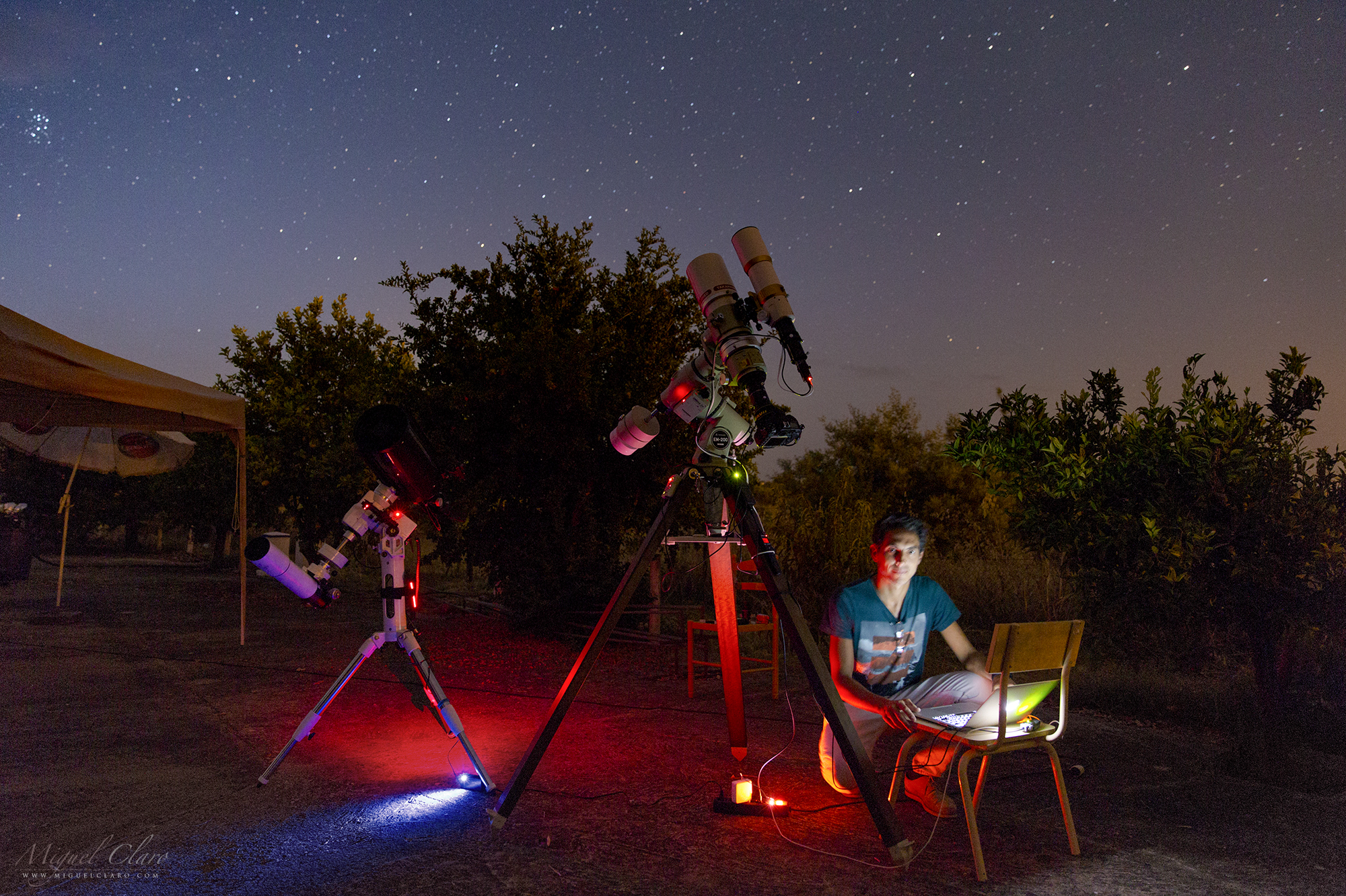
After a night of work under the starry sky of Mourão, in Alqueva Dark Sky® Reserve, a self portrait shows all the equipment necessary for a deep sky session with two different telescopes controlled by a laptop.
PT: Depois de uma noite de trabalho sob o céu estrelado de Mourão, na Reserva Dark Sky® Alqueva, um auto-retrato mostra todo o equipamento necessário para uma sessão de céu profundo com dois telescópios diferentes controlados por um computador portátil.
Zodiacal light in the glacial valley of Glendalough

Zodiacal light and planet Venus in the forest of Glendalough. Meaning “Valley of two lakes”, is a glacial valley in County Wicklow, Ireland, renowned for an Early Medieval monastic settlement founded in the 6th century by St Kevin. It combines extensive monastic ruins with a stunning natural setting in the Wicklow Mountains. The beauty and tranquility of the lakes and glacial-carved valley no doubt appealed to St Kevin, a hermit monk, who founded the monastic site near the Lower Lake in the 6th Century. Most of the buildings that survive today date from the 10th through 12th centuries. Despite attacks by Vikings over the years, Glendalough thrived as one of Irelands great ecclesiastical foundations and schools of learning until the Normans destroyed the monastery in 1214 and the dioceses of Glendalough and Dublin were united. The settlement was destroyed by English forces in 1398. A reconstruction program was started in 1878 and today the valley boasts a visitor centre, wooded trails, walkways and rock climbing. The monastic ruins include a round tower, seven churches, a gateway into the settlement with a Sanctuary Stone, two High Crosses, the priest’s house, a graveyard, Reeferts Church, St. Kevin’s Bed (Cave) and St. Kevin’s Cell (hermitage hut). More about.
PT: Luz zodiacal e o planeta Vénus na floresta de Glendalough. Com o significado “Vale dos dois lagos”, é um vale glacial no condado de Wicklow, na Irlanda, conhecida por uma povoação monástica medieval precoce fundada no século 6 pelo St Kevin. Combina extensas ruínas monásticas com um cenário natural deslumbrante nas montanhas de Wicklow. A beleza e tranquilidade dos lagos e do vale glacial esculpido, sem dúvida, chamaram a atenção do monge eremita St Kevin . A maioria dos edifícios que sobreviveram até aos dias de hoje datam do século 12. Apesar dos ataques de Vikings ao longo dos anos, Glendalough prosperou como uma das grandes fundações eclesiásticas irlandesas e escolas de aprendizagem até que os normandos destruiram o mosteiro em 1214 e as dioceses de Glendalough e Dublin foram unidos. A liquidação foi destruída por forças inglesas em 1398. Um programa de reconstrução foi iniciado em 1878 e hoje o vale dispõe de um centro de visitantes, trilhas arborizadas, calçadas e escalada. As ruínas monásticas incluem uma torre redonda, sete igrejas, uma porta de entrada para a povoação com um Santuário de pedra, duas cruzes celtas altas, casa do padre e um cemitério.
Celtic Cemetery in Glendalough

The Celtic cemetery at Glendalough has spread Celtic crosses and ancient gravestones throughout the area. Finest examples of a plain cross remarkably carved from a single granite stone. The cross is the most ancient and powerful of symbols: an encounter of the vertical with the horizontal, the feminine & masculine, temporal & eternal. The circle of the Celtic cross, implying infinity, gives it a cosmic dimension. The arms of the cross are over a metre in length. The imperforate cross stands about 2.5m tall. It may have marked the boundary of the cemetery in which stands the priests’ house. This cross is a fine example of how St Patrick trying to help the once pagan people of Ireland acclimate to Christianity. This was done by combining the cross with the circle representing the sun, because the pagans worshipped the sun and moon. A local legend surrounding St. Kevin’s Cross says that anyone who can wrap their arms around the entire width of the cross body and close the circle by touching fingertips will have their wishes granted.

Glendalough (meaning “Valley of two lakes”) is a glacial valley in County Wicklow, Ireland, renowned for an Early Medieval monastic settlement founded in the 6th century by St Kevin. It combines extensive monastic ruins with a stunning natural setting in the Wicklow Mountains. The beauty and tranquility of the lakes and glacial-carved valley no doubt appealed to St Kevin, a hermit monk, who founded the monastic site near the Lower Lake in the 6th Century. Most of the buildings that survive today date from the 10th through 12th centuries. Despite attacks by Vikings over the years, Glendalough thrived as one of Irelands great ecclesiastical foundations and schools of learning until the Normans destroyed the monastery in 1214 and the dioceses of Glendalough and Dublin were united. The settlement was destroyed by English forces in 1398. A reconstruction program was started in 1878 and today the valley boasts a visitor centre, wooded trails, walkways and rock climbing. The monastic ruins include a round tower, seven churches, a gateway into the settlement with a Sanctuary Stone, two High Crosses, the priest’s house, a graveyard, Reeferts Church, St. Kevin’s Bed (Cave) and St. Kevin’s Cell (hermitage hut). More about.
PT: Este cemitério em Glendalough tem espalhadas cruzes celtas e lápides anciãs. A cruz celta é um belo exemplo de uma cruz simples notavelmente esculpida de uma única pedra de granito. A cruz é o mais antiga e poderoso símbolo: um encontro do vertical com o horizontal, o feminino e masculino, temporal e eterno. O círculo da cruz celta, o que implica infinito, dá-lhe uma dimensão cósmica. Estas cruzes celtas podem ser encontradas no cemitério de Glendalough. Com o significado “Vale dos dois lagos”, é um vale glacial no condado de Wicklow, na Irlanda, conhecida por uma povoação monástica medieval precoce fundada no século 6 pelo St Kevin. Combina extensas ruínas monásticas com um cenário natural deslumbrante nas montanhas de Wicklow. A beleza e tranquilidade dos lagos e do vale glacial esculpido, sem dúvida, chamaram a atenção do monge eremita St Kevin . A maioria dos edifícios que sobreviveram até aos dias de hoje datam do século 12. Apesar dos ataques de Vikings ao longo dos anos, Glendalough prosperou como uma das grandes fundações eclesiásticas irlandesas e escolas de aprendizagem até que os normandos destruiram o mosteiro em 1214 e as dioceses de Glendalough e Dublin foram unidos. A liquidação foi destruída por forças inglesas em 1398. Um programa de reconstrução foi iniciado em 1878 e hoje o vale dispõe de um centro de visitantes, trilhas arborizadas, calçadas e escalada. As ruínas monásticas incluem uma torre redonda, sete igrejas, uma porta de entrada para a povoação com um Santuário de pedra, duas cruzes celtas altas, casa do padre e um cemitério.

Celtic Cross in Ireland

This Celtic Cross is a fine example of a plain cross remarkably carved from a single granite stone. The cross is the most ancient and powerful of symbols: an encounter of the vertical with the horizontal, the feminine & masculine, temporal & eternal. The circle of the Celtic cross, implying infinity, gives it a cosmic dimension. The arms of the cross are over a meter in length. The imperforate cross stands about 2.5m tall. It may have marked the boundary of the cemetery in which stands the priests’ house. This cross is a fine example of how St Patrick trying to help the once pagan people of Ireland acclimate to Christianity. This was done by combining the cross with the circle representing the sun, because the pagans worshipped the sun and moon. A local legend surrounding St. Kevin’s Cross says that anyone who can wrap their arms around the entire width of the cross body and close the circle by touching fingertips will have their wishes granted.
Glendalough (meaning “Valley of two lakes”) is a glacial valley in County Wicklow, Ireland, renowned for an Early Medieval monastic settlement founded in the 6th century by St Kevin. It combines extensive monastic ruins with a stunning natural setting in the Wicklow Mountains. The beauty and tranquility of the lakes and glacial-carved valley no doubt appealed to St Kevin, a hermit monk, who founded the monastic site near the Lower Lake in the 6th Century. Most of the buildings that survive today date from the 10th through 12th centuries. Despite attacks by Vikings over the years, Glendalough thrived as one of Irelands great ecclesiastical foundations and schools of learning until the Normans destroyed the monastery in 1214 and the dioceses of Glendalough and Dublin were united. The settlement was destroyed by English forces in 1398. A reconstruction program was started in 1878 and today the valley boasts a visitor centre, wooded trails, walkways and rock climbing. The monastic ruins include a round tower, seven churches, a gateway into the settlement with a Sanctuary Stone, two High Crosses, the priest’s house, a graveyard, Reeferts Church, St. Kevin’s Bed (Cave) and St. Kevin’s Cell (hermitage hut). More about.
PT: Esta cruz celta é um belo exemplo de uma cruz simples notavelmente esculpida de uma única pedra de granito. A cruz é o mais antiga e poderoso símbolo: um encontro do vertical com o horizontal, o feminino e masculino, temporal e eterno. O círculo da cruz celta, o que implica infinito, dá-lhe uma dimensão cósmica. Estas cruzes celtas podem ser encontradas no cemitério de Glendalough. Com o significado “Vale dos dois lagos”, é um vale glacial no condado de Wicklow, na Irlanda, conhecida por uma povoação monástica medieval precoce fundada no século 6 pelo St Kevin. Combina extensas ruínas monásticas com um cenário natural deslumbrante nas montanhas de Wicklow. A beleza e tranquilidade dos lagos e do vale glacial esculpido, sem dúvida, chamaram a atenção do monge eremita St Kevin . A maioria dos edifícios que sobreviveram até aos dias de hoje datam do século 12. Apesar dos ataques de Vikings ao longo dos anos, Glendalough prosperou como uma das grandes fundações eclesiásticas irlandesas e escolas de aprendizagem até que os normandos destruiram o mosteiro em 1214 e as dioceses de Glendalough e Dublin foram unidos. A liquidação foi destruída por forças inglesas em 1398. Um programa de reconstrução foi iniciado em 1878 e hoje o vale dispõe de um centro de visitantes, trilhas arborizadas, calçadas e escalada. As ruínas monásticas incluem uma torre redonda, sete igrejas, uma porta de entrada para a povoação com um Santuário de pedra, duas cruzes celtas altas, casa do padre e um cemitério.
Celtic Cross Against the Night Sky
This Celtic Cross is a fine example of a plain cross remarkably carved from a single granite stone. The cross is the most ancient and powerful of symbols: an encounter of the vertical with the horizontal, the feminine & masculine, temporal & eternal. The circle of the Celtic cross, implying infinity, gives it a cosmic dimension. The arms of the cross are over a metre in length. The imperforate cross stands about 2.5m tall. It may have marked the boundary of the cemetery in which stands the priests’ house. This cross is a fine example of how St Patrick trying to help the once pagan people of Ireland acclimate to Christianity. This was done by combining the cross with the circle representing the sun, because the pagans worshipped the sun and moon. A local legend surrounding St. Kevin’s Cross says that anyone who can wrap their arms around the entire width of the cross body and close the circle by touching fingertips will have their wishes granted.
Glendalough (meaning “Valley of two lakes”) is a glacial valley in County Wicklow, Ireland, renowned for an Early Medieval monastic settlement founded in the 6th century by St Kevin. It combines extensive monastic ruins with a stunning natural setting in the Wicklow Mountains. The beauty and tranquility of the lakes and glacial-carved valley no doubt appealed to St Kevin, a hermit monk, who founded the monastic site near the Lower Lake in the 6th Century. Most of the buildings that survive today date from the 10th through 12th centuries. Despite attacks by Vikings over the years, Glendalough thrived as one of Irelands great ecclesiastical foundations and schools of learning until the Normans destroyed the monastery in 1214 and the dioceses of Glendalough and Dublin were united. The settlement was destroyed by English forces in 1398. A reconstruction program was started in 1878 and today the valley boasts a visitor centre, wooded trails, walkways and rock climbing. The monastic ruins include a round tower, seven churches, a gateway into the settlement with a Sanctuary Stone, two High Crosses, the priest’s house, a graveyard, Reeferts Church, St. Kevin’s Bed (Cave) and St. Kevin’s Cell (hermitage hut). More about.
PT: Esta cruz celta é um belo exemplo de uma cruz simples notavelmente esculpida de uma única pedra de granito. A cruz é o mais antiga e poderoso símbolo: um encontro do vertical com o horizontal, o feminino e masculino, temporal e eterno. O círculo da cruz celta, o que implica infinito, dá-lhe uma dimensão cósmica. Estas cruzes celtas podem ser encontradas no cemitério de Glendalough. Com o significado “Vale dos dois lagos”, é um vale glacial no condado de Wicklow, na Irlanda, conhecida por uma povoação monástica medieval precoce fundada no século 6 pelo St Kevin. Combina extensas ruínas monásticas com um cenário natural deslumbrante nas montanhas de Wicklow. A beleza e tranquilidade dos lagos e do vale glacial esculpido, sem dúvida, chamaram a atenção do monge eremita St Kevin . A maioria dos edifícios que sobreviveram até aos dias de hoje datam do século 12. Apesar dos ataques de Vikings ao longo dos anos, Glendalough prosperou como uma das grandes fundações eclesiásticas irlandesas e escolas de aprendizagem até que os normandos destruiram o mosteiro em 1214 e as dioceses de Glendalough e Dublin foram unidos. A liquidação foi destruída por forças inglesas em 1398. Um programa de reconstrução foi iniciado em 1878 e hoje o vale dispõe de um centro de visitantes, trilhas arborizadas, calçadas e escalada. As ruínas monásticas incluem uma torre redonda, sete igrejas, uma porta de entrada para a povoação com um Santuário de pedra, duas cruzes celtas altas, casa do padre e um cemitério.
If the Shadows Were Roots

EN: This full dome view show a blue sky filled with winter stars like Sirius or bright constellations like Orion, is illuminated by the Moonlight working as a perfect background to highlight the silhouette from the Giant Chestnut tree of Guilhafonso in Guarda, Portugal, while in the field, its projection creates the illusion like if the shadows were roots. This century-old tree is considered the largest of its kind in Europe. This is a specimen of 9.60 meters trunk circumference, 19 meters in height, average crown diameter of 25.5 meters and an estimated age of over 400 years. Residents ensure that they need at least nine people to embrace its trunk. In 2015 the giant chestnut won new liveliness after having been treated which allowed it to still giving chestnuts nowadays.
PT: Nesta imagem All Sky, um céu azul repleto de estrelas de inverno como Sirius ou constelações brilhantes como Orion, é iluminado pelo luar funcionando como o pano de fundo perfeito para destacar a imponente silhueta do Castanheiro Gigante de Guilhafonso, na Guarda, Portugal, enquanto a projecção das sombras em terra nos dá a ilusão como se as mesmas fossem as suas próprias raízes. Esta árvore centenária é considerada a maior da sua espécie na Europa. Trata-se de um espécime de 9,60 metros de perímetro de tronco, 19 metros de altura, diâmetro médio da copa de 25,5 metros e uma idade estimada em mais de 400 anos. Os residentes garantem que são precisas pelo menos nove pessoas para abraçar o seu tronco. Em 2015, depois de ter sido submetido a um tratamento, o castanheiro gigante ganhou nova vivacidade o que permitiu continuar dar nozes até aos dias de hoje.
The Giant Chestnut of Guilhafonso

EN: A blue sky filled with winter stars like Sirius or bright constellations like Orion, is illuminated by the Moonlight working as a perfect background to highlight the silhouette from the Giant Chestnut tree of Guilhafonso in Guarda, Portugal. This century-old tree is considered the largest of its kind in Europe. This is a specimen of 9.60 meters trunk circumference, 19 meters in height, average crown diameter of 25.5 meters and an estimated age of over 400 years. Residents ensure that they need at least nine people to embrace its trunk. In 2015 the giant chestnut won new liveliness after having been treated which allowed it to still giving chestnuts nowadays.
PT: Um céu azul repleto de estrelas de inverno como Sirius ou constelações brilhantes como Orion, é iluminada pelo luar funcionando como o pano de fundo perfeito para destacar a imponente silhueta do Castanheiro Gigante de Guilhafonso, na Guarda, Portugal. Esta árvore centenária é considerada a maior da sua espécie na Europa. Trata-se de um espécime de 9,60 metros de perímetro de tronco, 19 metros de altura, diâmetro médio da copa de 25,5 metros e uma idade estimada em mais de 400 anos. Os residentes garantem que são precisas pelo menos nove pessoas para abraçar o seu tronco. Em 2015, depois de ter sido submetido a um tratamento, o castanheiro gigante ganhou nova vivacidade o que permitiu continuar dar nozes até aos dias de hoje.
Venus Reflecting on Causeway Coast of Northern Ireland

Venus is the second-brightest natural object in the night sky after the Moon, reaching an apparent magnitude of −4.6, bright enough to cast shadows. Is the second planet from the Sun, orbiting it every 224.7 Earth days. It has the longest rotation period (243 days) of any planet in the Solar System and rotates in the opposite direction to most other planets. It has no natural satellite. It is named after the Roman goddess of love and beauty. Normally visible at Dawn or other times at Dusk, Venus has been a major fixture in human culture for as long as records have existed. It has been made sacred to gods of many cultures, and has been a prime inspiration for writers and poets as the “morning star” and “evening star”. In the image above, the brightness of this planet is reflecting in the ocean surface from Causeway Coast in Northern Ireland, due to a presence of tiny water droplets in thin clouds – which diffract the light of bright heavenly bodies working as a natural diffuse filter – we also can see a blueish color from its corona. The Giant’s Causeway is an area of about 40,000 interlocking basalt columns, the result of an ancient volcanic eruption. It is located in County Antrim on the northeast coast of Northern Ireland, about three miles (4.8 km) northeast of the town of Bushmills. It was declared a World Heritage Site by UNESCO in 1986, and a national nature reserve in 1987 by the Department of the Environment for Northern Ireland.
Dreaming Sphere

A path of light illuminates our land on Earth, but in the same way, a light cloud of gas and dust is shining bright and high in the sky of this full dome view. In the foreground, a dead tree is standing below the gigantic arc of our galaxy, the Milky Way. This “dreaming sphere” was captured in Noudar Park, Alqueva Dark Sky® Reserve, Barrancos.
PT: Um caminho de luz ilumina a Terra, enquanto simultaneamente uma nuvem luminosa de gás e poeira cósmica brilha alto no céu desta visão “full dome”. Em primeiro plano, uma árvore morta mantém-se erguida abaixo do gigantesco arco galáctico da Via Láctea. Esta “esfera de sonhos” foi captada no Parque de Natureza de Noudar, em Barrancos, na Reserva Dark Sky® Alqueva.
Milky Way above Trees in São Pedro de Atacama

Central region of Milky Way above the trees of a farm from the small desert village of São Pedro de Atacama. Chile – October 2015.
PT: Região Central da Via Láctea acima das árvores de uma quinta na vila de São Pedro de Atacama. Chile. Outubro 2015
Milky Way and Magellanic Clouds above São Pedro de Atacama

Milky Way arc with Zodiacal Light above a farm from the small desert village of São Pedro de Atacama. In the left part of this panoramic view, is also visible the Canopus star rising above the horizon and the Large (LMC) and Small (SMC) Magellanic clouds shining high in the sky of Chile – October 2015.
PT: O arco da Via Láctea e a Luz Zodiacal acima de uma quinta na vila de São Pedro de Atacama. À esquerda, a estrela Canopus nasce acima do horizonte, e logo acima desta, erguem-se a grande (LMC) e pequena (SMC) Nuvem de Magalhães – galáxias satélite da Via Láctea – visíveis a olho nu, brilham intensamente nos céus do Chile. Outubro 2015
Perseids in Noudar Park

Some meteors from Perseids shower captured one week before the peak predicted to 12 August, above the landscape of Noudar Park, in Alqueva Dark Sky® Reserve, Barrancos. In the foreground an Olive Tree is at the left side of Milky Way.
PT: Alguns meteoros captados uma semana antes do pico máximo da chuva de estrelas anual das Perseidas, previsto para 12 de Agosto. Acima deles, é possível ver o céu do Parque de Natureza de Noudar, em Barrancos, Reserva Dark Sky® Alqueva. No primeiro plano, uma oliveira destaca-se do horizonte à esquerda da imponente presença da Via Láctea.
Lightning Storm during Full Moon in Dominican Republic

While the Full Moon of June was rising above the clouds, a Lightning Storm has spread in the sky of Punta Cana, Dominican Republic. In the foreground, a group of coconut trees is standing up while resists to the wild power of nature, with strong winds, humidity and the danger of a falling thunderbolt.
PT: Enquanto a Lua cheia de junho nasce acima das nuvens, uma tempestade de relâmpagos rapidamente se espalha nos céus de Punta Cana, na República Dominicana. Em primeiro plano, um grupo de coqueiros mantém-se firme de pé, enquanto resiste ao poder selvagem da natureza, com ventos fortes, humidade muito elevada e o perigo iminente de um raio se precipitar sobre eles.
Milky Way above Valle de la Muerte in Chile

Milky Way and Zodiacal Light captured after the nautical twilight above Valle de la Muerte, in la Cordillera De La Sal, near San Pedro de Atacama, Chile – October 2015.
PT: Via Láctea e a Luz Zodiacal captada a seguir ao crepúsculo náutico acima do Vale da Morte, na cordilheira De La Sal, próxima a São Pedro de Atacama, no Chile. Outubro 2015
Bridge of Light – Connecting worlds, realities and dimensions

EN: A bridge could be a connection of two worlds, realities or dimensions, or simply two sides of lake as we can see on the image, but in a figurative sense, could also be a word that simbolizes a “perfect connection” between pristine and modern, the night sky and the landscape of our beautiful planet in suspension among the arm of gas and dust from our galaxy, the Milky Way. Reflected in the calm water of the largest manmade lake in Europe (250Km²) are the light of a slowly lonely car that took several seconds to cross the entire bridge. But also the light of the stars, which took hundred or millions of years at a speed of light to reach this particular point, ready to be recorded in this singular picture taken from one of the rare Dark Sky places on Earth, in Mourão, Alqueva Dark Sky Reserve.
PT: Uma ponte pode ser a conexão de dois mundos, realidades ou dimensões, ou simplesmente a ligação a duas margens de um lago. Em sentido figurado, também pode ser uma palavra que simboliza uma “conexão perfeita” entre o Prístino e o Moderno, o céu noturno e a paisagem do nosso belo planeta em suspensão entre o braço de gás e poeira cósmica da nossa galáxia, a Via Láctea. Refletida na água calma do maior lago artificial da Europa (250Km²), está não só a luz de um carro lento e solitário que levou vários segundos para completar a travessia desta ponte e gravar o seu trajecto no espelho de água do Alqueva, como também o brilho das estrelas que levou dezenas, centenas e milhares de anos a percorrer numa viajem à velocidade da luz, a distância que nos separa no longínquo vácuo Interestelar. Aqui ficaram registadas as impressões de luz de uma viagem no tempo e no espaço, na história da própria Terra, do próprio Homem, um ser inteligente mas ainda recente na cronologia da vida deste Universo, que nesta imagem singular nos é revelado em perfeita harmonia e sintonia com a natureza que nos rodeia, num dos raros lugares da Terra onde o céu da antiguidade, ainda pode ser apreciado, partilhado e lembrado. Mourão, Dark Sky® Alqueva.
Ursa Major & Ursa Minor above the Ruins of Roman City Ammaia

EN: The northern constellations Ursa Major (Big Dipper) and Ursa Minor – in a diffuse vision by a passing cloud – as seen from inside the remaining ruins of the Southern Gate Tower of the Roman City of Ammaia.
The Gradual consolidation of Roman power led to the establishment of a substantial Roman town in the 1st century. Ammaia occupied up to 25 hectares, and with a population exceeding modern-day Marvão (5000-6000 inhabitants) Ammaia occupied the site of the present-day parish of São Salvador da Aramenha. The town flourished between the 1st century BCE and the collapse of the Roman Empire in the 5th century CE. Roman Ammaia saw the development of improved irrigation and terracing across the Marvão mountain. Chestnut cultivation – Replacing the place dominance of oak is likely to have been introduced at this time. Much of the terracing and ancient watercourses on the mountain Marvão date from this era.
Limited excavations at Ammaia in the past two decades covering a mere 3,000 m2 (32.292 sq ft) of the town’s area – have revealed the success, provincial expanding town that included running water, a forum, baths, the bridge over the river Sever (near today’s ‘Old Bridge’), and monumental gates (one gate was removed to Castelo de Vide in the 18th century, yet sadly dynamited in 1890). The Alentejo region, meanwhile, was criss-crossed with efficient Roman roads, providing links to the wider Empire. Fine wares found at the site Ammaia suggest que Ammaia nobility had access to luxury glassware and jewelery, while archeology has Revealed that marble for the forum was imported from across the Empire. The high quality, for example, of the ‘Mosaic of the Muses’ from a Roman villa in nearby Monforte (4th century BCE) points to the abundant riches to be made to an Alentejo landowner in the Roman era. Sadly, many artifacts from Ammaia in particular the series of marble sculptures were removed during the 19th and 20th centuries, notably by the Anglo-Portuguese Robinson family. These items are now in collections such as those of the British Museum..
Many of the excavations were concentrated over the obvious ruins or where there was evidence of subterranean structures associated with a Roman presence. Discoveries include parts of a Roman city wall with towers and a gate on the south side, with residenctial buildings; a road; a monumental paved square; remains of a house in the location Quinta do Deão; parts of a public bath building; and a centrally-located forum with well-preserved temple podium, walls of a porticus and cryptoporticus. The town plan follows a regular rectangular layout organized along two main perpendicular street axes, linking the central forum to its main gates. A city wall surrounds a roughly rectangular area of some 20 hectares. Several extramural buildings, cemeteries and roads constitute the suburban area.
PT: As constelações do norte, Ursa Maior e Ursa Menor, numa visão difusa através de uma nuvem passageira, vistas a partir das imponentes ruínas da Porta Sul da cidade Romana da Ammaia. A Cidade de Ammaia é indubitavelmente o mais importante vestígio da sua época existente na região do norte alentejano. Localizada em pleno Parque Natural da Serra de São Mamede, em São Salvador de Aramenha, no concelho de Marvão, a sua área central é constituída pela Quinta do Deão e pela Tapada da Aramenha, possuindo uma área de aproximadamente 25 ha.
Embora as suas ruínas tivessem sido classificadas como Monumento Nacional em 1949, estiveram abandonadas até finais de 1994. A partir desta data e com o aparecimento da Fundação Cidade de Ammaia vêm-se desenvolvendo todos os esforços no sentido de estudar e preservar o que resta desta importante cidade. Ammaia foi elevada a Civitas por volta do ano 44/45 d.C. tendo obtido o estatuto de Mvnicipivm ainda durante o séc. I d.C., no entanto apenas temos dados sobre o mesmo no reinado de Lúcio Vero, no ano de 166 d.C.
A Northern Starry Trail from inside the Southern Gate of the Roman City of Ammaia

EN: A Polar Startrail from inside the remaining ruins of the Southern Gate Tower of the Roman City of Ammaia.
The Gradual consolidation of Roman power led to the establishment of a substantial Roman town in the 1st century. Ammaia occupied up to 25 hectares, and with a population exceeding modern-day Marvão (5000-6000 inhabitants) Ammaia occupied the site of the present-day parish of São Salvador da Aramenha. The town flourished between the 1st century BCE and the collapse of the Roman Empire in the 5th century CE. Roman Ammaia saw the development of improved irrigation and terracing across the Marvão mountain. Chestnut cultivation – Replacing the place dominance of oak is likely to have been introduced at this time. Much of the terracing and ancient watercourses on the mountain Marvão date from this era.
Limited excavations at Ammaia in the past two decades covering a mere 3,000 m2 (32.292 sq ft) of the town’s area – have revealed the success, provincial expanding town that included running water, a forum, baths, the bridge over the river Sever (near today’s ‘Old Bridge’), and monumental gates (one gate was removed to Castelo de Vide in the 18th century, yet sadly dynamited in 1890). The Alentejo region, meanwhile, was criss-crossed with efficient Roman roads, providing links to the wider Empire. Fine wares found at the site Ammaia suggest que Ammaia nobility had access to luxury glassware and jewelery, while archeology has Revealed that marble for the forum was imported from across the Empire. The high quality, for example, of the ‘Mosaic of the Muses’ from a Roman villa in nearby Monforte (4th century BCE) points to the abundant riches to be made to an Alentejo landowner in the Roman era. Sadly, many artifacts from Ammaia in particular the series of marble sculptures were removed during the 19th and 20th centuries, notably by the Anglo-Portuguese Robinson family. These items are now in collections such as those of the British Museum..
Many of the excavations were concentrated over the obvious ruins or where there was evidence of subterranean structures associated with a Roman presence. Discoveries include parts of a Roman city wall with towers and a gate on the south side, with residenctial buildings; a road; a monumental paved square; remains of a house in the location Quinta do Deão; parts of a public bath building; and a centrally-located forum with well-preserved temple podium, walls of a porticus and cryptoporticus. The town plan follows a regular rectangular layout organized along two main perpendicular street axes, linking the central forum to its main gates. A city wall surrounds a roughly rectangular area of some 20 hectares. Several extramural buildings, cemeteries and roads constitute the suburban area.
PT: Um vórtice de luz estrelar em torno da estrela Polar, a partir das imponentes ruínas da Porta Sul da cidade Romana da Ammaia. A Cidade de Ammaia é indubitavelmente o mais importante vestígio da sua época existente na região do norte alentejano. Localizada em pleno Parque Natural da Serra de São Mamede, em São Salvador de Aramenha, no concelho de Marvão, a sua área central é constituída pela Quinta do Deão e pela Tapada da Aramenha, possuindo uma área de aproximadamente 25 ha.
Embora as suas ruínas tivessem sido classificadas como Monumento Nacional em 1949, estiveram abandonadas até finais de 1994. A partir desta data e com o aparecimento da Fundação Cidade de Ammaia vêm-se desenvolvendo todos os esforços no sentido de estudar e preservar o que resta desta importante cidade. Ammaia foi elevada a Civitas por volta do ano 44/45 d.C. tendo obtido o estatuto de Mvnicipivm ainda durante o séc. I d.C., no entanto apenas temos dados sobre o mesmo no reinado de Lúcio Vero, no ano de 166 d.C.
Moon and Venus above the Ruins of Roman City Ammaia

EN: One of the remaining ruins from the Southern Gate Tower of the Roman City of Ammaia, in a cloudy moonlight scene. At the right side of the moon it is visible the planet Venus.
The Gradual consolidation of Roman power led to the establishment of a substantial Roman town in the 1st century. Ammaia occupied up to 25 hectares, and with a population exceeding modern-day Marvão (5000-6000 inhabitants) Ammaia occupied the site of the present-day parish of São Salvador da Aramenha. The town flourished between the 1st century BCE and the collapse of the Roman Empire in the 5th century CE. Roman Ammaia saw the development of improved irrigation and terracing across the Marvão mountain. Chestnut cultivation – Replacing the place dominance of oak is likely to have been introduced at this time. Much of the terracing and ancient watercourses on the mountain Marvão date from this era.
Limited excavations at Ammaia in the past two decades covering a mere 3,000 m2 (32.292 sq ft) of the town’s area – have revealed the success, provincial expanding town that included running water, a forum, baths, the bridge over the river Sever (near today’s ‘Old Bridge’), and monumental gates (one gate was removed to Castelo de Vide in the 18th century, yet sadly dynamited in 1890). The Alentejo region, meanwhile, was criss-crossed with efficient Roman roads, providing links to the wider Empire. Fine wares found at the site Ammaia suggest que Ammaia nobility had access to luxury glassware and jewelery, while archeology has Revealed that marble for the forum was imported from across the Empire. The high quality, for example, of the ‘Mosaic of the Muses’ from a Roman villa in nearby Monforte (4th century BCE) points to the abundant riches to be made to an Alentejo landowner in the Roman era. Sadly, many artifacts from Ammaia in particular the series of marble sculptures were removed during the 19th and 20th centuries, notably by the Anglo-Portuguese Robinson family. These items are now in collections such as those of the British Museum..
Many of the excavations were concentrated over the obvious ruins or where there was evidence of subterranean structures associated with a Roman presence. Discoveries include parts of a Roman city wall with towers and a gate on the south side, with residenctial buildings; a road; a monumental paved square; remains of a house in the location Quinta do Deão; parts of a public bath building; and a centrally-located forum with well-preserved temple podium, walls of a porticus and cryptoporticus. The town plan follows a regular rectangular layout organized along two main perpendicular street axes, linking the central forum to its main gates. A city wall surrounds a roughly rectangular area of some 20 hectares. Several extramural buildings, cemeteries and roads constitute the suburban area.
PT: Uma noite de luar envolta na neblina que circunda as importantes e imponentes ruínas da Porta Sul da cidade Romana da Ammaia. Logo abaixo da Lua, é ainda possível ver o brilho arrastado do planeta Vénus. A Cidade de Ammaia é indubitavelmente o mais importante vestígio da sua época existente na região do norte alentejano. Localizada em pleno Parque Natural da Serra de São Mamede, em São Salvador de Aramenha, no concelho de Marvão, a sua área central é constituída pela Quinta do Deão e pela Tapada da Aramenha, possuindo uma área de aproximadamente 25 ha.
Embora as suas ruínas tivessem sido classificadas como Monumento Nacional em 1949, estiveram abandonadas até finais de 1994. A partir desta data e com o aparecimento da Fundação Cidade de Ammaia vêm-se desenvolvendo todos os esforços no sentido de estudar e preservar o que resta desta importante cidade. Ammaia foi elevada a Civitas por volta do ano 44/45 d.C. tendo obtido o estatuto de Mvnicipivm ainda durante o séc. I d.C., no entanto apenas temos dados sobre o mesmo no reinado de Lúcio Vero, no ano de 166 d.C.
The Monumental Paved Square from Roman City of Ammaia

EN: One of the remaining ruins from the monumental paved square of the Roman City of Ammaia, in a cloudy moonlight scene. Venus is the bright diffuse light below the right side of the moon.
The Gradual consolidation of Roman power led to the establishment of a substantial Roman town in the 1st century. Ammaia occupied up to 25 hectares, and with a population exceeding modern-day Marvão (5000-6000 inhabitants) Ammaia occupied the site of the present-day parish of São Salvador da Aramenha. The town flourished between the 1st century BCE and the collapse of the Roman Empire in the 5th century CE. Roman Ammaia saw the development of improved irrigation and terracing across the Marvão mountain. Chestnut cultivation – Replacing the place dominance of oak is likely to have been introduced at this time. Much of the terracing and ancient watercourses on the mountain Marvão date from this era.
Limited excavations at Ammaia in the past two decades covering a mere 3,000 m2 (32.292 sq ft) of the town’s area – have revealed the success, provincial expanding town that included running water, a forum, baths, the bridge over the river Sever (near today’s ‘Old Bridge’), and monumental gates (one gate was removed to Castelo de Vide in the 18th century, yet sadly dynamited in 1890). The Alentejo region, meanwhile, was criss-crossed with efficient Roman roads, providing links to the wider Empire. Fine wares found at the site Ammaia suggest que Ammaia nobility had access to luxury glassware and jewelery, while archeology has Revealed that marble for the forum was imported from across the Empire. The high quality, for example, of the ‘Mosaic of the Muses’ from a Roman villa in nearby Monforte (4th century BCE) points to the abundant riches to be made to an Alentejo landowner in the Roman era. Sadly, many artifacts from Ammaia in particular the series of marble sculptures were removed during the 19th and 20th centuries, notably by the Anglo-Portuguese Robinson family. These items are now in collections such as those of the British Museum..
Many of the excavations were concentrated over the obvious ruins or where there was evidence of subterranean structures associated with a Roman presence. Discoveries include parts of a Roman city wall with towers and a gate on the south side, with residenctial buildings; a road; a monumental paved square; remains of a house in the location Quinta do Deão; parts of a public bath building; and a centrally-located forum with well-preserved temple podium, walls of a porticus and cryptoporticus. The town plan follows a regular rectangular layout organized along two main perpendicular street axes, linking the central forum to its main gates. A city wall surrounds a roughly rectangular area of some 20 hectares. Several extramural buildings, cemeteries and roads constitute the suburban area.
PT: Uma noite de luar envolta na neblina que circunda as imponentes ruínas da praça pública pavimentada com blocos de granito, da cidade Romana da Ammaia. À direita da Lua, é possível ver o brilho difuso do planeta Vénus. A Cidade de Ammaia é indubitavelmente o mais importante vestígio da sua época existente na região do norte alentejano. Localizada em pleno Parque Natural da Serra de São Mamede, em São Salvador de Aramenha, no concelho de Marvão, a sua área central é constituída pela Quinta do Deão e pela Tapada da Aramenha, possuindo uma área de aproximadamente 25 ha.
Embora as suas ruínas tivessem sido classificadas como Monumento Nacional em 1949, estiveram abandonadas até finais de 1994. A partir desta data e com o aparecimento da Fundação Cidade de Ammaia vêm-se desenvolvendo todos os esforços no sentido de estudar e preservar o que resta desta importante cidade. Ammaia foi elevada a Civitas por volta do ano 44/45 d.C. tendo obtido o estatuto de Mvnicipivm ainda durante o séc. I d.C., no entanto apenas temos dados sobre o mesmo no reinado de Lúcio Vero, no ano de 166 d.C.
The Starry Sky from Roman City of Ammaia

EN: One of the remaining ruins from the Southern Gate Tower of the Roman City of Ammaia, in a cloudy moonlight scene.
The Gradual consolidation of Roman power led to the establishment of a substantial Roman town in the 1st century. Ammaia occupied up to 25 hectares, and with a population exceeding modern-day Marvão (5000-6000 inhabitants) Ammaia occupied the site of the present-day parish of São Salvador da Aramenha. The town flourished between the 1st century BCE and the collapse of the Roman Empire in the 5th century CE. Roman Ammaia saw the development of improved irrigation and terracing across the Marvão mountain. Chestnut cultivation – Replacing the place dominance of oak is likely to have been introduced at this time. Much of the terracing and ancient watercourses on the mountain Marvão date from this era.
Limited excavations at Ammaia in the past two decades covering a mere 3,000 m2 (32.292 sq ft) of the town’s area – have revealed the success, provincial expanding town that included running water, a forum, baths, the bridge over the river Sever (near today’s ‘Old Bridge’), and monumental gates (one gate was removed to Castelo de Vide in the 18th century, yet sadly dynamited in 1890). The Alentejo region, meanwhile, was criss-crossed with efficient Roman roads, providing links to the wider Empire. Fine wares found at the site Ammaia suggest que Ammaia nobility had access to luxury glassware and jewelery, while archeology has Revealed that marble for the forum was imported from across the Empire. The high quality, for example, of the ‘Mosaic of the Muses’ from a Roman villa in nearby Monforte (4th century BCE) points to the abundant riches to be made to an Alentejo landowner in the Roman era. Sadly, many artifacts from Ammaia in particular the series of marble sculptures were removed during the 19th and 20th centuries, notably by the Anglo-Portuguese Robinson family. These items are now in collections such as those of the British Museum..
Many of the excavations were concentrated over the obvious ruins or where there was evidence of subterranean structures associated with a Roman presence. Discoveries include parts of a Roman city wall with towers and a gate on the south side, with residenctial buildings; a road; a monumental paved square; remains of a house in the location Quinta do Deão; parts of a public bath building; and a centrally-located forum with well-preserved temple podium, walls of a porticus and cryptoporticus. The town plan follows a regular rectangular layout organized along two main perpendicular street axes, linking the central forum to its main gates. A city wall surrounds a roughly rectangular area of some 20 hectares. Several extramural buildings, cemeteries and roads constitute the suburban area.

PT: Uma noite de luar envolta na neblina que circunda as importantes e imponentes ruínas da Porta Sul da cidade Romana da Ammaia. A Cidade de Ammaia é indubitavelmente o mais importante vestígio da sua época existente na região do norte alentejano. Localizada em pleno Parque Natural da Serra de São Mamede, em São Salvador de Aramenha, no concelho de Marvão, a sua área central é constituída pela Quinta do Deão e pela Tapada da Aramenha, possuindo uma área de aproximadamente 25 ha.
Embora as suas ruínas tivessem sido classificadas como Monumento Nacional em 1949, estiveram abandonadas até finais de 1994. A partir desta data e com o aparecimento da Fundação Cidade de Ammaia vêm-se desenvolvendo todos os esforços no sentido de estudar e preservar o que resta desta importante cidade. Ammaia foi elevada a Civitas por volta do ano 44/45 d.C. tendo obtido o estatuto de Mvnicipivm ainda durante o séc. I d.C., no entanto apenas temos dados sobre o mesmo no reinado de Lúcio Vero, no ano de 166 d.C.
ISS Crossing the Skies of the Roman City Ammaia

EN: One of the remaining ruins from the Southern Gate Tower of the Roman City of Ammaia, in a cloudy moonlight scene, during the passage of the International Space Station above the skies. At the right side of the moon it is visible the planet Venus.
The Gradual consolidation of Roman power led to the establishment of a substantial Roman town in the 1st century. Ammaia occupied up to 25 hectares, and with a population exceeding modern-day Marvão (5000-6000 inhabitants) Ammaia occupied the site of the present-day parish of São Salvador da Aramenha. The town flourished between the 1st century BCE and the collapse of the Roman Empire in the 5th century CE. Roman Ammaia saw the development of improved irrigation and terracing across the Marvão mountain. Chestnut cultivation – Replacing the place dominance of oak is likely to have been introduced at this time. Much of the terracing and ancient watercourses on the mountain Marvão date from this era.
Limited excavations at Ammaia in the past two decades covering a mere 3,000 m2 (32.292 sq ft) of the town’s area – have revealed the success, provincial expanding town that included running water, a forum, baths, the bridge over the river Sever (near today’s ‘Old Bridge’), and monumental gates (one gate was removed to Castelo de Vide in the 18th century, yet sadly dynamited in 1890). The Alentejo region, meanwhile, was criss-crossed with efficient Roman roads, providing links to the wider Empire. Fine wares found at the site Ammaia suggest que Ammaia nobility had access to luxury glassware and jewelery, while archeology has Revealed that marble for the forum was imported from across the Empire. The high quality, for example, of the ‘Mosaic of the Muses’ from a Roman villa in nearby Monforte (4th century BCE) points to the abundant riches to be made to an Alentejo landowner in the Roman era. Sadly, many artifacts from Ammaia in particular the series of marble sculptures were removed during the 19th and 20th centuries, notably by the Anglo-Portuguese Robinson family. These items are now in collections such as those of the British Museum..
Many of the excavations were concentrated over the obvious ruins or where there was evidence of subterranean structures associated with a Roman presence. Discoveries include parts of a Roman city wall with towers and a gate on the south side, with residenctial buildings; a road; a monumental paved square; remains of a house in the location Quinta do Deão; parts of a public bath building; and a centrally-located forum with well-preserved temple podium, walls of a porticus and cryptoporticus. The town plan follows a regular rectangular layout organized along two main perpendicular street axes, linking the central forum to its main gates. A city wall surrounds a roughly rectangular area of some 20 hectares. Several extramural buildings, cemeteries and roads constitute the suburban area.
PT: Uma noite de luar envolta na neblina que circunda as importantes e imponentes ruínas da Porta Sul da cidade Romana da Ammaia, enquanto a Estação Espacial Internacional atravessa os céus da região. Logo abaixo da Lua, é ainda possível ver o brilho arrastado do planeta Vénus. A Cidade de Ammaia é indubitavelmente o mais importante vestígio da sua época existente na região do norte alentejano. Localizada em pleno Parque Natural da Serra de São Mamede, em São Salvador de Aramenha, no concelho de Marvão, a sua área central é constituída pela Quinta do Deão e pela Tapada da Aramenha, possuindo uma área de aproximadamente 25 ha.
Embora as suas ruínas tivessem sido classificadas como Monumento Nacional em 1949, estiveram abandonadas até finais de 1994. A partir desta data e com o aparecimento da Fundação Cidade de Ammaia vêm-se desenvolvendo todos os esforços no sentido de estudar e preservar o que resta desta importante cidade. Ammaia foi elevada a Civitas por volta do ano 44/45 d.C. tendo obtido o estatuto de Mvnicipivm ainda durante o séc. I d.C., no entanto apenas temos dados sobre o mesmo no reinado de Lúcio Vero, no ano de 166 d.C.
Ruins from the Roman City of Ammaia

EN: One of the remaining ruins from the Southern Gate Tower of the Roman City of Ammaia, in a cloudy moonlight scene.
The Gradual consolidation of Roman power led to the establishment of a substantial Roman town in the 1st century. Ammaia occupied up to 25 hectares, and with a population exceeding modern-day Marvão (5000-6000 inhabitants) Ammaia occupied the site of the present-day parish of São Salvador da Aramenha. The town flourished between the 1st century BCE and the collapse of the Roman Empire in the 5th century CE. Roman Ammaia saw the development of improved irrigation and terracing across the Marvão mountain. Chestnut cultivation – Replacing the place dominance of oak is likely to have been introduced at this time. Much of the terracing and ancient watercourses on the mountain Marvão date from this era.
Limited excavations at Ammaia in the past two decades covering a mere 3,000 m2 (32.292 sq ft) of the town’s area – have revealed the success, provincial expanding town that included running water, a forum, baths, the bridge over the river Sever (near today’s ‘Old Bridge’), and monumental gates (one gate was removed to Castelo de Vide in the 18th century, yet sadly dynamited in 1890). The Alentejo region, meanwhile, was criss-crossed with efficient Roman roads, providing links to the wider Empire. Fine wares found at the site Ammaia suggest que Ammaia nobility had access to luxury glassware and jewelery, while archeology has Revealed that marble for the forum was imported from across the Empire. The high quality, for example, of the ‘Mosaic of the Muses’ from a Roman villa in nearby Monforte (4th century BCE) points to the abundant riches to be made to an Alentejo landowner in the Roman era. Sadly, many artifacts from Ammaia in particular the series of marble sculptures were removed during the 19th and 20th centuries, notably by the Anglo-Portuguese Robinson family. These items are now in collections such as those of the British Museum..
Many of the excavations were concentrated over the obvious ruins or where there was evidence of subterranean structures associated with a Roman presence. Discoveries include parts of a Roman city wall with towers and a gate on the south side, with residenctial buildings; a road; a monumental paved square; remains of a house in the location Quinta do Deão; parts of a public bath building; and a centrally-located forum with well-preserved temple podium, walls of a porticus and cryptoporticus. The town plan follows a regular rectangular layout organized along two main perpendicular street axes, linking the central forum to its main gates. A city wall surrounds a roughly rectangular area of some 20 hectares. Several extramural buildings, cemeteries and roads constitute the suburban area.
PT: Uma noite de luar envolta na neblina que circunda as importantes e imponentes ruínas da Porta Sul da cidade Romana da Ammaia. A Cidade de Ammaia é indubitavelmente o mais importante vestígio da sua época existente na região do norte alentejano. Localizada em pleno Parque Natural da Serra de São Mamede, em São Salvador de Aramenha, no concelho de Marvão, a sua área central é constituída pela Quinta do Deão e pela Tapada da Aramenha, possuindo uma área de aproximadamente 25 ha.
Embora as suas ruínas tivessem sido classificadas como Monumento Nacional em 1949, estiveram abandonadas até finais de 1994. A partir desta data e com o aparecimento da Fundação Cidade de Ammaia vêm-se desenvolvendo todos os esforços no sentido de estudar e preservar o que resta desta importante cidade. Ammaia foi elevada a Civitas por volta do ano 44/45 d.C. tendo obtido o estatuto de Mvnicipivm ainda durante o séc. I d.C., no entanto apenas temos dados sobre o mesmo no reinado de Lúcio Vero, no ano de 166 d.C.
Olive Trees from the Universe

EN: The Milky Way, our own galaxy as seen from Earth and Dark Sky® Alqueva Reserve, above an olive tree in a tonal nuance that characterizes different nights of the year, allowing to show that the same celestial object is never seen in the same way, without losing the particular beauty that characterizes it and makes us dreaming with the magic and charm of a scenario under the stars | Mourão and Barrancos, Sky of Dark Sky® Alqueva Reserve
PT: A Via Láctea, a nossa própria galáxia vista a partir da Terra e da Reserva Dark Sky® Alqueva, acima de uma oliveira, com as nuances tonais que caracterizam as diferentes noites do ano, permitindo que o mesmo objecto celeste nunca seja visto da mesma forma, sem nunca perder a particular beleza que o caracteriza e nos faz sonhar com a magia e encanto de um cenário à luz das estrelas | Mourão e Barrancos, Céu da Reserva Dark Sky® Alqueva
Olive Trees and Milky Way above Noudar Park

EN: The Milky Way above the Noudar Park | Sky of Barrancos
PT: A Via Láctea acima do Parque de Noudar | Céu de Barrancos
Esporão – A Land of Vineyards in a Starry Sky

EN: Being one of the country’s largest wine producers, and also a huge attraction for the Wine Tourism the Esporão homestead displays a plantation with over 450 hectares of vineyards. Endless fields of grape paralely dotted by an endless veil of stars, only supplanted by the overwhelming presence of the Milky Way | Sky of Reguengos de Monsaraz
PT: Sendo um dos maiores produtores de vinho do país, e uma grande atracção para o Enoturismo, a Herdade do Esporão exibe uma plantação com mais 450 hectares de vinha. Campos infindáveis de uva, paralelamente salpicados por um manto infindável de estrelas, unicamente suplantado pela a arrebatadora presença da Via Látea | Céu de Reguengos de Monsaraz
A moonlit scene where stone, sand, and water merge into a perfect combination

EN: The beauty of inhospitable landscape, a scene in the moonlight where stone, sand, and water merge into a perfect combination to celebrate the union between the starry Sky and the damp Earth of Alqueva Lake | Sky of Mourão
PT: Paisagem inospitamente bela, num cenário à luz do luar onde pedra, ar e água, se fundem numa combinação perfeita para celebrar a união entre o Céu estrelado e a Terra húmida do lago Alqueva | Céu de Mourão
A nostalgic view of the full moon

EN: A nostalgic view of the full moon shrouded in the thick fog that is felt in certain cold mornings of Alentejo winter | Sky of Monsaraz
PT: Uma visão nostálgica da lua cheia envolta no nevoeiro cerrado que se faz sentir em certas madrugadas frias do inverno alentejano | Céu de Monsaraz
Olive Trees under the Milky Way

EN: An “All Sky” view revealing the arm and center of Milky Way above the olive trees, that so well characterizes the Alentejo region as well as the quality of its olive oil | Sky Barrancos
PT: Um “All Sky” revelando o braço e centro da Via Láctea acima das oliveiras que tão bem caracterizam a região do Alentejo e a qualidade do seu Azeite daí proveniente | Céu de Barrancos
The Colors of Alentejo Even in the Night

EN: Vertical vision of the Milky Way, our own galaxy as seen from Earth and Dark Sky® Alqueva Reserve in a tonal nuance that characterizes different nights of the year, allowing to show that the same celestial object is never seen in the same way, without losing the particular beauty that characterizes it and makes us dreaming with the magic and charm of a scenario under the stars | Mourão and Barrancos, Sky of Dark Sky® Alqueva Reserve
PT: Visão vertical da Via Láctea, a nossa própria galáxia vista a partir da Terra e da Reserva Dark Sky® Alqueva nas nuances tonais que caracterizam as diferentes noites do ano, permitindo que o mesmo objecto celeste nunca seja visto da mesma forma, sem nunca perder a particular beleza que o caracteriza e nos faz sonhar com a magia e encanto de um cenário à luz das estrelas | Mourão e Barrancos, Céu da Reserva Dark Sky® Alqueva
Milky Way Arm in the Dark Sky Alqueva Reserve

The beauty of the entire arched arm of Milky Way as seen from the northern hemisphere, a panoramic view that rises above the lands included on the route of Dark Sky® Alqueva Reserve. Nature Park of Noudar | Alqueva Dark Sky Reserve – Portugal
Lunar Earthshine and the ancient olive tree

Lunar Earthshine in nautical twilight behind an ancient olive tree, with an age estimated between 2000 to 3000 years. 20/04/2015 Monsaraz | Alqueva Dark Sky Reserve – Portugal
Cerro Armazones, the home for the European Extremely Large Telescope (E-ELT)

Above the horizon we can see Cerro Armazones mountain iluminated by the sunset redish color that is reflected in the land and high clouds . With an altitude of 3060 metres in the central part of Chiles Atacama Desert, some 130 kilometres south of the town of Antofagasta and about 20 kilometres from Cerro Paranal, home of ESOs Very Large Telescope. Cerro Armazone will be the baseline site for the planned 39-metre-class European Extremely Large Telescope (E-ELT), with a planned construction period of about a decade. The telescope’s “eye” will be almost half the length of a soccer pitch in diameter and will gather 15 times more light than the largest optical telescopes operating today. The telescope has an innovative five-mirror design that includes advanced adaptive optics to correct for the turbulent atmosphere, giving exceptional image quality. The main mirror will be made up from almost 800 hexagonal segments.
Image taken taken in 16/10/2015 from Cerro Paranal, Atacama desert, Chile.
Atacama Desert View with Cerro Armazones

From left to right and above the horizon we can see in this panoramic view of Atacama desert, the Cerro Armazones mountain, illuminated by the sunset reddish color that is reflected in the land and high clouds, coming from the right edge of the image in the opposite direction, where it is located the Pacific Ocean. With an altitude of 3060 meters in the central part of Chiles Atacama Desert, some 130 kilometers south of the town of Antofagasta and about 20 kilometers from Cerro Paranal, home of ESOs Very Large Telescope. Cerro Armazones will be the baseline site for the planned 39-meter-class European Extremely Large Telescope (E-ELT), with a planned construction period of about a decade. The telescope’s “eye” will be almost half the length of a soccer pitch in diameter and will gather 15 times more light than the largest optical telescopes operating today. The telescope has an innovative five-mirror design that includes advanced adaptive optics to correct for the turbulent atmosphere, giving exceptional image quality. The main mirror will be made up from almost 800 hexagonal segments.
Image taken taken in 16/10/2015 from Cerro Paranal, Atacama desert, Chile.


